Армянское Нагорье (арм.-Հայկական Լեռնաշխարհ[Haykakan leṙnašxarh] (Айкакакан Лернашхар) или Հայկական Բարձրավանդակ (Айкакан Бардзравандак) или Հայկական Բնաշխարհ (Айкакакан Бнашхар), Միջնաշխարհ Հայոց (Миджнашхар айоц (арм. Средний мир армян)), рус.-Армянское Нагорье , Гор Араратских, Гор Армянских, Армянских Гор, анг.- The Armenian Highland, фр.-Plateau Armenien или Armenian Plateau, нем. Das Armenische Hochland или Das Armenische Bergland).Армянское нагорье-На других языках العربية- المرتفعات الأرمنية— арабский , Беларуская – Армянскае нагор'е, Беларуская (тарашкевіца) – Армянскае нагор’е — беларуская (тарашкевіца),Български – Арменско плато — болгарский, Català – Altiplà d'Armènia, Эрмалойн акъари — чеченский,Čeština-Arménská_vysočina,Armenisches Hochland — немецкий,Αρμενικά υψίπεδα — греческий,English Armenian Highlands — английский, Esperanto -Armena Altebenaĵo, Español – Altiplano Armenio, Eesti-Armeenia mägismaa — эстонский, Euskara-Armeniar goi-ordokia — баскский, فارسی سرزمین کوهستانی ارمنستان — персидский, Français – Haut-plateau arménien — французский,עברית רמת ארמניה — иврит, हिन्दी आर्मीनिया का पठार — хинди, Hrvatski Armenska visoravan — хорватский, Magyar Örmény-felföld — венгерский, Italiano – Altopiano armeno,日本語 -アルメニア高原 — японский, ქართული – სომხეთის მთიანეთი, Қазақша Армения таулы үстірті — казахский, 한국어 아르메니아 고원 — корейский, Lietuvių Armėnijos kalnynas — литовский, Македонски – Ерменска Висорамнина, Nederlands Armeens Hoogland — нидерландский, Norsk nynorsk Det armenske høglandet — нюнорск, Norsk bokmål Det armenske høylandet — норвежский, Polski Wyżyna Armeńska — польский, Português Planalto Armênio — португальский, Srpskohrvatski / српскохрватски Armenska visoravan — сербскохорватский,Simple English Armenian Highland — Simple English, Slovenčina Arménska vysočina — словацкий, Slovenščina Armensko višavje — словенский, Српски / srpski Јерменска висораван — сербский, தமிழ தமிழ ஆர்மேனிய மேட்டுநிலங்கள் — тамильский,Татарча/tatarça Әрмән таулыгы — татарский, Українська Вірменське нагір'я — украинский, Oʻzbekcha/ўзбекча Armaniston togʻligi — узбекский, Tiếng Việt Sơn nguyên Armenia — вьетнамский,中文 亚美尼亚高原 — китайский.
Հայկական լեռնաշխարհում անցումը պարզունակ համակարգից դեպի վաղ պետական կազմավորումների ձևավորումը տեղի է ունեցել ՎԱՂ ԲՐՈՆԶԵ ԴԱՐՈՒՄ (մ.թ.ա. 4-րդ հազարամյակի կեսեր – մ.թ.ա. 24-րդ դար): Այս ժամանակահատվածում ամբողջ Հայկական լեռնաշխարհը միավորվել է ՄԻԱՍՆԱԿԱՆ ՄՇԱԿՈՒԹԱՅԻՆ ԳՈՏՈՒ մեջ: Սա վկայում էր լեռնաշխարհի բնակչության ազգակցական կապի մասին: Հայկական լեռնաշխարհի հին բրոնզե դարի վայրերում հայտնաբերվել են կիսաթանկարժեք քարերից պատրաստված մականներ, որոնք, հավանաբար, իշխանության խորհրդանիշներ էին:
Այդ ժամանակի բացառիկ նվաճումը Մեծամորի աստղադիտարանն էր, որտեղից աստղային երկինքն ուսումնասիրվել է 2800-2600 թվականներին: Այս փաստը հաստատվել է 19-րդ դարի վերջի պատմաբանների և աստղագետների եզրակացություններով, որոնց համաձայն՝ կենդանակերպի նշանների համաստեղությունների անվանակոչումը ծագել է Հայկական լեռնաշխարհում: Վաղ բրոնզի դարի հայկական խեցեղենը հարուստ է խորհրդանիշներով և նշաններով, որոնք հետագայում դարձել են հայկական հիերոգլիֆների հիմքը: 26-23-րդ դարերում ժամանակակից Սիրիայի տարածքում առաջացավ Էբլա նահանգը՝ ունենալով լայնածավալ առևտրային ցանց, որը կապում էր այն հարևան երկրների հետ: Մ.թ.ա. 3-րդ հազարամյակի սկզբին Էբլայի հիմնադիրները՝ սեմական ցեղերը, որոնք 24-րդ դարի երկրորդ կեսին Արաբական թերակղզուց գաղթել էին Միջագետք, ստեղծեցին պատմությանը հայտնի առաջին բռնապետական պետությունը: Պետության հիմնադիր Սարգոնը հաստատվեց Միջագետքի կենտրոնում գտնվող Աքքադ քաղաքում: Նա ստեղծեց մինչ օրս հայտնի առաջին մշտական մասնագիտացված բանակը և տասը տարվա պատերազմների ընթացքում կառուցեց նախկինում աննախադեպ տերություն: Նրա զորքերը հյուսիսում հասան Հայկական լեռնաշխարհի հարավային սահմաններին, բայց այնտեղ պարտություն կրեցին:
Աքքադի կայսրության Սարգոնի աշխարհագրությանը վերաբերող պահպանված մեկ հիշատակում պարունակում է «ԱՐՄԵՆԻԱ» նախատունանվան՝ «ԱՐՄԱՆ(ՈՒՄ)»-ի առաջին հիշատակումը: Աքքադի չորրորդ կառավարիչ Նարամ-Սուենը (Նարամ-Սին, մ.թ.ա. 24-րդ դար) բազմաթիվ արշավանքներ կազմակերպեց Եփրատի և Տիգրիսի վերևում գտնվող ուղղությամբ: Նա հիշատակում է ԱՐԱՄ ԵՐԿԻՐԸ Վանա և Ուրմիա լճերի միջև ընկած տարածքում: Այս տարածքը հիշատակվում է Վանի թագավորության ժամանակաշրջանում գրեթե նույն անվամբ (Արամալի, Արմարիլի): Հարկ է նշել, որ, ըստ Մովսես Խորենացու, «Արմեն» և «Արմենիա» անունները ծագում են «Արամ» անունից: Նարամ-Սուենը մի քանի արշավանքներ է կազմակերպել Եփրատ գետի վերին հոսանքներում: Այս մասին պատմվում է նրա ամենածավալուն գրառումներից մեկում, որտեղ «Արման(ում)»-ը հիշատակվում է որպես մի երկիր, «որը մարդկության արշալույսից ի վեր ոչ մի թագավոր չի կարողացել նվաճել»: Նա Դիարբեքիրի շրջանում թողել է իր պատկերով մի հուշաքար և մի արձանագրություն, որտեղ նշվում է, որ «ԱՐՄԱՆ(ՈՒՄ)» երկիրը գտնվում էր ԱՀՁՆԻՔԻ տարածքում: Հայկական լեռնաշխարհի և 17 հարևան պետությունների միջև դաշինք է կնքվել՝ Արման(ում) երկրի գլխավորությամբ, Նարամ-Սուենի դեմ: Ավելի ուշ 17 պետությունների դաշինքը անցավ Գուտիա երկրի գլխավորության ներքո, որը պարտության մատնեց Նարամ-Սուենի բռնակալական կառավարմանը։
На территории Армянского нагорья переход от первобытного строя к формированию ранних государственных образований произошло В РАННЕМ БРОНЗОВОМ ВЕКЕ (половина 4 тысячелетия до н.э. – XXIV век до н.э.). В этот период все Армянское нагорье было объединено в ОДИН КУЛЬТУРНЫЙ ПОЯС. Это говорило о родственности населения нагорья. На территории армянского нагорья на древних территориях бронзового века были обнаружены сделанные из полудрагоценных камней булавы, которые, по всей вероятности, были символом власти.
Исключительным достижением того времени была МЕЦАМОРСКАЯ ОБСЕРВАТОРИЯ, откуда звездное небо исследовалось в 2800-2600-х годах. Этот факт обосновали выводы историков-астрономов конца 19 века, согласно которым называние созвездий знаков зодиака произошло на территории Армянского нагорья. Армянская керамика раннего бронзового века богаты символикой и знаками, которые позже стали основой армянских иероглифов. В XXVI-XXIII веках на территории современной Сирии поднимается государство Эбла, которое широкой торговой сетью было связано с соседними странами. Основатели Эблы в начале 3 тысячелетия до н.э. – семитские племена, переместившиеся из Арабского полуострова на территорию Междуречья во второй половине XXIV века, создают первое известное истории диктаторское государство. Основатель государства Саргон, обосновавшись в центре Междуречья в городе Аккад, создал известную по ныне первую постоянную специализированную армию и за период десятилетних войн создал раннее не существующую беспрецедентную державу. Его войска на севере достигли южных границ Армянского нагорья, однако там потерпели пораженье.
До нас дошло одно упоминание географии державы Саргона Аккадского, в котором ВПЕРВЫЕ УПОМИНАЕТСЯ проформа топонима «АРМЕНИЯ» – «АРМАН(УМ)». Четвертый владыка Аккада Нарам-Суен (Нарам-Син, XXIV век до н.э.) организовал многочисленные походы по направлению выше Евфрата и Тигра. Он упоминает СТРАНУ АРАМ на территории между озерами Ван и Урмия. Эта территория в период Ванского царства упоминается почти под таким же названием (Арамали, Армарили). Отметим, что согласно Мовсесу Хоренаци, в основе названий «армен» и «Армения» лежит имя «Арам». Нарам-Суен организовал несколько походов к территории верхнего течения реки Евфрат. Об этом рассказывает одна из его наиболее объемных записей, в которой «Арман(ум)» упоминается как страна, «которую с момента зарождения человечества ни один царь не смог завоевать». Он оставил обелиск со своим изображением и надписью в области Диарбекира, которое упоминает, что страна «АРМАН(УМ)» НАХОДИЛАСЬ НА ТЕРРИТОРИИ АХДЗНИКА. Против Нарам-Суена формируется союз между Армянским нагорьем и соседними 17 государственными образованиями, во главе со страной Арман(ум). Позже союз 17 стран перешел под руководство Кутийской стране, которая и разгромила тираническую власть Нарам-Суена.
In the Armenian Highland, the transition from a primitive system to the formation of early state formations occurred in the EARLY BRONZE AGE (mid-4th millennium BC – 24th century BC). During this period, the entire Armenian Highland was united into a SINGLE CULTURAL BELT. This indicated the kinship of the highland’s populations. Maces made of semiprecious stones, which were likely symbols of power, have been discovered in ancient Bronze Age sites in the Armenian Highland.
An exceptional achievement of that time was the Metsamor Observatory, from which the starry sky was studied in the years 2800-2600. This fact was supported by the conclusions of historians and astronomers of the late 19th century, according to which the naming of the constellations of the zodiac signs originated in the Armenian Highland. Armenian ceramics from the Early Bronze Age are rich in symbols and signs, which later became the basis for Armenian hieroglyphs. In the 26th-23rd centuries, the state of Ebla arose in the territory of modern-day Syria, with an extensive trade network linking it with neighboring countries. The founders of Ebla at the beginning of the 3rd millennium BC—Semitic tribes who migrated from the Arabian Peninsula to Mesopotamia in the second half of the 24th century—created the first dictatorial state known to history. The founder of the state, Sargon, established himself in the city of Akkad in the center of Mesopotamia. He created the first standing specialized army, known to this day, and over the course of ten years of warfare, he built a previously unprecedented power. His troops in the north reached the southern borders of the Armenian Highlands, but were defeated there.
One surviving reference to the geography of Sargon of Akkad’s empire contains the first mention of the proto-toponym “ARMENIA” – “ARMAN(UM)”. The fourth ruler of Akkad, Naram-Suen (Naram-Sin, 24th century BC), organized numerous campaigns in the direction above the Euphrates and Tigris. He mentions the COUNTRY OF ARAM in the territory between Lakes Van and Urmia. This territory is mentioned during the period of the Kingdom of Van under almost the same name (Aramali, Armarili). It is worth noting that, according to Movses Khorenatsi, the names “Armen” and “Armenia” are derived from the name “Aram”. Naram-Suen organized several campaigns in the upper reaches of the Euphrates River. This is recounted in one of his most voluminous records, in which “Arman(um)” is mentioned as a country “which, since the dawn of mankind, no king has been able to conquer.” He left an obelisk with his image and an inscription in the Diyarbakir region, which mentions that the country of “ARMAN(UM)” was located on the territory of AHDZNIK. An alliance was formed between the Armenian Highlands and 17 neighboring states, led by the country of Arman(um), against Naram-Suen. Later, the alliance of 17 states came under the leadership of the country of Gutia, which defeated the tyrannical rule of Naram-Suen.
The origin of the Armenians is a topic about the emergence of the Armenian people and the country called Armenia. The earliest universally accepted reference to the people and the country dates back to the 6th century BC Behistun Inscription, followed by several Greek fragments and books.
The earliest known reference to a geopolitical entity where Armenians originated from is dated to the 13th century BC as Uruatri in Old Assyrian. Historians and Armenologists have speculated about the earlier origin of the Armenian people, but no consensus has been achieved as of yet.
Linguistically, Armenians have been speaking an Indo-European language for as long as it has been attested since the 5th century AD, and genetic studies show that Armenian people are indigenous to historical Armenia, showing little signs of admixture since around the 13th century BC.
Recent studies have shown that Armenians are indigenous to the Armenian Highlands and form a distinct genetic isolate in the region. Analyses of mitochondrial ancient DNA of skeletons from Armenia and Artsakh spanning 7,800 years, including DNA from Neolithic, Bronze Age, Urartian, classical and medieval Armenian skeletons, have revealed that modern Armenians have the least genetic distance from them compared to neighbouring peoples.
Armenians are also one of the genetic isolates of the Near East who share affinity with the Neolithic farmers who expanded into Europe beginning around 8,000 years ago. There are signs of considerable genetic admixture in Armenians between 3000 BC and 2000 BC, these mixture dates also coincide with the legendary establishment of Armenia in 2492 BCE, but they subside to insignificant levels since 1200 BC, remaining stable until today.
In a study published in 2017, the complete mitochondrial genomes of 52 ancient skeletons from present-day Armenia and Artsakh spanning 7,800 years were analyzed and combined with 206 mitochondrial genomes of modern Armenians and previously published data of seven neighboring populations (482 people).
Coalescence-based analyses suggest that the population size in the region rapidly increased after the Last Glacial Maximum around 18,000 years ago. During the Bronze and Iron ages, many complex societies emerged from distinctive cultures such as Kura-Araxes, Trialeti-Vanadzor, Sevan-Artsakh, Karmir-Berd, Karmir-Vank, Lchashen-Metsamor, and Urartian. No changes in the female gene pool could be documented, supporting a cultural diffusion model in the region.
The study sampled 44 ancient human skeletons from Armenia and Artsakh according to established aDNA guidelines, from a total of 19 archaeological sites from large parts of Armenia as well as Artsakh. Based on contextual dating of artifacts, their ages are estimated to be between 300 and 7,800 years old, which covers seven well-defined cultural transitions.
The study shows that the lowest genetic distance in this dataset is between modern Armenians and the ancient individuals, followed closely by Georgians, compared to other peoples in the region such as Turkish people, Persians, and Azerbaijanis.
According to a study published in 2015, in which a genome-wide variation in 173 Armenians was analyzed and compared to 78 other worldwide populations, Armenians form a distinct genetic cluster linking the Near East, Europe, and the Caucasus.
The genetic landscape in the Near East had more affinity to Neolithic Europe than the present populations do. Armenians seem to share a similar affinity to those Neolithic farmers as do other genetic isolates in the Near East, such as Cypriots, Jews, and Christians.
29% of Armenian ancestry seems to originate from an ancestral population that is best represented by Neolithic Europeans. This suggests that they may derive from a people who inhabited the Near East during the Neolithic expansion of Near Eastern farmers into Europe beginning around 8,000 years ago.
An earlier study from 2011 has also shown a prevalence of Neolithic paternal chromosomes associated with the Agricultural Revolution. Collectively, they comprise 77% of the observed paternal lineages in the Armenian Plateau – 58% in Sason and an average of 84% in Ararat Valley, Gardman and Lake Van.
Bronze Age demographic processes had a major impact on the genetics of populations in the Armenian Highlands. Armenians appear to originate from a mixture of diverse populations occurring from 3000 BC to 2000 BC.
This period coincides with the Kura-Araxes culture, the appearance of Hittites in Anatolia, and major population migrations after the domestication of the horse and the appearance of chariots. It also coincides with the legendary foundation of the Armenian nation in 2492 BC. According to the “A genetic atlas of human admixture history” published by Hellenthal et al. in 2014, admixture is not inferred or is uncertain.
Starting from around 1200 BC, during the Late Bronze Age collapse, around the time the Nairi tribal confederation and Urartu begin appearing in historical records, signs of admixture decrease to insignificant levels.
It seems that widespread destruction and abandonment of major cities and trade routes caused the Armenians’ isolation from their surroundings, and their adoption of a distinct culture and identity early on in their history genetically isolated them from major admixture throughout the following millennia.
The Near East’s genetic landscape appears to have been continuously changing since the Bronze Age. There is a sub-Saharan African gene flow around 850 years ago in Syrians, Palestinians, and Jordanians consistent with previous reports of recent gene flow from Africans to Levantine populations after the Arab expansions.
There is also an East Asian ancestry in Turks from admixture occurring around 800 years ago coinciding with the arrival of the Seljuk Turks to Anatolia from their homelands near the Aral sea.
The introduction of these populations doesn’t seem to have affected Armenians significantly. Around 500 years ago, a genetic structure within the population appears to have developed, which coincides with a period when the Armenian people were divided between the Ottoman Empire and the successive Iranian empires.
Today, many great scientists with world-renowned names believe that Armenia is the cradle of creation and civilization. Among other sources, the Bible and the oldest Sumerian legends say about it.
Following the work “The Cult of God Ar in Armenia”, a new book named “Armenia – the Cradle of Creation and Civilization” (in Armenian) was written, where questions about the cult of the god-creator Ar-Ara were covered again.
According to Anjela Teryan, author of “Ancient Written Sources of European People About Their Homeland, Armenia, and Armenians” from 2016, Armenia is one of the oldest centers of civilization.
The centuries‐old traces of material culture, myths and legends, geographical and personal names reveal that Armenians are the natives of the Armenian Highland; they are indigenious who lived there since the dawn of humanity.
Greek historians Herodotus (5th century B.C.), Xenophones (5 th century B.C.), Strabo (63 B.C.‐20) and some others speak extensively about the Armenians, their history and geography.
The Greek historiography had also found its own version on the origin of Armenians. Strabo derived the etymology from an Armenius of Armenium, a city on Lake Boebeïs in Thessaly, while Herodotus called them Phrygian colonists.
This version is about the Thraco‐Phrygian origin of Armenians which is based on some common features shared by both of them, common traditions, clothing, the used armours and also the myth of Armenos of Thesalia.
According to Armenian Midieval Historiography (V‐XV c, M. Khorenatsy, Agatangelos, P. Bouzand, Sebeos, etc.) Armenian people were ancient inhabitants of Armenian Highland and they have lived here since Babelon Mess.
Starting from the middle of the 20th century, researchers, especially the linguists (V. Illich‐ Svitich, O. Shirokov, G. Klichkov, A. Dolgopolski, V. Ivanov) bro‐ught forward the idea that the ancestors of the Indo‐European language speaking peoples, the Arian tribes, had lived in the Armenian Highland and surrounding areas.
T. Gamkrelidze and V. Ivanov, in their work “The Indo‐European languages and the Indo‐Europeans”, discussed very thoroughly and deeply the questions about the location of the ancestors of the Indo‐Europeans in the areas including the Armenian Highland and surrounding lands. This opinion has many followers and enters steadily the scientific world.
Thus in the given monograph the author discusses and defends the assertions about the Armenian Highland as the homeland of the Armenians. The opinion that Armenia is the centre of Creation and ancient civilization, is also discussed.
The arguments mainly focusing on the Armenian ethnos, history and Highland from the point of view of linguistics, mythology, history, anthropology, ethnic migrations reinforce the above stated assertions. The work also explores questions related to the worship of the Creator‐ AR‐ARA (Creator = Ararich in Armenian).
The written sources of ancient peoples (Summerians ‐ “Myth of Enki and Ninmah”, Akkadians ‐ “Enuma Elish”, Hurri “About the Heaven’s Kingdom”) prove that Man was created in a land called Abzu (Apsu, Apsuv) during the reign of ‘Lord of the Earth’ Haya (Aya, Ea, Gea).
This land was known by the names Kur, Eden, Irigal, Arali. From other written sources (‘Gilgamesh’, ‘Atrakhasis’) and from its geographical location (the Land of Mountains, the region of rivers’ springs) and considering the name Arali/Abzu, it becomes clear that the land is located in the sources of Euphrates and Tigris rivers in the Armenian Highland.
The Bible, in its turn witnesses that man was created in the Armenian Highland, in the regions of the Tigris, Euphrates, Gehon and Pison rivers’ sources. In the country under the rule of the deity Haya the created man considered himself the indigene of Haya’s land, the ‘Lord of the Earth’; hay /hai/, which means’ world inhabitant, world creature’.
According to the Hurri‐Armenian mythology, which originated in the Armenian Highland (“About the Heaven’s Kingdom” , “The birth of Vahagn”), man was created in the land of Haya’s deity from the union of the Haya‐’Lord of the Mother Earth’, and of the Cosmic Creator God AR ( Arev, the Sun God).
The hay, an inhabitant created in the Armenian Highland, the worship of the deity Haya ‘Lord of the Earth’ made parallel to the Creator Father. Through the worship of the God AR he considered himself God’s Son Arma (Arman), Aram (Ar‐am, am=ma), Arme(n) and the area where the Hay‐Armens were created was called Ararat (Arar‐at), Hark (Har‐k) and Hayk (Hay‐k).
During a certain period of time in the history the Hay‐Armens had assigned to the brightest and the biggest celestial lighter with the creative powers and worshiped him as the God AR (ARA); the one that was giving Light, Life and Warmth; the Sun ‐God.
So we can say, the man created in Armenia, with his Hay‐Armen names, is considered a unique connection, a bridge between the Universe (Creator God Ar‐Ara) and Mother Earth (God/Godess Haya).
At the beginning of the 3rd millennium B.C. the Semitic tribes, the Akkadians (much later the Babylonians and the Assyrians) from the Arabian peninsula appeared in the Northern or Armenian Mesopotamia to the south of the Armenian Highland and had relations with its natives, the Hay Armens.
At these times the God AR was still worshiped. Some legends and tales were preserved about the Armenian Highlands’ inhabitants living in the Haya’s Land (hay) and being the sons of the God AR (Arma, Aram).
The Akkadians called these people the Sons of God AR (Arma, Armen) and the land Armani or Aramani. Much later, in the 2nd and 1st millennia B.C. the Greeks and Persians called this people Armens.
In the present work, the role and the importance of the God AR is discussed in relation to the Armenians’ (also to Arian tribes’) spiritual and material cultural foundations. Great attention is devoted to the questions concerning Armenia as being the oldest country of Light and Sun Worship.
The study shows that AR God’s name, its worship and the ideology may help understand the ancient periods of the Armenian history, as well as some names of state formations in the Armenian Highland (Aratta, Armani, Arme‐Urme, Ararat‐Urartu).
The origins of some personal and geographical names starting with AR (or having that component), the names of other Gods ( Aramazd, Ahuramazda, Ares, Aras, Ram‐/A/Ram, Mars, Yar‐Yarilo), their worships and ideologies are also examined.
The worship of Sun and the worship of AR had left a deep impact on the formation of the mentality, moral norms, spiritual and material values of the Armenian‐Arian, as well as other Arian, tribes and on their further development.
In the 4th and 3rd millennia B.C., intensive development of the means of production took place in the Armenian Highland, which in its turn had brought for the increase in the number of population. It played a certain role in ethnic migrations of the populations.
Consequently, a part of the Armenian tribes ‐ the ancestors of the Indo‐Europeans, the Arian tribes appeared in Iran, India, Greece, Europe and other areas (3rd ‐ 1st millennia B.C.), keeping the spiritual connection and the memories of the land of the ancestors and sacred mt. Ararat.
They also took with them their forefather’s names hay (Armenian) and ari (Armen, Arman), in those names including their trib’s character and sort: proud, high (hay=high) and brave, powerful (ari).
Time and space had yielded to oblivion the homeland, but the material and spiritual values (myths, customs and traditions) and also the worship of the God AR bring people back in thier perceptions to the country of Sun, Light and of AR’s worship ‐Armenia.
In the work are presented chapters of Armenia‐Summer, Armenia‐India, Armenia‐Iran, Armenia‐Greece, Armenia‐Great Britain, Armenia‐Germany, also Armenia‐the Pireney peninsula (Spain, Basconia) and Slavian tribes (Russians), where much attention is payed to ancient written sources, also to their material, spiritual and cultural connections.
It is also interesting that the Armenian language, in contrast to other Indo‐European languages, has all phonetic sounds common to all Indo‐European languages. Anthropological studies reveal that the Armenian Highland was inhabited by the anthropological type defined Armenoid by F. von Lushan.
Research of all these materials allows us to conclude that the ancestors of the Indo‐Europeans, the Arian tribes, well before their big or small ethnic migrations (in the 5‐3th millennium B.C.) lived in tribal unions.
They had the same homeland (the Armenian Highland and surrounding lands), they worshiped the same gods (AR‐ARA, Aramazd, Vahagn, Mihr, Anahit), they had the same culture, lifestyle, names, the impacts of which have not even been destroyed by the passing millennia.
Armenia lies in the highlands surrounding the mountains of Ararat. It consists of two major volcanic cones: Greater Ararat and Little Ararat. Greater Ararat is the highest peak in Turkey and the Armenian Highland with an elevation of 5,137 m (16,854 ft); Little Ararat’s elevation is 3,896 m (12,782 ft).
Ararat (sometimes Ararad) is the Greek version of the Hebrew spelling RRṬ of the name Urartu, a kingdom that existed in the Armenian Highlands in the 9th–6th centuries BC. In classical antiquity, particularly in Strabo’s Geographica, the peaks of Ararat were known in ancient Greek as Abos and Nibaros.
German orientalist and Bible critic Wilhelm Gesenius speculated that the word “Ararat” came from the Sanskrit word Arjanwartah, meaning “holy ground.” Some Armenian historians, such as Ashot Melkonyan, link the origin of the word “Ararat” to the root of the endonym of the indigenous peoples of the Armenian Highland (“ar–”), including the Armenians.
The mountain is known as Ararat in European languages, however, none of the native peoples have traditionally referred to the mountain by that name. The traditional Armenian name is Masis, sometimes Massis.
This mountain was not called by the name Ararat until the Middle Ages; early Armenian historians has considered Ararat to be in the area of Corduene, an ancient region located south of Lake Van, present-day eastern Turkey.
According to the 1911 Encyclopædia Britannica, Gordyene is the ancient name of the region of Bohtan (now Şırnak Province). It is mentioned as Beth Qardu in Syriac sources and is described as a small vassal state between Armenia and Persia in the mountainous area south of Lake Van in modern Turkey Corduene must also be sought on the left bank of the Tigris.
The region of Corduene was called Korduk’ in Armenian sources. In these records, unlike in the Greek ones, the people of Korduk’ were loyal to Armenian rule and the rulers of Korduk’ are presented as members of the Armenian nobility.
A prince of Korduk’ served in the counsel of the Armenian king Trdat and helped to defend Armenia’s southern borders. Additionally, it seems that there was the early presence of the Armenian Apostolic Church in Korduk’.
There were numerous forms of this name, partly due to the difficulty of representing kh in Latin. The spelling Karduchoi is itself probably borrowed from Armenian, since the termination -choi represents the Armenian language plural suffix -k’.
It has been cited as the country of the Carduchians, a fertile mountainous district, rich in pasturage. The people of Gordyene were known to have worshiped the Hurrian god Teshub, the Hurrian god of sky, thunder, and storms.
Taru was the name of a similar Hattic Storm God, whose mythology and worship as a primary deity continued and evolved through descendant Luwian and Hittite cultures. In these two, Taru was known as Tarhun / Tarhunt- / Tarhuwant- / Tarhunta, names derived from the Anatolian root *tarh “to defeat, conquer”.
Theispas (also known as Teisheba or Teišeba) of Kumenu was the Araratian (Urartian) weather-god, notably the god of storms and thunder. He was also sometimes the god of war. He formed part of a triad along with Khaldi and Shivini.
He is a counterpart to the Assyrian god Adad, the Vedic God Indra, and the Hurrian god, Teshub. He was often depicted as a man standing on a bull, holding a handful of thunderbolts. His wife was the goddess Huba, who was the counterpart of the Hurrian goddess Hebat.
The mountain has been called by the name Ararat (in the West) since the Middle Ages, as it began to be identified with “mountains of Ararat” described in the Bible as the resting place of Noah’s Ark, despite contention that Genesis 8:4 does not refer specifically to a Mt. Ararat.
It is the principal national symbol of Armenia and has been considered a sacred mountain by Armenians. It is featured prominently in Armenian literature and art and is an icon for Armenian irredentism. It is depicted on the coat of arms of Armenia along with Noah’s Ark.
According to ancient written sources of Sumerians and Akkadians, Man was created in the Armenian Highlands; the land at that time was referred to as Eden, Kur or Abzu. Abzu was described to be located near Euphrates and Tigris rivers, which at that time were part of the Armenian Highlands.
The bible also supports this theory of the origin of the mankind. It’s commonly assumed that the Garden of Eden was located in the Armenian Highlands also known as the Armenian Plateau. The highlands shared their secrets with the rest of the world, introducing their findings to European and Asian civilizations alike.
Iron age metallurgy as well as apricots have their origin in the Armenian Plateau and were later on introduced to Europe. It’s only later, after the Armenian Genocide, that in an attempt to erase Armenian culture, history and achievements, the Armenian Highlands were renamed to Eastern Anatolia.
Many different cultures and nations have been referring to the Armenian Highlands as the Holy Land, including ancient Egyptians and Sumerians. Armenians were respected for their wisdom and knowledge almost in godlike nature. Thutmose III of Egypt when talking about the Armenian Highlands said that heaven rests upon its 4 pillars in Armenia.
Armenia is also often referred to as the Land of Noah based on biblical scripts. As Noah’s ark came to rest on the Ararat mountain, which at that time was still officially part of Armenia, his sons and grandsons emigrated those lands. It’s commonly accepted that Armenians are the direct descendants of his son Japheth.
Nakhchivan is a landlocked exclave of the Republic of Azerbaijan. The region are bordering Armenia to the east and north, Iran to the south and west, and Turkey to the northwest. It is an autonomous area of Azerbaijan, governed by its own elected legislature. The region continues to suffer from the effects of the Armenia-Azerbaijan War, and its Karki exclave has been a part of Armenia ever since.
Variations of the name Nakhchivan include Nakhichevan, Naxcivan, Naxçivan, Nachidsheuan, Nakhijevan, Nakhchawan, Nakhitchevan, Nakhjavan, and Nakhdjevan. Nakhchivan is mentioned in Ptolemy’s Geography and by other classical writers as “Naxuana”.
The 19th-century language scholar Johann Heinrich Hübschmann wrote that the name “Nakhichavan” in Armenian literally means “the place of descent”, a Biblical reference to the descent of Noah’s Ark on the adjacent Mount Ararat. Armenian tradition says that Nakhchivan was founded by Noah.
First century Jewish historian Flavius Josephus also wrote about Nakhichevan, saying that its original name “Αποβατηριον, or Place of Descent, is the proper rendering of the Armenian name of this very city”.
Hübschmann noted, however, that it was not known by that name in antiquity, and that the present-day name evolved to “Nakhchivan” from “Naxčawan”. The prefix “Naxč” derives from Naxič or Naxuč (probably a personal name) and “awan” (the modern transcription of Hübschmann’s “avan”) is Armenian for “place, town”.
According to Armenian tradition, Noah’s tomb is located in the town of Nakhchivan. The Tomb of prophet Noah or Noah’s Mausoleum is a mausoleum in the city of Nakhchivan. Architecture of the construction is dated from the 8th century. 19th century Russian and European sources such as the Brockhaus and Efron Encyclopedic Dictionary and John Foster Fraser noted that the local Armenians considered it a holy place.
The current mausoleum was built in 2006. The tomb consists of remains of the lower storey of a former temple. There is a ladder leading to a burial vault. There is a stone column in the middle of the vault. According to legend, relics of Noah are under this column. A portrait describing the mausoleum of Noah 100 years ago painted by Bahruz Kangarli is saved in the National Art Museum of Azerbaijan.
Documentary “The Land of Noah” will make you enter to Humanity’s purest traditional routes and discover Armenia – one of the most fastinating places in Europe. The marvelous adaptation of the Armenian people, their exemplary spiritual strength and the establishment of enduring culture have made possible the consolidation of a lineage that for millennia, has kept alive the legacy of one of the world’s oldest civilizations.
Visit Armenia!
Ararat
Noah’s Ark landed on the “mountains of Ararat”, according to Genesis 8:4. Many historians and Bible scholars agree that “Ararat” is the Hebrew name of Urartu, the geographical predecessor of Armenia; they argue that the word referred to the wider region at the time and not specifically to Mt. Ararat.
The phrase is translated as “mountains of Armenia” (montes Armeniae) in the Vulgate, the fourth century Latin translation of the Bible. Nevertheless, Mount Ararat is traditionally considered the resting place of Noah’s Ark. It is called a biblical mountain.
Mount Ararat has been associated with the Genesis account since the 11th century, and Armenians began to identify it as the ark’s landing place during that time. F. C. Conybeare wrote that the mountain was “a center and focus of pagan myths and cults… and it was only in the eleventh century, after these had vanished from the popular mind, that the Armenian theologians ventured to locate on its eternal snows the resting-place of Noah’s ark.”
Franciscan missionary William of Rubruck is usually considered the earliest reference for the tradition of Mount Ararat as the landing place of the ark in European literature. English traveler John Mandeville is another early author who mentioned Mount Ararat, “where Noah’s ship rested, and it is still there.”
Descent of Noah from Ararat by Ivan Aivazovsky (1889, National Gallery of Armenia) depicts Noah with his family and a procession of animals crossing the Ararat plain, following their descent from Mount Ararat, which is seen in the background.
Most Christians identify Mount Ararat with the biblical “mountains of Ararat,” “largely because it would have been the first peak to emerge from the receding flood waters”, and it is where most of Western Christianity place the landing of Noah’s Ark. A 1722 biblical dictionary by Austin Calmet and the 1871 Jamieson-Fausset-Brown Bible Commentary both point to Mount Ararat as the place where the ark rested.
American missionary H. G. O. Dwight wrote in 1856 that it is “the general opinion of the learned in Europe” that the Ark landed on Mt. Ararat. James Bryce wrote that the ark rested upon a “mountain in the district which the Hebrews knew as Ararat, or Armenia” in an 1878 article for the Royal Geographical Society, and he added that the biblical writer must have had Mt. Ararat in mind because it is so “very much higher, more conspicuous, and more majestic than any other summit in Armenia.”
Pope John Paul II declared in his homily in Yerevan’s St. Gregory the Illuminator Cathedral: “We are close to Mount Ararat, where tradition says that the Ark of Noah came to rest.” Patriarch Kirill of Moscow, the head of the Russian Orthodox Church, also mentioned Mount Ararat as the resting place of Noah’s Ark in his speech at the Etchmiadzin Cathedral during his visit to Armenia in 2010.
Those critical of this view point out that Ararat was the name of the country at the time when Genesis was written, not specifically the mountain. Arnold wrote in his 2008 Genesis commentary, “The location ‘on the mountains’ of Ararat indicates not a specific mountain by that name, but rather the mountainous region of the land of Ararat.”
Despite lying outside the borders of the modern Armenia, Ararat has historically been associated with Armenia. It is widely considered the country’s principal national symbol and brand. The image of Ararat, usually framed within a nationalizing discourse, is ubiquitous in everyday material culture in Armenia. According to ethnographer Tsypylma Darieva Armenians have “a sense of possession of Ararat in the sense of symbolic cultural property.”
Ararat is known as the “holy mountain” of the Armenian people. It was principal to the pre-Christian Armenian mythology, where it was the home of the gods. With the rise of Christianity, the mythology associated with pagan worship of the mountain was lost.
Ararat was the geographical center of ancient Armenian kingdoms. One scholar defined the historic Greater Armenia (Armenia Major) as “the area about 200 miles [320 km] in every direction from Mount Ararat.”
In 19th-century era of romantic nationalism, when an Armenian state did not exist, Mt. Ararat symbolized the historical Armenian nation-state. In 1861 Armenian poet Mikael Nalbandian, witnessing the Italian unification, wrote to Harutiun Svadjian in a letter from Naples: “Etna and Vesuvius are still smoking; is there no fire left in the old volcano of Ararat?”
The Genesis flood narrative was linked to the Armenian myth of origin by the early medieval historian Movses Khorenatsi. In his History of Armenia, he wrote that Noah and his family first settled in Armenia and later moved to Babylon.
Hayk, a descendant of Japheth, a son of Noah, revolted against Bel (the biblical Nimrod) and returned to the area around Mount Ararat, where he established the roots of the Armenian nation. He is thus considered the legendary founding father and the name giver of the Armenian people.
According to Razmik Panossian, this legend “makes Armenia the cradle of all civilisation since Noah’s Ark landed on the ‘Armenian’ mountain of Ararat. […] it connects Armenians to the biblical narrative of human development. […] it makes Mount Ararat the national symbol of all Armenians, and the territory around it the Armenian homeland from time immemorial.”
Mount Ararat has been depicted on the coat of arms of Armenia consistently since 1918. The First Republic’s coat of arms was designed by architect Alexander Tamanian and painter Hakob Kojoyan. This coat of arms was readopted by the legislature of the Republic of Armenia on April 19, 1992, after Armenia regained independence. Ararat is depicted along with the ark on its peak on the shield on an orange background.
The emblem of the Armenian Soviet Socialist Republic (Soviet Armenia) was created by the painters Martiros Saryan and Hakob Kojoyan in 1921. Mount Ararat is depicted in the center and makes up a large portion of it.
In the aftermath of the Armenian Genocide of 1915, Ararat came to represent the destruction of the native Armenian population of eastern Turkey (Western Armenia) in the national consciousness of Armenians. Ari L. Goldman noted in 1988, “In most Armenian homes in the modern diaspora, there are pictures of Mount Ararat, a bittersweet reminder of the homeland and national aspirations.”
Ararat has become a symbol of Armenian efforts to reclaim its “lost lands”, i.e. the areas west of Ararat that are now part of Turkey that had significant Armenian population before the genocide. Adriaans noted that Ararat is featured as a sanctified territory for the Armenians in everyday banal irredentism.
Stephanie Platz wrote, “Omnipresent, the vision of Ararat rising above Yerevan and its outskirts constantly reminds Armenians of their putative ethnogenesis … and of their exile from Eastern Anatolia after the Armenian genocide of 1915.” Turkish political scientist Bayram Balci argues that regular references to the Armenian Genocide and Mount Ararat “clearly indicate” that the border with Turkey is contested in Armenia.
Since independence from the Soviet Union in 1991, the Armenian government has not made official claims to any Turkish territory, however the Armenian government has avoided “an explicit and formal recognition of the existing Turkish-Armenian border.”
In a 2010 interview with Der Spiegel, Armenian President Serzh Sargsyan was asked whether Armenia wants “Mount Ararat back.” Sargsyan, in response, said that “No one can take Mount Ararat from us; we keep it in our hearts. Wherever Armenians live in the world today, you will find a picture of Mount Ararat in their homes.
And I feel certain that a time will come when Mount Ararat is no longer a symbol of the separation between our peoples, but an emblem of understanding. But let me make this clear: Never has a representative of Armenia made territorial demands. Turkey alleges this—perhaps out of its own bad conscience?”
The most prominent party to lay claims to eastern Turkey is the nationalist Armenian Revolutionary Federation (Dashnaktsutyun). which claims it as part of what it considers United Armenia.
In various settings, several notable individuals such as German historian Tessa Hofmann, Slovak conservative politician František Mikloško, Lithuanian political scientist and Soviet dissident Aleksandras Štromas have spoken in support of Armenian claims over Mt. Ararat.
The Armenian Highlands, also known as the Armenian Upland, Armenian plateau, Armenian tableland, or simply Armenia, is the most central and the highest of the three plateaus that together form the northern sector of Western Asia.
Its northeastern parts are also known as Lesser Caucasus, which is a center of Armenian culture. The present-day Armenians are an amalgam of the Indo-European groups with the Hurrians and Urartians.
It lies in the highlands surrounding the Biblical mountains of Mount Ararat, the highest peak of the region. It shows traces of settlement from the Neolithic era. Archaeological surveys have resulted in the discovery of the world’s earliest known leather shoe, skirt, and wine-making facility at the Areni-1 cave complex.
The highlands are divided into western and eastern regions, defined by the Ararat Valley where Mount Ararat is located. The central, axial chain of Armenian highland ridges, running from west to east across Western Armenia, is called the Anti-Taurus.
In the west, the Anti-Taurus departs to the north from the Central (Cilician) Taurus, and, passing right in the middle of the Armenian plateau, parallel to the Eastern (Armenian) Taurus, ends in the east at the Ararat peaks.
Historically, the Armenian Highlands have been the scene of great volcanic activity. Geologically recent volcanism on the area has resulted in large volcanic formations and a series of massifs and tectonic movement has formed the three largest lakes in the Highlands; Lake Sevan, Lake Van and Lake Urmia. The Armenian Highlands are rich in water resources.
To its west is the Anatolian plateau, which rises slowly from the lowland coast of the Aegean Sea and converges with the Armenian Highlands to the east of Cappadocia in central Anatolia, in the heartland of what is now Turkey. The relief consists of a high plateau over 1000 m in altitude that is pierced by volcanic peaks, with Mount Erciyes (ancient Argaeus) near Kayseri (ancient Caesarea) being the tallest at 3916 m.
The boundaries of historical Cappadocia are vague, particularly towards the west. To the south, the Taurus Mountains form the boundary with Cilicia and separate Cappadocia from the Mediterranean Sea. To the west, Cappadocia is bounded by the historical regions of Lycaonia to the southwest, and Galatia to the northwest.
According to Herodotus, in the time of the Ionian Revolt (499 BC), the Cappadocians were reported as occupying a region from Mount Taurus to the vicinity of the Euxine (Black Sea). Cappadocia, in this sense, was bounded in the south by the chain of the Taurus Mountains that separate it from Cilicia, to the east by the upper Euphrates, to the north by Pontus, and to the west by Lycaonia and eastern Galatia.
To its southeast is the Iranian plateau, where the elevation drops rapidly by about 600 metres (2,000 ft) to 1,500 metres (5,000 ft) above sea level. It encompasses the greater part of Iran, Afghanistan and Pakistan west of the Indus River containing some 3,700,000 square kilometres (1,400,000 sq mi).
The Zagros Mountains form the plateau’s western boundary, and its eastern slopes may be included in the term. The Encyclopædia Britannica excludes “lowland Khuzestan” explicitly and characterizes Elam as spanning “the region from the Mesopotamian plain to the Iranian Plateau”.
The Iranian platau is the part of the Eurasian Plate wedged between the Arabian and Indian plates, situated between the Zagros Mountains to the west, the Caspian Sea and the Kopet Dag to the north, the Armenian Highlands and the Caucasus Mountains in the northwest, the Strait of Hormuz and Persian Gulf to the south and the Indo-Gangetic plains to the east in Pakistan.
From the Caspian in the northwest to Baluchistan in the south-east, the Iranian Plateau extends for close to 2,000 km. In spite of being called a “plateau”, it is far from flat but contains several mountain ranges, the highest peak being Damavand in the Alborz at 5610 m, and the Dasht-e Loot east of Kerman in Central Iran falling below 300 m.
The Caucasus, an area situated between the Black Sea and the Caspian Sea and mainly occupied by Armenia, Azerbaijan, Georgia, and Russia, extends to the northeast of the Armenian Highlands. It is home to the Caucasus Mountains, including the Greater Caucasus mountain range, which has historically been considered a natural barrier between Eastern Europe and Western Asia.
Europe’s highest mountain, Mount Elbrus, at 5,642 metres (18,510 ft) is located in the west part of the Greater Caucasus mountain range. On the southern side, the Lesser Caucasus includes the Javakheti Plateau and grows into the Armenian highlands, part of which is located in Turkey.
The region is known for its linguistic diversity: aside from Indo-European and Turkic languages, the Kartvelian, Northwest Caucasian, and Northeast Caucasian language families are indigenous to the area. The Caucasus region is separated into northern and southern parts – the North Caucasus (Ciscaucasus) and Transcaucasus (South Caucasus), respectively.
The Greater Caucasus mountain range in the north is mostly shared by Russia and Georgia, as well as the northernmost parts of Azerbaijan. The Lesser Caucasus mountain range in the south is occupied by several independent states, namely, mostly by Armenia, Azerbaijan, and Georgia, but also extending to parts of northeastern Turkey, northern Iran and the partially recognised Artsakh Republic.
To the southwest of the Armenian Highlands is Upper Mesopotamia or Armenian Mesopotamia, a region in Northern Mesopotamia that was inhabited partly by Armenians. Western Armenia is often referred to as eastern Anatolia, and Eastern Armenia as the Lesser Caucasus or Caucasus Minor. Tigranes the Great seized Northern Mesopotamia, and from 401 BC, to 387 AD was part of Kingdom of Armenia.
During the Iron Age, the region was known by variations of the name Ararat (Urartu, Uruatri, Urashtu). During Antiquity, it was known as “Armenia Major,” a central region to the history of Armenians, and one of the four geo-political regions associated with Armenians, the other three being Armenia Minor, Sophene, and Commagene.
Portasar, or Göbekli Tepe (“Potbelly Hill”), is a Neolithic hilltop sanctuary erected at the top of a mountain ridge in the Southeastern Anatolia Region of Turkey, some 15 kilometers (9 mi) northeast of the town of Şanlıurfa (formerly Urfa / Edessa).
It is the oldest known human-made religious structure. The site was most likely erected in the 10th millennium BC. The PPNA settlement has been dated to c. 9000 BC. There are remains of smaller houses from the PPNB and a few epipalaeolithic finds as well. Together with Nevalı Çori, it has revolutionized understanding of the Eurasian Neolithic.
The site lost its importance around the beginning of the 8th millennium BC. The advent of agriculture and animal husbandry brought new realities to human life in the area. But the complex was not simply abandoned and forgotten to be gradually destroyed by the elements.
Instead, each enclosure was deliberately buried under as much as 300 to 500 cubic meters (390 to 650 cu yd) of debris consisting mainly of small limestone fragments, stone vessels, and stone tools; many animal, even human, bones are also found in the burial refuse. It is unknown why the enclosures were backfilled, but it preserved them for posterity.
The region was historically mainly inhabited by Armenians, and minorities of Assyrians, Georgians, Greeks, Jews, and Iranians. During the Middle Ages, Arabs and particularly Turkmens and Kurds settled in large numbers in the Armenian Highlands.
Since the 1040s, the highlands have been under the rule of various Turkic peoples and the Safavid dynasty. Much of Eastern Armenia, which had been ruled by the Safavids from the 16th century, became part of the Russian Empire in 1828 and was later incorporated into the Soviet Union, while much of Western Armenia was under the rule of the Ottoman Empire and later incorporated into Turkey.
Armenian population remained until 1915’s Armenian Genocide. The Christian population of the western half of the region was exterminated during the Armenian Genocide of 1915, and on a smaller scale, the Assyrian and Greek Genocides.
Today, the eastern half is mainly inhabited by Armenians, Azerbaijanis, and Georgians, while the western half is mainly inhabited by Azerbaijanis, Kurds (including Yazidis), Turks, and Zazas, with a minority of Assyrians. Most of the Armenian Highlands is in present-day eastern Anatolia, and also includes northwestern Iran, all of Armenia, southern Georgia, and western Azerbaijan.
Armenia, officially the Republic of Armenia, is a unitary, multi-party, democratic nation-state with an ancient cultural heritage. The current Republic of Armenia makes up only a small part of what the historical lands used to hold. Armenians are native to the land of the Armenian Highlands which covers over 400,000 square km.
It is a country with ancient history and rich culture. In fact, it is one of the oldest countries in the world. Scientific research, numerous archaeological findings and old manuscripts prove that the Armenian Highlands are the very Cradle of Civilization.
Throughout its history, the kingdom of Armenia enjoyed both periods of independence and periods of autonomy subject to contemporary empires. Its strategic location between two continents has subjected it to invasions by many peoples, including Assyria, Medes, Achaemenid Empire, Greeks, Parthians, Romans, Sasanian Empire, Byzantine Empire, Arabs, Seljuk Empire, Mongols, Ottoman Empire, the successive Safavid, Afsharid, and Qajar dynasties of Iran, and the Russians.
Located in Western Asia, on the Armenian Highlands, it is bordered by Turkey to the west, Georgia to the north, the de facto independent Republic of Artsakh and Azerbaijan to the east, and Iran and Azerbaijan’s exclave of Nakhchivan to the south.
Armenia is a landlocked country in the geopolitical Transcaucasus (South Caucasus) region of Eurasia, that is located in the Southern Caucasus Mountains and their lowlands between the Black Sea and Caspian Sea, and northeast of the Armenian Highlands. Armenia is bordered on the north by Georgia, the east by Azerbaijan; the south by Iran; and the southwest and west by Turkey.
Armenia has a territorial area of 29,743 square kilometres (11,484 sq mi). The terrain is mostly mountainous, with fast flowing rivers, and few forests. The land rises to 4,090 metres (13,419 feet) above sea level at Mount Aragats, and no point is below 390 metres (1,280 ft) above sea level. Average elevation of the country area is 10th highest in the world and it has 85.9% mountain area, more than Switzerland or Nepal.
Mount Ararat, which was historically part of Armenia, is the highest mountain in the region. Now located in Turkey, but clearly visible from Armenia, it is regarded by the Armenians as a symbol of their land. Because of this, the mountain is present on the Armenian national emblem today.
Population
Armenia has a population of 2,951,745 (2018 est.) and is the third most densely populated of the former Soviet republics. There has been a problem of population decline due to elevated levels of emigration after the break-up of the USSR. In the past years emigration levels have declined and some population growth is observed since 2012.
Armenia has a relatively large external diaspora (8 million by some estimates, greatly exceeding the 3 million population of Armenia itself), with communities existing across the globe. Only 40,000 to 70,000 Armenians still live in Turkey (mostly in and around Istanbul).
The largest Armenian communities outside of Armenia can be found in Russia, France, Iran, the United States, Georgia, Syria, Lebanon, Australia, Canada, Greece, Cyprus, Israel, Poland, Ukraine and Brazil.
About 1,000 Armenians reside in the Armenian Quarter in the Old City of Jerusalem, a remnant of a once-larger community. Italy is home to the San Lazzaro degli Armeni, an island located in the Venetian Lagoon, which is completely occupied by a monastery run by the Mechitarists, an Armenian Catholic congregation.
Approximately 139,000 Armenians live in the de facto independent country Republic of Artsakh where they form a majority. Armenia is a member of the Eurasian Economic Union, the Council of Europe and the Collective Security Treaty Organization. Armenia supports the de facto independent Artsakh, which was proclaimed in 1991.
Ethnic Armenians make up 98.1% of the population. Yazidis make up 1.2%, and Russians 0.4%. Other minorities include Assyrians, Ukrainians, Greeks (usually called Caucasus Greeks), Kurds, Georgians, Belarusians, and Jews.
There are also smaller communities of Vlachs, Mordvins, Ossetians, Udis, and Tats. Minorities of Poles and Caucasus Germans also exist though they are heavily Russified. As of 2016, there are an estimated 35,000 Yazidis in Armenia.
During the Soviet era, Azerbaijanis were historically the second largest population in the country (forming about 2.5% in 1989). However, due to the conflict over Nagorno-Karabakh, virtually all of them emigrated from Armenia to Azerbaijan.
Conversely, Armenia received a large influx of Armenian refugees from Azerbaijan, thus giving Armenia a more homogeneous character. According to Gallup research conducted in 2017 Armenia has one of the highest migrant acceptance (welcoming) rates in eastern Europe.
Christianity
Armenia is a unitary, multi-party, democratic nation-state with an ancient cultural heritage. Urartu was established in 860 BC and by the 6th century BC it was replaced by the Satrapy of Armenia. The Kingdom of Armenia reached its height under Tigranes the Great in the 1st century BC.
The predominant religion in Armenia is Christianity. Armenia recognises the Armenian Apostolic Church, the world’s oldest national church, as the country’s primary religious establishment. The roots of the Armenian Church go back to the 1st century. Between 1st and 4th centuries AD, the Armenian Church was headed by patriarchs.
According to tradition, the Armenian Apostolic Church was established by two of Jesus’ twelve apostles — Thaddaeus and Bartholomew — who preached Christianity in Armenia in the 40s—60s AD. Because of these two founding apostles, the official name of the Armenian Church is Armenian Apostolic Church.
Armenia became the first nation in the world to adopt Christianity as its official state religion, an event traditionally dated to AD 301. This is 10 years before the Roman Empire granted Christianity an official toleration under Galerius, and 36 years before Constantine the Great was baptised.
Religion in ancient Armenia was historically related to a set of beliefs that, in Persia, led to the emergence of Zoroastrianism. It particularly focused on the worship of Mithra and also included a pantheon of gods such as Aramazd, Vahagn, Anahit, and Astghik. The country used the solar Armenian calendar, which consisted of 12 months.
Zoroastrianism in Armenia dates back as far as to the fifth-century BC, notably during the Achaemenian and Parthian periods in the Armenian Highlands. Prior to Armenia’s Christianisation, it was a predominantly Zoroastrian-adhering land. The yazatas Mithra (Mihr) and Verethragna (Vahagn) particularly enjoyed a high degree of reverence in the country.
Tiridates III of Armenia (238–314) made Christianity the state religion in 301, partly, in defiance of the Sasanian Empire, it seems, becoming the first officially Christian state. The Etchmiadzin Cathedral, Armenia’s Mother Church traditionally dated 303 AD, is considered the oldest cathedral in the world.
Over 93% of Armenian Christians belong to the Armenian Apostolic Church, a form of Oriental (Non-Chalcedonian) Orthodoxy, which is a very ritualistic, conservative church, roughly comparable to the Coptic and Syriac churches. The Armenian Apostolic Church is in communion only with a group of churches within Oriental Orthodoxy.
The Armenian Evangelical Church has a very sizeable and favourable presence among the life of Armenians with over several thousand members throughout the country. It traces its roots back to 1846 which was under patronage of the Armenian Patriarchate of Constantinople the aim of which was to train qualified clergy for the Armenian Apostolic Church.
Other Christian denominations practising faith based on Nicene Creed in Armenia are the Pentecostal branches of Protestant community such as the Word of Life, the Armenian Brotherhood Church, the Baptists which are known as of the oldest existing denominations in Armenia and were permitted by the authorities of Soviet Union, and Presbyterians.
Catholics also exist in Armenia, both Latin rite and Armenian rite Catholics. The Mechitarists (also spelled “Mekhitarists”), are a congregation of Benedictine monks of the Armenian Catholic Church founded in 1712 by Mekhitar of Sebaste.
They are best known for their series of scholarly publications of ancient Armenian versions of otherwise lost ancient Greek texts. The Armenian Catholic denomination is headquartered in Bzoummar, Lebanon.
The Yazidis, who live in the western part of the country, practice Yazidism. As of 2016, the world’s largest Yazidi temple is under construction in the small village of Aknalish. There are also Kurds who practice Sunni Islam.
There is a Jewish community in Armenia diminished to 750 persons since independence with most emigrants leaving for Israel. There are currently two synagogues in Armenia – in the capital, Yerevan, and in the city of Sevan located near Lake Sevan.
The Armenian language (“hayeren”) is an Indo-European language that is the only language in the Armenian branch. Armenian is written in its own distinctive writing system, the Armenian alphabet, introduced in 405 AD by Mesrop Mashtots. It consists of thirty-nine letters, three of which were added during the Cilician period.
It is the official language of Armenia as well as the de facto Republic of Artsakh. Historically being spoken throughout the Armenian Highlands, today, Armenian is widely spoken throughout the Armenian diaspora.
The main foreign languages that Armenians know are Russian and English. Due to its Soviet past, most of the old population can speak Russian quite well. However, more adults (50%) think that English should be taught in public secondary schools than those who prefer Russian (44%).
Armenian language is of interest to linguists for its distinctive phonological developments within that family. Armenian exhibits more satemization than centumization, although it is not classified as belonging to either of these subgroups.
Some linguists tentatively conclude that Armenian, Greek (and Phrygian) and Indo-Iranian were dialectally close to each other; within this hypothetical dialect group, Proto-Armenian was situated between Proto-Greek (centum subgroup) and Proto-Indo-Iranian (satem subgroup). Ronald I. Kim has noted unique morphological developments connecting Armenian to Balto-Slavic languages.
While Armenian constitutes the sole member of the Armenian branch of the Indo-European family, Aram Kossian has suggested that the hypothetical Mushki language may have been a (now extinct) Armenic language.
Armenia was a monolingual country by the 2nd century BC at the latest. Its language has a long literary history, with a 5th-century Bible translation as its oldest surviving text. Its vocabulary has historically been influenced by Western Middle Iranian languages, particularly Parthian, and to a lesser extent by Greek, Persian, and Syriac. There are two standardized modern literary forms, Eastern Armenian and Western Armenian, with which most contemporary dialects are mutually intelligible.
Although Armenians were known to history much earlier (for example, they were mentioned in the 6th century BC Behistun Inscription and in Xenophon’s 4th century BC history, the Anabasis) the oldest surviving Armenian-language text is the 5th century AD Bible translation of Mesrop Mashtots, who created the Armenian alphabet in 405, at which time it had 36 letters. He is also credited by some with the creation of the Georgian alphabet and the Caucasian Albanian alphabet.
The name Armenian has come to internationally designate a hypothetic group of people, a wave of Indo-European speakers, that migrated over the Caucasus into Urartian lands during the 2nd millennium BC, these being the Armenians.
An alternate theory suggests that Armenians were tribes indigenous to the northern shores of Lake Van or Urartu’s northern periphery. These are the Hayasans, Etuini, and/or Diauehi, all of whom are known only from references left by neighboring peoples such Hittites, Urartians, and Assyrians.
This theory is supported by genetic and archaeological evidence, which is suggestive of an Indo-European presence in Armenia and eastern Turkey by the end of the 3rd millennium BCE. A minority view also suggests that the Indo-European homeland may have been located in the Armenian Highland.
The name is connected to the Indo-European root Ar- meaning “assemble/create” which is vastly used in names of or regarding the Sun, light, or fire, found in Ararat, Aryan, Arta etc. Arev meaning “sun” in Armenian.
The names Armen and Arman, feminine Arminé, are common given names by Armenians. Armin (“Guardian (Defender) of The Aryans Land”) is an Indo-European given name. Ariobarzanes (“Exalting the Aryans”) is a version in ancient Greek.
The Avestan concept Asha, or arta, is a Zoroastrian concept with a complex and highly nuanced range of meaning. Its Old Persian equivalent is arta-. In Middle Iranian languages the term appears as ard-.
The name of the ancient city of Urartu known in Assyrian as Muṣaṣir (Assyrian KURMu-ṣa-ṣir) and variants, including Mutsatsir, Akkadian for Exit of the Serpent/Snake, attested in Assyrian sources of the 9th and 8th centuries BC, was in Urartian known as Ardini.
It is commonly summarized in accord with its contextual implications of ‘truth’ and ‘right(eousness)’, ‘order’ and ‘right working’. The opposite of Avestan aṣ̌a is druj, “deceit, falsehood”. It is of cardinal importance to Zoroastrian theology and doctrine. In the moral sphere, aṣ̌a/arta represents what has been called “the decisive confessional concept of Zoroastrianism”.
The word is also the proper name of the divinity Asha, the Amesha Spenta that is the hypostasis or “genius” of “Truth” or “Righteousness”. In the Younger Avesta, this figure is more commonly referred to as Asha Vahishta (Aṣ̌a Vahišta, Arta Vahišta), “Best Truth”. The Middle Persian descendant is Ashawahist or Ardwahisht; New Persian Ardibehesht or Ordibehesht.
It has been speculated that the land of Ermenen, mentioned by the Egyptian pharaoh Thutmose III in 1446 BCE, could be a reference to Armenia. He mentioned the people of Ermenen, and says in their land “heaven rests upon its four pillars”.
The exonym Armenia is attested in the Old Persian trilingual Behistun Inscription (515 BC) as Armina. Here, Darius I the Great of Persia refers to Urashtu (in Babylonian) as Armina (in Old Persian) and Harminuya (in Elamite). In Greek “Armenians” is attested from about the same time, perhaps the earliest reference being a fragment attributed to Hecataeus of Miletus (476 BC).
The Ancient Greek terms Armenía (Armenia) and Arménioi (“Armenians”) are first mentioned by Hecataeus of Miletus (550-476 BC). Xenophon, a Greek general serving in some of the Persian expeditions, describes many aspects of Armenian village life and hospitality in around 401 BC.
Herodotus, in c. 440 BC, said “the Armenians were equipped like Phrygians, being Phrygian colonists”. The Armeno-Phrygians are a hypothetical people of Southwest Asia in prehistory. There are two conflicting accounts of their origins.
Ancient Greek scholars, such as Herodotus, believed that the Phrygians had originated as the Bryges of the Balkans, before migrating to western Anatolia and establishing the kingdom of Phyrgia.
After the collapse of the kingdom in the late 7th century BC (following an invasion by Cimmerians), some of the Phyrgians migrated eastward and settled in Armenia.
Some modern scholars instead believe that a proto-Armeno-Phrygian population originated in eastern Anatolia and/or the Armenian Highlands, from where the Phrygians later migrated westward.
The name Armeno-Phrygian is also used for a hypothetical language branch, the proposed “Graeco-Armeno-Aryan” or “Armeno-Aryan” subgroups of the Indo-European language family. Modern studies assert that Armenian is as close to Greek as it is to Indo-Iranian, whereas Phrygian is most closely related to Greek.
The name Mushki apparently referred to both Phrygians and a separate, non-Phrygian people. It was applied to different peoples by different sources and at different times. It is possible that the original usage of Mushki refers to a people originally from the Caucasus region who settled in Anatolia.
Additionally, genetic research does not support significant admixture into the Armenian nation after 1200 BCE, making the Mushki, if they indeed migrated from a Balkan or western Anatolian homeland during or after the Bronze Age Collapse, unlikely candidates for the Proto-Armenians.
Many modern scholars have rejected the Armeno-Phrygians hypothesis, arguing that the linguistic proximity of Greek and Phrygian to Armenian has been overstated.
Clackson (2008) asserts that the Armenian language is as close to Indo-Iranian languages as it is to Greek and Phrygian. Ronald I. Kim has noted unique morphological developments connecting Armenian to Indo-Iranian and Balto-Slavic languages.
Aratta
Aratta is a land that appears in Sumerian myths surrounding Enmerkar and Lugalbanda, two early and possibly mythical kings of Uruk also mentioned on the Sumerian king list. Aratta is described in Sumerian literature as a fabulously wealthy place full of gold, silver, lapis lazuli and other precious materials, as well as the artisans to craft them, remote and difficult to reach, home to the goddess Inana, who transfers her allegiance from Aratta to Uruk and as conquered by Enmerkar of Uruk.
Enmerkar and the Lord of Aratta – The goddess Inanna resides in Aratta, but Enmerkar of Uruk pleases her more than does the lord of Aratta, who is not named in this epic. Enmerkar wants Aratta to submit to Uruk, bring stones down from the mountain, craft gold, silver and lapis lazuli, and send them, along with “kugmea” ore to Uruk to build a temple. Inana bids him send a messenger to Aratta, who ascends and descends the “Zubi” mountains, and crosses Susa, Anshan, and “five, six, seven” mountains before approaching Aratta. Aratta in turn wants grain in exchange.
‘However Inana transfers her allegiance to Uruk, and the grain gains the favor of Aratta’s people for Uruk, so the lord of Aratta challenges Enmerkar to send a champion to fight his champion. Then the god Ishkur makes Aratta’s crops grow.
Enmerkar and En-suhgir-ana – The lord of Aratta, who is here named En-suhgir-ana (or Ensuhkeshdanna), challenges Enmerkar of Uruk to submit to him over the affections of Inanna, but he is rebuffed by Enmerkar.
A sorcerer from the recently defeated Hamazi then arrives in Aratta, and offers to make Uruk submit. The sorcerer travels to Eresh where he bewitches Enmerkar’s livestock, but a wise woman outperforms his magic and casts him into the Euphrates; En-suhgir-ana then admits the loss of Inanna, and submits his kingdom to Uruk.
Lugalbanda in the Mountain Cave – is a tale of Lugalbanda, who will become Enmerkar’s successor. Enmerkar’s army travels through mountainous territory to wage war against rebellious Aratta. Lugalbanda falls ill and is left in a cave, but he prays to the various gods, recovers, and must find his way out of the mountains.
Lugalbanda and the Anzud Bird – Lugalbanda befriends the Anzud bird, and asks it to help him find his army again. When Enmerkar’s army is faced with setback, Lugalbanda volunteers to return to Uruk to ask the goddess Inana’s aid.
He crosses through the mountains, into the flat land, from the edge to the top of Anshan and then to Uruk, where Inana helps him. She advises Enmerkar to carry off Aratta’s “worked metal and metalsmiths and worked stone and stonemasons” and all the “moulds of Aratta will be his”. Then the city is described as having battlements made of green lapis lazuli and bricks made of “tinstone dug out in the mountains where the cypress grows”.
Other mentions in Sumerian literature: Praise Poem of Shulgi (Shulgi Y): “I filled it with treasures like those of holy Aratta.” Shulgi and Ninlil’s barge: “Aratta, full-laden with treasures” Proverbs: “When the authorities are wise, and the poor are loyal, it is the effect of the blessing of Aratta.” Unprovenanced Proverbs: “When the authorities are wise, and the poor are passed by, it is the effect of the blessing of Aratta.”
Hymn to Hendursanga (Hendursanga A): “So that Aratta will be overwhelmed (?), Lugalbanda stands by at your (Hendursanga’s) behest.” Hymn to Nisaba (Nisaba A): “In Aratta he (Enki?) has placed E-zagin (the lapis lazuli temple) at her (Nisaba’s) disposal.”
The building of Ninngirsu’s temple (Gudea cylinder): “pure like Kesh and Aratta”. Tigi to Suen (Nanna I): “the shrine of my heart which I (Nanna) have founded in joy like Aratta”. Inana and Ibeh: “the inaccessible mountain range Aratta”. Gilgamesh and Huwawa (Version B): “they know the way even to Aratta”. Temple Hymns: Aratta is “respected”. The Kesh Temple Hymn: Aratta is”important”. Lament for Ur: Aratta is “weighty (counsel)”.
Early 20th century scholars initially took Aratta to be an epithet of the Sumerian city Shuruppak related to its local name for the god Enlil; however that is no longer seen to be the case. Although Aratta is known only from myth, some Assyriologists and archaeologists have speculated on possible locations where Aratta could have been, using criteria from the myths:
Land travelers must pass through Susa and the mountainous Anshan region to reach it. It is a source of, or has access to valuable gems and minerals, in particular lapis lazuli, that are crafted on site. It is accessible to Uruk by watercourse, yet remote from Uruk. It is close enough to march a 27th-century BC Sumerian army there.
In 1963, Samuel Noah Kramer thought that a “Mount Hurum” in a Lugalbanda myth (which he titled “Lugalbanda on Mount Hurrum” at the time) might have referred to the Hurrians, and hence speculated Aratta to be near Lake Urmia.
However, “Mount Hurum”, “hur-ru-um kur-ra-ka”, in what is now called Lugalbanda in the Mountain Cave, is today read “mountain cave”, and Kramer subsequently introduced the title “Lugalbanda, the Wandering Hero” for this story.
Other speculations referred to the early gem trade route, the “Great Khorasan Road” from the Himalayan Mountains to Mesopotamia, which ran through northern Iran. Anshan, which had not yet been located then, was assumed to be in the central Zagros mountain range.
However, when Anshan was identified as Tall-i Malyan in 1973, it was found to be 600 km south-east of Uruk, far removed from any northerly routes or watercourses from Uruk, and posing the logistical improbability of getting a 27th-century BC Sumerian army through 550 km of Elamite territory to wage war with Aratta. Nevertheless, there have been speculations referring to eastern Iran as well. Dr. Yousef Majidzadeh believes the Jiroft culture could be Aratta.
By 1973, archaeologists were noting that there was no archaeological record of Aratta’s existence outside of myth, and in 1978 Hansman cautions against over-speculation.
Writers in other fields have continued to hypothesize potential Aratta locations. A “possible reflex” has been suggested in Sanskrit Āraṭṭa or Arāṭṭa mentioned in the Mahabharata and other texts. Alternatively, the name is compared with the toponym Ararat or Urartu.
Mannaea
Armenia is also thought to be related to the Mannaeans (country name usually Mannea; Akkadian: Mannai, Biblical Hebrew Minni). The Mannaeans were an ancient people who lived in the territory of present-day northwestern Iran south of lake Urmia, around the 10th to 7th centuries BC.
In the Bible Minni is also a Biblical name of the region, appearing in Jeremiah (Jeremiah 51:27). Together with Ararat and Ashkenaz it is probably the same as the Minnai of Assyrian inscriptions, corresponding to the Mannai. In the Jewish Encyclopedia (1906), Minni is identified with Armenia.
However, it can also relate to one of the regions of ancient Armenia, such as Manavasean (Minyas). Together with Ararat and Ashkenaz, this is probably the same Minnie from the Assyrian inscriptions, corresponding to Manna.
In the Jewish Encyclopedia (1906), Minni is identified with Armenia “According to the Peshiṭta and Targum Onkelos, the “Minni” of the Bible (Jer. li. 27) is Armenia—or rather a part of that country, as Ararat is also mentioned (Isa. xxxvii. 38; II Kings xix. 37) as a part of Armenia.”
Armenia is interpreted by some as ḪARMinni, that is with the addition of the Sumerogram ḪAR, which would make this name equivalent to “the mountainous region of the Minni”.
According to examinations of the place and personal names found in Assyrian and Urartian texts, the Mannaeans, or at least their rulers, spoke Hurrian, a language related to Urartian, with no modern language connections.
The name Ararat was translated as Armenia in 1st century AD in historiographical works and very early Latin translations of the Bible, as well as the Books of Kings and Isaiah in the Septuagint. Some English language translations, including the King James Version follow the Septuagint translation of Ararat as Armenia.
Ashkenaz in the Hebrew Bible is one of the descendants of Noah. Ashkenaz is the first son of Gomer, and a Japhetic patriarch in the Table of Nations. In rabbinic literature, the kingdom of Ashkenaz was first associated with the Scythian region.
The Mannaeans (country name usually Mannea; Akkadian: Mannai, Biblical Hebrew Minni) were an ancient people who lived in the territory of present-day northwestern Iran south of lake Urmia, around the 10th to 7th centuries BC.
At that time they were neighbors of the empires of Assyria and Urartu, as well as other small buffer states between the two, such as Musasir and Zikirta, an ancient kingdom (750-521 BC), in northern the Zagros Mountains, which comprised the easternmost part of Greater Mannae. Geographically it corresponds with the modern counties of Takab and Shahin Dezh in northwestern Iran.
According to examinations of the place and personal names found in Assyrian and Urartian texts, the Mannaeans, or at least their rulers, spoke Hurrian, a non-Semitic and non-Indo-European language related to Urartian, with no modern language connections.
Their kingdom was situated east and south of the Lake Urmia, roughly centered around the Urmia plain in this part of what is today named Iranian Azerbaijan. Excavations that began in 1956 succeeded in uncovering the fortified city of Hasanlu, once thought to be a potential Mannaean site. More recently, the site of Qalaichi (possibly ancient Izirtu/Zirta) has been linked to the Mannaeans based on a stela with this toponym found at the site.
After suffering several defeats at the hands of both Scythians and Assyrians, the remnants of the Mannaean populace were absorbed by the Matieni and the area became known as Matiene. It was then annexed by the Medes in about 609 BC.
According to the Encyclopædia Iranica: Manneans were a Hurrian group with a slight Kassite admixture. It is unlikely that there was any ethnolinguistic unity in Mannea. Like other peoples of the Iranian plateau, the Manneans were subjected to an ever increasing Iranian (i.e. Indo-European) penetration. Boehmer’s analysis of several anthroponyms and toponyms needs modification and augmentation.
Melikishvili (1949, p. 60) tried to confine the Iranian presence in Mannea to its periphery, pointing out that both Daiukku (cf. Schmitt, 1973) and Bagdatti were active in the periphery of Mannea, but this is imprecise, in view of the fact that the names of two early Mannean rulers, viz. Udaki and Azā, are explicable in Old Iranian terms.
According to the Archaeological Institute of America, 1964: The Mannaeans, a little known people related linguistically to the Urartians and the Hurrians of northern Mesopotamia, were settled on the southeastern shore of Lake Urmia and southward into the mountain area of Urmia.
In the Bible (Jeremiah 51:27), the Mannaeans are called Minni. The Jewish Encyclopedia (1906), identified Minni with Armenia, or one of the provinces in ancient Armenia; Minni, Ararat and Ashkenaz.
According to examinations of the place and personal names found in Assyrian and Urartian texts, the Mannaeans, or at least their rulers, spoke Hurrian, a non-Semitic and non-Indo-European language related to Urartian, with no modern language connections.
The Mannaean kingdom began to flourish around 850 BC. The Mannaeans were mainly a settled people, practicing irrigation and breeding cattle and horses. The capital was another fortified city, Izirtu (Zirta).
By the 820s BC they had expanded to become the first large state to occupy this region since the Gutians, later followed by the unrelated Iranian peoples, the Medes and the Persians. By this time they had a prominent aristocracy as a ruling class, which somewhat limited the power of the king.
Beginning around 800 BC, the region became contested ground between Urartu, who built several forts on the territory of Mannae, and Assyria. During the open conflict between the two, c. 750–730 BC, Mannae seized the opportunity to enlarge its holdings. The Mannaean kingdom reached the pinnacle of its power during the reign of Iranzu (c. 725–720 BC).
In 716 BC, king Sargon II of Assyria moved against Mannae, where the ruler Aza, son of Iranzu, had been deposed by Ullusunu with the help of the Urartians. Sargon took Izirtu, and stationed troops in Parsua (Parsua was distinct from Parsumash located further southeast in what is today known as Fars province in Iran. The Assyrians thereafter used the area to breed, train and trade horses.
According to one Assyrian inscription, the Cimmerians (Gimirru) originally went forth from their homeland of Gamir or Uishdish on the shores of the Black Sea in “the midst of Mannai” around this time. The Cimmerians first appear in the annals in the year 714 BC, when they apparently helped the Assyrians to defeat Urartu.
Urartu chose to submit to the Assyrians, and together the two defeated the Cimmerians and thus kept them out of the Fertile Crescent. At any rate, the Cimmerians had again rebelled against Sargon by 705, and he was killed whilst driving them out. By 679 they had instead migrated to the east and west of Mannae.
The Mannaeans are recorded as rebelling against Esarhaddon of Assyria in 676 BC, when they attempted to interrupt the horse trade between Assyria and its colony of Parsuash.
The king Ahsheri, who ruled until the 650s BC, continued to enlarge the territory of Mannae, although paying tribute to Assyria. However, Mannae suffered a crushing defeat at the hands of the Assyrians around 660 BC, and subsequently an internal revolt broke out, continuing until Ahsheri’s death.
Also in the 7th century BC, Mannae was defeated by the advancing Scythians, who had already raided Urartu and been repelled by the Assyrians. This defeat contributed to the further break-up of the Mannaean kingdom.
King Ahsheri’s successor, Ualli, as an ally of Assyria, took the side of the Assyrians against the Iranian Medes (Madai), who were at this point still based to the east along the southwest shore of the Caspian Sea and revolting against Assyrian domination.
The Medes and Persians were subjugated by Assyria. However, the Neo-Assyrian Empire, which had dominated the region for three hundred years, began to unravel, consumed by civil war after the death of Ashurbanipal in 627 BC.
The upheavals in Assyria allowed the Medes to free themselves from Assyrian vassalage and make themselves the major power in ancient Iran at the expense of the Persians, Mannaeans and the remnants of the indigenous Elamites whose kingdom had been destroyed by the Assyrians.
At the battle of Qablin in ca. 616 BC the Assyrian and Mannaean forces were defeated by Nabopolassar’s troops. This defeat laid open the frontiers of the Land of the Manneans which fell under the control of Media between 615 BC and 611 BC.
Urartian Aram
Traditionally, the name Armenia was derived from Armenak or Aram (the great-grandson of Hayk’s great-grandson, and another leader who is, according to Armenian tradition, the ancestor of all Armenians). The endonym Hayk’ (from Classical Armenian) in the same tradition is traced to Hayk himself.
According to the histories of both Moses of Chorene and Michael Chamchian, Armenian tradition has an eponymous ancestor, Aram, a lineal descendent of Hayk, son of Harma and father of Ara the Beautiful. Ara is notable in Armenian literature for the popular legend in which he was so handsome that the assyrian queen Semiramis waged war against Armenia to capture him and bring him back to her, alive.
Aram is sometimes equated with Arame of Urartu (ruled 858–844 BC), the earliest known king of Urartu. Living at the time of King Shalmaneser III of Assyria (ruled 859–824 BC), Arame fought against the threat of the Assyrian Empire. His capital at Arzashkun was captured by Shalmaneser. Sagunia, a previous capital, which was also captured by Shalamaneser, seems to have been located in the vicinity of Mt. Ararat.
Living at the time of King Shalmaneser III of Assyria (ruled 859–824 BC), Arame fought against the threat of the Assyrian Empire. His capital at Arzashkun was captured by Shalmaneser. Sagunia, a previous capital, which was also captured by Shalamaneser, seems to have been located in the vicinity of Mt. Ararat.
Arame has been suggested as the prototype of both Aram (and, correspondingly the popular given name Aram) and Ara the Beautiful, two of the legendary forefathers of the Armenian people. Khorenatsi’s History puts them six and seven generations after Haik, in the chronology of historian Mikayel Chamchian dated to the 19th to 18th century BC.
Hindu Rama
The name Arame is likely an Armenian name originally derived from Proto-Indo-European *rēmo-, meaning “black”. The name is likely etymologically related to Hindu Rama, also known as Ramachandra. He is the seventh avatar of the god Vishnu, and one of his most popular incarnations along with Krishna, Parshurama, and Gautama Buddha.
Rāma is a Vedic Sanskrit word with two contextual meanings. In one context as found in Atharva Veda, as stated by Monier Monier-Williams, means “dark, dark-colored, black” and is related to the term ratri which means night. In another context as found in other Vedic texts, the word means “pleasing, delightful, charming, beautiful, lovely”.
The word is sometimes used as a suffix in different Indian languages and religions, such as Pali in Buddhist texts, where -rama adds the sense of “pleasing to the mind, lovely” to the composite word. The root of the word Rama is ram- which means “stop, stand still, rest, rejoice, be pleased”.
According to Douglas Q. Adams, the Sanskrit word Rama is also found in other Indo-European languages such as Tocharian ram, reme, *romo- where it means “support, make still”, “witness, make evident”. The sense of “dark, black, soot” also appears in other Indo European languages, such as *remos or Old English romig.
The name Rama appears repeatedly in Hindu texts, for many different scholars and kings in mythical stories. The word also appears in ancient Upanishads and Aranyakas layer of Vedic literature, as well as music and other post-Vedic literature, but in qualifying context of something or someone who is “charming, beautiful, lovely” or “darkness, night”.
Biblical Aram
The Table of Nations lists Aram as the son of Shem, to whom the Book of Jubilees attests, “And for Aram there came forth the fourth portion, all the land of Mesopotamia between the Tigris and the Euphrates to the north of the Chaldees to the border of the mountains of Asshur and the land of ‘Arara.”
Jubilees 8:21 also apportions the Mountains of Ararat to Shem, which Jubilees 9:5 expounds to be apportioned to Aram. The historian Flavius Josephus also states in his Antiquities of the Jews,
“Aram had the Aramites, which the Greeks called Syrians;… Of the four sons of Aram, Uz founded Trachonitis and Damascus: this country lies between Palestine and Celesyria. Ul founded Armenia; and Gather the Bactrians; and Mesa the Mesaneans; it is now called Charax Spasini.”
Khaldi
Ḫaldi (d,Ḫaldi, also known as Khaldi) was one of the three chief deities of Urartu. He was a warrior god to whom the kings of Urartu would pray for victories in battle. Ḫaldi was portrayed as a man with or without wings, standing on a lion.
His principle shrine was at Ardini (Muṣaṣir). The temples dedicated to Khaldi were adorned with weapons such as swords, spears, bows and arrows, and shields hung from the walls and were sometimes known as “the house of weapons”.
The Urartian Kings used to erect steles dedicated to Ḫaldi in which they inscribed the successes of theimilitary campaigns, the buildings built, and also the agricultural activities that took place during their reign.
Along with Ḫaldi of Ardini, the other two chief deities of Urartu were Theispas of Kumenu, and Shivini of Tushpa. Of all the gods of the Urartian pantheon, the most inscriptions are dedicated to Ḫaldi. His wife was the goddess Arubani and/or the goddess Bagvarti.
According to Urartologist Paul Zimansky, Haldi was not a native Urartian god but apparently an obscure Akkadian deity (which explains the location of the main temple of worship for Haldi in Musasir, believed to be near modern Rawandiz, Iraq). Haldi was not initially worshipped by Urartians, at least as their chief god, as his cult does not appear to have been introduced until the reign of Ishpuini.
According to Michael C. Astour, Haldi could be etymologically related to the Hurrian word “heldi”, meaning “high”. An alternate theory postulates that the name could be of Indo-European (possibly Helleno-Armenian) or Old Armenian origin, meaning “sun god” (compare with Greek Helios and Latin Sol).
He was the primary god of the most prominent group of Urartian tribes, which eventually evolved into the Armenian nation. Some sources claim that the legendary patriarch and founder of the Armenians, Hayk, is derived from Ḫaldi, but other theories about the etymology of Hayk are more widely accepted.
The original native Armenian name for the country was Hayk’; however, it is currently rarely used. The contemporary name Hayastan, translated as the land of Haik, became popular in the Middle Ages by addition of the Persian suffix -stan (place).
However the origins of the name Hayastan trace back to much earlier dates and were first attested in circa 5th century in the works of Agathangelos, Faustus of Byzantium, Ghazar Parpetsi, Koryun, and Sebeos.
The term Hayastan bears resemblance to the ancient Mesopotamian god Haya (ha-ià) and another western deity called Ebla Hayya, related to the god Ea (Enki or Enkil in Sumerian, Ea in Akkadian and Babylonian) and the indoeuropean suffix ‘-stan’ (land).
The name has traditionally been linked to the name of the legendary patriarch and founder of the Armenian nation, Hayk, which is also a popular Armenian name. The historical enemy of Hayk was Bel, or in other words Baal (Akkadian cognate Bēlu). The word “Bel” is named in the Bible at Isaiah 46:1 and Jeremiah 50:2 and 51:44.
According to the 5th-century AD author Moses of Chorene (Movsis Khorenatsi), Hayk was a great-great-grandson of Noah, who, defeated the Babylonian king Bel in 2492 BC and established his nation in the Ararat region.
According to the story of Hayk, the legendary founder of Armenia, around 2107 BC Hayk fought against Belus, the Babylonian God of War, at Çavuştepe along the Engil river to establish the very first Armenian state.
Historically, this event coincides with the destruction of Akkad by the Gutian dynasty of Sumer in 2115 BC, a time when Hayk may have left with the “more than 300 members of his household” as told in the legend.
This is also when a Mesopotamian Dark Age was occurring due to the fall of the Akkadian Empire in 2154 BC which may have acted as a backdrop for the events in the legend making him leave Mesopotamia.
Hayasa and/or the Azzi
The earliest forms of the word Hayastan, an ethonym the Armenians (Hayer) use to designate their country, come from Hittite sources of the Late Bronze Age, such as the two confederated Hittite vassal states – the kingdom of Ḫayaša-Azzi (1600–1200 BC).
Hayasa and/or the Azzi was a Late Bronze Age confederation formed between two kingdoms of Armenian Highlands, Hayasa located South of Trabzon and Azzi, located north of the Euphrates and to the south of Hayasa.
There have been further speculations as to the existence of a Bronze Age tribe of the Armens (Armans, Armani, Armenner), either identical to or forming a subset of the Hayasa-Azzi. In this case, Armenia would be an ethnonym rather than a toponym.
The Hayasa-Azzi confederation were in conflict with the Hittite Empire in the 14th century BC, leading up to the collapse of Hatti around 1290 BC. Hittite inscriptions deciphered in the 1920s by the Swiss scholar Emil Forrer testify to the existence of a mountain country, the Hayasa and/or the Azzi, lying around Lake Van.
Several prominent authorities agree in placing Azzi to the north of Ishuwa. Others see Hayasa and Azzi as identical. Records of the time between Telipinu and Tudhaliya III are sketchy. The Hittites seem to have abandoned their capital at Hattusa and moved to Sapinuwa under one of the earlier Tudhaliya kings. In the early 14th century BC, Sapinuwa was burned as well.
Hattusili III records at this time that the Azzi had “made Samuha its frontier.” It should be borne in mind that people who view themselves as great civilizations are not always too particular about which group of so-called “Barbarians” they are fighting. Also at times multiple atrocities are blamed on one group as a rallying cry for a current war.
Tudhaliya III chose to make the city of Samuha, “an important cult centre located on the upper course of the Marassantiya river” as a temporary home for the Hittite royal court sometime after his abandonment of Hattusa in the face of attacks against his kingdom by the Kaska, Hayasa-Azzi and other enemies of his state. Samuha was, however, temporarily seized by forces from the country of Azzi.
At this time, the kingdom of Hatti was so besieged by fierce attacks from its enemies that many neighbouring powers expected it to soon collapse. The Egyptian pharaoh, Amenhotep III, even wrote to Tarhundaradu, king of Arzawa: “I have heard that everything is finished and that the country of Hattusa is paralysed.”(EA 31, 26-27)
However, Tudhaliya managed to rally his forces; indeed, the speed and determination of the Hittite king may have surprised Hatti’s enemies including the Kaska and Hayasa-Azzi. Tudhaliya sent his general Suppiluliuma, who would later serve as king himself under the title Suppiluliuma I, to Hatti’s northeastern frontiers, to defeat Hayasa-Azzi.
The Hayasans initially retreated from a direct battle with the Hittite commander. The Hittitologist Trevor R. Bryce notes, however, that Tudhaliya and Suppiluliuma eventually: invaded Hayasa-Azzi and forced a showdown with its king Karanni (or Lanni) near the city of Kumaha.
The passage (in the ‘Deeds of Suppiluliuma’) recording the outcome of this battle is missing. But almost certainly, the Hittite campaign resulted in the conquest of Hayasa-Azzi, for subsequently Suppiluliuma established it as a Hittite vassal state, drawing up a treaty with Hakkana, its current ruler. The Hayasans were now obliged to repatriate all captured Hittite subjects and cede “the border [territory] which Suppiluliuma claimed belonged to the Land of Hatti.”
Despite the restrictions imposed upon Hakkani, he was not a completely meek and submissive brother-in law of the Hittites in political and military affairs. As a condition for the release of the thousands of Hittite prisoners held in his domain, he demanded first the return of the Hayasan prisoners confined in Hatti.
During their reigns, the cuneiform tablets of Boğazköy begin to mention the names of three successive kings who ruled over a state of Hayasa and/or Azzi. They were Karanni, Mariya, and Hakkani (or Hukkana). Hakkani, married a Hittite princess.
When Suppiluliuma had become king himself, Hakkani proceeded to marry Suppiluliuma’s sister. In a treaty signed with Hakkani, Suppiluliuma I mentions a series of obligations of civil right:
My sister, whom I gave you in marriage has sisters; through your marriage, they now become your relatives. Well, there is a law in the land of the Hatti. Do not approach sisters, your sisters-in law or your cousins; that is not permitted.
In Hatti Land, whosoever commits such an act does not live; he dies. In your country, you do not hesitate to marry your own sister, sister-in law or cousin, because you are not civilized. Such an act cannot be permitted in Hatti.
The kingdom of Hayasa-Azzi remained a loyal Hittite vassal state for a time, perhaps hit by the same plague which claimed Suppiluliuma and his son Arnuwanda II. But, in Mursili’s seventh year (three years before Mursili’s eclipse – so, 1315 BC), the “lord of Azzi” Anniya took advantage of Pihhuniya’s unification of the Kaskas and raided the Land of Dankuwa, a Hittite border region, where he transported its population back to his kingdom.
Cavaignac wrote of that period that Anniya “had sacked several districts and refused to release the prisoners taken.” Anniya’s rebellion soon prompted a Hittite response. The Hittite King Mursili II, having defeated Pihhuniya, marched to the borders of Hayasa-Azzi where he demanded Anniya return his captured subjects.
When Anniya refused, Mursili immediately attacked the Hayasa’s border fortress of Ura. In the following spring, he crossed the Euphrates and re-organized his army at Ingalova which, about ten centuries later, was to become the treasure-house and burial-place of the Armenian kings of the Arshakuni Dynasty. One of the captured fortresses lay on the west side of Lake Van.
Despite Mursili’s Year 7 and probable Year 8 campaigns against Hayasa-Azzi, Anniya was still unsubdued and continued to defy the Hittite king’s demands to return his people at the beginning of Mursili’s Ninth year.
Then, in the latter’s Year 9, Anniya launched a major counter-offensive by once again invading the Upper Land region on the Northeast frontier of Hatti, destroying the Land of Istitina and placing the city of Kannuwara under siege.
Worse still, Mursili II was forced to face another crisis in the same year with the death of his brother Sarri-Kusuh, the Hittite viceroy of Syria. This prompted a revolt by the Nuhašše lands against Hittite control.
Mursili II took decisive action by dispatching his general Kurunta to quell the Syrian rebellion while he sent another general, the able Nuwanza (or Nuvanza) to expel the Hayasa-Azzi enemy from the Upper Land. After consulting some oracles, the king ordered Nuwanza to seize the Upper Land territory from the Hayasan forces.
This Nuwanza did by inflicting a resounding defeat against the Hayasa-Azzi invaders; henceforth, Upper Land would remain “firmly in Hittite hands for the rest of Mursili’s reign under the immediate authority of a local governor appointed by the king.”
While Mursili II would invade and reconquer Hayasa-Azzi in his tenth year, its formal submission did not occur until the following year of the Hittite king’s reign. The Annals of Mursili describe the campaigns of Mursili against Hayasa-Azzi.
Mursili, himself, could now take satisfaction in the reduction of the hostile and aggressive kingdom of Hayasa-Azzi once more to a Hittite vassal state. After Anniya’s defeat, Hayasa-Azzi never appears again in the Hittite (or Assyrian) records as a unified nation. Hayasa as a fighting power was practically eliminated by the expedition of Mursili II.
One theory suggests that Hay derives from the Proto Indo-European word *h₂éyos (or possibly *áyos), meaning “metal.” According to this theory, Hayasa meant “land of metal,” referring to the early metallurgy techniques developed in the region.
The similarity of the name Hayasa to the endonym of the Armenians, Hayk or Hay and the Armenian name for Armenia, Hayastan has prompted the suggestion that the Hayasa-Azzi confederation was involved in the Armenian ethnogenesis, or perhaps had been an Armenian-speaking state.
Thus, the Great Soviet Encyclopedia of 1962 posited that the Armenians derive from a migration of Hayasa into Shupria in the 12th century BC. This is open to objection due to the possibility of a mere coincidental similarity between the two names.
This is open to objection due to the possibility of a mere coincidental similarity between the two names and the lack of geographic overlap, although Hayasa (the region) became known as Lesser Armenia (Pokr Hayastan in modern Armenian), as well as the western and south-western regions of Ancient Armenia, in coming centuries.
The main temples of many pre-Christian Armenian gods such as Aramadz, Anahit, Mher, Nane, and Barsamin were located in Hayasa. The treasury and royal burials of the Arsacid (Arshakuni) dynasty would be located in this region as well during the 1st millennium BCE.
The mentioning of the name Armenian can only be securely dated to the 6th century BC with the Orontid kings and very little is known specifically about the people of Hayasa-Azzi per se. The most recent edition of Encyclopædia Britannica does not include any articles on Hayasa or Azzi-Hayasa likely due to the paucity of historical documentation about this kingdom’s people.
Brittanica’s article on the Armenians confirms that they were descendents of a branch of the Indo-European peoples but makes no assertion that they formed any portion of the population of Azzi-Hayasa.
Nevertheless, some historians find it sound to theorize that Armenians were native to the Hayasa region, or perhaps moved into the Hayasa region from nearby northern or eastern regions (such as modern southern Georgia or northern Armenia).
A minority of historians theorize that after the Phrygian invasion of Hittites, the hypothetically named Armeno-Phrygians would have settled in Hayasa-Azzi, and merged with the local people, who were possibly already spread within the western regions of Urartu, however, there is almost no evidence of an Armenian-Phrygian connection.
The Hayasan nobility (given they were truly Armenian) would have assumed control of the region and the people would have adopted their language to complete the amalgamation of the proto-Armenians, giving birth to the nation of Armenia as we know it today.
Muṣaṣir (Assyrian KURMu-ṣa-ṣir and variants, including Mutsatsir, Akkadian for Exit of the Serpent/Snake ), in Urartian Ardini, was an ancient city of Urartu, attested in Assyrian sources of the 9th and 8th centuries BC.
It was acquired by the Urartian King Ishpuini ca. 800 BC. The city’s tutelary deity was dḪaldi. Urartologist Paul Zimansky speculated that the Urartians (or at least the ruling family) may have emigrated northwest into the Lake Van region from Musasir.
The city’s location is not known with certainty, although there are a number of hypotheses, all in the general area of Zagros south of Lake Urmia. François Thureau-Dangin tentatively located it at Mudjesir, 10 km west of Topzawa.
Reza Heidari, an archaeologist of the “Cultural Heritage and Tourism Organization” of Iran’s West Azarbaijan Province claims Rabat Tepe near Sardasht, Iran as the location of Muṣaṣir. Lynch claimed that it was close to the modern town of Rowanduz in Iraq.
The Musasir temple, built in 825 BC, was an important temple in Musasir, the holy city of Urartu. The Temple at Musasir appears in an Assyrian bas-relief which adorned the palace of King Sargon II at Khorsabad, to commemorate his victory over “the seven kings of Urartu” in 714 BC.
During the early 1850s, the British Assyrian Excavation Fund entered the field under William Kennett Loftus and many antiquities and accurate drawings of wall sculptures were apportioned between the British Museum and the Louvre.
However, a convoy of antiquities was attacked by Arab robbers while being shipped down the Tigris River, and today lies buried somewhere in the bed of that river. That particular bas-relief was copied at its original location in the palace onto a drawing by Eugene Flandin(2) as Botta’s chief artist.
During this period of Assyrian campaigns, the northern Araratian regions were governed by Sarduri-and later by his son Rusa (Armenian: Hrachya, according to Movses Khorenatsi) with the capital at Tushpa (Classical Armenian: Tosp) located near the great city and the capital of the mighty Kingdom of Urartu, Van (Biaina) on the eastern shore of Lake Van. Sarduri placed Urzana as the governor of the spiritual center of Urartu, the Temple of Khaldi—Musasir Ardini.
Since 1959, the Historical Society and the Department of Antiquities have conducted excavations in the Yerznka area, west of Karin. Here at Altintepe was revealed an Urartian temple and other monuments. Only the foundations of the temple are in view.
Obviously this is not the temple of Musasir as it is located far away from the concerned area. Recently a site excavated in Iran, which is called Rabat Tepe and located at the southwestern side of Lake Urmia, was identified as Musasir. At a site called Gund-i Topzawa north of Erbil in Iraq.
Çavuştepe (Haykaberd, meaning “Fortress of Hayk”) or Sardurihinilli is an ancient fortified site in the Gürpınar district of Van Province in Turkey’s Eastern Anatolia region. In Armenian folklore it is the fortress built by Hayk, the legendary founder of the Armenian nation, close to the site where he slew the invading Babylonian King Bel or possibly Nimrod.
It is located approximately 25 kilometers southeast of Van along the road leading to the city of Hakkâri, in a valley once known as Hayots Dzor (“Valley of the Armenians”) in historic Armenia. It was used by the Urartian kings as a fortress during the 8th century BC.
Sarduri-Hinilli has a linear plan, perched upon a ridge overlooking the Gürpınar Plain. It is composed of fortification walls as well as the remains of an Urartian royal palace, built between 764 and 735 BC during the reign of King Sarduri II (764-735 BC) at the climax of power of the Urartian Empire.
There are upper and lower sections of the fortress in which the Temple of Khaldi, citadel walls, king’s tower, workshops (7th century BC), storehouses, cisterns, kitchen, palace with a throne room, “royal” toilet, harem and colonnaded halls were located. A moat surrounded sections of the fortress.
Sarduri-Hinilli was destroyed in the 7th century BC, presumably by the Scythians. Traces of a later medieval occupation exists. The site was excavated between 1961 and 1986 by Afif Erzen.
In Movses Khorenatsi’s account, Hayk, son of Torgom, had a child named Armanak while he was living in Babylon. After the arrogant Titanid Bel made himself king over all, Hayk emigrated to the region near Mount Ararat with an extended household of at least 300 and settled there, founding a village he named Haykashen.
On the way, he had left a detachment in another settlement with his grandson Kadmos. Bel sent one of his sons to entreat him to return, but was refused. Bel decided to march against him with a massive force, but Hayk was warned ahead of time by Kadmos of his pending approach. He assembled his own army along the shore of Lake Van and told them that they must defeat and kill Bel, or die trying to do so, rather than become his slaves. In his writings Movses states that:
Hayk was a handsome, friendly man, with curly hair, sparkling eyes, and strong arms. He was a man of giant stature, a mighty archer and fearless warrior. Hayk and his people, from the time of their forefathers Noah and Japheth, had migrated south toward the warmer lands near Babylon. In that land there ruled a wicked giant, Bel.
Bel tried to impose his tyranny upon Hayk’s people. But proud Hayk refused to submit to Bel. As soon as his son Aramaneak was born, Hayk rose up, and led his people back to the land of his forefathers, the land of Ararat. At the foot of the mountains, he built his home, Haykashen.
Hayk and his men soon discovered Bel’s army positioned in a mountain pass (Moses of Chorene located the site as Dastakert), with the king in the vanguard. At Dyutsaznamart (“Battle of Giants”), near Julamerk southeast of Lake Van, Hayk slew Bel with a nearly impossible shot using a long bow, sending the king’s forces into disarray.
Thgis is supposed to have happened on August 11, 2492 BC according to the Armenian traditional chronology or 2107 BC according to “The Chronological table” of Mikael Chamchian.
The hill where Bel with his warriors fell, Hayk named Gerezmank meaning “tombs”. He embalmed the corpse of Bel and ordered it to be taken to Hark where it was to be buried in a high place in the view of the wives and sons of the king.
Soon after, Hayk established the fortress of Haykaberd at the battle site and the town of Haykashen in the Armenian province of Taron (modern-day Turkey). He named the region of the battle Hayk, and the site of the battle Hayots Dzor.
Some modern researchers have placed it in the same general area of the Late Bronze Age state of Arme (Shupria), near modern Samsat, and have suggested it was populated, at least partially, by an early Indo-European-speaking people.
Diakonoff derived the name from a proposed Urartian and Aramaic amalgam *Armnaia (“inhabitant of Arme” or “Urme”), a region held by Proto-Armenians in the Sason mountains, a district in the Batman Province of Turkey southeast of Anatolia.
The Batman Province contains the strategic Tigris river with fertile lands by its sides, as well as rocky hills with numerous caves providing a natural shelter. Therefore, it was inhabited from prehistoric times, likely from the Neolithic (Paleolithic) period, according to archeological evidence.
Sasun, as it is called by Armenians, holds a prominent role in Armenian culture and history. It is the setting of Daredevils of Sassoun, Armenia’s national epic. Sasun’s Aramaic exonym “Arme” is also said to be the origin of the exonym “Armenia”.
Shupria, or Shubria Armenian, was a Hurrian kingdom, known from Assyrian sources from the 13th century BC onward, in what is now the Armenian Highlands, to the south-west of Lake Van, bordering Urartu. The capital was Ubbumu.
The name Shupria is often regarded as derived from, or even synonymous with, the earlier kingdom of Subartu (Sumerian: Shubur), mentioned in Mesopotamian records as early as the 3rd millennium BC. However, the Sumerians appear to have used the name Subartu to describe an area corresponding to Upper Mesopotamia and/or Assyria.
Ernst Weidner interpreted textual evidence to indicate that after a Hurrian king, Shattuara of Mitanni, was defeated by Adad-nirari I of the Middle Assyrian Empire in the early 13th century BC, he became ruler of a reduced vassal state, Shupria or Subartu.
The Subartians, Hurri-Mitanni, Hayasa-Azzi, Nairi and other populations of the region, fell under Urartian rule in the 9th century BC. Their descendants, according to some scholars, contributed to the ethnogenesis of the Armenians.
Some scholars have linked a district in the area, Arme or Armani, to the name Armenia. Medieval Islamic scholars, relying on ancient sources, claimed that the people of Subar (Subartu or Shupria) and the Armani (Armenians) had shared ancestry. These scholars include the 17th century Ottoman traveller and historian Evliya Çelebi (Derviş Mehmed Zillî) in his most important work “Seyāḥat-nāme”(Book IV, Chapter 41).
In the early 7th century BC, Shupria was mentioned in the letter of the Assyrian King Esarhaddon to the god Assur. Esarhaddon undertook an expedition against Shupria in 674, subjugating it. At least one king of Shupria, Anhitte, was mentioned by Shalmaneser III.
The land of Subartu (Akkadian Šubartum/Subartum/ina Šú-ba-ri, Assyrian mât Šubarri) or Subar (Sumerian Su-bir4/Subar/Šubur) is mentioned in Bronze Age literature. The name also appears as Subari in the Amarna letters, and, in the form Šbr, in Ugarit.
It may have been in the general sphere of influence of the Hurrians, There are various alternate theories associating the ancient Subartu with one or more modern cultures found in the region, including the Kurds and Armenians.
Subartu was apparently a kingdom in Upper Mesopotamia, at the upper Tigris and later it referred to a region of Mesopotamia. Most scholars suggest that Subartu is an early name for Assyria proper on the Tigris and westward, although there are various other theories placing it sometimes a little farther to the east and/or north.
Its precise location has not been identified. From the point of view of the Akkadian Empire, Subartu marked the northern geographical horizon, just as Amurru, Elam and Sumer marked “west”, “east” and “south”, respectively.
The name Subartu is often regarded as the source of, or even synonymous with, the later kingdom of Shupria (Shubria), which is mentioned as in records from the 13th century BC. However, the name Shupria was evidently used to describe a different area, corresponding to modern eastern Anatolia and the Armenian highlands, and the Shuprians appear to have been a component of the ethnogenesis of the Armenian people.
The Sumerian mythological epic Enmerkar and the Lord of Aratta lists the countries where the “languages are confused” as Subartu, Hamazi, Sumer, Uri-ki (Akkad), and the Martu land (the Amorites). Similarly, the earliest references to the “four quarters” by the kings of Akkad name Subartu as one of these quarters around Akkad, along with Martu, Elam, and Sumer. Subartu in the earliest texts seem to have been farming mountain dwellers, frequently raided for slaves.
Eannatum of Lagash was said to have smitten Subartu or Shubur, and it was listed as a province of the empire of Lugal-Anne-Mundu; in a later era Sargon of Akkad campaigned against Subar, and his grandson Naram-Sin listed Subar along with Armani, which has been identified with Aleppo, among the lands under his control. Ishbi-Erra of Isin and Hammurabi also claimed victories over Subar.
Three of the 14th-century BC Amarna letters – Akkadian cuneiform correspondence found in Egypt – mention Subari as a toponym. All are addressed to Akhenaten; in two (EA 108 and 109), Rib-Hadda, king of Byblos, complains that Abdi-Ashirta, ruler of Amurru, had sold captives to Subari, while another (EA 100), from the city of Irqata, also alludes to having transferred captured goods to Subari.
There is also a mention of “Subartu” in the 8th century BC Poem of Erra (IV, 132), along with other lands that have harassed Babylonia. In Neo-Babylonian times (under Nabopolassar, Nebuchadnezzar II and Nabonidus).
There are certain Bronze Age records identified with the toponym in both Mesopotamian and Egyptian sources. Some scholars have linked the name Armenia with the Early Bronze Age state of Armani (Armanum, Armi) or to the Late Bronze Age state of Arme (Shupria), a Hurrian kingdom in what is now the Armenian Highlands, to the south-west of Lake Van, bordering Urartu.
These connections, however, are inconclusive as it is not known what languages were spoken in these kingdoms. Additionally, while it is agreed that Arme was located to the immediate west of Lake Van (and therefore in the greater Armenia region), the location of the older site of Armani is a matter of debate.
The name Armenian was firstly recorded on an inscription which mentions Armani together with Ebla. Armanum and Ebla was territories conquered by Naram-Sin of Akkad in ca. 2250 BC, identified with the Syrian city of Aleppo. To this day the Assyrians still refer to the Armenians by the name Armani.
It has been suggested by early 20th century Armenologists that Old Persian Armina and the Greek Armenoi are continuations of an Assyrian toponym Armânum or Armanî. The name has also been claimed as a variant of Urmani (or Urmenu), attested epigraphically in an inscription of Menuas of Urartu.
Naram-Sin faced revolts at the start of his reign, but quickly crushed them. He also recorded the Akkadian conquest of Ebla as well as Armani and its king. The location of Armani is heavily debated, it is sometimes identified with a Syrian kingdom mentioned in the tablets of Ebla as Armi, the location of Armi is also debated. It was suggested by early 20th century Armenologists that Armani is the earliest form of the name Armenia.
Armani, also given as Armanum, was an ancient kingdom mentioned by Sargon of Akkad and his grandson Naram-Sin of Akkad as stretching from Ibla (which might or might not be Ebla) to Bit-Nanib. Armi is the city most often referred to in the Ebla texts.
Naram-Sin gives a long description of his siege of Armanum, his destruction of its walls, and the capture of its king Rid-Adad. Astour believes that the Armanum mentioned in the inscriptions of Naram-Sin is not the same city as the Eblaite Armi, as Naram-Sin makes it clear that the Ebla he sacked (c. 2240 BC) was a border town of the land of Arman, while the Armi in the Eblaite tablets is a vassal to Ebla and (according to Astour), the Syrian Ebla would have been burned in 2290 BC (based on the political map given in the Eblaite tablets) long before the reign of Naram-Sin.
Armi was an important Bronze Age city-kingdom during the late third millennium BC located in northern Syria. Armani was mentioned alongside Ibla in the geographical treaties of Sargon. This led some historians to identify Ibla with Syrian Ebla and Armani with Syrian Armi.
Armi was a vassal kingdom for Ebla, it had its own kings and worked as a trade center and Trading intermediary for Ebla. Giovanni Pettinato describes Armi as Ebla’s alter ego. However, the relations between the two cities is complicated, for it wasn’t always peaceful: the texts of Ebla mention the exchange of gifts between the kings but also wars between the two kingdoms.
The relations between the two kingdoms are ambiguous, as ongoing work on the Ebla Tablets has revealed. Many Eblan merchants were active in Armi and vice versa, but despite intensive commercial exchange, it seems that relations deteriorated during the reign of the Eblan king Irkab-Damu’s successor Isar-Damu, whose powerful vizier Ebrium waged war against Armi in his ninth year as vizier. The texts mention that the battle happened near a town called Batin (which might be located in northeastern Aleppo), and that a messenger arrived in Ebla with news of the defeat of Armi.
Ebrium’s son and successor as vizier, Ibbi-Sipish, conducted a military campaign in his third year against the city of Bagara. The scribe who describes the campaign quotes a military expedition against Armi while speaking about the campaign against Bagara, which might mean that Bagara belonged to Armi.
Ibbi-Sipish conducted more military actions against Armi, and several other texts of his mention his campaigns against the kingdom. For example, he received linen textiles for one of these campaigns. Relations between Ebla and Armi are no less complicated than the relations between Ebla and Mari. The Eblan texts mention two interdynastic marriages with the son of the king of Nagar and that of Kish, but despite very close relations between Ebla and Armi an interdynastic marriage is never attested.
During its final years, Ebla—in alliance with Nagar and Kish—conducted a great military expedition against Armi and occupied it. Ibbi-Sipish’s son Enzi-Malik took up residence in Armi. Armi wasn’t mentioned after the destruction of Ebla.
Many theories have been proposed for this destruction. Historian Michael C. Astour believes that the destruction of Ebla and Armi would have happened c. 2290 BC during the reign of Lugal-zage-si of Sumer, whose rule coincided with Sargon of Akkad’s first years.
King Naram-Sin of Akkad mentions that he conquered Armanum and Ib-la and captured the king of Armanum, the similarities between the names led historian Wayne Horowitz to identify Armanum with Armi.
If Armi was in fact Armanum mentioned by Naram-Sin, then the event can be dated to c. 2240 BC. In any case, it is clear that the whole of northern Syria including Ebla and Armi was under the domination of the Akkadian empire during the reign of Naram-Sin.
Michael C. Astour refused to identify Armani with Armi, as Naram-Sin makes it clear that the Ibla he sacked (in c. 2240 BC) was a border town of the land of Armani, while the Armi in the Eblaite tablets is a vassal to Ebla Armani was attested in the treaties of Sargon in a section that mentions regions located in Assyria and Babylonia or territories adjacent to the east, in contrast to the Syrian Ebla, located in the west.
It continued to be mentioned in later Assyrian inscriptions. The later King Adad-Nirari I of Assyria also mentions Armani as being located east of the Tigris and on the border between Assyria and Babylon. Historians who disagree with the identification of Akkadian Armani with Syrian Armi place it (along with Akkadian Ibla) north of the Hamrin Mountains in northern Iraq.
The site of Tell Bazi has also been suggested as the location of Armanum. Knowledge about Armi comes from the Ebla tablets. It has been identified with Aleppo, and with the Tall Bazi (by modern Tall Banat) an ancient habitation site on the east bank of the Euphrates 60 km south of Jarabulus in Syria.
The Bronze-Age town of Tell Bazi, associated with Aleppo, consisted of a citadel on high ground, and a larger lower town that is currently submerged under the waters of the Euphrates reservoir. The site has yielded cuneiform texts dating to the reigns of the Mittanian kings Saushtatar and Artatama I. These documents provide the probable name of the site, Baṣīru.
First mentioned as the land of Armani by Sargon, Naram-Sin boasted about his victory and destruction of the city. He gives a detailed account of the siege and the capture of Armani’s king in one of his inscriptions. When the God Dagon determined the verdict to Naram-Sin, the mighty God delivered into his hands Rid-Adad, king of Armanum and Naram-Sin personally captured him in the middle of his palace gateway.
Armani was later mentioned amongst the cities that rebelled against Naram-Sin. During the Middle Assyrian and Kassite periods, the land of Armani was mentioned as located east of the Tigris. King Shalmaneser III mentions his conquest of Halman, but the identification of Halman with Akkadian Armani (Arman) is dubious.
While historian Adelheid Otto identifies Armi with the Citadel of Bazi – Tall Banat complex on the Euphrates River between Ebla and Tell Brak, others like Wayne Horowitz identify it with Aleppo. Further, if most scholars place Armanum in Syria, Michael C. Astour believes it to be located north of the Hamrin Mountains in northern Iraq.
The Shulaveri-Shomu culture is a Late Neolithic/Eneolithic culture that existed on the territory of present-day Georgia, Azerbaijan and Armenia, as well as small parts of northern Iran. It is thought to be a critical element in identifying the origins of both the Georgian and Armenian peoples.
The name ‘Shulaveri-Shomu’ comes from the town of Shulaveri, in the Republic of Georgia, known since 1925 as Shaumiani, and Shomu-Tepe, in the Agstafa District of Azerbaijan. The distance between these two sites is only about 70 km.
Shulaveri-Shomu culture has been distinguished during the excavations on the sites of Shomutepe, Babadervis in Western Azerbaijan and at Shulaveris Gora in Eastern Georgia. The discoveries from these sites have revealed that the same cultural features spread on the northern foothills of Lesser Caucasus Mountains.
The culture is dated to mid-6th or early-5th millennia BC and is thought to be one of the earliest known Neolithic cultures. It begins after the 8.2 kiloyear event which was a sudden decrease in global temperatures starting ca. 6200 BC, and lasted for about 200-400 years.
It predates the Kura-Araxes culture (ca. 4000 – 2200 BC). The Sioni culture of Eastern Georgia possibly represents a transition from the Shulaveri to the Kura-Arax cultural complex. Later on, in the middle Bronze Age period (c. 3000–1500 BC), the Trialeti culture (ca. 3000 – 1500 BC) emerged.
According to the material culture examples found in the sites depict that the main activities of the population were cultivating cereals and domestic animals breeding. It use local obsidian for tools, raise animals such as cattle and pigs, and grow crops, including grapes.
The earliest evidence of domesticated grapes in the world has been found in the general “Shulaveri area”, near the site of Shulaveri gora, in Marneuli Municipality, in southeastern Republic of Georgia. Specifically, the most recent evidence comes from Gadachrili gora, near the village of Imiri in the same region; carbon-dating points to the date of about 6000 BC.
It is distinguished by circular, oval and semi-oval mud-brick architectures. The buildings were in different sizes based on their aim of use. The larger ones with diameters ranging from 2 to 5 m. were used as living areas, while smaller buildings were used as storage (1-2 m diameter).
Handmade pottery with engraved decorations, blades, burins and scrapers made of obsidian, tools made of bone and antler, besides rare examples of metal items, remains of plant, such as wheat, pips, barley and grape, as well as animal bones (pigs, goats, dogs and bovids) have been discovered during the excavations.
They were researched well during the digging at Shomutepe in Azerbaijan and Shulaveri in Georgia. Especially in recent years as a result of archaeological research in the area of Goytepe, the Shulaveri-Shomutepe culture has been identified as belonging to the 7th millennium BC and the second half of the 6th millennium.
Although Shulaveri-Shomutepe complex firstly was attributed to the Eneolithic era, it is now considered as a material and cultural example of the Neolithic era except the upper layers where metal objects have been discovered as in Khramis Didi-Gora and Arucho I.
Anthropomorphic figurines of mainly seated women found in the sites represent the items used for religious purposes relating to the fertility cult. Pestles revealed in Shulaveri-Shomu sites were mainly made of basalt (50%), metamorphic rocks (34%) and sandstones (11 %). Territorial clay was used in the production of earthenware. Basalt and grog, later plant materials were used as temper in pottery.
Many of the characteristic traits of the Shulaverian material culture (circular mudbrick architecture, pottery decorated by plastic design, anthropomorphic female figurines, obsidian industry with an emphasys on production of long prismatic blades) are believed to have their origin in the Near Eastern Neolithic (Hassuna, Halaf).
The technology and typology of bone-based instruments are similar to those of the Middle East Neolithic material culture. A quern with 2 small hollows found in Shomutepe is similar to the one with more hollows detected in Khramisi Didi-Gora.
The similarities between the macrolithic tools and the use of ochre also bring Shulaveri-Shomu culture closer to the culture of Halaf. Pestles and mortars found in Shulaveri-Shomu sites and Late Neolithic layers of Tell Sabi Abyad in Syria are also similar to each other.
Metsamor
Excavations have shown strata of occupancy going back to the Neolithic period (7,000-5,000 BC), but the most outstanding features of the site were constructed during the early, middle and late Bronze Ages (5,000-2,000 BC).
Inscriptions found within the excavation go back as far as the Neolithic period, and a sophisticated pictograph form of writing was developed as early as 2000-1800 BC. The “Metsamor Inscriptions” have a likeness to later scripts.
The excavation has uncovered a large metal industry, including a foundry with 2 kinds of blast furnaces (brick and in-ground). Metal processing at Metsamor was among the most sophisticated of its kind at that time: the foundry extracted and processed high-grade gold, copper, several types of bronze, manganese, zinc, strychnine, mercury and iron.
Kura-Araxes culture
Origins, Homelands and Migrations: Situating the Kura-Araxes Early Transcaucasian ‘Culture’ within the History of Bronze Age Eurasia by Philip L. Kohl summarizes current understanding of the emergence, nature and subsequent southwestern and southeastern spread of the early Transcaucasian (eTC) or Kura-Araxes ‘culture-historical community’ (Russian: obshchnost’) and then places this complex cultural phenomenon in the context of the larger early Bronze Age world of the Ancient Near east and the western eurasian steppes.
Akhundov (2007) recently uncovered pre-Kura-Araxes/Late Chalcolithic materials from the settlement of Boyuk Kesik and the kurgan necropolis of Soyuq Bulaq in northwestern Azerbaijan, and Makharadze (2007) has also excavated a pre-Kura-Araxes kurgan, Kavtiskhevi, in central Georgia.
Materials recovered from both these recent excavations can be related to remains from the metal-working Late Chalcolithic site of Leilatepe on the Karabakh steppe near Agdam (Narimanov et al. 2007) and from the earliest level at the multi-period site of Berikldeebi in Kvemo Kartli (Glonti and Dzavakhishvili 1987). They reveal the presence of early 4th millennium raised burial mounds or kurgans in the southern Caucasus.
Similarly, on the basis of her survey work in eastern Anatolia north of the Oriental Taurus mountains, C. Marro (2007) likens chafffaced wares collected at Hanago in the Sürmeli Plain and Astepe and Colpan in the eastern Lake Van district in northeastern Turkey with those found at the sites mentioned above and relates these to similar wares (Amuq E/F) found south of the Taurus Mountains in northern Mesopotamia.
The new high dating of the Maikop culture essentially signifies that there is no chronological hiatus separating the collapse of the Chalcolithic Balkan centre of metallurgical production and the appearance of Maikop and the sudden explosion of Caucasian metallurgical production and use of arsenical copper/bronzes.
More than forty calibrated radiocarbon dates on Maikop and related materials now support this high chronology; and the revised dating for the Maikop culture means that the earliest kurgans occur in the northwestern and southern Caucasus and precede by several centuries those of the Pit-Grave (Yamnaya) cultures of the western Eurasian steppes (cf. Chernykh and Orlovskaya 2004a and b).
The calibrated radiocarbon dates suggest that the Maikop ‘culture’ seems to have had a formative influence on steppe kurgan burial rituals and what now appears to be the later development of the Pit-Grave (Yamnaya) culture on the Eurasian steppes (Chernykh and Orlovskaya 2004a: 97).
In other words, sometime around the middle of the 4th millennium BCE or slightly subsequent to the initial appearance of the Maikop culture of the NW Caucasus, settlements containing proto-Kura-Araxes or early Kura-Araxes materials first appear across a broad area that stretches from the Caspian littoral of the northeastern Caucasus in the north to the Erzurum region of the Anatolian Plateau in the west.
For simplicity’s sake these roughly simultaneous developments across this broad area will be considered as representing the beginnings of the Early Bronze Age or the initial stages of development of the KuraAraxes/Early Transcaucasian culture.
The ‘homeland’ (itself a very problematic concept) of the Kura-Araxes culture-historical community is difficult to pinpoint precisely, a fact that may suggest that there is no single well-demarcated area of origin, but multiple interacting areas including northeastern Anatolia as far as the Erzurum area, the catchment area drained by the Upper Middle Kura and Araxes Rivers in Transcaucasia and the Caspian corridor and adjacent mountainous regions of northeastern Azerbaijan and southeastern Daghestan.
While broadly (and somewhat imprecisely) defined, these regions constitute on present evidence the original core area out of which the Kura-Araxes ‘culture-historical community’ emerged.
Kura-Araxes materials found in other areas are primarily intrusive in the local sequences. Indeed, many, but not all, sites in the Malatya area along the Upper Euphrates drainage of eastern Anatolia (e.g., Norsun-tepe, Arslantepe) and western Iran (e.g., Yanik Tepe, Godin Tepe) exhibit – albeit with some overlap – a relatively sharp break in material remains, including new forms of architecture and domestic dwellings, and such changes support the interpretation of a subsequent spread or dispersal from this broadly defined core area in the north to the southwest and southeast.
The archaeological record seems to document a movement of peoples north to south across a very extensive part of the Ancient Near East from the end of the 4th to the first half of the 3rd millennium BCE. Although migrations are notoriously difficult to document on archaeological evidence, these materials constitute one of the best examples of prehistoric movements of peoples available for the Early Bronze Age.
The Hurrians (Ḫu-ur-ri; also called Hari, Khurrites, Hourri, Churri, Hurri or Hurriter), probably originators of the various storm-gods of the ancient Near East, were a people of the Bronze Age Near East. Modern scholars place them in Anatolia and Northern Mesopotamia at their probable earliest origins. Hurrian settlements are distributed over three modern countries, Iraq, Syria and Turkey.
Hurrian names occur sporadically in northwestern Mesopotamia. They occupied a broad arc of fertile farmland stretching from the Khabur River valley in the west to the foothills of the Zagros Mountains in the east. The Khabur River valley was the heart of the Hurrian lands. This region hosted other rich cultures.
The heart of the Hurrian world is dissected by the modern border between Syria and Turkey. Several sites are situated within the border zone, making access for excavations problematic. A threat to the ancient sites are the many dam projects in the Euphrates, Tigris and Khabur valleys. Several rescue operations have already been undertaken when the construction of dams put entire river valleys under water.
The Hurrian urban culture was not represented by a large number of cities. Urkesh was the only Hurrian city in the third millennium BCE. In the second millennium BCE we know a number of Hurrian cities, such as Arrapha, Harran, Kahat, Nuzi, Taidu and Washukanni – the capital of Mitanni.
Although the site of Washukanni, alleged to be at Tell Fakhariya, is not known for certain, no tell (city mound) in the Khabur Valley much exceeds the size of 1 square kilometer (250 acres), and the majority of sites are much smaller.
The Hurrian urban culture appears to have been quite different from the centralized state administrations of Assyria and ancient Egypt. An explanation could be that the feudal organization of the Hurrian kingdoms did not allow large palace or temple estates to develop.
Hurrian settlements are distributed over three modern countries, Iraq, Syria and Turkey. The heart of the Hurrian world is bisected by the modern border between Syria and Turkey. Several sites are situated within the border zone, making access for excavations problematic. A threat to the ancient sites are the many dam projects in the Euphrates, Tigris and Khabur valleys. Several rescue operations have already been undertaken when the construction of dams put entire river valleys under water.
The first major excavations of Hurrian sites in Iraq and Syria began in the 1920s and 1930s. They were led by the American archaeologist Edward Chiera at Yorghan Tepe (Nuzi), and the British archaeologist Max Mallowan at Chagar Bazar and Tell Brak.
Recent excavations and surveys in progress are conducted by American, Belgian, Danish, Dutch, French, German and Italian teams of archaeologists, with international participants, in cooperation with the Syrian Department of Antiquities.
The tells, or city mounds, often reveal a long occupation beginning in the Neolithic and ending in the Roman period or later. The characteristic Hurrian pottery, the Khabur ware, is helpful in determining the different strata of occupation within the mounds. The Hurrian settlements are usually identified from the Middle Bronze Age to the end of the Late Bronze Age, with Tell Mozan (Urkesh) being the main exception.
They spoke an ergative-agglutinative language conventionally called Hurrian-Urartian, which is unrelated to neighbouring Semitic or Indo-European languages, and may have been a language isolate. The Iron Age Urartian language is closely related to Hurrian. Several notable Russian linguists, such as S. A. Starostin and V. V. Ivanov, have claimed that Hurro-Urartian languages were related to the Northeast Caucasian languages.
The first known Hurrian kingdom emerged around the city of Urkesh (modern Tell Mozan) during the third millennium BCE. There is evidence that they were allied with the Akkadian Empire, indicating they had a firm hold on the area by the reign of Naram-Sin of Akkad (ca. 2254–2218 BCE).
The city-state of Urkesh had some powerful neighbors. At some point in the early second millennium BCE, the Amorite kingdom of Mari to the south subdued Urkesh and made it a vassal state. In the continuous power struggles over Mesopotamia, another Amorite dynasty made themselves masters over Mari in the eighteenth century BCE. Shubat-Enlil (modern Tell Leilan), the capital of this Old Assyrian kingdom, was founded some distance from Urkesh at another Hurrian settlement in the Khabur River valley.
From the 21st century BC to the late 18th century BC, Assyria controlled colonies in Anatolia, and the Hurrians, like the Hattians, adopted the Assyrian Akkadian cuneiform script for their own language about 2000 BCE.
Texts in the Hurrian language in cuneiform have been found at Hattusa, Ugarit (Ras Shamra), as well as in one of the longest of the Amarna letters, written by King Tushratta of Mitanni to Pharaoh Amenhotep III. It was the only long Hurrian text known until a multi-tablet collection of literature in Hurrian with a Hittite translation was discovered at Hattusa in 1983.
The Hurrians also migrated further west in this period. By 1725 BCE they are found also in parts of northern Syria, such as Alalakh. The Amoritic-Hurrian kingdom of Yamhad is recorded as struggling for this area with the early Hittite king Hattusilis I around 1600 BCE.
Hurrians also settled in the coastal region of Adaniya in the country of Kizzuwatna, southern Anatolia. Yamhad eventually weakened to the powerful Hittites, but this also opened Anatolia for Hurrian cultural influences. The Hittites were influenced by the Hurrian culture over the course of several centuries.
The population of the Indo-European-speaking Hittite Empire in Anatolia included a large population of Hurrians, and there is significant Hurrian influence in Hittite mythology. The Hittites continued expanding south after the defeat of Yamhad.
The army of the Hittite king Mursili I made its way to Babylon and sacked the city. The destruction of the Babylonian kingdom, as well as the kingdom of Yamhad, helped the rise of another Hurrian dynasty. The largest and most influential Hurrian nation was the kingdom of Mitanni.
The first ruler was a legendary king called Kirta who founded the multi-ethnic kingdom of Mitanni (known also as Hanigalbat/Ḫanigalbat, and to the Egyptians as nhrn) around 1500 BCE. Mitanni, the largest and most influential Hurrian nation, gradually grew from the region around the Khabur valley and was the most powerful kingdom of the Near East in c. 1450–1350 BCE.
By the Early Iron Age, the Hurrians had been assimilated with other peoples. Their remnants were subdued by a related people that formed the state of Urartu. The present-day Armenians are an amalgam of the Indo-European groups with the Hurrians and Urartians.
The Hurrian language is closely related to the Urartian language, the language of the ancient kingdom of Urartu. Together they form the Hurro-Urartian language family. The external connections of the Hurro-Urartian languages are disputed. There exist various proposals for a genetic relationship to other language families (e.g. the Northeast Caucasian languages), but none of these are generally accepted.
From the 21st century BCE to the late 18th century BCE, Assyria controlled colonies in Anatolia, and the Hurrians, like the Hattians or Lullubis, adopted the Assyrian Akkadian cuneiform script for their own language about 2000 BCE.
Texts in the Hurrian language in cuneiform have been found at Hattusa, Ugarit (Ras Shamra), as well as in one of the longest of the Amarna letters, written by King Tushratta of Mitanni to Pharaoh Amenhotep III. It was the only long Hurrian text known until a multi-tablet collection of literature in Hurrian with a Hittite translation was discovered at Hattusa in 1983.
Hurrian names occur sporadically in northwestern Mesopotamia and the area of Kirkuk in modern Iraq by the Middle Bronze Age. Their presence was attested at Nuzi, Urkesh and other sites. They eventually infiltrated and occupied a broad arc of fertile farmland stretching from the Khabur River valley in the west to the foothills of the Zagros Mountains in the east.
I. J. Gelb and E. A. Speiser believed East Semitic speaking Assyrians/Subarians had been the linguistic and ethnic substratum of northern Mesopotamia since earliest times, while Hurrians were merely late arrivals. However, Subarians are now believed to have been a Hurrian, or at least a Hurro-Urartian, people.
The Khabur River valley became the heart of the Hurrian lands for a millennium. The first known Hurrian kingdom emerged around the city of Urkesh (modern Tell Mozan) during the third millennium BCE.
There is evidence that they were initially allied with the east Semitic Akkadian Empire of Mesopotamia, indicating they had a firm hold on the area by the reign of Naram-Sin of Akkad (c. 2254–2218 BCE). This region hosted other rich cultures (see Tell Halaf and Tell Brak).
The city-state of Urkesh had some powerful neighbors. At some point in the early second millennium BCE, the Northwest Semitic speaking Amorite kingdom of Mari to the south subdued Urkesh and made it a vassal state.
In the continuous power struggles over Mesopotamia, another Amorite dynasty had usurped the throne of the Old Assyrian Empire, which had controlled colonies in Hurrian, Hattian and Hittite regions of eastern Anatolia since the 21st century BCE.
The Assyrians then made themselves masters over Mari and much of north east Amurru (Syria) in the late 19th and early 18th centuries BCE. Shubat-Enlil (modern Tell Leilan), was made the capital of this Old Assyrian empire by Shamshi Adad I at the expense of the earlier capital of Assur.
The Hurrians also migrated further west in this period. By 1725 BCE they are found also in parts of northern Syria, such as Alalakh. The mixed Amorite–Hurrian kingdom of Yamhad is recorded as struggling for this area with the early Hittite king Hattusilis I around 1600 BCE.
Hurrians also settled in the coastal region of Adaniya in the country of Kizzuwatna, southern Anatolia. Yamhad eventually weakened vis-a-vis the powerful Hittites, but this also opened Anatolia for Hurrian cultural influences. The Hittites were influenced by both the Hurrian and Hattian cultures over the course of several centuries.
The Indo-European Hittites continued expanding south after the defeat of Yamhad. The army of the Hittite king Mursili I made its way to Babylon (by then a weak and minor state) and sacked the city. The destruction of the Babylonian kingdom, the presence of unambitious or isolationist kings in Assyria, as well as the destruction of the kingdom of Yamhad, helped the rise of another Hurrian dynasty.
The first ruler was a legendary king called Kirta who founded the kingdom of Mitanni (known also as Hanigalbat/Ḫanigalbat by the Assyrians, and to the Egyptians as nhrn) around 1500 BCE. Mitanni gradually grew from the region around the Khabur valley and was perhaps the most powerful kingdom of the Near East in c. 1475–1365 BCE, after which it was eclipsed and eventually destroyed by the Middle Assyrian Empire.
Some theonyms, proper names and other terminology of the Mitanni exhibit an Indo-Aryan superstrate, suggesting that an Indo-Aryan elite imposed itself over the Hurrian population in the course of the Indo-Aryan expansion.
Some theonyms, proper names and other terminology of the Mitanni exhibit an Indo-Aryan superstrate, suggesting that an Indo-Aryan elite imposed itself over the Hurrian population in the course of the Indo-Aryan expansion. The Mitanni being perhaps an Indo-European-speaking people who formed a ruling class over the Hurrians.
Another Hurrian kingdom also benefited from the demise of Babylonian power in the sixteenth century BCE. Hurrians had inhabited the region northeast of the river Tigris, around the modern Kirkuk. This was the kingdom of Arrapha.
Excavations at Yorgan Tepe, ancient Nuzi, proved this to be one of the most important sites for our knowledge about the Hurrians. Hurrian kings such as Ithi-Teshup and Ithiya ruled over Arrapha, yet by the mid-fifteenth century BCE they had become vassals of the Great King of Mitanni. The kingdom of Arrapha itself was destroyed by the Assyrians in the mid 14th century BCE and thereafter became an Assyrian city.
By the thirteenth century BCE all of the Hurrian states had been vanquished by other peoples, with the Mitanni kingdom destroyed by Assyria. The heart of the Hurrian lands, the Khabur river valley and south eastern Anatolia, became provinces of the Middle Assyrian Empire (1366–1020 BCE).
The Hurrian population of Syria in the following centuries seems to have given up their language in favor of the Assyrian dialect of Akkadian or, more likely, Aramaic. It is not clear what happened to the Hurrian people at the end of the Bronze Age. Some scholars have suggested that Hurrians lived on in the country of Subartu north of Assyria during the early Iron Age.
This was around the same time that an aristocracy speaking Urartian, similar to old Hurrian, seems to have first imposed itself on the population around Lake Van, and formed the Kingdom of Urartu. By the Early Iron Age, the Hurrians had been assimilated with other peoples, except perhaps in the kingdom of Urartu, also known as Armenia.
Knowledge of Hurrian culture relies on archaeological excavations at sites such as Nuzi and Alalakh as well as on cuneiform tablets, primarily from Hattusa (Boghazköy), the capital of the Hittites, whose civilization was greatly influenced by the Hurrians.
Tablets from Nuzi, Alalakh, and other cities with Hurrian populations (as shown by personal names) reveal Hurrian cultural features even though they were written in Akkadian. Hurrian cylinder seals were carefully carved and often portrayed mythological motifs. They are a key to the understanding of Hurrian culture and history.
The Hurrians were masterful ceramists. Their pottery is commonly found in Mesopotamia and in the lands west of the Euphrates; it was highly valued in distant Egypt, by the time of the New Kingdom.
Archaeologists use the terms Khabur ware and Nuzi ware for two types of wheel-made pottery used by the Hurrians. Khabur ware is characterized by reddish painted lines with a geometric triangular pattern and dots, while Nuzi ware has very distinctive forms, and are painted in brown or black.
The Hurrians had a reputation in metallurgy. It is proposed that the Sumerian term for “coppersmith” tabira/tibira was borrowed from Hurrian, which would imply an early presence of the Hurrians way before their first historical mention in Akkadian sources.
Copper was traded south to Mesopotamia from the highlands of Anatolia. The Khabur Valley had a central position in the metal trade, and copper, silver and even tin were accessible from the Hurrian-dominated countries Kizzuwatna and Ishuwa situated in the Anatolian highland. Not many examples of Hurrian metal work have survived, except from the later Urartu. Some small fine bronze lion figurines were discovered at Urkesh.
Gold was in short supply, and the Amarna letters inform us that it was acquired from Egypt. Not many examples of Hurrian metal work have survived, except from the later Urartu. Some small fine bronze lion figurines were discovered at Urkesh.
The Mitanni were closely associated with horses. The name of the country of Ishuwa, which might have had a substantial Hurrian population, meant “horse-land” (it is also suggested the name may have Anatolian or proto-Armenian roots).
A text discovered at Hattusa deals with the training of horses. The man who was responsible for the horse-training was a Hurrian called Kikkuli. The terminology used in connection with horses contains many Indo-Aryan loan-words.
Among the Hurrian texts from Ugarit are the oldest known instances of written music, dating from c. 1400 BCE. Among these fragments are found the names of four Hurrian composers, Tapšiẖuni, Puẖiya(na), Urẖiya, and Ammiya.
The Hurrian religion, in different forms, influenced the entire ancient Near East. The population of the Indo-European-speaking Hittite Empire in Anatolia included a large population of Hurrians, and there is significant Hurrian influence in Hittite mythology.
Their pantheon was also integrated into the Hittite one, and the goddess Hebat of Kizzuwatna became very important in Hittite religion towards the end of the 13th century BC.
Their pantheon was also integrated into the Hittite one, and the goddess Hebat of Kizzuwatna became very important in Hittite religion towards the end of the 13th century BC. A corpus of religious texts called the Kizzuwatna rituals was discovered at Hattusa. Believed to be at present the earliest Indo-European ritual corpus discovered to date.
The Hittites were influenced by the Hurrian culture over the course of several centuries. The Hurrian culture made a great impact on the religion of the Hittites. From the Hurrian cult centre at Kummanni in Kizzuwatna Hurrian religion spread to the Hittite people. Syncretism merged the Old Hittite and Hurrian religions.
Hurrian religion spread to Syria, where Baal became the counterpart of Teshub. The later kingdom of Urartu also venerated gods of Hurrian origin. The Hurrian religion, in different forms, influenced the entire ancient Near East, except ancient Egypt and southern Mesopotamia.
Hurrian cylinder seals often depict mythological creatures such as winged humans or animals, dragons and other monsters. The interpretation of these depictions of gods and demons is uncertain. They may have been both protective and evil spirits. Some is reminiscent of the Assyrian shedu.
The Hurrian gods do not appear to have had particular “home temples”, like in the Mesopotamian religion or Ancient Egyptian religion. Some important cult centres were Kummanni in Kizzuwatna, and Hittite Yazilikaya.
Šauška, or Šawuška, was a Hurrian goddess who was also adopted into the Hittite pantheon. She is known in detail because she became the patron goddess of the Hittite king Hattusili III (1420–1400 BC) following his marriage to Puduhepa, the daughter of the goddess’s high priest. Her cultic center was Lawazantiya in Kizzuwatna.
Shaushka is a goddess of fertility, war and healing. She is depicted in human form with wings, standing with a lion and accompanied by two attendants. She was considered equivalent to the Mesopotamian goddess Ishtar and is sometimes identified using Ishtar’s name in Hittite cuneiform.
Harran was at least later a religious centre for the moon god, and Shauskha had an important temple in Nineve, when the city was under Hurrian rule. A temple of Nergal was built in Urkesh in the late third millennium BCE. The town of Kahat was a religious centre in the kingdom of Mitanni.
Hurrian cylinder seals often depict mythological creatures such as winged humans or animals, dragons and other monsters. The interpretation of these depictions of gods and demons is uncertain. They may have been both protective and evil spirits. Some is reminiscent of the Assyrian shedu.
The Hurrian gods do not appear to have had particular “home temples”, like in the Mesopotamian religion or Ancient Egyptian religion. Some important cult centres were Kummanni in Kizzuwatna, and Hittite Yazilikaya.
Harran was at least later a religious centre for the moon god, and Shauskha had an important temple in Nineve, when the city was under Hurrian rule. A temple of Nergal was built in Urkesh in the late third millennium BCE. The town of Kahat was a religious centre in the kingdom of Mitanni.
The Hurrian myth “The Songs of Ullikummi”, preserved among the Hittites, is a parallel to Hesiod’s Theogony; the castration of Uranus by Cronus may be derived from the castration of Anu by Kumarbi, while Zeus’s overthrow of Cronus and Cronus’s regurgitation of the swallowed gods is like the Hurrian myth of Teshub and Kumarbi. It has been argued that the worship of Attis drew on Hurrian myth. The Phrygian goddess Cybele would then be the counterpart of the Hurrian goddess Hebat.
The Khabur River
The Khabur River (Arabic: al-khābūr, Kurdish: Xabûr, Syriac: ḥābur/khābur, Turkish: Habur, Hebrew: khavor, Ancient Greek: Chaboras, Aborrhas, or Abura, Latin: Chabura) is the largest perennial tributary to the Euphrates in Syrian territory.
Although the Khabur originates in Turkey, the karstic springs around Ra’s al-‘Ayn, also spelled Ras al-Ain, a city in al-Hasakah Governorate in northeastern Syria, on the Syria-Turkey border, are the river’s main source of water. Tell Arbid is an ancient Near East archaeological site in the Khabur River Basin region of Al-Hasakah Governorate, Syria. It is located 45 km south of Tell Mozan, the site of ancient Urkesh.
One of the oldest cities in Upper Mesopotamia, the area of Ras al-Ayn has been inhabited since at least the Neolithic age (c. 8,000 BC). Later known as the ancient Aramean city of Sikkan, the Roman city of Rhesaina, and the Byzantine city of Theodosiopolis, the town was destroyed and rebuilt several times, and in medieval times was the site of fierce battles between several Muslim dynasties.
The archaeological site is located on the southern edge of the mound Tell Fekheriye, around which today’s Ras al-Ayn is built, just a few hundred meters south of the city center. The site of Tell Fekheriye was occupied as early as the Akkadian period. The limited excavations so far conducted have shown substantial developments in the Middle Assyrian, Mitanni and Neo-Assyrian periods.
Today’s Ras al-Ayn can be traced back to a settlement existing since c. 2000 BC, which in the early 1st millennium BC became the ancient city of Sikkan, part of the Aramaean kingdom of Bit Bahiani. Ras al-Ayn is located in the Upper Khabur basin in the northern Syrian region of Jazira. The Khabur, largest tributary of the Euphrates, crosses the border from Turkey near the town of Tell Halaf, just about 4 kilometres (2.5 mi) to the southwest of the city.
The overground feeders, originating on the headwaters of the Karaca volcano in Şanlıurfa Province, however usually do not carry water in the summer, even though Turkey brings in water from the Atatürk reservoir to irrigate the region of Ceylanpınar.
While more than 80% of the Upper Khabur’s water originates from Turkey, this mostly comes as underground flow. So rather than the overground streams, it is the giant karstic springs of the Ras al-Ayn area that is considered the river’s main perennial source.
The first mention of the town is in Akkadian “Rēš ina” during the reign of the Assyrian king Adad-nirari II (911-891 BC). The Arabic name “Ras al-Ayn” derives from the Akkadian and has the same meaning: “head of the spring”. Or, idiomatically, “Hill of the spring” – indicating a prominent mountain formation close to a well.
Several important wadis join the Khabur north of Al-Hasakah, together creating what is known as the Khabur Triangle, or Upper Khabur area. From north to south, annual rainfall in the Khabur basin decreases from over 400 mm to less than 200 mm, making the river a vital water source for agriculture throughout history. The Khabur joins the Euphrates near the town of Busayrah.
The course of the Khabur can be divided in two distinct zones: the Upper Khabur area or Khabur Triangle north of Al-Hasakah, and the Middle and Lower Khabur between Al-Hasakah and Busayrah. The tributaries to the Khabur are listed from east to west. Most of these wadis only carry water for part of the year.
The river was well noted by ancient writers, with various names used by various writers. It was described as a large river of Mesopotamia which rose in Mons Masius, about 40 miles (64 km) from Nisibis, and flowed into the Euphrates at Circesium (Kerkesiah).
Since the 1930s, numerous archaeological excavations and surveys have been carried out in the Khabur Valley, indicating that the region has been occupied since the Lower Palaeolithic period. Important sites that have been excavated include Tell Halaf, Tell Brak, Tell Leilan, Tell Mashnaqa, Tell Mozan and Tell Barri.
The region has given its name to a distinctive painted ware found in northern Mesopotamia and Syria in the early 2nd millennium BCE, called Khabur ware. The region of the Khabur River is also associated with the rise of the Kingdom of the Mitanni that flourished c.1500-1300 BC.
The Khabur River is mentioned in 1 Chronicles 5:26 in the Hebrew Bible: “Tiglath-Pileser … took the Reubenites, the Gadites and the half tribe of Manasseh into exile. He took them to Halah, Habor (Khabur), Hara and the River Gozan, where they are to this day”. (NIV) The identification of the Khabur with the Habor is not contested.
The ancient city of Corsote, visited by Cyrus the Younger on his ill-fated expedition against the Persians as told by Xenophon, was located at the confluence of the Khabur River, known by them as the ‘Mascas’, and the Euphrates according to Robin Waterfield. Other authors have been circumspect upon the precise location of Corsote due to the changing names and courses of the rivers since that time.
The Khabur river was sometimes identified with the Chebar or Kebar, the location of Tel Abib and setting of several important scenes of the Book of Ezekiel. However, recent scholarship identifies the Chebar as the ka-ba-ru waterway mentioned among the 5th century BCE Murushu archives from Nippur, close to Nippur and the Shatt el-Nil, a silted up canal toward the east of Babylon.
Tell Brak
Tell Brak (Nagar, Nawar) was an ancient city in Syria; its remains constitute a tell located in the Upper Khabur region, near the modern village of Tell Brak, 50 kilometers north-east of Al-Hasaka city, Al-Hasakah Governorate.
The original name of the city is unknown; Tell Brak is the current name of the tell. During the second half of the third millennium BC, the city was known as Nagar, which might be of Semitic origin and mean a “cultivated place”.
East of the mound lies a dried lake named “Khatuniah” which was recorded as “Lacus Beberaci” (the lake of Brak) in the Roman map Tabula Peutingeriana. The lake was probably named after Tell Brak which was the nearest camp in the area. The name “Brak” might therefore be an echo of the most ancient name.
The name “Nagar” ceased occurring following the Old Babylonian period, however, the city continued to exist as Nawar, under the control of Hurrian state of Mitanni. Hurrian kings of Urkesh took the title “King of Urkesh and Nawar” in the third millennium BC.
Although there is general view that the third millennium BC Nawar is identical with Nagar, some scholars, such as Jesper Eidem, doubt this. Those scholars opt for a city closer to Urkesh which was also called Nawala/Nabula as the intended Nawar.
Starting as a small settlement in the seventh millennium BC, Tell Brak evolved during the fourth millennium BC into one of the biggest cities in Upper Mesopotamia, and interacted with the cultures of southern Mesopotamia.
The city shrank in size at the beginning of the third millennium BC with the end of Uruk period, before expanding again around c. 2600 BC, when it became known as Nagar, and was the capital of a regional kingdom that controlled the Khabur river valley.
Nagar was destroyed around c. 2300 BC, and came under the rule of the Akkadian Empire, followed by a period of independence as a Hurrian city-state, before contracting at the beginning of the second millennium BC. Nagar prospered again by the 19th century BC, and came under the rule of different regional powers.
In c. 1500 BC, Tell Brak was a center of Mitanni before being destroyed by Assyria c. 1300 BC. The city never regained its former importance, remaining as a small settlement, and abandoned at some points of its history, until disappearing from records during the early Abbasid era.
Different peoples inhabited the city, including the Halafians, Semites and the Hurrians. Tell Brak was a religious center from its earliest periods; its famous Eye Temple is unique in the Fertile Crescent, and its main deity, Belet-Nagar, was revered in the entire Khabur region, making the city a pilgrimage site.
The Halafians were the indigenous people of Neolithic northern Syria, who later adopted the southern Ubaidian culture. Contact with the Mesopotamian south increased during the early and middle Northern Uruk period, and southern people moved to Tell Brak in the late Uruk period, forming a colony, which produced a mixed society.
The Urukean colony was abandoned by the colonist toward the end of the fourth millennium BC, leaving the indigenous Tell Brak a much contracted city. The pre-Akkadian kingdom’s population was Semitic, and spoke its own East Semitic dialect of the Eblaite language used in Ebla and Mari. The Nagarite dialect is closer to the dialect of Mari rather than that of Ebla.
No Hurrian names are recorded in the pre-Akkadian period, although the name of prince Ultum-Huhu is difficult to understand as Semitic. During the Akkadian period, both Semitic and Hurrian names were recorded, as the Hurrians appear to have taken advantage of the power vacuum caused by the destruction of the pre-Akkadian kingdom, in order to migrate and expand in the region.
The post-Akkadian period Tell Brak had a strong Hurrian element, and Hurrian named rulers,[116] although the region was also inhabited by Amorite tribes. A number of the Amorite Banu-Yamina tribes settled the surroundings of Tell Brak during the reign of Zimri-Lim of Mari, and each group used its own language (Hurrian and Amorite languages).
Tell Brak was a center of the Hurrian-Mitannian empire, which had Hurrian as its official language. However, Akkadian was the region’s international language, evidenced by the post-Akkadian and Mitannian eras tablets, discovered at Tell Brak and written in Akkadian.
The culture of Tell Brak was defined by the different civilizations that inhabited it, and it was famous for its glyptic style, equids and glass. When independent, the city was ruled by a local assembly or by a monarch. Tell Brak was a trade center due to its location between Anatolia, the Levant and southern Mesopotamia.
The findings in the Eye Temple indicate that Tell Brak is among the earliest sites of organized religion in northern Mesopotamia. It is unknown to which deity the Eye Temple was dedicated, and the “Eyes” figurines appears to be votive offerings to that unknown deity. The temple was probably dedicated for the Sumerian Innana or the Semitic Ishtar; Michel Meslin hypothesized that the “Eyes” figurines were a representation of an all-seeing female deity.
The earliest period A, is dated to the proto Halaf culture c. 6500 BC, when a small settlement existed. Many objects dated to that period were discovered including the Halaf pottery. By 5000 BC, Halaf culture transformed into Northern Ubaid, and many Ubaid materials were found in Tell Brak.
Excavations and surface survey of the site and its surroundings, unearthed a large platform of patzen bricks that dates to late Ubaid, and revealed that Tell Brak developed as an urban center slightly earlier than better known cities of southern Mesopotamia, such as Uruk.
In southern Mesopotamia, the original Ubaid culture evolved into the Uruk period. The people of the southern Uruk period used military and commercial means to expand the civilization. In Northern Mesopotamia, the post Ubaid period is designated Late Chalcolithic / Northern Uruk period, during which, Tell Brak started to expand.
Period Brak E witnessed the building of the city’s walls, and Tell Brak expansion beyond the mound to form a lower town. By the late 5th millennium BC, Tell Brak reached the size of c. 55 hectares. Area TW of the tell (Archaeologists divided Tell Brak into areas designated with Alphabetic letters) revealed the remains of a monumental building with two meters thick walls and a basalt threshold. In front of the building, a sherd paved street was discovered, leading to the northern entrance of the city.
The city continued to expand during period F, and reached the size of 130 hectares. Four mass graves dating to c. 3800–3600 BC were discovered in the submound, Tell Majnuna, north of the main tell, and they suggest that the process of urbanization was accompanied by internal social stress, and an increase in the organization of warfare.
The first half of period F (designated LC3), saw the erection of the Eye Temple, which was named for the thousands of small alabaster “Eye idols” figurines discovered in it. Those idols were also found in area TW.
Interactions with the Mesopotamian south grew during the second half of period F (designated LC4) c. 3600 BC, and an Urukean colony was established in the city. With the end of Uruk culture c 3000 BC, Tell Brak’s Urukean colony was abandoned and deliberately leveled by its occupants.
Tell Brak contracted during the following periods H and J, and became limited to the mound. Evidence exists for an interaction with the Mesopotamian south during period H, represented by the existence of materials similar to the ones produced during the southern Jemdet Nasr period. The city remained a small settlement during the Ninevite 5 period, with a small temple and associated sealing activities.
Around c. 2600 BC, a large administrative building was built and the city expanded out of the tell again. The revival is connected with the Kish civilization, and the city was named “Nagar”. Amongst the important buildings dated to the kingdom, is an administrative building or temple named the “Brak Oval”, located in area TC.
The building have a curved exterior wall reminiscent of the Khafajah “Oval Temple” in central Mesopotamia. However, aside from the wall, the comparison between the two buildings in terms of architecture is difficult, as each building follows a different plan.
The destruction of Nagar’s kingdom created a power vacuum in the Upper Khabur. The Hurrians, formerly concentrated in Urkesh, took advantage of the situation to control the region as early as Sargon’s latter years. Tell Brak was known as “Nawar” for the Hurrians, and kings of Urkesh took the title “King of Urkesh and Nawar”, first attested in the seal of Urkesh’s king Atal-Shen.
Northern Mesopotamia evolved independently from the south during the Late Chalcolithic / early and middle Northern Uruk (4000–3500 BC). This period was characterized by a strong emphasis on holy sites, among which, the Eye Temple was the most important in Tell Brak.
The building containing “Eyes” idols in area TW was wood paneled, whose main room had been lined with wooden panels. The building also contained the earliest known semi columned facade, which is a character that will be associated with temples in later periods.
By late Northern Uruk and especially after 3200 BC, northern Mesopotamia came under the full cultural dominance of the southern Uruk culture, which affected Tell Brak’s architecture and administration. The southern influence is most obvious in the level named the “Latest Jemdet Nasr” of the Eye Temple, which had southern elements such as cone mosaics.
The Uruk presence was peaceful as it is first noted in the context of feasting; commercial deals during that period were traditionally ratified through feasting. The excavations in area TW revealed feasting to be an important local habit, as two cooking facilities, large amounts of grains, skeletons of animals, a domed backing oven and barbequing fire pets were discovered.
Among the late Uruk materials found at Tell Brak, is a standard text for educated scribes (the “Standard Professions” text), part of the standardized education taught in the 3rd millennium BC over a wide area of Syria and Mesopotamia.
The pre-Akkadian kingdom was famed for its acrobats, who were in demand in Ebla and trained local Eblaite entertainers. The kingdom also had its own local glyptic style called the “Brak Style”, which was distinct from the southern sealing variants, employing soft circled shapes and sharpened edges.
The Akkadian administration had little effect on the local administrative traditions and sealing style, and Akkadian seals existed side by side with the local variant. The Hurrians employed the Akkadian style in their seals, and Elamite seals were discovered, indicating an interaction with the western Iranian Plateau.
Tell Brak provided great knowledge on the culture of Mitanni, which produced glass using sophisticated techniques, that resulted in different varieties of multicolored and decorated shapes. Samples of the elaborate Nuzi ware were discovered, in addition to seals that combine distinctive Mitannian elements with the international motifs of that period.
Seals from Tell Brak and Nabada dated to the pre-Akkadian kingdom, revealed the use of four-wheeled wagons and war carriages. Excavation in area FS recovered clay models of equids and wagons dated to the Akkadian and post-Akkadian periods.
The models provide information about the types of wagons used during that period (2350–2000 BC), and they include four wheeled vehicles and two types of two wheeled vehicles; the first is a cart with fixed seats and the second is a cart where the driver stands above the axle. The chariots were introduced during the Mitanni era, and none of the pre-Mitanni carriages can be considered chariots, as they are mistakenly described in some sources.
The Kungas of pre-Akkadian Nagar were used for drawing the carriages of kings before the domestication of the horse, and a royal procession included up to fifty animals. The kungas of Nagar were in great demand in the Eblaite empire; they cost two kilos of silver, fifty times the price of a donkey, and were imported regularly by the monarchs of Ebla to be used as transport animals and gifts for allied cities. The horse was known in the region during the third millennium BC, but was not used as a draught animal before c. 18th century BC.
Throughout its history, Tell Brak was an important trade center; it was an entrepot of obsidian trade during the Chalcolithic, as it was situated on the river crossing between Anatolia, the Levant and southern Mesopotamia. The countryside was occupied by smaller towns, villages and hamlets, but the city’s surroundings were empty within three kilometers.
This was probably due to the intensive cultivation in the immediate hinterland, in order to sustain the population. The city manufactured different objects, including chalices made of obsidian and white marble, faience, flint tools and shell inlays. However, evidence exists for a slight shift in production of goods toward manufacturing objects desired in the south, following the establishment of the Uruk colony.
Trade was also an important economic activity for the pre-Akkadian kingdom of Nagar, which had Ebla and Kish as major partners. The kingdom produced glass, wool, and was famous for breeding and trading in the Kunga, a hybrid of a donkey and a female onager. Tell Brak remained an important commercial center during the Akkadian period, and was one of Mitanni’s main trade cities.
Many objects were manufactured in Mitannian Tell Brak, including furniture made of ivory, wood and bronze, in addition to glass. The city provided evidence for the international commercial contacts of Mitanni, including Egyptian, Hittite and Mycenaean objects, some of which were produced in the region to satisfy the local taste.
Urkesh
Urkesh or Urkish (modern Tell Mozan) is a tell, or settlement mound, located in the foothills of the Taurus Mountains in Al-Hasakah Governorate, northeastern Syria. It was founded during the fourth millennium BC possibly by the Hurrians on a site which appears to have been inhabited previously for a few centuries.
There are other contemporary ancient sites in this area of upper Khabur River basin. For example, Chagar Bazar is 22km south of Mozan. Tell Arbid is located 45km south of Tell Mozan. Tell Brak is about 50km to the south. Tell Leilan is located about 50km to the east of Urkesh. Leilan, Brak and Urkesh were particularly prominent during the Akkadian period.
The recently-arrived Hurrians founded the small state (or states) of Urkesh. Urkesh was an ally of the Akkadian Empire through what is believed to have been a dynastic marriage tradition. Tar’am-Agade the daughter of the Akkadian king, Naram-Sin, is believed to have been married to the king of Urkesh.
During the early second millennium BC the city passed into the hands of the rulers of Mari, a city a few hundred miles to the south. The king of Urkesh became a vassal (and apparently an appointed puppet) of Mari.
The people of Urkesh evidently resented this, as the royal archives at Mari provide evidence of their strong resistance; in one letter, the king of Mari tells his Urkesh counterpart that “I did not know that the sons of your city hate you on my account. But you are mine, even if the city of Urkesh is not.”
In the middle of the millennium, Tell Mozan was the location of a Mitanni religious site. The city appears to have been largely abandoned circa 1350 BC, although the reason for this is unknown to archaeologists at this time.
The Hurrian foundation pegs, also known as the Urkish lions, are twin copper foundation pegs each in the shape of a lion that probably came from the ancient city of Urkesh (modern Tell Mozan) in Syria.
The pegs were placed at the foundation of the temple of Nergal in the city of Urkesh as mentioned in the cuneiform inscriptions on them. The inscription on the two pegs and the associated stone tablet is the oldest known text in the Hurrian language.
The foundation pegs are dated to the Akkadian period c. 2300 – c. 2159 BCE. They were placed in the foundation of the temple of Nergal, the god of the underworld, during its construction. The pegs were deposited to protect and preserve the temple and the Hurrian prince of Urkesh, Tish-atal, who dedicated it.
Urs Kaśdim, commonly translated as Ur of the Chaldeans, is a city mentioned in the Hebrew Bible as the birthplace of the Israelite and Ismaelite patriarch Abraham. In 1862, Henry Rawlinson identified Ur Kaśdim with Tell el-Muqayyar, near Nasiriyah in southern Iraq.
In 1927, Leonard Woolley excavated the site and identified it as a Sumerian archaeological site where the Chaldeans were to settle around the 9th century BCE. Recent archaeology work has continued to focus on the location in Nasiriyah, where the ancient Ziggurat of Ur is located.
Other sites traditionally thought to be Abraham’s birthplace are in the vicinity of the Assyrian city of Edessa (Şanlıurfa in modern south eastern Turkey). Some Jewish authorities, such as Maimonides and Josephus, placed Ur Kaśdim at various Upper Mesopotamian or southeast Anatolian sites such as Urkesh, Urartu, Urfa or Kutha.
Tell Leilan
Tell Leilan is an archaeological site situated near the Wadi Jarrah in the Khabur River basin in Al-Hasakah Governorate, northeastern Syria, a region formerly a part of ancient Assyria. The site has been occupied since the 5th millennium BC.
During the late third millennium, the site was known as Shekhna. During that time it was under control of the Akkadian Empire. Around 1800 BC, the site was renamed “Shubat-Enlil” by the Assyrian king, Shamshi-Adad I and it became the capital of Assyria in northern Mesopotamia. Shubat-Enlil was abandoned around 1700 BC.
The site is located close to some other flourishing cities of the time. Hamoukar is about 50 km away to the southeast. Tell Brak is about 50 km away to the southwest, and also in the Khabur River basin. Tell Mozan (Urkesh) is about 50 km to the west.
The city originated around 5000 BC as a small farming village and grew to be a large city ca. 2600 BC, three hundred years before the Akkadian Empire. A 3-foot layer of sediment at Tell Leilan containing no evidence of human habitation offered clues as to the cause of the demise of the Akkadian imperial city; analysis indicated that at around 2200 BC, a three-century drought was severe enough to affect agriculture and settlement.
Khirbet Kerak
Early Bronze III (ca. 3500 – ca. 2300 BCE) types continue the earlier pottery tradition in the Levant continues, but in the north a new ware type, transported from the Caucasus and probably brought overland via Anatolia and Syria, makes its appearance.
First discovered at Tel Bet Yerah on the Kinneret (Khirbet Kerak), on the southern shores of the Sea of Galilee / Lake Kinneret (in which excavations the ware was first defined during the 1920s), it is called Khirbet Kerak Ware.
It was obviously made by potters who brought the tradition with them. Examples are of highly distinctive types, jugse and jars, sometimes with fluting, painted and highly burnished red or black or a combination of these colors, andirons, some with decorations and faces, and carinated bowls.
Khirbet Kerak Ware was always handmade. Khirbet Kerak Ware is also known as Red Black Burnished Ware (sometimes hyphenated “Red-Black”) in west Syrian and Amuq Valley contexts. In Transcaucasia – from which area it seems ultimately to have originated – the ware is also referred to as Karaz or Pulur Ware.
As such, it may be associated with the later historic appearance of the people recognised historically as the Hurrians. Petrographic analyses shows some of it was made locally. Other local traditions continue and eventually influenced the pottery of the Intermediate Age, which followed.
Khabur ware is a specific type of pottery named after the Khabur River region, in northeastern Syria, where large quantities of it were found by the archaeologist Max Mallowan at the site of Chagar Bazar.
The pottery’s distribution is not confined to the Khabur region, but spreads across northern Iraq and is also found at a few sites in Turkey and Iran. Archaeologists associate the pottery with the cuneiform texts dated to the reign of Shamshi-Adad I (1809 BC – c. 1776 BC) although it is not clear how much earlier it was manufactured.
Four main Khabur ware phases are established, 1-4. While the starting date for phase 1 is inconclusive, a tentative date of ca. 1900 BC is suggested based on evidence from Tell Brak. The beginning of the second, and the main, phase of Khabur ware is dated to the reign of Shamshi-Adad I (ca. 1813 BC), based on evidence from Chagar Bazar, Tell al-Rimah, Tell Taya and Tell Leilan. The third phase of Khabur ware is dated to ca. 1750, and lasts until ca. 1550. The fourth and last phase, is a period shared between Khabur ware and Nuzi ware, and ends with its disappearance ca. 1400 BC.
The pottery is wheel-made and decorated with monochrome designs in red, brown or black. The designs found on the pottery are combinations of simple motifs, usually geometric with horizontal bands, triangles and others.
Naturalistic designs become more common in its later phases. Its final phase manifests jars with button bases and tall vertical necks, a form characteristic of the painted Nuzi ware, of the Late Bronze Age, which indicates an overlap between the two wares until the disappearance of the Khabur ware.
Indo-Europeans?
There has been only limited scholarly support for a theory developed by W. B. Henning, who proposed that the Yuezhi were descended from the Guti (or Gutians) and an associated, but little known tribe known as the Tukri, who were native to the Zagros Mountains (modern Iran and Iraq), during the mid-3rd millennium BC.
In addition to phonological similarities between these names and *ŋʷjat-kje and Tukhāra, Henning pointed out that the Guti could have migrated from the Zagros to Gansu, by the time that the Yuezhi entered the historical record in China, during the 1st millennium BC. However, the only material evidence presented by Henning, namely similar ceramic ware, is generally considered to be far from conclusive.
W. B. Henning suggested that the different endings of the king names resembled case endings in the Tocharian languages, a branch of Indo-European known from texts found in the Tarim Basin (in the northwest of modern China) dating from the 600-800 CE, making Gutian the earliest documented Indo-European language. He further suggested that they had subsequently migrated to the Tarim.
Gamkrelidze and Ivanov explored Henning’s suggestion, as possibly supporting their proposal of an Indo-European Urheimat in the Near East, to the effect that the ancestors of the Tocharians could be identified with the Gutians.
However, most scholars reject the attempt to connect two groups of languages, Gutian and Tocharian, that were separated by more than two millennia. Most scholars reject the proposed link to Gutian, a language spoken on the Iranian plateau in the 22nd century BC and known only from personal names.
However, this hypothesis would place the ancestors of the Tocharians in the “right spot”: virtually all of their Caucasoid Y-chromosome gene pool could be explained with an origin in north Iran (The Armenian Highland).
Gutians
The Guti or Quti, also known by the derived exonyms Gutians or Guteans, from the Zagros, a nomadic people of West Asia, around the Zagros Mountains (Modern Iran) during ancient times. that attacked the Sumerians and founded a dynasty.
Their homeland was known as Gutium (Sumerian: Gu-tu-umki or Gu-ti-umki). Little is known of the origins, material culture or language of the Guti, as contemporary sources provide few details and no artifacts have been positively identified.
Conflict between people from Gutium and the Akkadian Empire has been linked to the collapse of the empire, towards the end of the 3rd millennium BCE. The Guti subsequently overran southern Mesopotamia and formed the Gutian dynasty of Sumer. The Sumerian king list suggests that the Guti ruled over Sumer for several generations, following the fall of the Akkadian Empire.
By the 1st millennium BCE, usage of the name Gutium, by the peoples of lowland Mesopotamia, had expanded to include all of western Media, between the Zagros and the Tigris. Various tribes and places to the east and northeast were often referred to as Gutians or Gutium.
For example, Assyrian royal annals use the term Gutians in relation to populations known to have been Medes or Mannaeans. As late as the reign of Cyrus the Great of Persia, the famous general Gubaru (Gobryas) was described as the “governor of Gutium”.
As the Gutian language lacks a text corpus, apart from some proper names, its similarities to other languages are impossible to verify. The names of Gutian-Sumerian kings suggest that the language was not closely related to any languages of the region, including Sumerian, Akkadian, Hurrian, Hittite, and Elamite.
Turukkeans
The Turukkaeans were a Bronze and Iron Age people of Mesopotamia and the Zagros Mountains, in South West Asia. Tukru or Turukkum was said to have spanned the north-east edge of Mesopotamia and an adjoining part of the Zagros Mountains (modern Iraq and Iran).
In particular, they were associated with the Lake Urmia basin and the valleys of the north-west Zagros. They were therefore located north of ancient Lullubi, and at least one Neo-Assyrian (9th to 7th centuries BCE) text refers to the whole area and its peoples as “Lullubi-Turukki”.
Their endonym is sometimes been reconstructed as Tukri. There is a significant early reference to them by the Babylonian king Hammurabi (r. circa 1792 – c. 1752 BCE), in an inscription (UET I l. 46, iii–iv, 1–4) that mentions a kingdom named Tukriš, alongside Gutium, Subartu and a name that is usually reconstructed as Elam.
Other texts from the same period refer to the kingdom as Tukru. By the early part of the 1st millennium BCE, names such as Turukkum, Turukku and ti-ru-ki-i are being used for the same region. In a broader sense, names such as Turukkaean been used in a generic sense to mean “mountain people” or “highlanders”.
Turukku was regarded by the Old Assyrian Empire as a constant threat, during the reign of Shamshi-Adad I (1813-1782 BCE) and his son and successor Ishme-Dagan (1781-1750 BCE). The Turukkaeans were reported to have sacked the city of Mardaman around the year 1769/68 BCE. Babylon’s defeat of Turukku was celebrated in the 37th year of Hammurabi’s reign (c. 1773 BCE).
In terms of cultural and linguistic characteristics, little is known about the Tukri. They are described by their contemporaries as a semi-nomadic, mountain tribe, who wore animal skins. Some scholars believe they may have been Hurrian-speaking or subject to a Hurrian elite spoken an early, now-extinct Indo-European language.
Lullubi
The Lullubi or Lulubi were a group of pre-Iranian tribes during the 3rd millennium BC, from a region known as Lulubum, now the Sharazor plain of the Zagros Mountains of modern Iraqi Kurdistan, and the Kermanshah Province of Iran. Lullubi was neighbour and sometimes ally with the Simurrum kingdom. Frayne (1990) identified their city Lulubuna or Luluban with the region’s modern Iraqi town of Halabja.
The language of the Lullubi is regarded as an unclassified language due to the complete absence of any literature or written script, meaning it cannot be linked to known languages of the region at the time, such as Elamite, Hurrian, Sumerian, Akkadian, Hattic and Amorite, and the Lullubi pre-date the arrival of Iranian-speakers by many centuries. The term Lullubi though, appears to be of Hurrian origin.
The early Sumerian legend “Lugalbanda and the Anzud Bird”, set in the reign of Enmerkar of Uruk, alludes to the “mountains of Lulubi” as being where the character of Lugalbanda encounters the gigantic Anzû bird while searching for the rest of Enmerkar’s army en route to siege Aratta.
Lullubum appears in historical times as one of the lands Sargon the Great subjugated within his Akkadian Empire, along with the neighboring province of Gutium, which was probably of the same origin as the Lullubi.
Sargon’s grandson Naram Sin defeated the Lullubi and their king Satuni, and had his famous victory stele made in commemoration: “Naram-Sin the powerful . . . . Sidur and Sutuni, princes of the Lulubi, gathered together and they made war against me.”
After the Akkadian Empire fell to the Gutians, the Lullubians rebelled against the Gutian king Erridupizir, according to the latter’s inscriptions: “Ka-Nisba, king of Simurrum, instigated the people of Simurrum and Lullubi to revolt. Amnili, general of [the enemy Lullubi]… made the land [rebel]… Erridu-pizir, the mighty, king of Gutium and of the four quarters hastened [to confront] him… In a single day he captured the pass of Urbillum at Mount Mummum. Further, he captured Nirishuha”.
Following the Gutian period, the Neo-Sumerian Empire (Ur-III) ruler Shulgi is said to have raided Lullubi at least 9 times; by the time of Amar-Sin, Lullubians formed a contingent in the military of Ur, suggesting that the region was then under Neo-Sumerian control.
Another famous rock relief depicting the Lullubian king Anubanini with the Assyrian-Babylonian goddess Ishtar, captives in tow, is now thought to date to the Ur-III period; however, a later Babylonian legendary retelling of the exploits of Sargon the Great mentions Anubanini as one of his opponents.
In the following (second) millennium BC, the term “Lullubi” or “Lullu” seems to have become a generic Babylonian/Assyrian term for “highlander”, while the original region of Lullubi was also known as Zamua (also Mazamua), an ancient kingdom corresponding with the earlier kingdom of Lullubi.
Zamua stretched from lake Urmia to the upper reaches of the Diyala River, roughly corresponding with the modern Sulaimania governorate (still called Zamua/Zamwa by the Kurds) in Iraq. It was centered at Sharazur plain.
Ameka and Arashtua were two southern Zamuan kingdoms. The northern regions of Zamua (towards lake Urmia) were known as Inner Zamua. Ida was the most important state in Inner Zamua, with Nikdera one of its most important rulers.
A tribal chief (Nasiku) bearing the Akkadian name of Nūr-Adad was a Zamuan leader who launched a failed resistance against Assyrian domination. Its inhabitants were most probably related to the Gutians living east and south of Zamua, and the Hurrians living northwest of the Kingdom.
However, the “land of Lullubi” makes a reappearance in the late 12th century BC, when both Nebuchadnezzar I of Babylon (in c. 1120 BC) and Tiglath-Pileser I of Assyria (in 1113 BC) claim to have subdued it.
Neo-Assyrian kings of the following centuries also recorded campaigns and conquests in the area of Lullubum / Zamua. Most notably, Ashur-nasir-pal II had to suppress a revolt among the Lullubian / Zamuan chiefs in 881 BC, during which they constructed a wall in the Bazian pass (between modern Kirkuk and Sulaymaniyah) in a failed attempt to keep the Assyrians out.
They were said to have had 19 walled cities in their land, as well as a large supply of horses, cattle, metals, textiles and wine, which were carried off by Ashur-nasir-pal. Local chiefs or governors of the Zamua region continued to be mentioned down to the end of Esarhaddon’s reign (669 BC).
In depictions of them, the Lullubi are represented as warlike mountainers. The Lullubi are often shown bare-chested and wearing animal skins. They have short beards, their hair is long and worn in a thick braid, as can be seen on the Victory Stele of Naram-Sin.
Anubanini, also Anobanini (Akkadian: : An-nu-ba-ni-ni), was a king (Šàr, pronounced Shar) of the tribal kingdom of Lullubi in the Zagros Mountains circa 2300 BCE, or relatively later during the Isin-Larsa period of Mesopotamia, circa 2000-1900 BCE. He is known especially from the Anubanini rock relief, located in Kermanshah Province, Iran.
According to an inscription, Annubanini seems to have been contemporary with Simurrum king Iddin-Sin. Another well-known Lullubi king is Satuni, who was vanquished by the Mesopotamian king Naram-Sin circa 2250 BCE.
Various Lullubian reliefs can be seen in the area of Sar-e Pol-e Zohab, the best preserved of which is the Anubanini rock relief or Anubanini petroglyph, also called Sar-e Pol-e Zohab II or Sarpol-i Zohab relief, a rock relief from the Isin-Larsa period (circa 2300 BC or early second millennium BC) and is located in Kermanshah Province, Iran.
The rock relief is believed to belong to the Lullubi culture and is located 120 kilometers away from the north of Kermanshah, close to Sarpol-e Zahab. They all show a ruler trampling an enemy, and most also show a deity facing the ruler.
Another relief can be found about 200 meters away, in a style similar to the Anubanini relief, but this time with a beardless ruler. The attribution to a specific ruler remains uncertain. Lullubi reliefs are the earliest rock reliefs of Iran, later ones being the Elamite reliefs of Eshkaft-e Salman and Kul-e Farah.
This rock relief is very similar to the much later Achaemenid Behistun reliefs (fifth century BC), not located very far, to such an extent that it was said that the Behistun Inscription was influenced by it. The attitude of the ruler, the trampling of an enemy, the presence of a divinity, the lines of prisoners are all very similar.
The Simurrum Kingdom (Akkadian: Si-mu-ur-ri-im) was an important city state of the Mesopotamian area from around 2000 BCE to 1500 BCE, during the period of the Akkadian Empire down to Ur III. The Simurrum Kingdom disappears from records after the Old Babylonian period.
It was neighbour and sometimes ally with the Lullubi kingdom. At one point, Simurrum may have become a vassal of the Gutians. Simurrum seems to have become independent after the collapse of Ur III.
The Simurrum Kingdom seems to have been part of a belt of Hurrian city states in the northeastern portion of Mesopotamian area. They were often in conflict with the rulers of Ur III. Several Kings (pronounced Šàr, “Shar”, in Akkadian) of Simurrum are known, such as Iddin-Sin and his son Zabazuna. Various inscriptions suggest that they were contemporary with king Ishbi-Erra (1953—c.1920 BCE).
Several inscriptions suggest that Simurrum was quite powerful, and shed some light on the conflicts around the Zagros area, another such example being the Anubanini rock relief of the nearby Lullubi Kingdom. Four inscriptions and a relief (now in the Israel Museum) of the Simurrum have been identified at Bitwata near Ranya in Iraq, and one from Sarpol-e Zahab in Iran.
The Simurrun were regularly in conflict with the Akkadian Empire. The names of four years of the reign of Sargon of Akkad describe his campaigns against Elam, Mari, Simurrum, and Uru’a (an Elamite city-state): Year in which Sargon went to Simurrum, Year in which Sargon destroyed Uru’a, Year in which Uru’a was destroyed, Year in which Sargon destroyed Elam, and Year in which Mari was destroyed.
One unknown year during the reign of Akkadian Empire king Naram-Sin of Akkad was recorded as “the Year when Naram-Sin was victorious against Simurrum in Kirasheniwe and took prisoner Baba the governor of Simurrum, and Dubul the ensi (ruler) of Arame”.
After the Akkadian Empire fell to the Gutians, the Lullubians and the Simurrums rebelled against the Gutian ruler Erridupizir, according to the latter’s inscriptions: “Ka-Nisba, king of Simurrum, instigated the people of Simurrum and Lullubi to revolt.
Amnili, general of [the enemy Lullubi]… made the land [rebel]… Erridu-pizir, the mighty, ling of Gutium and of the four quarters hastened [to confront] him… In a single day he captured the pass od Urbillum at Mount Mummum. Further, he captured Nirishuha”.
The stela of Iddi-Sin, King of Simurrum celebrates and commemorates the victories of this King against his enemies, mostly tribes of West Iran. The stela is carved during the Old Babylonian era ( 2000-1600 BC) with 108 lines of cuneiform inscriptions and was found at Qarachatan, Pira Magroon mountain, Sulaimaniya, Iraq.
This rock relief is one of a group of similar works that were carved on the high cliffs of the eastern border of Mesopotamia. It was made to commemorate the victories of lddin-Sin, King of Simurrum, probably located along the Little Zab river, which flows westward from the Kurdistan Mountains into the Tigris.
This area was marked by numerous battles between the Mesopotamian cities, among them Ur, and their opponents, during the last two hundred years of the third millennium. Despite the long and well-documented rivalry between Ur and Simurrum, the rock relief exhibits features typical of the Mesopotamian tradition, namely the depiction of an apparently young king trampling his enemy in front of a goddess and carrying a scepter surmounted by two volutes.
The inspiration for this theme of a victorious ruler was the stele of Naram-Sin, King of Akkad (2254–2218 BCE). The scene occurs not only on later rock reliefs, but also in miniature art, such as cylinder seals. The seven-column inscription in the background ends with a call to the great gods to bestow terrifying curses upon anyone daring to erase lddin-Sin’s name from the monument.
Sharazor and its king Yazdan Kard are mentioned in the Kār-Nāmag ī Ardašīr ī Pāpakān (“Book of the Deeds of Ardeshir, Son of Papak”), a short Middle Persian prose tale written in the Sassanid period (226-651). It is also mentioned in the inscription of Narseh, the seventh king (shah) of the Sasanian Empire from 293 to 303.
The Kār-Nāmag narrates the story of Ardashir I, the founder of the Sassanid dynasty. His own life story—his rise to the throne, battle against the Parthian king Ardawān (or Artabanus), and conquest of the empire by the scion of the House of Sāsān, as well as episodes concerning his heir Šābuhr and the latter’s son, Ohrmazd.
The name Shahrazur is likely derived from two Iranian words: shah (king) and razur (forest), hence sharazur meaning kingly forest. Herzfeld based on the fact that in classical sources the name was spelt with an initial /s/ rather /sh/, suggested white forest, which he connected with the Avestan legends.
Indeed, to this day the plain of Sharazur has an important status among adherents of native religion of Yarsan as a holy and sacred region where God descends for the Last Judgement. The 12th century geographer Yaqut al-Hamawi, based on folk etymology interpreted origin of name Sharazur, from the name of the son of Zahhak, whom he mentions as founder of the famous city of Sharazor.
Zahhāk or Zahāk is an evil figure in Persian mythology, evident in ancient Persian folklore as Azhi Dahāka, the name by which he also appears in the texts of the Avesta. Aži (nominative ažiš) is the Avestan word for “serpent” or “dragon.” It is cognate to the Vedic Sanskrit word ahi, “snake,” and without a sinister implication.
In Middle Persian he is called Dahāg or Bēvar Asp, the latter meaning “he who has 10,000 horses”. In Zoroastrianism, Zahhak (going under the name Aži Dahāka) is considered the son of Angra Mainyu, the foe of Ahura Mazda. In the Shāhnāmah of Ferdowsi, Zahhāk is the son of a ruler named Merdās.
The original meaning of dahāka is uncertain. Among the meanings suggested are “stinging” (source uncertain), “burning” (cf. Sanskrit dahana), “man” or “manlike” (cf. Khotanese daha), “huge” or “foreign” (cf. the Dahae people and the Vedic dasas). In Persian mythology, Dahāka is treated as a proper noun, and is the source of the Ḍaḥḥāk (Zahhāk) of the Shāhnāme.
Aži Dahāka is the most significant and long-lasting of the ažis of the Avesta, the earliest religious texts of Zoroastrianism. He is described as a monster with three mouths, six eyes, and three heads, cunning, strong, and demonic. In other respects Aži Dahāka has human qualities, and is never a mere animal.
In Ferdowsi’s epic poem, the Shāhnāmah, written c. 1000 AD and part of Iranian folklore the legend is retold with the main character given the name of Zahhāk and changed from a supernatural monster into an evil human being.
Aži Dahāka appears in several of the Avestan myths and is mentioned parenthetically in many more places in Zoroastrian literature. In a post-Avestan Zoroastrian text, the Dēnkard, Aži Dahāka is possessed of all possible sins and evil counsels, the opposite of the good king Jam (or Jamshid). The name Dahāg (Dahāka) is punningly interpreted as meaning “having ten (dah) sins”. His mother is Wadag (or Ōdag), herself described as a great sinner, who committed incest with her son.
The Avestan term Aži Dahāka and the Middle Persian azdahāg are the source of the Middle Persian Manichaean demon of greed Az, Old Armenian mythological figure Aždahak, modern Persian aždehâ / aždahâ and Tajik Persian azhdahâ and Urdu Azhdahā as well as the Kurdish ejdîha which usually mean “dragon”.
However, despite the negative aspect of Aži Dahāka in mythology, dragons have been used on some banners of war throughout the history of Iranian peoples. The Azhdarchid group of pterosaurs are named from a Persian word for “dragon” that ultimately comes from Aži Dahāka.
Shahrizor
Shahrizor is a plain between Suleimania and Darbandikhan, situated in Northern Iraq. It is mentioned alongside Garmian, a historical region around the city of Kirkuk in northern Iraq located at southeast of the Little Zab, southwest of the mountains of Shahrazor, northeast of the Tigris and Hamrin Mountains, although sometimes including parts of southwest of Hamrin Mountains, and northwest of the Sirwan River.
The Shahrizor is a wide, open valley, divided from the regions of Chemchemal and Kirkuk in the south-west by a double mountain barrier consisting of, firstly, the Binzird Dagh and Beranan Dagh ranges and, secondly, the higher Qara Dagh range. The Zagros Mountains lie to the north-east of the Shahrizor, with the Pir-a Magrun, the Azmir, and the Hewrman ranges forming the plain’s immediate perimeter.
To the northwest of the Shahrizor, separated by the mountainous but easily traversable Surdash region, flows the Lesser Zab (or Little Zab) which leads into Northern Mesopotamia. The Tanjero River is the major stream in the north-western Shahrizor and it flows in a south-eastern direction.
After merging with a number of perennial streams from the surrounding mountain ranges, the Tanjero meets the main branch of the Sirwan (as the Upper Diyala is called) and its eastern tributaries in the south-eastern part of the Shahrizor, which is part of the headwater region of the Diyala River that connects the region to Central and Southern Mesopotamia. The area is now submerged under the Darband-i Khan Dam Lake. The terraces formed by the Tanjero River and its tributaries shape and structure the plain.
Extensive archaeological research, especially since 2009, at sites like Bakr Awa, Tell Begum and Gird-î Qalrakh, has shown that the plain has been continuously occupied since prehistoric times. After the Pleistocene, when sedentary societies began to develop in the region, favourable climate and vegetation made the Shahrizor attractive for settlement. Many tell sites, including Bakr Awa, developed on the Pleistocene terraces.
The oldest excavated layers at Tell Begum date to Late Halaf period. After an apparent hiatus in occupation, the site was resettled in the Late Chalcolithic 1 period and continued to be in use into the Late Chalcolithic 3 period (4300-3600 BC).
For the first periods of settlement, we find evidence at the very early Neolithic site of Bestansur that is comparable to sites such as Jarmo, but otherwise other early Neolithic remains are so far sparsely attested in the valley. While the survey has yielded material culture attributed to the Hassuna culture, the Halaf has largely been missing in the survey finds so far, though attested on excavated sites.
For all the prehistoric periods, we expect that some of these settlements are obscured or buried by alluvial infilling in the plain or deeply stratified within multi-period tells. On the other hand, different economic strategies (e.g., agro-pastoralism) are likely to have played a role in affecting the archaeological visibility of these periods.
Bestansur is a Neolithic site located in Sulaimaniyah province, Kurdistan Regional Government, Iraq in the western Zagros foothills. The site is located on the edge of the Shahrizor Plain, 30km to the south-east of Sulaimaniyah.
The archaeological site consists of a 2.5km wide 7m high settlement mound, with occupation dating to the Early Neolithic period, 7600-7100 BC, and the Neo-Assyrian and Sasanian periods. Surface survey has recorded evidence of a spread of Early Neolithic artefacts, including chert and obsidian.
Late Neolithic communities may have lived in small, inconspicuous settlements characterized by frequent shifting. By the fourth millennium B.C., we begin to see evidence for multiregional influences and connections in the Shahrizor, with material culture finds alternating between southern and northern Mesopotamian and Iranian styles.
There are major gaps and missing settlement data for the first half of the third millennium and again for the mid-second millennium B.C. In the later second millennium, the Shahrizor was part of the Kassite state, as suggested by historical and archaeological sources.
Settlements of the first millennium B.C. and later are more abundant, indicating that the Shahrizor was an important settlement zone from that time onwards. During this time, we begin to see advanced soil formation and a decrease in regular alluviation.
With the environmental and archaeological records informing us on climatic, landscape, andsettlement trends in the region, historical data provide us with the political history of the region fromthe later third millennium B.C. onwards.
In different historical periods, the Shahrizor has alternated between being divided into relatively small independent states, forming the core region of a territorial state or being integrated within larger regional empires.
In many periods, the region formed part of the border zone between states and, therefore, was subject to political conflict and competition between larger entities. Due to its favourable geographical position, it emerges in many periods as an important traffic and cultural corridor, linking Northern and Southern Mesopotamia with Western Iran.
Simurrum
Historical sources allow us to identify the important and long-lived kingdom of Simurrum as the local power in the second half of the third millennium and in the first part of the second millennium, with a change in material culture emerging when historicalinformation on the kingdom fades.
The kingdom of Simurrum (also Šimurrum) has been described as a Hurrian state, and while this idea may have a certain appeal, it is important to emphasise that only some of the rather few Simurreans known by name bear Hurrian origins, while others have Akkadian or unclassifiable names.
The kingdom of Simurrum attested so far in textual sources for a period fromthe 24th to the 18th century BC., had its core region in the Shahrizor. Mesopotamian sources refer to its inhabitants as “highlanders”, and there is general agreement that Simurrum is located to the east of the Tigris between the Lower Zab and the Diyala, with its capital city of the same name situated on the upper stretches of the Diyala (Sirwan).
On the basis of a consideration of the relationship between Simurrum and other sites, Douglas Frayn proposed identification with the (unexplored) settlement mound at Kelar on the right bank of the Diyala in the extreme southeast of the province of Sulaymaniyah, now occupied by the 18th century A.D. castle of Qal’at Širwana. But more recently, he suggested another location, now in the Shahrizor, on “the wide river basin west to the modern Av-i Tangero”.
For geographical, geopolitical, and economic reasons the area just north of Darband-i Khan in the south-east part of the fertile and easily defendable Shahrizor would indeed seem the most likely general location of the city. The position of Mount Nišba and of the rock reliefs of the later kings of Simurrum offer additional arguments in support of this hypothesis.
With a recorded history of close to half a millennium, Simurrum was one of the most stable political entities in the Middle East at that time. Intensified research in the Shahrizor, most prominently the excavations in Bakr Awa where strata coinciding with the existence of Simurrum are currently being excavated, are bound to greatly enhance the rough sketch of its history, which can be drafted on the basis of sources from the kingdoms of southern Iraq, from Akkad to Isin and Ešnunna, as well as from more limited local sources.
Simurrum is first attested as an enemy of Sargon of Akkade (r. 2334–2279 BC) and his grandson Naram-Sin (r. 2254–2218 BC), as commemorated in three year names celebrating the victories of the Akkade rulers; one of these gives us some insight into how they perceived the political setup of Simurrum: “Year Naram-Sin was victorious against Simurrum in Kirašeniwe and captured Baba, ruler (ENSI) of Simurrum, and Dubul, ruler (ENSI) of Arame”.
The title ENSI is used for rulers whose power base is a city that serves as the centre of a regional state known under the same name. While the site of the battle, Kirašeniwe, undoubtedly is Hurrian in origin, the name of the ruler of Simurrum, Baba, is of unclear etymology.
Simurrum outlived the existence of the kingdom of Akkad and is next attested as an enemy of Erridu-pizir, king of Gutium (whose dates of reign remain unclear). According to the inscription on his victory statue, “KA-Nišba, king of Simurrum, instigated the people of Simurrum and Lullubum to revolt”, and the subsequent invasion of Simurrum is described.
Here, Simurrum is for the first time seen under the rule of a king (Akkadian šarrum). His name invokes that of Mount Nišba, the sacred mountain worshipped as one of the highest gods of Simurrum. KA-Nišba commands not only his own people but also those of Lullubum, and this is the first time that the close association of Simurrum and Lullubum finds expression.
Lullubum is best identified with the high plateau between the Qara Dagh and the Binzird and Beranan ranges, stretching along the southwestern perimeter of the Shahrizor from the Lower Zab to the Diyala.
Lullubum’s relative proximity to the Kirkuk region is obvious from two administrative texts from Gasur (Yorgan Tepe; later known as Nuzi) showing that cattle, sheep, and goats from Lullubum were brought to Gasur, while grain was sold to Lullubum. Subsequently, the kingdom of Simurrum was in contact with the rulers of the Third Dynasty of Ur.
The Mesopotamian sources allow us to follow the relationship between the southern Mesopotamian state of Ur and Simurrum over half a century and trace its dramatic changes. A decade-long military conflict briefly led to the annexation of Simurrum, then under the rule of the Hurrian-named Tappan-Darah.
The year names of Šulgi of Ur (r. 2094–2047 B.C.) are the best source for this, with four of them celebrating a defeat of Simurrum: “Year Simurrum was destroyed (for the second / third / ninth time)”; considerable importance is assigned to these victories by also naming the following year(s) after the previous year’s event.
The grand finale is “Year in which Šulgi … defeated Urbilum (Arbela; modern Erbil), Simurrum, Lullubum and Karakina in one day”, indicating an alliance of these four principalities against Ur which culminated in a joint battle.
This, or possibly already an earlier one of Šulgi’s victories, led to the temporary end of Simurrum’s independence and the temporary instalment of a governor dispatched from Ur, Šilluš-Dagan, who is well attested in the archival sources. The chronology is not entirely clear at present but Ur’s control was decidedly short-lived and Simurrum very quickly regained its independence.
Simurrum subsequently appears in Ur III administrative records as an allied state, with a diplomatic presence at the royal court of Ur. The Simurrean diplomat Kirib-ulme, whose name is Hurrian, is attested in active service for four years (years 8 and 9 of Amar-Suena (r. 2046–2038 BC), and years 1 and 2 of Šu-Sin of Ur (2037–2029 BC).
A decade later, however, Ur was again at war with Simurrum, with Ibbi-Sin of Ur (r. 2028–2004 BC) commemorating a victory against Simurrum in his year names. Soon after the kingdom of Ur collapsed, while Simurrum survived, now attested as an ally of Išbi-Erra of Isin (r. 2017–1985 BC).
For this time, we have monuments, including some with cuneiform inscriptions in the Akkadian language, that were commissioned by the rulers of Simurrum themselves. So far, we know of thekings Iddi(n)-Sin, whose name is Akkadian, and his son Anzabazuna, whose name is of unclear linguistic affiliation; both are also attested in the sources from Ešnunna during the reign of Išbi-Erra of Isin.
Some of their officials are known from inscribed cylinder seals: the names Teheš-atal and Zili-ewri are Hurrian, while Ili-dannu bears an Akkadian name. The kingdom of Simurrum has been described as a Hurrian state, and while this idea may have a certain appeal, it is important to emphasise that only some of the rather few Simurreans known by name bear Hurrian origins, while others have Akkadian or unclassifiable names.
The monuments of the kings of Simurrum are rock reliefs and stelae that mark the extent of their military campaigns. The location of these monuments in the region of Bitwata in a valley off the Rania Plain and in the area of Sar-i Pol-i Zohab, respectively, indicate the northern and southern reaches of the control of Simurrum at that time.
On the other hand, the find spot of an inscribed stele found at the entrance to the valley of Zewiya (or Zayway) in the Pir-a Magrun range and the rock relief of Darband-i Gawr in the Qara Dagh range are both situated in the mountainous regions stretching alongside the Shahrizor Plain, within easy reach of modern Sulaymaniyah, and make it abundantly clear that the Shahrizor was a part, and most probably the centre, of the kingdom of Simurrum.
When Daduša of Ešnunna and Samsi-Addu of Ekallatum made the lands west of the Zagros fringes the arena of their war in 1781 BC., the once powerful kingdom of Simurrum seemingly did not play any active role in these conflicts. Simurrum’s decline is evidenced by the fact that its vassals defected to Samsi-Addu at that time.
Some fifteen years later, we encounter an unnamed king of Simurrum as a refugee and pawn in the power-brokering of the rising adjacent powers Turukkum and Gutium. The latest known attestation for the city of Simurrum gives it as the place of origin of a slave woman being sold in Babylonia in 1723 BC, in the 27th regnal year of Samsu-iluna (r. 1749–1712 BC).
Archaeologically, the post-Simurrum period is likely to coincide with the presence of the so-called Shamlu Ware at sites across the Shahrizor plain (see below on the archaeology of the second millennium BC.).
At some point later in the second millennium B.C., the Shahrizor became part of Karanduniaš, the Kassite kingdom of Babylonia. Clay tablet finds from the Iraqi excavations at Tell Bakr Awa include a Middle Babylonian manuscript of the Babylonian Almanac and give a clear indication of cultural influence from southern Mesopotamia in the Shahrizor.
The name Simurrum is no longer in use at that time but Lullubum is still attested, especially in the records from the Hurrian kingdom of Arraphe (with the capital of the same name located at modern Kirkuk and a wealth of text finds from Nuzi = Yorgan Tepe) from which the eastern neighbour beyond the Qara Dagh range emerges prominently as the place of origin for slaves.
The Arrapheans could not understand the language of the Lullubeans, which would seem to indicate that the Lullubeans were not Hurrian-speakers. But other than that, very little is known about the region or its political setup.
From the 13th century B.C. onwards, the kingdom of Assyria sought to increase its influence along the Lesser Zab. By the early 12th century, the border between the Assyrian and the Kassite sphere of control in that region had been established by treaty at Mount Kullar, which can be identified with the mountains to the south of the Zab and west of its tributary, the Qala Chuwalan River. This agreement placed the Shahrizor in the Kassite domain.
However, in the annals of Assurnasirpal II of Assyria (r. 883–858 B.C.) it is mentioned that “Sibir, king of Karanduniaš (= Babylonia)” had at one point captured the city Atlila in Mazamua. Atlila can convincingly be equated with Bakr Awa, while the only known Babylonian ruler whose name conceivably could be recorded as Sibir is Simbar-Šipak (r. 1025–1008 B.C.).
This indicates that by the late 11th century, the border agreement between Assyrians and Babylonians was no longer valid, that the Assyrians had been able to extend their control temporarily across the Shahrizor, and that the conflict zone with the Babylonians had been moved to the other end of the Shahrizor, near the pass of Hašmar which provides access to the plain from the Diyala.
The pass of Hašmar is conventionally identified with Darband-i Khan, but the narrow Diyala gorge there is not at all suitable for traffic. The Hašmar pass should correspond to the pass of Paikuli (Fig. 4) across the Qara Dagh, which is clearly the most important pass in the region and the route used in the Sassanian period prior to the construction of bridges across the tributaries of the Sirwan.
Not long after that, however, both the Assyrian and Kassite states withdrew from the region, and by the late 10th century B.C., when the Assyrians first attempted to reassert their control over the Shahrizor, we find a mosaic of small independent principalities there.
Gird-i Shamlu
Gird-i Shamlu (Gird – kurd.: mound) lies close to the Iraqi-Iranian border in the center of the Shahrizor Plain about 45 km southeast of Sulaymaniya. A stream of the same name passes the site at a small distance.
The mound’s settlement history reaches back as far as the middle of the 4th millennium BCE. Its major occupation phases are dated to the early and late 3rd millennium and the 2nd millennium BCE. Remains of the 1st millennium BCE are present, too.
However, younger intrusions caused by a medieval and modern graveyard as well as military and looting activities during the late 1980s and early 1990s have destroyed large parts of the 1st millennium BCE levels.
The archaeological material from the site mirrors its position on the border between the Mesopotamian lowlands and the Iranian highlands, as it shows similarities to finds from Mesopotamian, but also west- and northwest-Iranian sites.
Finds like wheel made pottery, but also burial contexts are very similar to 3rd and 2nd millennium BCE finds and contexts in the Hamrin valley or southern Mesopotamia. However, the project has produced evidence for a break with this tradition before the middle of the 2nd millennium BCE: The pottery sequence, but also other finds, such as lithic material, indicate significant changes in the material culture.
From this point on the pottery is made by hand and decorated with distinctive incised decorations. Furthermore, the variety of produced pottery types (beakers, jars, bowls) is more restricted to similarly shaped deep bowls, which were produced in different sizes, ranging from miniature size to large storage vessels.
This might indicate changes in consumption habits and probably also food preparation. Jars and plates are completely absent. Probably containers made of organic materials (e.g. wood or animal skin) were used instead.
Yet, these changes cannot be explained with regional developments, because predecessors in shape and decoration of this certain type of pottery have not been discovered at Gird-i Shamlu or elsewhere in the region.
We can assume that Gird-i Shamlu and other, similar sites in the Shahrizor were inhabited by people, who are to be connected to the neighboring west Iranian Highlandome elements of Shamlu Ware find distant comparisons in artefacts from Kermanshah Province (Iran).
However, the latter are younger and differ technologically from the Shamlu material. This shows that the developments or sudden changes that took place in the Shahrizor Plain during the first half of the 2nd Millennium BCE are still poorly understood and therefore merit in-depth investigations.
A further corpus of sources that needs to be taken into consideration are historical records. Mesopotamian and regional cuneiform sources from the 18th century BCE report that groups of people moved within and beyond the entire region and that this period was marked by political unrest.
Letters addressed to a local ruler residing in Shusharra, the modern site Shemshara (located about 80 km east of Erbil), mention invaders coming from the western Zagros region and describe that these intruders caused local populations to flee as well.
Conspicuously, the palace in Shusharra, where these letters were found by Danish and Iraqi archaeological missions, was destroyed by unknown aggressors. Following its destruction, the history of the region enters a ‘Dark Age’.
Only fragments of information are accessible through Mesopotamian sources from the second half of the 2nd millennium BCE. The situation improved when the Assyrian Empire expanded into the region during the 1st millennium BCE and added it to its provincial system.
Shamlu Ware
Archaeologically, the post-Simurrum period is likely to coincide with the presence of the so-called Shamlu Ware at sites across the Shahrizor plain. This pottery is red burned with a polished red surface, though some dark grey examples also occur. Decorated specimens are incised with standing bands of several curved lines, each one incised individually rather than by a comb. Te spaces in between can be filled with schematic floral and faunal motives.
In the western Zagros presumably at the same time as reports about political unrest increase and the palace of Shusharra is destroyed, another site in the Shahrizor Plain, named Tell Shamlu, shows significant changes in its pottery sequence. The mound was excavated due to the construction of the Dar-band-i Khan Dam in 1959/60. Ten layers were diferentiated, of which Layers V – X can bedated to the Middle Bronze Age.
According to the excavator, Khalid al-Janabi, the site was uninhabited for a short time during the old Babylonian period. The layers following this gap in occupation (VI,VII) are marked by a new group of pottery, very different from the wheel turned and plain old Babylonian types of level VIII. They are replaced by very distinctive, handmade vessels, the so-called Shamlu Ware.
An analysis of the different styles of decoration in the stratigraphic context of this pottery allows us to make a distinction between older and younger Shamlu Ware, though exact dates for their respective duration are still missing due to lacking references from other excavations in the wider area of the Shahrizor Plain.
Afer a short period, the repertoire of hand-made vessels finally becomes replaced by commonold Babylonian pottery types (level V). Up to now Shamlu Ware has been attested in 15 other sites of the Shahrizor Plain and in the Tanjero River valley, examined during the Darband-i Khan Dam salvage campaigns and surveyed by the author in 2009/11. Single pieces from excavated sites are reported from Yorgan Tepe, Tell Shemshara, and Dinkha Tepe in the Urmia region.
During the second half of the 2nd millennium the region slowly recovers. With the decline of the Mittani rule, the kings of Ashur started a building program of new founded residences and cities as physical landmarks along the Tigris and interritories further east. But they also started in-corporating new tenure land with technological improvements in irrigation techniques.
In the Middle Assyrian residential and cultic city of Kar-Tukulti-Ninurta, modern Tulul al-Aqr, remnants of an ancient canal, which is also attested in written sources as pattu mešari – “canal of justice”, were traced by Walter Andrae and Walter Bachmann. They can be connected to a wider network of irrigation features, partly datable to this period.
The new possibility to irrigate the upper terraces of the Tigris River are reflected in the Late Bronze Age settlement patterns of this region, which clearly show a spread of sites in those areas that had not been settled extensively before.
These developments are based on the technological improvements of large scale irrigation as well as the socio-political changes that made the evolution of the Assyrian state during the Late Bronze Age possible.
During the Neo-Assyrian period one can observe a territorial expansion far beyond the upper terraces of the Tigris in places not suitable for rain fed agriculture. One can observe that the very nature of the settlement patterns changes in comparison to the Early and Middle Bronze Age.
While earlier sites only succeeded under naturally favourable conditions, now settlements emerged under conditions improved by the anthropogenic changes to the landscape. Smaller rural sites spread in bigger distances from regional centres due to more independence from climate conditions as well as security guaranteed by state power.
Turukkeans
Turukkaeans (Tur meaning sword) Turukkum, Turukku – Tur-uk-ka – Tur-kush (Ku-shan Empire) were an ancient near eastern people in the northern parts of Mesopotamia during the Bronze Age. In particular, they inhabited the Urmia basin and the valleys of northwestern Zagros Mountains. They were long considered to be a semi-nomadic tribal people who repeatedly raided the cities and kingdoms of northern Mesopotamia.
Turukkum appears to have consisted of a group of kingdoms whose populations were of mixed stock, perhaps predominantly Hurrian but with significant Semitic components. According to Eidem and Laessøe, evidence provided by the Shemshara archives indicated that Turukkum was made up of a number of polities with a relatively complex political organization and systems of noble lineage sharing territorial power.
The kingdom of Itabalhum (Itab/pal) seems to have been the most important of these polities. It was an ancient kingdom in the middle part of the Bronze Age. It is located in the northwestern parts of Zagros mountain region. It was attested in the texts of Shemshara. As viewed from Shemshara the Turukkean kingdom of Itabalhum appears to be a peripheral polity, with a largely Mesopotamian material culture.
The Turukkaeans were a constant threat to the security of the Old Assyrian kingdom during the reign of Shamshi-Adad I (1796-1775 BC) and his son and successor Ishme-Dagan. The name of Hammurabi’s 37th year records his defeat of Turukku.
Trans-Tigris Region
At the beginning of the 3rd millennium BC, we can reconstruct a network of sites with Ninevite 5 and Scarlet Ware, a type of pottery found in the early Dynastic period in Mesopotamia in the period 2900–2370 BC, characterized by a set of geometrical designs in black on a buff-coloured ground, separated by large areas painted in red, material at regular distances of 3 to 7 km along the Tigris.
Two of these sites have been excavated, others have been surveyed: Round buildings dated to the beginning of the 3rd millennium BC have been uncovered in Tall al-Namil and Tall al-Faras. Finds provide links between the sites northand south of the Lesser Zab. These sites lie directly on the Tigris and may have been connected by boattrafic as indicated by the regular distance to other Early Bronze Age sites on the river.
Tall al-Dhahab and Kirkuk are part of another chain of sites connecting the Mesopotamian lowland with the Zagros piedmont zone in a corridor-like pattern. This is visible in the distribution of sites along this route, their connecting roads as mapped from CORONA imagery and the archaeological material found at these sites. Other major centers along this chain are Chamchamal and bigger sites in the Shahrizor Plainsouthwest of Sulaimaniya such as Yasin Tepe.
The Early Bronze Age settlement system in the central Trans-Tigris region is characterized by its close connection to climatic as well as topographical conditions of the landscape. A strong relation between sites and routes, integrating the area in a wide spanning supra-regional trading system can be reconstructed.
Within this framework larger centres evolve, serving as hubs for trafic, transportation, movement of goods and ideas. The evolution of this system can be argued by using principles of self-organization that are observed, described and modelled for example in particle physics, but also humanspatial behaviour.
During the Middle Bronze Age significant changes in the regional settlement patterns are traceable. We can note a decline of nearly 40 % of the settlements. While some centers such as Ashur, Tall Akrah – an important site in the Makhmur Plain – and Kirkuk, ancient Arrapha, are still inhabited, other settlements such as Tall al-Dhahab, Tall al-Faras, Marmus and smaller sites are abandoned.
This correlates to climatic stress due to an aridification as detected for the Middle Bronze Age in Upper Mesopotamia. From the archaeological material only little is known for the period following the time of the flourishing old Assyrian trade in which many sites within the region took part or profited, as their archaeological material and some texts suggest.
During the last years of the reign of Shamshi Adad I (1808 – 1776 BC) significant political changes took place in the Trans-Tigris area. This is indicated in texts from Mari, Eshnun-na and Shemshara.
After wars against the city state of Qabra, a non-located site supposedly lying 15 – 20 km northwest of Altun Kopri on the way to Erbil, won by the coalition between Shamshi Adad and Dadusha, king of Eshnunna, the areas east of Ashur became incorporated into the kingdom of Shamshi-Adad.
At the same time the Zagros Piedmont areas had to deal with refugees from the war in the west, but also from people fleeing from neighbouring regions caused by military actions by people called “Guti”. With the destruction of the palace in Shusharra historical records become scarce.
The transition to Late Bronze Age material culture is underrepresented in the archaeological evidence. While the pottery sequence of the first half of the 2nd millennium is characterized by painted, painted-incised and unpainted Khabur Ware types north of the Lesser Zab, south of the river unpainted goblets, incised grey ware and appliqué vessels are common. The only complete sequence is provided by excavations in the temple area of Yorgan Tepe, where changes can be traced in the cultic topography of the city.
During the transition to the early 2ndmillennium a single shrine sanctuary (Temple G), comparable to similar buildings dating to the Early Bronze Age in northern Mesopotamia, evolves into a complex comprising two cellae (Temple F), probably for two deities, most probably for Ishtar/Inanna and the weather god, as attested in later sources.
In the western Zagros presumably at the same time as reports about political unrest increase and the palace of Shusharra is destroyed, another site in the Shahrizor Plain, named Tell Shamlu, shows significant changes in its pottery sequence. The mound was excavated due to the construction of the Dar-band-i Khan Dam in 1959/60. Ten layers were differentiated, of which Layers V – X can bedated to the Middle Bronze Age.
According to the excavator, Khalid al-Janabi, the site was uninhabited for a short time during the old Babylonian period. The layers following this gap in occupation (VI,VII) are marked by a new group of pottery, very different from the wheel turned and plain old Babylonian types of level VIII. They are replaced by very distinctive, handmade vessels, the so-called Shamlu Ware.
After significant changes took place during the Middle Bronze Age we can trace the human adaption and “mechanization” of natural attraction effects (artificial reduction of repulsive effects) during the Late Bronze Age. This period marks the beginning of a process leading to a disperse network of sites due to a transfer to newly irrigated areas and the beginning of a decentralization of control.
These processes reach their climax in the Neo-Assyrian period. At that time the provincial system of state control offered the possibility to sustain large scale irrigation and agricultural activity. At the same time the fragility of this system lies in its very nature. Absent control leads to its collapse. Nevertheless, the environmental conditions should not be seen as firm deterministic factors responsible for ancient and existing settlement systems. They operate along ethnical, social and political factors.
Mitanni
It is believed that the warring Hurrian tribes and city states became united under one dynasty after the collapse of Babylon due to its sacking by Hittite king Mursili I 1556–1526 BC) and the Kassite invasion.
The Hittite conquest of Aleppo (Yamhad), the weak middle Assyrian kings who succeeded Puzur-Ashur III, and the internal strife of the Hittites had created a power vacuum in upper Mesopotamia. This led to the formation of the kingdom of Mitanni, a Hurrian-speaking state in northern Syria and southeast Anatolia.
The Mitanni kingdom was referred to as the Maryannu, Nahrin or Mitanni by the Egyptians, the Hurri by the Hittites, and the Hanigalbat or Hani-Rabbat by the Assyrians. The different names seem to have referred to the same kingdom and were used interchangeably, according to Michael C. Astour.
Hittite annals mention a people called Hurri (Ḫu-ur-ri), located in northeastern Syria. A Hittite fragment, probably from the time of Mursili I, mentions a “King of the Hurri”. The Assyro-Akkadian version of the text renders “Hurri” as Hanigalbat.
Tushratta, who styles himself “king of Mitanni” in his Akkadian Amarna letters, refers to his kingdom as Hanigalbat. Egyptian sources call Mitanni “nhrn”, which is usually pronounced as Naharin(a), from the Assyro-Akkadian word for “river”, cf. Aram-Naharaim.
The name Mitanni is first found in the “memoirs” of the Syrian wars (c. 1480 BC) of the official astronomer and clockmaker Amenemhet, who returned from the “foreign country called Me-ta-ni” at the time of Thutmose I.
The expedition to the Naharina announced by Thutmosis I at the beginning of his reign may have actually taken place during the long previous reign of Amenhotep I. Helck believes that this was the expedition mentioned by Amenhotep II.
Currently there are two hypotheses regarding how Mitanni was formed: 1) Mitanni was already a powerful kingdom at the end of the 17th century or in the first half of the 16th century BC, and its beginnings are from before the time of Thutmose I, so dated to the time of the Hittite sovereigns Hattusili I and Mursili I.
2) Mitanni came to be due to a political vacuum in Syria, which had been created first through the destruction of the kingdom of Yamhad by the Hittites and then through the inability of Hatti to maintain control of the region during the period following the death of Mursili I.
In this case Mitanni (c. 1500 to 1300 BC) could have come to be a regional power after the Hittite destruction of Amorite Babylon and a series of ineffectual Assyrian kings created a power vacuum in Mesopotamia.
While the Mitanni kings were supposedly Indo-Aryan, they used the language of the local people, which was at that time a non-Indo-European language, Hurrian. Their sphere of influence is shown in Hurrian place names, personal names and the spread through Syria and the Levant of a distinct pottery type.
Mursili I was likely a grandson of his predecessor, Hattusili I. His sister was Ḫarapšili and his wife was queen Kali. He came to the throne as a minor. Having reached adulthood, he renewed Hattusili I’s warfare in northern Syria.
He conquered the kingdom of Yamhad and its capital, Aleppo, which had eluded Hattusili. He then led an unprecedented march of 2,000 km south into the heart of Mesopotamia, where in 1531 BC he sacked the city of Babylon.
Mursili’s motivation for attacking Babylon remains unclear, though William Broad has proposed that the reason was obtaining grain because the clouds from the Thera eruption decreased the Hittites’ harvests.
The raid on Babylon could not have been intended to exercise sovereignty over the region; it was simply too far from Anatolia and the Hittites’ center of power. It is thought, however, that the raid on Babylon brought an end to the Amorite dynasty of Hammurabi and allowed the Kassites to take power, and so might have arisen from an alliance with the Kassites or an attempt to curry favor with them.
It might also be that Mursili undertook the long-distance attack for personal motives, namely as a way to outdo the military exploits of his predecessor, Hattusili I. However, when he returned to his kingdom, he was assassinated in a conspiracy led by his brother-in-law, Hantili I (who took the throne), and Hantili’s son-in-law, Zidanta I. His death inaugurated a period of social unrest and decay of central rule, followed by the loss of the conquests made in Syria.
Nairi
Nairi was the Assyrian name (KUR.KUR Na-i-ri, also Na-‘i-ru) for a confederation of tribes in the Armenian Highlands, roughly corresponding to the modern Van and Hakkâri provinces of modern Turkey and West Azerbaijan province of Iran. The word is also used to describe the Armenian tribes who lived there.
The former idea that Na’iri was to be equated with Niḫriya, known from Mesopotamian, Hittite, and Urartian sources, has been shown to be wrong. As per the Mari and Dur-Katlimmu letters, Niḫriya was located in the Upper Balih region. However, its co-occurrence with Nihriya within a single text may argue against this. The Battle of Niḫriya was the culminating point of the hostilities between the Hittites and the Assyrians for control over the remnants of the former empire of Mitanni.
Prior to the Bronze Age collapse, the Nairi tribes were considered a force strong enough to contend with both Assyria and Hatti. The Battle of Nihriya, the culminating point of the hostilities between Hittites and Assyrians for control over the remnants of the former kingdom of Indo-European Mitanni, took place there, c. 1230 BC.
The first kings of Urartu referred to their kingdom as Nairi instead of the native self-appellation Bianili. However, the exact relationship between Urartu and Nairi is unclear. Some scholars have suggested that Urartu and Nairi were separate polities. The Assyrians seem have continued to refer to Nairi as a distinct entity for decades after the establishment of Urartu, until Nairi was totally absorbed by Assyria and Urartu in the 8th century BCE.
According to Trevor Bryce the Nairi lands were inhabited by what he calls “fierce tribal groups” divided into a number of principalities, and are first mentioned by Tukulti-Ninurta I (1243–1207 BC) when he defeated and exacted tribute from forty Nairi kings. An early, documented reference to Nairi is a tablet dated to the time of Adad-nirari I (13th century BC), which mentions the purchase of 128 horses from the Nairi region.
It is believed that Nairi extended from the Tur-Abdin mountains in the south to the mountainous area southwest of Lake Van in the north. The names of twenty-three Nairi lands were recorded by Tiglath-Pileser I (1114–1076 BC). Their southernmost point was Tumme, known to have been south-west of Lake Urmia, and their northernmost point was Daiaeni.
These lands are known from the list of defeated kings: “the king of Tumme, the king of Tunube, the king of Tuali, the king of Kindari, the king of Uzula, the king of Unzamuni the king of Andiabe, the king of Pilakinni, the king of Aturgini, the king of Kulibarzini, the king of Shinibirni, the king of Himua, the king of Paiteri, the king of Uiram, the king of Shururia, the king of Albaia, the king of Ugina, the king of Nazabia, the king of Abarsiuni, and the king of Daiaeni.”
Shalmaneser III campaigned in the region, erecting a statue at the source of the Tigris. Bryce states that some of his “royal inscriptions indicate that the term now also denoted a specific region to the southwest of Lake Urmia, centred on the land of Hubushkia.”
The exact location of Hubushkia is uncertain. Shalmaneser pursued Kakia, king of Nairi and Habushkia, into the mountains, subsequently slaughtering his army and forcing Kakia to surrender. Another Nairi king, Yanzu, was mentioned as paying tribute to Sargon II.
Albrecht Goetze suggested that what he refers to as the Hurriland dissolved into a number of small states that the Assyrians called Nairi. Others take this hypothesis skeptically; e.g., Benedict points out that there is no evidence of the presence of Hurrites in the vicinity of Lake Van. Some of the Nairi tribes, such as the Daiaeni, may have been speakers of Proto-Armenian.
Horites and Hivites
Horites or Horim were a people mentioned in the Torah (Genesis 14:6, 36:20, Deuteronomy 2:12) inhabiting areas around Mount Seir which was in Canaan (Gen. 36:2,5). Mt. Seir seems to have been named after one Seir, who the land of the Horites -“the land of Seir” was named after (Genesis 14:6). He was the anscestor of the Horite chiefs listed in Genesis 36:20f.
The Horites have been identified with references in Egyptian inscriptions to Khar (formerly translated as Harri), which concern a southern region of Canaan (see The International standard Bible encyclopedia, page 1421. James Orr, 1915.)
The first mention of the Horites in the Torah was when they were defeated by a coalition of Eastern kings led by the Kedorlaomer of Elam (a province in modern Iran). These kings had come through the Horite territory to subdue a rebellion by a coalition of other ‘kings’ of peoples whom they had ruled for twelve years, who were living near the Salt Sea (the Dead Sea) and Sodom and Gomorrah (Genesis 14:1-12).
Later, according to Genesis 36, the Horites co-existed and inter-married with the family of Esau, grandson of Abraham through Isaac (Genesis 25:21-25). They were eventually brought under the rule of the descendants of Esau, also then known as Edom.
(Se´ir) [From a root meaning “bristle up,” possibly referring to wooded hills; or, possibly meaning “Bristle up (Shudder) in Horror”]
The mountainous region between the Dead Sea and the Gulf of ‛Aqaba. (Ge 36:8, 30; De 2:1, 8) In Abraham’s time Horites inhabited Seir. (Ge 14:6) Later, Abraham’s grandson Esau established interests in Seir, while his twin brother Jacob resided at Paddan-aram (Ge 32:3).
But it seems that Esau did not complete the move to Seir until sometime after Jacob returned to Canaan. (Ge 36:6-9) Finally Esau’s descendants, the Edomites, dispossessed the Horites (De 2:4, 5, 12; Jos 24:4), and the land came to be called Edom.
However, the older name Seir was also applied to the descendants of Esau and to the area where they lived. (Nu 24:18; compare 2Ki 14:7; 2Ch 25:11.) It appears that during the reign of King Hezekiah men of the tribe of Simeon went to Mount Seir, and after they annihilated the remnant of the Amalekites, Simeonites began residing there.
The Hebrew word for Horites corresponds to the extrabiblical Hurrians, a non-Semitic people who migrated into the Fertile Crescent about 2000 B.C. The Hurrians created the Mitannian Empire in Mesopotamia about 1500 B.C. and later became an important element in the Canaanite population of Palestine.
In locations where there is extrabiblical evidence for Hurrians, the Hebrew term Hivites appears (Genesis 34:2 ; Joshua 9:7 ; Joshua 11:3 ,Joshua 11:3,11:19 ) as a designation for certain elements of the Canaanite population.
The Septuagint (the ancient Greek translation of the Old Testament), however, substitutes Horites for Hivites in Genesis 34:2 and Joshua 9:7. Also, Zibeon, son of Seir the Horite (Genesis 36:20 ), is identified as a Hivite in Genesis 36:2 . For these reasons, many scholars equate both Horites and Hivites (the names are quite similar in Hebrew) with the extrabiblical Hurrians.
Nevertheless, the Hebrew text only mentions Horites in Mt. Seir where there is no record of Hurrians. Therefore, another suggestion holds that the biblical Horites were not Hurrians, but simply the original cave-dwelling (the Hebrew hor means “cave”) population of Edom (Mt. Seir). The Hivites, according to this theory, should be identified with the extrabiblical Hurrians.
The ancestry of Seir the Horite is not specified. Pre-Edomite Horite chiefs, descendants of Seir, are listed in Gen. 36:20-29 and 1 Chronicles 1:38-42. One of these chiefs, Zibeon, is also described as a Hivite, one group of descendants of Canaan, son of Ham, according to the Table of Nations in Genesis 10 (esp. 10:17). Esau’s wife Oholibamah was his granddaughter (Oholibamah bat Anah bat Zibeon ben Seir)(Gen. 36:2,24,25).
Their three sons all became ‘chiefs,’ although unlike other sons of Esau, they are not called chiefs “in Edom.” (compare Gen. 36:16, 17 with 36:18). This may indicate a transition time in which only certain Horites areas were becoming known as Edom.
The chiefs who descended from Esau are listed in Gen 36:40-43. Two of these chiefs would appear to have been female – Timna and Oholibamah. At some time, certain of these leaders rose to the level of ‘kings’ over the other chiefs, and the Horite land became known as Edom rather than the land of Seir. One example of these kings is Jobab, son of Zerah, a son of Esau and his wife Basemath, who was Ishamel’s daughter <Genesis 36:35>.
Another is a ‘Temanite’, Husham <Genesis 36:34>, a descendant of Esau’s son, Teman <Gen. 36:10,11>. None of these kings sons became kings after their fathers died. Apparently, there was no familial royal line whereby sons of these post-Horite kings succeeded to the throne, but rather, some other system was in place by which kings were either chosen or won the right to rule. <Genesis 36:31-29>
By the time governance of these peoples had been consolidated under kings instead of chiefs, Horites are no longer mentioned as such. The land of Seir the Horite had become known as Edom.
Edom, or Idumea, was a Semitic inhabited historical region of the Southern Levant located south of Judea and the Dead Sea. It is mentioned in biblical records as a 1st millennium BC Iron Age kingdom of Edom, and in classical antiquity the cognate name Idumea was used to refer to a smaller area in the same region.
The name Edom means “red” in Hebrew, and was given to Esau, the eldest son of the Hebrew patriarch Isaac, once he ate the “red pottage”, which the Bible used in irony at the fact he was born “red all over”. The Torah, Tanakh and New Testament thus describe the Edomites as descendants of Esau.
The Edomites may have been connected with the Shasu and Shutu, nomadic raiders mentioned in Egyptian sources. Indeed, a letter from an Egyptian scribe at a border fortress in the Wadi Tumilat during the reign of Merneptah reports movement of nomadic “shasu-tribes of Edom” to watering holes in Egyptian territory.
The earliest Iron Age settlements—possibly copper mining camps—date to the 9th century BC. Settlement intensified by the late 8th century BC and the main sites so far excavated have been dated between the 8th and 6th centuries BC.
The last unambiguous reference to Edom is an Assyrian inscription of 667 BC; it has thus been unclear when, how and why Edom ceased to exist as a state, although many scholars point to scriptural references in the Bible, specifically the historical Book of Obadiah, to explain this fact.
Edom is mentioned in Assyrian cuneiform inscriptions in the form “Udumi” or “Udumu”; three of its kings are known from the same source: Ḳaus-malaka at the time of Tiglath-pileser III (c. 745 BC), Malik-rammu at the time of Sennacherib (c. 705 BC), and Ḳaus-gabri at the time of Esarhaddon (c. 680 BC). According to the Egyptian inscriptions, the “Aduma” at times extended their possessions to the borders of Egypt.
After the conquest of Judah by the Babylonians, Edomites settled in the region of Hebron. They prospered in this new country, called by the Greeks and Romans “Idumaea” or “Idumea”, for more than four centuries.
Strabo, writing around the time of Christ, held that the Idumaeans, whom he identified as of Nabataean origin, constituted the majority of the population of Western Judea, where they commingled with the Judaeans and adopted their customs.
The Edomites’ original country, according to the Tanakh, stretched from the Sinai peninsula as far as Kadesh Barnea. Southward it reached as far as Eilat, which was the seaport of Edom. On the north of Edom was the territory of Moab. The boundary between Moab and Edom was the Wadi Zered. The ancient capital of Edom was Bozrah.
According to Genesis, Esau’s descendants settled in this land after displacing the Horites. It was also called the land of Seir; Mount Seir appears to have been strongly identified with them and may have been a cultic site. In the time of Amaziah (838 BC), Selah (Petra) was its principal stronghold, Eilat and Ezion-geber its seaports.
Mount Seir, a mountainous region occupied by the Edomites, extending along the eastern side of the Arabah from the south-eastern extremity of the Dead Sea to near the Akabah, or the eastern branch of the Red Sea. It was originally occupied by the Horites (Genesis 14:6), who were afterwards driven out by the Edomites (Gen. 32:3; 33:14, 16). It was allotted to the descendants of Esau (Deuteronomy 2:4, 22; Joshua 24:4; 2 Chronicles 20:10; Isaiah 21:11; Ezekiel. 25:8).
Mount Seir (Hebrew: Har Se’ir) formed the south-east border of Edom and Judah, it may also echo the older historical border of Egypt and Canaan.
Mount Seir is specifically noted as the place that Esau made his home (Genesis 36:8; Joshua 24:4). It was named for Seir, the Horite, whose sons inhabited the land (Genesis 36:20). The children of Esau battled against the Horites and destroyed them (Deuteronomy 2:12). Mount Seir is also given as the location where the remnants “of the Amalekites that had escaped” were annihilated by five hundred Simeonites (I Chronicles 4:42-43). Mount Seir is also referenced in Ezekiel 35:10 (“A Prophecy Against Edom”)
There is also another Seir mountain near Hebron which was alotted to Judah in Joshua 15:10, where the city Sa’ir in the West Bank.
Amalek is a figure in the Hebrew Bible. According to the Book of Genesis and 1 Chronicles, Amalek was the son of Eliphaz, the grandson the Biblical figure Esau/Edom the twin brother of the same parents of Jacob/Israel in the Bible, and of the concubine Timna. Timna was a Horite and sister of Lotan. Amalek was the grandson of Esau (Gen. 36:12; 1 Chr. 1:36) who was the chief of an Edomite tribe (Gen. 36:16).
At Genesis 36:16, Amalek is described as the “chief of Amalek”, and thus his name can be construed to refer to a clan or a territory over which he ruled. Josephus calls him a ‘bastard’, though in a derogative sense.
A late extra-Biblical tradition, recorded by Nachmanides, maintains that the Amalekites were not descended from the grandson of Esau but from a man named Amalek, from whom the grandson took his name. An eponymous ancestor of the Amalekites is also mentioned in Old Arabian poetry.
According to the Table of Nations (Genesis 10), the Hivites are one of the descendants of Canaan, son of Ham. (Also 1 Chronicles 1:13-15) A possible origin of the name may come from the Hebrew word chava which means tent dweller.
There appears to be a possible connection (or confusion) between the Hivites and the Horites. In Genesis 36:2 a Hivite named Zibeon is also described in Genesis 36:20-30 as a Horite. Others claim that this is as a result of a scribal error, as both Hivites and Horites differ in spelling by one letter of roughly similar shape, or they could refer to two individuals.
According to traditional Hebrew sources, the name “Hivites” is related to the Aramaic word “Khiv’va” (HVVA), meaning “snake” related to the word ‘awwiah in Galilee meaning serpent, since they sniffed the ground like snakes looking for fertile land.
The Hivites dwelt in the mountainous regions of Canaan stretching from Lebanon – specifically Lebo Hamath (Judges 3:3) – and Mt. Hermon (Joshua 11:3) in the north to the central Benjamin plateau in the Hill country just north of Jerusalem.
Within this region we find specific enclaves of Hivites mentioned in the Bible. Genesis 34 describes Hivites ruling the region of Shechem, a Canaanite city mentioned in the Amarna letters, and in the Hebrew Bible mentioned as an Israelite city of the tribe of Manasseh and the first capital of the Kingdom of Israel. Traditionally associated with Nablus, it is now identified with the site of Tell Balatah in Balata al-Balad in the West Bank.
Tell Balata is the site of the remains of an ancient city located in the Palestinian West Bank. The built-up area of Balata, a Palestinian village and suburb of Nablus, covers about one-third of the tell, and overlooks a vast plain to the east. The Palestinian village of Salim (biblical Salem) is located 4.5 kilometers (2.8 mi) to the west.
The site is listed by UNESCO as part of the Inventory of Cultural and Natural Heritage Sites of Potential Outstanding Universal Value in the Palestinian Territories. Experts estimate that the towers and buildings at the site date back 5,000 years to the Chalcolithic and Bronze Ages.
One theory holds that balata is a derivation of the Aramaic word Balut, meaning acorn; another theory holds that it is a derivation of the Byzantine-Roman era, from the Greek word platanos, meaning terebinth, a type of tree that grew around the spring of Balata. The local Samaritan community traditionally called the site ‘The Holy Oak’ or ‘The Tree of Grace’.
Traditionally, the site has been associated with biblical Samaritan city of Shechem said by Josephus to have been destroyed by John Hyrcanus I, based on circumstantial evidence such as its location and preliminary evidence of habitation during the late Bronze and early Iron Ages.
Tell Balata lies in a mountain pass between Mount Gerizim and Mount Ebal, a location that fits well with the geographical description provided for Shechem in the Bible. No inscriptional evidence to support this conclusion has been found in situ, and other sites have also been identified as the possible site of biblical Shechem; for example, Y. Magen places locates that city nearby, on Mount Gerizim at a site covering an area of 30 hectares.
Mount Gerizim is one of the two mountains in the immediate vicinity of the West Bank city of Nablus (biblical Shechem), and forms the southern side of the valley in which Nablus is situated, the northern side being formed by Mount Ebal.
A Samaritan village (Kiryat Luza) and an Israeli settlement (Har Bracha) are situated on the mountain ridge. The mountain is sacred to the Samaritans who regard it, rather than Jerusalem’s Temple Mount, as having been the location chosen by Yahweh for a holy temple. The mountain continues to be the centre of Samaritan religion to this day, and over 90% of the worldwide population of Samaritans live in very close proximity to Gerizim, mostly in Kiryat Luza, the main village.
The passover is celebrated by the Samaritans on Mount Gerizim, and it is additionally considered by them as the location of the near-sacrifice of Isaac (the masoretic, Septuagint and the Dead Sea Scroll versions of Genesis state that this happened on Mount Moriah which Jews traditionally identify as the Temple Mount). According to classical rabbinical sources, in order to convert to Judaism, a Samaritan must first and foremost renounce any belief in the sanctity of Mount Gerizim.
Further south there were the four Hivite towns – Gibeon, Kephirah, Beeroth and Kiriath Jearim (Joshua 9:17) – involved in the deception of Joshua. (Joshua 9:3-27)
Joshua 11:3 described the Hivites as being “under Hermon in the land of Mizpeh” and in 2 Samuel 24:7 they are mentioned immediately after “the stronghold of Tyre.”
Several key features can be inferred about the cultural distinctiveness of the Hivite peoples.
First, in Genesis 34:2 it is mentioned that Shechem the son of Hamor was a Hivite.
In Genesis 34:14, we find that the Hivites did not practice male circumcision, one of the few peoples living in the land of Canaan that did not. Other than Israel’s arch-nemesis – the Philistines – the Hivites appear to be an exception to the rule of circumcision which does lend them quite a distinction among the tribes of Canaan during this time period.
Circumcision, as a practice was quite common among the peoples existing in the land of Canaan. Egyptians, Edomites, Ammonites, Moabites, and other various proto-Canaanite tribes practiced male circumcision along with the Hebrews.
The Hivites continued to exist as a distinct people group at least until the time of David, when they were counted in a regional census taken at this time. (2 Samuel 24:1-7) During the reign of Solomon, they are described as part of the slave labor for his many building projects. (1 Kings 9:20-21, 2 Chronicles 8:7-8)
In Joshua 9, Joshua had ordered the Hivites of Gibeon to be wood gatherers and water carriers for the Temple of YHWH (see Nethinim).
Deuteronomy 7:3 forbade Israelites from marrying Hivites, because they followed other gods; but it is not clear how strictly the prohibition was observed.
It appears that the Hivite cultural distinctiveness ceased before the Assyrian conquest of the northern Kingdom of Israel in the 8th century BCE, and the Babylonian conquest of the southern Kingdom of Judah in the 6th century BCE, each with consequential population deportations.
Genesis 15:18-21 does not list the Hivites as being in the land that was promised to the descendants of Abraham. However, some 100 years later, Genesis 36:2 mentions that one of Esau’s wives was “Oholibamah the daughter of Anah, the daughter of Zibeon the Hivite” who is also described as “of the daughters of Canaan”.
The reference to “the daughters of Canaan” is considered to relate to their descent from the ancestor Canaan and to be a reference to a cultural distinctiveness or tribal affiliation, more than a reference to the geographical area of Canaan. By the time that Jacob returns with his family to Canaan, Genesis 34 describes Hivites as rulers of the region of Shechem.
From the Book of Joshua, we know that the Hivites were one of seven national groups living in the land of Canaan when the Israelites under Joshua commenced their conquest of the land. (Joshua 3:10) They are referred to as one of the seven nations to be removed from the land of Canaan – Hittites (Neo-Hittites), Girgashites, Amorites, Canaanites, Perizzites, Hivites and Jebusites (Exodus 34:11, 23:23, Deuteronomy 7:1-3) – and whose land had been promised to the Children of Israel (Exodus 3:8).
However, it appears that Hivites continued to be a separate cultural group within the land of Israel until at least the time of Solomon, and it is not clear if, when or how they ceased to be a separate group before the Israelite kingdoms came to an end. No name resembling Hivite has been found in Egyptian or Babylonian inscriptions.
Corduene
Corduene was an ancient region located south of Lake Van. According to the 1911 Encyclopædia Britannica, Gordyene is the ancient name of the region of Bohtan (now Şırnak Province). It is mentioned as Beth Qardu in Syriac sources and is described as a small vassal state between Armenia and Persia in the mountainous area south of Lake Van in modern Turkey Corduene must also be sought on the left bank of the Tigris.
It has been cited as the country of the Carduchians. It is speculated that Carduchi spoke an Old Iranian language. The people of Gordyene were known to have worshiped the Hurrian sky God Teshub.
There were numerous forms of this name, partly due to the difficulty of representing kh in Latin. The spelling Karduchoi is itself probably borrowed from Armenian, since the termination -choi represents the Armenian language plural suffix -k’.
The Kingdom of Gordyene, a fertile mountainous district, rich in pasturage, emerged from the declining Seleucid Empire and for most of its history, it was a province of the Roman Empire and acknowledged the sovereignty of Rome. From 189 to 90 BC, it enjoyed a period of independence.
According to Arshak Safrastian, the Medes and Scythians mentioned in classical Greek literature existed only as preconceived notions. Equating the Carduchi with the Gutians, he adds that the moment the Ten Thousand began to skirt the lower slopes of the Hamrin Mountains, they were in contact with the tribes of Gutium which are presented here as Medes or Scythians. A direct Gutian connection, however, is unlikely, as the Gutians were not Indo-Iranians and only known to have lived in southern Mesopotamia.
A people called the Carduchoi are mentioned in Xenophon’s Anabasis. They inhabited the mountains north of the Tigris in 401 BC, living in well-provisioned villages. They were enemies to the king of Persia, as were the Greek mercenaries with Xenophon, but their response to thousands of armed and desperate strangers was hostile.
They had no heavy troops who could face the battle-hardened hoplites, but they used longbows and slings effectively, and for the Greeks the “seven days spent in traversing the country of the Carduchians had been one long continuous battle, which had cost them more suffering than the whole of their troubles at the hands of the king [of Persia] and Tissaphernes put together.” They have been also mentioned as Gordi by Hecataeus of Miletus c. 520 BC.
The region of Corduene was called Korduk’ in Armenian sources. In these records, unlike in the Greek ones, the people of Korduk’ were loyal to Armenian rule and the rulers of Korduk’ are presented as members of the Armenian nobility.
A prince of Korduk’ served in the counsel of the Armenian king Trdat and helped to defend Armenia’s southern borders. Additionally, it seems that there was the early presence of the Armenian Apostolic Church in Korduk’.
Targum, a Rabbinic source of Talmudic period, consistently assumes Mount Ararat to be located in Corduene, and not in the heart of the Armenian Highland. This region is traditionally identified with the landing site in Deluge mythology.
According to Aggadah, Noah landed in Corduene in Armenia. The early 3rd century BCE Babylonian writer Berossus was also of the opinion that Xisthros landed with his ship in Corduene. Josephus cited the evidence of Berossus as proof that the Flood was not a myth and also mentioned that the remains of the Ark were still visible in the district of Carron, presumably identical with Korduene. In Nashim, the third order of Talmud, Rav Nahman bar Jacob has allowed proselytization of Kurds from Corduene.
Jewish sources trace the origins of the people of Corduene to the marriage of Jinns of King Solomon with 500 beautiful Jewish women.
According to the Greek historian and geographer Strabo, the region of Gorduene (Γορδυηνῆ, or Γoρδυαῖα ὄρη, “Gordyaean Mts”) referred to the mountains between Diyarbakır and Muş.
He recorded its main cities as Sareisa, Satalca and Pinaca (northwest of Bezabde), and considered its inhabitants (Gordyaeans) as descendants of the ancient Carduchians. According to him, the inhabitants had an exceptional repute as master-builders and as experts in the construction of siege engines and for this reason Tigranes used them in such work; he also notices the country for its naphtha resources.
Ammianus Marcellinus visited this region while on a diplomatic visit to the satrap of Corduene. Eretrians who were exiled and deported by the Persians to Mesopotamia, were said to have taken up their dwelling in the region of Gordyene. According to Strabo the Gordyaeans received their name from Gordys son of Triptolemus, who assisted in searching after Io, and then settled in Gordyaea district of Phrygia.
Both Phraates III and Tigranes the Great laid claim to this province. However, it was conquered by the Roman troops under Pompey. The local population (called Gordyeni) did not defend the Armenian rule since according to Plutarch, Tigranes had demolished their native cities and had forced them into exile in Tigranocerta.
In 69 BC, Zarbienus, the king of Corduene, was secretly planning for a revolt against Tigranes. He was negotiating with Appius Claudius for Roman help. However the plan was revealed and he was killed by Tigranes. After this, Lucullus raised a monument to Zarbienus and then he took over the region of Corduene. He took part in the funeral of Zarbienus, offered royal robes, gold and the spoils (taken from Tigranes), and called him his companion and confederate of the Romans.
After Pompey’s success in subjugating Armenia and part of Pontus, and the Roman advance across the Euphrates, Phraates was anxious to have a truce with the Romans. However, Pompey held him in contempt and demanded back the territory of Corduene.
He sent envoys, but after receiving no answer, he sent Afranius into the territory and occupied it without a battle. The Parthians who were found in possession were driven beyond the frontier and pursued even as far as Arbela in Adiabene. According to an inscription dedicated to the temple of Venus, Pompey gave protection to the newly acquired territory of Gordyene.
Tigran retained Gordyene and Nisibis, which Pompeius withheld from the Parthians. Gordyene belonged to Urartu for about 200 years and to Armenia for about 250 years. While the Parthian dynasty was being weakened by dynastic feuds Tigranes extended his power by the annexation of Sophene and the Submission of Gordyene under its prince.
Corduene was conquered again by Diocletian in the 3rd century and the Roman presence in the region was formally recognized in a peace treaty signed between Diocletian and the Persians. Diocletian then raised an army unit from this region under the title Ala XV Flavia Carduenorum, naming it after his Caesar Flavius Valerius Constantinus.
Following the defeat of Narseh, the Sassanid King, at the hands of the Romans in 296, a peace treaty was signed between the two sides, according to which the steppes of northern Mesopotamia, with Singara and the hill country on the left bank of the Tigris as far as Gordyene (Corduene), were also ceded to the victors (Romans).
The name of the province appears again in the account of the campaign between the Persians led by Shapur II and the Romans led by Julian the Apostate (and after Julian’s death, by Jovian). The Romans started to retreat through Corduene after they could not besiege Ctesiphon.
In the spring of 360, Shapur II staged a campaign to capture the city of Singara (probably modern Shingar or Sinjar northwest of Mosul). The town fell after a few days of siege. From Singara, Shapur directed his march almost due northwards, and leaving Nisibis unassailed upon his left, proceeded to attack the strong fort known indifferently as Pinaca (Phaenicha) or Bezabde.
This was a position on the east bank of the Tigris, near the point where that river quits the mountains and debouches upon the plain; though not on the site, it may be considered the representative of the modern Jezireh (Cizre in southeastern Turkey), which commands the passes from the low country into the Kurdish mountains.
It was much valued by Rome, was fortified in places with a double wall, and was guarded by three legions and a large body of Kurdish archers. Shapur sent a flag of truce to demand a surrender, joining with the messengers some prisoners of high rank taken at Singara, lest the enemy should open fire upon his envoys.
The device was successful; but the garrison proved staunch, and determined on resisting to the last. After a long siege, the wall was at last breached, the city taken, and its defenders indiscriminately massacred.
In 363, a treaty was signed in which Jovian ceded five provinces beyond the Euphrates including Corduene and Arzanene and towns of Nisibis and Singara to the Sassanids. Following this treaty, Greeks living in those lands emigrated due to persecution of Christians at the hands of Shapur and the Zoroastrians.
In 578, the Byzantine emperor Flavius Mauricius Tiberius Augustus defeated the Sassanid army led by Chosroes I, and conquered Corduene and incorporated it once again in the Roman empire. The Roman army also liberated 10,000 Christian captives of the Sassanids. According to Khwarizmi, Arabs conquered the area along with Nisbis and Tur Abdin in 640.
19th-century scholars, such as George Rawlinson, identified Corduene and Carduchi with the modern Kurds, considering that Carduchi was the ancient lexical equivalent of “Kurdistan”. This view is supported by some recent academic sources which have considered Corduene as proto-Kurdish or as equivalent to modern-day Kurdistan. Other modern scholars reject a Kurdish connection.
Paytakaran
Paytakaran was the easternmost province of the Kingdom of Armenia. The province was located in the area of the lower courses of the rivers of Kura and Araks, adjacent to the Caspian sea. Today, the area is located in the territory of modern-day southeastern Azerbaijan and northwestern Iran. Paytakaran town was the centre of the province.
“The land of Pʿayt”, applied by Medians to this territory to their north, from Median *karan- (border, region, land). The Pʿayt is probably a name of a Caspian tribe. See also Lankaran. Payt also means “wood” in Armenian.
The Armenians acquired the region in the 2nd century BC. According to Anania Shirakatsi’s Ashkharatsuyts (“World Atlas,” 7th century AD), Paytakaran was the 11th among the 15 provinces of the Kingdom of Armenia. It was located to the east of Utik on Araxes and was divided into 12 cantons (gavars).
Prior to becoming Paytakaran, the region was known as Caspiane by Greco-Roman authors. Caspiane was contested between the regional powers. According to Strabo: “To the country of the Albanians belongs also the territory called Caspiane, which was named after the Caspian tribe, as was also the sea; but the tribe has now disappeared.”
Strabo also mentions Caspiane among the lands conquered by king Artashes I from Medes in the 2nd century BC. However, Armenia later lost it to Caucasian Albania about 59 BC, when Pompey rearranged the political geography of the region, but the region was again conquered by the Armenians. In the 360s AD, a fierce rebellion engulfed Paytakaran but it was later put down by sparapet Mushegh Mamikonian.
After the partition of Armenia in 387, it remained a part of eastern Armenia until 428 (following the dissolution of the Armenian Arshakuni kingdom) and was added to Atropatene. The region was non-Armenian by ethnic composition. The population apparently consisted of Iranian speakers, such as the tribe of Parrasians.
Caspians
The Caspians (Greek: Κάσπιοι, Kaspioi; Aramaic: kspy; Latin: Caspi, Caspiani) were a people of antiquity who dwelt along the southern and southwestern shores of the Caspian Sea, in the region known as Caspiane. Caspian is the English version of the Greek ethnonym Kaspioi, mentioned twice by Herodotus among the Achaemenid satrapies of Darius and applied by Strabo. The name is not attested in Old Iranian.
The Caspians have generally been regarded as a pre-Indo-European people. They have been identified by Ernst Herzfeld with the Kassites, who spoke a language not identified with any other known language group and whose origins have long been the subject of debate. However onomastic evidence bearing on this point has been discovered in Aramaic papyri from Egypt published by P. Grelot.
Here, several of the Caspian names that are mentioned—and identified under the gentilic kaspai—are in part, etymologically Iranian. The Caspians of the Egyptian papyri must therefore be considered either an Iranian people or strongly under Iranian cultural influence.
In the 5th century BC, during the Persian rule in Egypt a regiment (Aramaic degel) of Caspians was stationed in Elephantine, as attested in the Elephantine papyri. They are called kspy in Aramaic and shared their regiment with Khwarezmians, Bactrians and other Iranian peoples. They were not the only garrison on Elephantine. There was also a regiment of Jews.
The Caspians are called Caspiani in Mela’s De situ orbis, the Caspi in Pliny’s Natural History and the Caspiadae in Valerius Flaccus’ Argonautica. In the last work, the Caspians are allies of King Perses of Colchis and appear amongst the Scythian peoples. They are said to have fighting dogs that they take to their graves.
This might in fact reflect a variant of the Zoroastrian custom of sky burial, one in which the deceased is left for the dogs to devour. The Caspiadeans reappear in the medieval Historia de via Hierosolymitana among the people arrayed against the forces of the First Crusade (1096–1099). The anonymous poet, drawing on Flaccus, probably sought to connect the Seljuk Turks, the Crusaders’ actual enemy, with the ancient Scythians.
Today the peoples of northern Iran (Gilaks, Talysh and Mazandaranis) are said to be the descendants of the Caspian peoples.
Caspiane or Kaspiane (Greek: Κασπιανή, Armenian: Կասպք Kaspkʿ) was the land populated by the tribe of Caspians, after whom it received its name. Originally a province of Medes in the 3rd-2nd centuries BC, the land of the Caspians was conquered by Armenians in the 2nd century BC, then passed to Caucasian Albania under Sassanid Persian suzerainty in the 5th century, and later became an independent state.
In the 2nd century AD it became known as Paytakaran, and after 387 AD became a part of the larger region of Balasakan. It roughly corresponded within the modern Mugan plain and Arasbaran, or shortened to Arasbar, meaning “The Banks of the Aras/Araxes river,” also known as “Qaradagh” or “Karadagh”, meaning “Black mountain”) regions.
Mugan plain is a plain in northwestern Iran and the southern part of the Republic of Azerbaijan. The highest density of irrigation canals is in the section of the Mugan plain which lies in the Republic of Azerbaijan. It is located on the bank of the Aras river extending to Iran.
Arasbaran is a large mountainous area stretching from the Qūshā Dāgh massif, south of Ahar, to the Aras River in East Azerbaijan Province of Iran. The region is confined to Aras River in the north, Meshgin Shahr County and Moghan in the east, Sarab County in the south, and Tabriz and Marand counties in the west.
In antiquity, this region was inhabited by the Matiani tribes, Hurro-Urartians and Caspian tribes. Then this area became alternately part of the Medes and Persia. In the 2nd century B.C. the region became part of the Armenian kingdom, where the Armenian principality Parspatunik was established, which existed until the 6th century A.D.
Small Armenian melikdoms of Karadagh (Arasbaran) remained until the Turkish invasion of 1918. The Armenian population is preserved in the mountains of Arasbaran(Karadagh) in modern day.
Matiene
Matiene was the name of a kingdom in northwestern Iran on the lands of the earlier kingdom of the Mannae. Ancient historians including Strabo, Ptolemy, Herodotus, Polybius, and Pliny mention names such as Mantiane, Martiane, Matiana, Matiani, Matiene, Martuni to designate a region located to the northwest of Media.”
The name Matiene may be related to Mitanni, the name of a state some 800 years earlier, which was founded by an Indo-Aryan ruling class governing the Hurrian population.
The name Matiene was applied also to the neighboring Lake Matianus (Lake Urmia) located immediately to the east of the Matieni people. The Iranian root “Mati-” meaning “to tower, to stand out” (from the same Indo-European root that gives us the word “mountain”) might explain the name.
The Mannaeans who probably spoke a Hurro-Urartian language, were subdued by the Scytho-Kimmerians during the seventh and eighth centuries BC. Matiene was ultimately conquered by the Medes in about 609 BCE.
Matiene became a satrapy of the Median Empire until the Persian conquest, when alongside with tribes of Saspires and Alaradians (remnants of Urartians) it became a part of the XVIII satrapy of the Achaemenid Empire.
The land of Matiene was surrounded to the north by Armenia, to the east by Media, to the south by Susiana, and to the west by Assyria. Its chief city was Matiati around Lake Van. It is believed that the population of Matiene were speaking a Hurro-Urartian language. Known descendants of the kings(chieftains) of the matian tribes was armenian princely(naxarar) family of Amatuni.
Cimmerians were said to have originated from the Matiani by Herodotus, moving west into Anatolia along the south shore of the Black Sea. Herodotus also said that later, in Median times, there was a second site called Matiene, along the eastern shore of the Halys river in northwestern Cappadocia across the river from the Phrygians.
He stated they wore the same uniform as the Paphlagonians in the Median and Persian armies, meaning their units were combined with the Paphlagonians. It is not at all clear whether these western Matieni were descendants of the Cimmerians, a group of Paphlagonians just called by this name, actual (eastern) Matieni who migrated west from Matiene on their own, or a Median military colony on the border with Phrygia and later the Lydian empire.
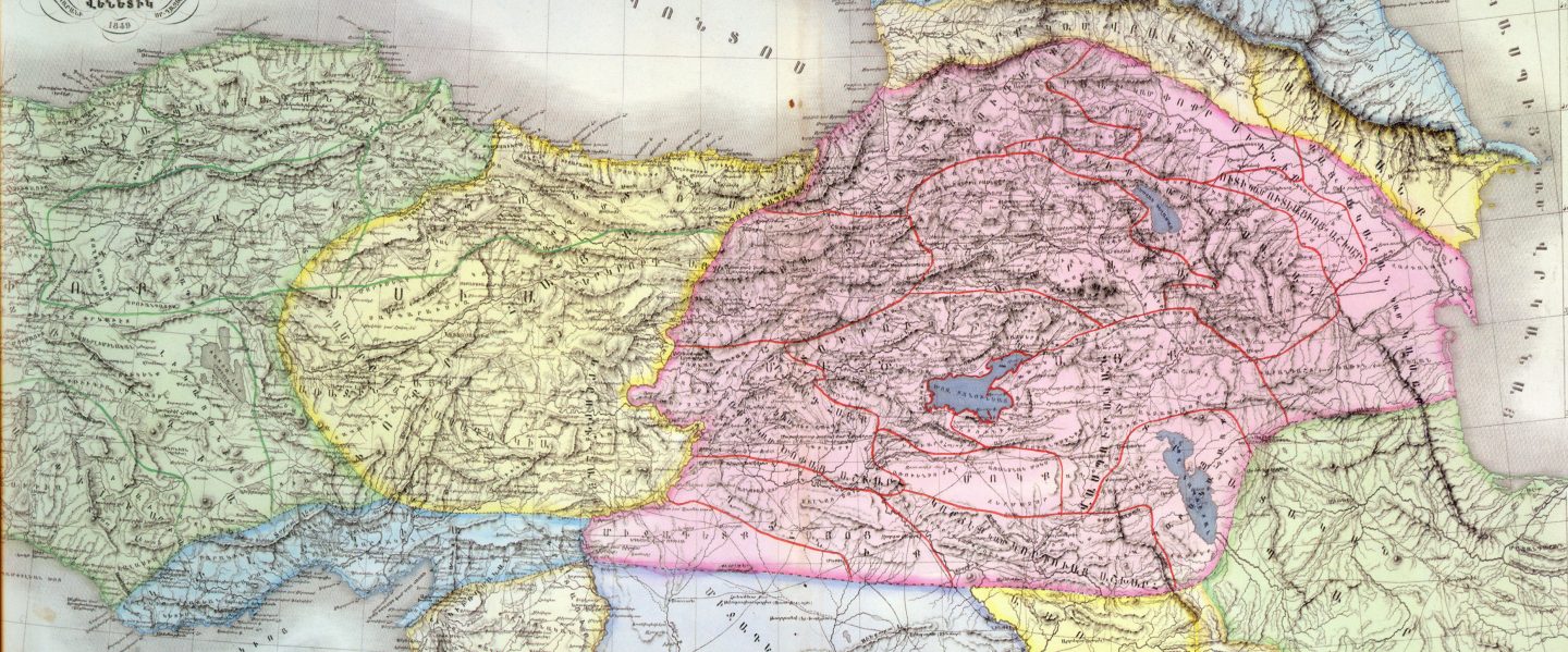


You must be logged in to post a comment.