Հայաստանի վրացատառ քարտեզներ – Карты Армении на Грузинком – Armenia map in Georgian language


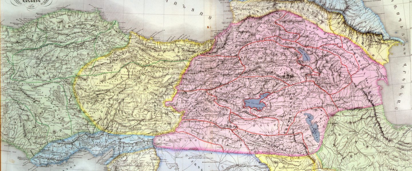

Հայկական Լեռնաշխարհ Армянское Нагорье The Armenian highland
Армянское Нагорье (арм.-Հայկական Լեռնաշխարհ[Haykakan leṙnašxarh] (Айкакакан Лернашхар) или Հայկական Բարձրավանդակ (Айкакан Бардзравандак) или Հայկական Բնաշխարհ (Айкакакан Бнашхар), Միջնաշխարհ Հայոց (Миджнашхар айоц (арм. Средний мир армян)), рус.-Армянское Нагорье , Гор Араратских, Гор Армянских, Армянских Гор, анг.- The Armenian Highland, фр.-Plateau Armenien или Armenian Plateau, нем. Das Armenische Hochland или Das Armenische Bergland).Армянское нагорье-На других языках العربية- المرتفعات الأرمنية— арабский , Беларуская – Армянскае нагор'е, Беларуская (тарашкевіца) – Армянскае нагор’е — беларуская (тарашкевіца),Български – Арменско плато — болгарский, Català – Altiplà d'Armènia, Эрмалойн акъари — чеченский,Čeština-Arménská_vysočina,Armenisches Hochland — немецкий,Αρμενικά υψίπεδα — греческий,English Armenian Highlands — английский, Esperanto -Armena Altebenaĵo, Español – Altiplano Armenio, Eesti-Armeenia mägismaa — эстонский, Euskara-Armeniar goi-ordokia — баскский, فارسی سرزمین کوهستانی ارمنستان — персидский, Français – Haut-plateau arménien — французский,עברית רמת ארמניה — иврит, हिन्दी आर्मीनिया का पठार — хинди, Hrvatski Armenska visoravan — хорватский, Magyar Örmény-felföld — венгерский, Italiano – Altopiano armeno,日本語 -アルメニア高原 — японский, ქართული – სომხეთის მთიანეთი, Қазақша Армения таулы үстірті — казахский, 한국어 아르메니아 고원 — корейский, Lietuvių Armėnijos kalnynas — литовский, Македонски – Ерменска Висорамнина, Nederlands Armeens Hoogland — нидерландский, Norsk nynorsk Det armenske høglandet — нюнорск, Norsk bokmål Det armenske høylandet — норвежский, Polski Wyżyna Armeńska — польский, Português Planalto Armênio — португальский, Srpskohrvatski / српскохрватски Armenska visoravan — сербскохорватский,Simple English Armenian Highland — Simple English, Slovenčina Arménska vysočina — словацкий, Slovenščina Armensko višavje — словенский, Српски / srpski Јерменска висораван — сербский, தமிழ தமிழ ஆர்மேனிய மேட்டுநிலங்கள் — тамильский,Татарча/tatarça Әрмән таулыгы — татарский, Українська Вірменське нагір'я — украинский, Oʻzbekcha/ўзбекча Armaniston togʻligi — узбекский, Tiếng Việt Sơn nguyên Armenia — вьетнамский,中文 亚美尼亚高原 — китайский.
Հայաստանի վրացատառ քարտեզներ – Карты Армении на Грузинком – Armenia map in Georgian language

Armenia
Cilicia
Ancient History
Kizzuwatna
Quwe
Cilician History
Peace Making
Achaemenid Empire
Alexander the Great
Roman Empire
Arabic Conquest
Armenian Cilicia
Queen Isabella
Turkish Migration
Nakhchivan
Early History
Armenian Rule
Arab Rule
Turkish Rule
Russian rule
War and revolution
Soviet Rule
Post Soviet
Cultural Genocide
Artsakh
History of Artsakh
Dizak and Khachen
Armenian Meliks
Karabakh Khanate
Russian Rule
New Caucasian States
Nagorno-Karabakh war 1920
Soviet Rule
The war of Nagorno-Karabakh 1991
Name
The Land of Fire
Western Azerbaijan
Whole Azerbaijan
Language
Ancient History
History
Contemporary history
Independence
Atropatene
Caucasian Albania/Arran
Udis
History
Roman Period
Sassanid Period
Armenian Influences
Christianity
Islamic Era
Azerbaijani historiography
Armenia
Armenia, officially the Republic of Armenia, is a landlocked country in the South Caucasus region of Eurasia. Located in Western Asia, on the Armenian Highlands, it is bordered by Turkey to the west, Georgia to the north, the de facto independent Republic of Artsakh and Azerbaijan to the east, and Iran and Azerbaijan’s exclave of Nakhchivan, or the Nakhchivan Autonomous Republic, to the south.

Cilicia

In antiquity, Cilicia was the south coastal region of Asia Minor, south of the central Anatolian plateau. It existed as a political entity from Hittite times into the Byzantine empire. Cilicia extends inland from the southeastern coast of modern Turkey, due north and northeast of the island of Cyprus.
Cilicia is a geographical region extending inland from the northeastern corner of the Mediterranean Sea; along the Mediterranean coast east from Pamphylia, to the Nur Mountains, which separated it from Syria.
During the High Middle Ages Armenian refugees fleeing the Seljuk invasion of Armenia formed an independent principality named the Armenian Kingdom of Cilicia, also known as the Cilician Armenia, Kingdom of Cilician Armenia or New Armenia.
Located outside of the Armenian Highland and distinct from the Armenian Kingdom of Antiquity, it was centered in the Cilicia region northwest of the Gulf of Alexandretta.
Cilicia was settled from the Neolithic period onwards. It has been a crossroad for cultures, religions and ethnicities throughout its history. Anatolian civilizations, Romans, Greeks, Armenians, Arabs resided and built civilizations at the region.
Historically many people considered it as a part of the Levant. Cilicia is the ancient Roman name for the southeastern region of Asia Minor. It is referenced in the biblical books of Acts and Galatians, was the birthplace of Saint Paul, and the site of his early evangelical missions
North and east of Cilicia lie the rugged Taurus Mountains that separate it from the high central plateau of Anatolia, which are pierced by a narrow gorge, called in antiquity the Cilician Gates, a pass through the Taurus Mountains connecting the low plains of Cilicia to the Anatolian Plateau, by way of the narrow gorge of the Gökoluk River.
Ancient Cilicia was naturally divided into Cilicia Trachaea (“rugged Cilicia”; the Assyrian Hilakku, classical “Cilicia”) and Cilicia Pedias (“flat Cilicia”; Assyrian Kue) by the Limonlu River. Salamis, the city on the east coast of Cyprus, was included in its administrative jurisdiction.
Hilakku was one of the Neo-Hittite states during the Iron Age in southern Anatolia during the 1st millennium BC. Hilakku was north of the Neo-Hittite state of Tabal, west of Que, and north of the Mediterranean sea. It covered the land of Cilicia Tracheia, (Latin Aspera) of the Classical age, otherwise known as ‘Rough Cilicia’. It was also within the south-eastern frontiers of the Hittite appanage domain of Tarhuntassa.
Cilicia Trachea is a rugged mountain district formed by the spurs of Taurus, which often terminate in rocky headlands with small sheltered harbors, a feature which, in classical times, made the coast a string of havens for pirates and, in the Middle Ages, outposts for Genoese and Venetian traders. The district is watered by the Calycadnus and was covered in ancient times by forests that supplied timber to Phoenicia and Egypt.
Cilicia Pedias to the east, included the rugged spurs of Taurus and a large coastal plain, with rich loamy soil for its abundance (euthemia) filled with sesame and millet and olives and pasturage for the horses imported by Solomon. Many of its high places were fortified.
The plain is watered by the three great rivers, the Cydnus (Tarsus Çay), the Sarus (Seyhan) and the Pyramus (Ceyhan River), each of which brings down much silt from the deforested interior and which fed extensive wetlands. The Sarus now enters the sea almost due south of Tarsus, but there are clear indications that at one period it joined the Pyramus, and that the united rivers ran to the sea west of Kara-tash.
Through the rich plain of Issus ran the great highway that linked east and west, on which stood the cities of Tarsus (Tarsa) on the Cydnus, Adana (Adanija) on the Sarus, and Mopsuestia (Missis), an ancient city in Cilicia Campestris on the Pyramus River (now Ceyhan River) located approximately 20 km (12 mi) east of ancient Antiochia in Cilicia (present-day Adana, southern Turkey).
The Greeks invented for Cilicia an eponymous Hellene founder in the purely mythical Cilix, but the historic founder of the dynasty that ruled Cilicia Pedias was Mopsus, identifiable in Phoenician sources as Mpš, the founder of Mopsuestia who gave his name to an oracle nearby. Homer mentions the people of Mopsus, identified as Cilices, as from the Troad in the northernwesternmost part of Anatolia.
Mopsus was the name of one of two famous seers in Greek mythology; his rival being Calchas. A historical or legendary Mopsos or Mukšuš may have been the founder of a house in power at widespread sites in the coastal plains of Pamphylia and Cilicia during the early Iron Age.
Homer mentions the plain as the “Aleian plain” in which Bellerophon wandered, but he transferred the Cilicians far to the west and north and made them allies of Troy. The Cilician cities unknown to Homer already bore their pre-Greek names: Tarzu (Tarsus), Ingira (Anchiale), Danuna-Adana, which retains its ancient name, Pahri (perhaps Mopsuestia), Kundu (Kyinda, then Anazarbus) and Azatiwataya (today’s Karatepe).
The English spelling Cilicia is the same as the Latin, as it was transliterated directly from the Greek form. The palatalization of c occurring in the west in later Vulgar Latin (c. 500–700) accounts for its modern pronunciation in English.
Ancient History
Sometime between 2700-2400 BCE, a people known as the Hatti either migrated into upper Anatolia or were natives of the region who only began making their presence known to the historical record at that time.
The Hatti were an agrarian people who spoke a language called Hattic but wrote using Mesopotamian cuneiform (as did the Hittites). They established their central city, Hattusa, north of Cilicia in c. 2500 BCE and were a powerful force in the region, able to repulse invasion by the formidable Sargon of Akkad (also known as Sargon the Great (r. 2334-2279 BCE) who, failing to take Hattusa, claimed the southern coast line of Cilicia.
Cilicia was held, loosely, by the Akkadian Empire until its collapse c. 2083 BCE at which time the Hatti were able to completely reassert their control (although it is likely they had already done so long before).
The Hatti controlled the ports along Cilicia’s coast until the Hittite king Anitta of the Kingdom of Kussara invaded in 1700 BCE, destroyed Hattusa and established the so-called Old Hittite Kingdom (1700-1500 BCE).
Simultaneously or shortly afterward, a people known as the Luwians, a group of Anatolian peoples who lived in central, western, and southern Asia Minor as well as the northern part of western Levant in the Bronze Age and the Iron Age, enter the record, but little is known of them except for their language.
The Luwians spoke the Luwian language, an Indo-European language of the Anatolian sub-family, which was written in cuneiform imported from Mesopotamia, and a unique native hieroglyphic script, which also was sometimes used by the linguistically related Hittites.
The origin of the Luwians can only be assumed. A wide variety of suggestions exist, even today, which are connected to the debate over the original homeland of the Indo-European speakers. Suggestions for the Indo-European homeland include the Balkans, the Lower Volga and Central Asia.
However, little can be proven about the route that led the ancestors of the Luwians to Anatolia. It is also unclear whether the separation of the Luwians from the Hittites and the Palaic speakers occurred in Anatolia or earlier.
It is possible that the Demircihüyük culture (c.3500–2500 BC), which, like Troy, is located on the northwest Anatolian Mainland but much further inland than Troy itself, is connected with the arrival of Indo-Europeans in Anatolia, since Proto-Anatolian must have split off around 3000 BC at the latest on linguistic grounds.
Certain evidence of the Luwians begins around 2000 BC, with the presence of personal names and loan words in Old Assyrian Empire documents from the Assyrian colony of Kültepe, dating from between 1950 and 1700 BC (Middle Chronology), which shows that Luwian and Hittite were already two distinct languages at this point.
According to most scholars,[who?] the Hittites were then settled in upper Kızılırmak and had their economic and political centre at Neša (Kaneš), from which the Hittite language gained its native name, nešili. The Luwians most likely lived in southern and western Anatolia, perhaps with a political centre at Purushanda.
The Assyrian colonists and traders who were present in Anatolia at this time refer to the local people as nuwaʿum without any differentiation. This term seems to derive from the name of the Luwians, with the change from l/n resulting from the mediation of Hurrian.
The Old Hittite laws from the 17th century BC contain cases relating to the then independent regions of Palā and Luwiya. Traders and displaced people seem to have moved from one country to the other on the basis of agreements between Ḫattusa and Luwiya.
It has been argued that the Luwians never formed a single unified Luwian state, but populated a number of polities where they mixed with other population groups. However, a minority opinion holds that in the end they did form a unified force, and brought about the end of Bronze Age civilization by attacking the Hittites and then other areas as the Sea People.
During the Hittite period, the kingdoms of Šeḫa and Arzawa developed in the west, focused in the Maeander valley. In the south was the state of Kizzuwatna, which was inhabited by a mixture of Hurrians and Luwians. The kingdom of Tarḫuntašša developed during the Hittite New Kingdom, in southern Anatolia. The kingdom of Wilusa was located in northwest Anatolia on the site of Troy. Whether any of these kingdoms represented a Luwian state cannot be clearly determined based on current evidence and is a matter of controversy in contemporary scholarship.
Between 1500-1400 BCE, the Old Kingdom declined but a new Hittite political entity was then established which is now known as the New Kingdom or the Hittite Empire (1400-1200 BCE). Any semblance of an autonomous Cilicia vanished as it became a vassal state of the Hittites. The greatest Hittite king of this period was Suppiluliuma I (r. c. 1344-1322 BCE) who expanded his territory and improved the kingdom’s infrastructure.
The city of Tarsus, a settlement already ancient by this time, was given its name by the Hittites. It was previously known as Tarsisi by the Akkadians, but the Hittites changed it to Tarsa in honor of one of their gods. The neighboring city of Adana (known as Uru Adaniyya) was also improved upon at this time.
In the earlier Hittite era (2nd millennium BC) the area was known as Kizzuwatna. The region was divided into two parts, Uru Adaniya (flat Cilicia), a well-watered plain, and “rough” Cilicia (Tarza), in the mountainous west.
There exists evidence that circa 1650 BC both Hittite kings Hattusili I and Mursili I enjoyed freedom of movement along the Pyramus River (now the Ceyhan River in southern Turkey), proving they exerted strong control over Cilicia in their battles with Syria.
After the death of Murshili around 1595 BC, Hurrians wrested control from the Hitties, and Cilicia was free for two centuries. The first king of free Cilicia, Išputahšu, son of Pariyawatri, was recorded as a “great king” in both cuneiform and Hittite hieroglyphs. Another record of Hittite origins, a treaty between Išputahšu and Telipinu, king of the Hittites, is recorded in both Hittite and Akkadian.
Cilicia was known as Kizzuwatna (also given as Kizzuwadna) under the Hittites. Tarsa was the capital city and Suppiluliuma I, through a series of campaigns and shrewd manipulations, consolidated Hittite control of a vast region stretching across Anatolia, up into Mesopotamia, and down toward Egypt.
Cilicia existed as a political entity from the Hittite era until the Armenian Kingdom of Cilicia, during the late Byzantine Empire. Still, some political autonomy seems to have survived as evidenced by a series of kings, beginning with Isputahsu (c. 15th century BCE), entering into treaties with the Hittites and Mitanni.
In the next century, Cilician king Pilliya finalized treaties with both King Zidanta II of the Hittites and Idrimi of Alalakh, in which Idrimi mentions that he had assaulted several military targets throughout Eastern Cilicia.
Niqmepa, who succeeded Idrimi as king of Alalakh, went so far as to ask for help from a Hurrian rival, Shaushtatar of Mitanni, to try and reduce Cilicia’s power in the region.
It was soon apparent, however, that increased Hittite power would soon prove Niqmepa’s efforts to be futile, as the city of Kizzuwatna soon fell to the Hittites, threatening all of Cilicia. Soon after, King Sunassura II was forced to accept vassalization under the Hittites, becoming the last king of ancient Cilicia.
Suppiluliuma I died of the plague in 1322 BCE and was succeeded by his son Mursilli II (r. 1321-1295 BCE) who continued his father’s policies. His successor, Muwatalli II (r. 1295-1272 BCE), did the same and is best known for his engagement with Ramesses II of Egypt at the Battle of Kadesh in 1274 BCE.
At this time, the Hittite Empire was among the most powerful of the ancient world, but the Assyrians were growing stronger and finally challenged Hittite authority, defeating them at the Battle of Nihriya c. 1245 BCE. After this engagement, Hittite power began to wane, and the empire’s fall was hastened by the arrival of the Sea Peoples who harassed the Mediterranean region c. 1276-1178 BCE.
In the 13th century BC a major population shift occurred as the Sea Peoples overran Cilicia. The Hurrians that resided there deserted the area and moved northeast towards the Taurus Mountains, where they settled in the area of Cappadocia.
After the collapse of the Hittite realm c. 1190 BC, several small principalities developed in northern Syria and southwestern Anatolia. In south-central Anatolia was Tabal which probably consisted of several small city-states, in Cilicia there was Quwê, in northern Syria was Gurgum, on the Euphrates there were Melid, Kummuh, Carchemish and (east of the river) Masuwara, while on the Orontes River there were Unqi-Pattin and Hamath.
The princes and traders of these kingdoms used Hieroglyphic Luwian in inscriptions, the latest of which date to the 8th century BC. The Karatepe Bilingual inscription of prince Azatiwada is particularly important. These states were largely destroyed and incorporated into the Neo-Assyrian Empire (911–605 BC) during the 9th century BC.
Kizzuwatna
Kizzuwatna was the Hittite and Luwian name for ancient Cilicia. It was the name of an ancient Anatolian kingdom in the 2nd millennium BC. It was situated in the highlands of southeastern Anatolia, near the Gulf of İskenderun. It encircled the Taurus Mountains and the Ceyhan river. The center of the kingdom was the city of Kummanni, situated in the highlands. In a later era, the same region was known as Cilicia.
The country possessed valuable resources, such as silver mines in the Taurus Mountains. The slopes of the mountain range are still partly covered by woods. Annual winter rains made agriculture possible in the area at a very early date. The plains at the lower course of the Ceyhan river provided rich cultivated fields.
The area was conquered by the Hittites in the 16th century BC. Around 1500, the area broke off and became the kingdom of Kizzuwatna, whose ruler used the title of “Great King”, like the Hittite ruler. The Hittite king Telipinu had to conclude a treaty with King Išputaḫšu, which was renewed by his successors.
Under King Pilliya, Kizzuwatna became a vassal of the Mitanni. Around 1420, King Šunaššura of Mitanni renounced control of Kizzuwatna and concluded an alliance with the Hittite king Tudḫaliya I. Soon after this, the area seems to have been incorporated into the Hittite empire and remained so until its collapse around 1190 BC at the hands of Assyria and Phrygia.
King Sargon of Akkad claimed to have reached the Taurus Mountains (the silver mountains) in the 23rd century BC. However, archaeology has yet to confirm any Akkadian influence in the area. The trade routes from Assyria to the karum in the Anatolian highlands went through Kizzuwatna by the early 2nd millennium BC.
The kings of Kizzuwatna of the 2nd millennium BC had frequent contact with the Hittites to the north. The earliest Hittite records seem to refer to Kizzuwatna, in Ancient Egyptian Kode or Qode, and Arzawa (Western Anatolia) collectively as Luwia.
Several ethnic groups coexisted in the Kingdom of Kizzuwatna. The Hurrians inhabited this area at least since the beginning of the 2nd millennium BC. The Hittite expansion in the early Old Kingdom period (under Hattusili I and Mursili I) was likely to bring the Hittites and the Luwians to southeastern Anatolia.
The Luwian language was part of the Indo-European language group, with close ties to the Hittite language. Both the local Hittites and the Luwians were likely to contribute to the formation of independent Kizzuwatna after the weakening of the Hittite Old Kingdom.
The toponym Kizzuwatna is possibly a Luwian adaptation of Hittite *kez-udne ‘country on this side (of the mountains)’, while the name Isputahsu is definitely Hittite and not Luwian. Hurrian culture became more prominent in Kizzuwatna once it entered the sphere of influence of the Hurrian kingdom of Mitanni, with whom they shared various degrees of kinship.
Their pantheon was also integrated into the Hittite one, and the goddess Hebat of Kizzuwatna became very important in Hittite religion towards the end of the 13th century BC. A corpus of religious texts called the Kizzuwatna rituals, believed to be at present the earliest Indo-European ritual corpus discovered to date, was discovered at Hattusa.
In the power struggle that arose between the Hittites and the Hurrian kingdom of Mitanni, Kizzuwatna became a strategic partner due to its location. Isputahsu made a treaty with the Hittite king Telepinu. Later, Kizzuwatna shifted its allegiance, perhaps due to a new ruling dynasty.
The city state of Alalakh to the south expanded under its new vigorous leader Idrimi, himself a subject of the Mitannian king Barattarna. King Pilliya of Kizzuwatna had to sign a treaty with Idrimi. Kizzuwatna became an ally of Mitanni from the reign of Shunashura I, until the Hittite king Arnuwanda I overran the country and made it a vassal kingdom.
Due to the exceedingly rough and unfavorable terrain of the Tarsus Mountains, it is likely that in order to remain in a position of prominence among their Hurrian and Luwian speaking neighbors, favorable terms were requested by the Kizzuwanta and subsequently granted.
Kizzuwatna rebelled during the reign of Suppiluliuma I, but remained within the Hittite empire for two hundred years. In the famous Battle of Kadesh (c. 1274 BC), Kizzuwatna supplied troops to the Hittite king. As master equestrians, some of the first in the areas south of the Caucasus region, they provided the horses, later favored by King Solomon, which allowed the more aggressive use of the Hittite chariot in contrast to their Egyptian and Assyrian rivals.
The Kizzuwatna were master craftsman, mining experts and blacksmiths. Being the first to work “black iron” which is understood to have been iron of meteoric origin, into weapons such as maces, swords and warheads for spears. Their location in the mineral rich Tarsus Range gave them ample materials with which to work.
Around 1200 BC an invasion by the Sea Peoples is believed to have temporarily displaced the people of the Cilician plain, though many among the entourage of said peoples were likely to have been composed of Luwian and Hurrians. Possibly to ensure that they had a stake in how the invasions ended for their people, and not be simple victims of them.
After the fall of the Hittite empire, the Neo-Hittite kingdom Quwe (also spelled Que, Kue, Qeve, Coa, Kuê and Keveh) or Hiyawa emerged in the area of former Kizzuwatna. The same state is known as Hume from Babylonian sources. In Luwian the region of Cilicia was known as ‘Hiyawa’.
Arzawa
Arzawa was the name of a region and a political entity (a “kingdom” or a federation of local powers) in Western Anatolia in the second half of the 2nd millennium BC (roughly from the late 15th century BC until the beginning of the 12th century BC). The core of Arzawa is believed to be along the Kaystros River (now known as Küçük Menderes River), with its capital at Apasa, later known as Ephesus.
When the Hittites conquered Arzawa it was divided into three Hittite provinces: a southern province called Mira along the Maeander River, which would later become known as Caria; a northern province called the Seha River Land, along the Gediz River, which would later become known as Lydia; and an eastern province called Hapalla.
Arzawa is already attested in the time of the Hittite Old Kingdom, but lay outside the Hittite realm at that time. The first hostile interaction occurred under King Tudḫaliya I or Tudḫaliya II.
The invasion of the Hittite realm by the Kaskians led to the decline of Hittite power and the expansion of Arzawa, whose king Tarḫuntaradu was asked by Pharaoh Amenhotep III to send one of his daughters to him as a wife. After a long period of warfare, the Arzawan capital of Apaša (Ephesus) was surrendered by King Uḫḫaziti to the Hittites under King Muršili II. Arzawa was split into two vassal states: Mira [de] and Ḫapalla.
Arzawa succeeded the Assuwa league, a confederation (or league) of 22 ancient Anatolian states which also included parts of western Anatolia that formed some time before 1400 BC, when it was defeated by the Hittite Empire, under Tudhaliya I.
Arzawa was the western neighbour and rival of the Middle and New Hittite Kingdoms. On the other hand, it was in close contact with the Ahhiyawa of the Hittite texts, which corresponds to the Achaeans of Mycenaean Greece. Moreover, Achaeans and Arzawa formed a coalition against the Hittites in various periods.
Kummanni
The center of Kizzuwatna was the city of Kummanni (Hittite: Kummiya). Its location is uncertain, but is believed to be near the classical settlement of Comana in Cappadocia. Recent research make a location in Plain Cilicia more likely, presumably at Sirkeli Höyük.
Kummanni was the major cult center of the Hurrian chief deity, Tešup. Its Hurrian name Kummeni simply translates as “The Shrine.”The city persisted into the Early Iron Age, and appears as Kisuatni in Assyrian records.
It was located on the edge of Assyrian influence in the far northeastern corner of Mesopotamia, separating Assyria from Urartu and the highlands of southeastern Anatolia. It was located in the east of Que, the successor of Kizzuwatna. In a later era, the same region was known as Cilicia. The town should not be confused with Kumme, a holy city for Assyrians and Urarteans, located in the highlands between Assyria and Urartu.
The three chief deities in the Urartian pantheon were “the god of Ardini, the god of Kumenu, and the god of Tushpa.” Kumme was still considered a holy city in Assyrian times, both in Assyria and in Urartu]. Adad-nirari II, after re-conquering the city, made sacrifices to “Adad of Kumme.”
Theispas (also known as Teisheba or Teišeba) of Kumenu was the Araratian (Urartian) weather-god, notably the god of storms and thunder. He was also sometimes the god of war. He formed part of a triad along with Khaldi and Shivini. The ancient Araratian cities of Teyseba and Teishebaini were named after Theispas.
He is a counterpart to the Assyrian god Adad, the Vedic God Indra, and the Hurrian god, Teshub. He was often depicted as a man standing on a bull, holding a handful of thunderbolts. His wife was the goddess Huba, who was the counterpart of the Hurrian goddess Hebat.
Lawazantiya was the cultic city of the goddess Šauška and mentioned in Old-Assyrian documents as Luhuzantiya. In Hittite texts the city is known as Lawazantiya, in Ugarit as Lwsnd and in Assyrian Annals as Lusanda.
The earliest mention of the city comes from the Old Assyrian documents as a trading colony in Kaniš, where the place Luḫuzatia is often mentioned. Gojko Barjamovic considers Luḫuzatia and Lawazantiya to be two separate localities, with the former locating in Elbistan. Meanwhile Lawazantiya might be located at Sirkeli Höyük.
Quwe
Quwê was a Syro-Hittite Assyrian vassal state or province at various times from the 9th century BCE to shortly after the death of Ashurbanipal around 627 BCE in the lowlands of eastern Cilicia, and the name of its capital city, tentatively identified with Adana.
The name Que reflects the Assyrian transmission of the indigenous name Hiyawa. The question whether the toponym Hiyawa is related to Ahhiyawa, the Hittite designation of Mycenaean Greeks, is at present hotly debated.
The principal argument in favour of a Greek migration into Cilicia at the end of the Bronze Age is the mention of Muksa/Mopsos as the founder of the local dynasty in indigenous Luwian and Phoenician inscriptions. According to many translations of the Bible, Quwê was the place from which King Solomon obtained horses. (I Kings 10: 28, 29; II Chron. 1:16)
The Çineköy inscription is a Hieroglyphic Luwian-Phoenician bilingual inscription, uncovered in 1997 in Çineköy, Adana Province, Turkey (ancient Cilicia). The village of Çineköy lies 30 km south of Adana. The inscription is dated to the 8th century BC.
Another important inscription of the same type is known as the Karatepe inscription, also known as the Azatiwada inscription, a bilingual inscription on stone slabs consisting of Phoenician and Luwian text each, which enabled the decryption of the Anatolian hieroglyphs.
Both of these inscriptions trace the kings of ancient Adana from the “house of Mopsos” (given in Hieroglyphic Luwian as Muksa and in Phoenician as Mopsos in the form mps). He was a legendary king of antiquity.
The object on which the inscription is found is a monument to the Storm God Tarhunza. In this monumental inscription, Urikki made reference to the relationship between his kingdom and his Assyrian overlords. The inscription was authored by the man known as Urikki in Assyrian texts, which is equivalent to War(a)ika in Luwian.
The question whether it is the same person as Awar(i)ku of the Karatepe inscription or a different one remains debatable. He was the vassal king of Quwê (Assyrian name), the modern Cilicia. In Luwian this region was known as ‘Hiyawa’.
The Çineköy inscription was the subject of a 2006 paper published in the Journal of Near Eastern Studies, in which the author, Robert Rollinger, lends support to the age-old debate of the name “Syria” being derived from “Assyria”. The Luwian inscription reads “Sura/i” whereas the Phoenician translation reads ’ŠR or “Ashur” which, according to Rollinger (2006), “settles the problem once and for all”.
Names similar to Mopsos, whether Greek or Anatolian, are also attested in Near Eastern languages. Since the discovery of a bilingual Hieroglyphic Luwian-Phoenician inscription in Karatepe (in Cilicia) in 1946-7, it has been conjectured that Mopsos was a historical person.
The inscription is dated to c. 700 BC, and the person speaking in it, ’-z-t-w-d (Phoenician) / Azatiwada (Luwian), professes to be king of the d-n-n-y-m / Hiyawa, and describes his dynasty as “the house of M-p-š / Muksa”. Apparently, he is a descendant of Mopsus.
The relationship between the earlier form Muksa, preserved in Luwian treansmission, and the later form M-p-š / Mopsos, preserved in Phoenician transmission, is indicative of the evolution of Greek labiovelars and can hardly be explained otherwise.
The Phoenician name of the people recalls one of the Homeric names of the Greeks, Danaoi with the -m plural, whereas the Luwian name Hiyawa probably goes back to Hittite Ahhiyā(wa), which is, according to most interpretations, the “Achaean”, or Mycenaean Greek, settlement in Asia Minor. Ancient Greek authors ascribe a central role to Mopsus in the colonization of Pamphylia.
A 13th-century date for the historical Mopsus may be confirmed by a Hittite tablet from Boğazkale which mentions a person called Mukšuš in connection with Madduwattaš of Arzawa and Attarsiya of Ahhiyā. This text is dated to the reign of Arnuwandaš III.
Therefore, some scholars associate Mopsus’ activities along the coast of Asia Minor and the Levant with the Sea Peoples’ attacking Egypt in the beginning of the 12th century BC, one of those peoples being the Denyen—comparable to the d-n-n-y-m of the Karatepe inscription. The Sea People identification is, however, questioned by other scholars.
The name of the king erecting the Karatepe inscription, Azatiwada, is probably related to the toponym Aspendos, the name of a city in Pamphylia founded by the Argives according to Strabo. The name of the city is written Estwediius on coins of the 5th century BC. Presumably, it was an earlier Azatiwada, the ancestor of our king, that gave his name to the city.
The name does not appear to be Greek of origin (= Luwian “Lover of the Sun God [Wa(n)da]”?, or “Sun-god (Tiwad) love (him)”, according to a more recent interpretation). The ethnicity of Mopsus himself is not clear: The fragmentary Lydian historiographer Xanthus made him a Lydian campaigning in Phoenicia.
If the transmission of Nicolaus of Damascus, who quotes him, is believable, Xanthus wrote the name with -ks-, like in the Hittite and Luwian texts. Given that Lydian also belongs to the Anatolian language family, it is possible that Xanthus relied on a local non-Greek tradition according to which Mukšuš was a Luwian.
The name Mopsus or Mopsos is also mentioned in the more recently discovered Çineköy inscription. This is also a Hieroglyphic Luwian-Phoenician bilingual inscription, similar to the Karatepe inscription.
Cilician History
The identity of the Sea Peoples is still debated, and even the name they may have called themselves is unknown. “Sea Peoples” is a modern designation coined in c. 1881 CE by the French Egyptologist Gaston Maspero because ancient inscriptions describe them as coming “from the sea”.
Various scholars have suggested they were Etruscans, Trojans, Myceneans, Libyans, or Minoans, or a coalition of some or all, but most scholars either include or define them primarily as Philistines.
The Sea Peoples are best known from the inscriptions of the Egyptian pharaohs Ramesses II (r. 1279-1213 BCE), Merenptah (r. 1213-1203 BCE), and Ramesses III (r. 1186-1155 BCE), and all three describe them as a coalition which came from the sea, struck suddenly, and caused severe damage.
The scholar William H. Stiebing Jr. claims that they may have been Cilicians as one of the ethnicities included in ancient descriptions is the Danuna whom Stiebing claims were most likely from the city of Adana (224).
If so, the Danuna could be considered early Cilician pirates. The Sea Peoples destabilized the region and toppled the already weakened Hittite Empire, eventually allowing the Assyrians to take the region with relative ease.
Under the Assyrians, the eastern fertile plains of Cilicia were called Qu’e, and the western region Hilikku, which provided the basis for the later Greek name Kilikia which was then rendered as Cilicia.
In the ninth century BC it became part of Assyria and remained so until the late seventh century BC. The Cilicians appear as Hilikku in Assyrian inscriptions, and in the early part of the first millennium BC were one of the four chief powers of Western Asia.
The Assyrian king Tiglath Pileser III (r. 745-727 BCE) established the capital at Adana through a governorship but, as with the Akkadian Empire, the Assyrian hold over Cilicia was never firm, and it slipped from their grasp shortly after the death of Sargon II in 705 BCE.
Around this time, the king Muksa (better known as Mopsus, 8th century BCE) ruled from Adana but the region would not remain independent for long as Qu’e was retaken by the Assyrian king Esarhaddon (r. 681-669 BCE) who left Hilikku to anyone who cared to live there. The Assyrians retained control of the region until 612 BCE when their empire collapsed under the invading coalition of Babylonians and Medes.
In the 8th century BC, the region was unified under the rule of the dynasty of Mukšuš, whom the Greeks rendered Mopso and credited as the founder of Mopsuestia, though the capital was Adana. Mopsuestia’s multicultural character is reflected in the bilingual inscriptions of the ninth and eighth centuries, written both in Indo-European hieroglyphic Luwian and West Semitic Phoenician.
Cilicians could manage to protect themselves from Assyrian domination and with the dissolution of the Neo-Assyrian Empire in 612BC, they had established their fully independent kingdom. As being at a geography that is strategically significant, Cilicians could manage to expand their kingdom as north as Halys River in a short period.
Peace Making
With the expansions, Cilician Kingdom became as strong as Babylonia, one of the powerhouses of the time. In 585BC, Herodotus praised Cilician king Syennesis I, the founder of the kingdom, for his efforts in leading negotiations in ending the 5 years’ war between Lydia and Median Kingdom.
War broke out between the two countries and continued for five years, during which both the Lydians and Medes won a number of victories. On one occasion they had an unexpected battle in the dark, an event which occurred after five years of indecisive warfare. The two armies had already engaged and the fight was in progress, when the day was suddenly turned into night. […]
Both Lydians and Medes broke off the engagement when they saw this darkening of the day; they were more anxious than they had been to conclude peace, and a reconciliation was brought about by Syennesis, a Cilician, and Labynetus of Babylon, who were the men responsible both for the pact to keep the peace and for the exchange of marriages between the two kingdoms.
They persuaded Alyattes to give his daughter Aryenis to Astyages, son of Cyaxares – knowing that treaties seldom remain intact without powerful sanctions. Peaceful governance conducted by the Syennesis dynasty, not only kept the kingdom survive, also prevented Achaemenid Empire to attacks Lydians, after Achaemenid invasions of Median lands.
Appuašu, the son of Syennessis, defended the country against the Babylonian king Neriglissar campaign, whose army reached Cilicia and crossed the Taurus mountain range. The Achaemenids, however, could manage to defeat Lydians, thus Appuašu had to recognize the authority of the Persians in 549BBC to keep the local administration with the Cilicians. Cilicia became an autonomous satrapy under the reign of Cyrus II.
Cilicians were independent in their internal affairs and kept this autonomy for almost 150 years. In 401, Syennesis III and his wife Epyaxa supported the revolt of Cyrus the Younger against his brother Artaxerxes II Mnemon.
This was sound policy, because otherwise, Cilicia would have been looted by the rebel army. However, after the defeat of Cyrus at Cunaxa, Syennesis’ position was difficult. Most scholars assume that this behavior marked the end of the independence of Cilicia. After 400, it became a normal satrapy.
Under the Persian empire Cilicia (in Old Persian: Karka) was apparently governed by tributary native kings who bore a Hellenized name or the title of “Syennesis”, but it was officially included in the fourth satrapy by Darius. Xenophon found a queen in power, and no opposition was offered to the march of Cyrus the Younger.
The great highway from the west existed before Cyrus conquered Cilicia. On its long rough descent from the Anatolian plateau to Tarsus, it ran through the narrow pass between walls of rock called the Cilician Gates.
After crossing the low hills east of the Pyramus it passed through a masonry (Cilician) gate, Demir Kapu, and entered the plain of Issus. From that plain one road ran southward through another masonry (Syrian) gate to Alexandretta, and thence crossed Mt. Amanus by the Syrian Gate, Beilan Pass, eventually to Antioch and Syria.
Another road ran northwards through a masonry (Armenian) gate, south of Toprak Kale, and crossed Mt. Amanus by the Armenian Gate, Baghche Pass, to northern Syria and the Euphrates. By the last pass, which was apparently unknown to Alexander, Darius crossed the mountains prior to the battle of Issus. Both passes are short and easy and connect Cilicia Pedias geographically and politically with Syria rather than with Anatolia.
Alexander forded the Halys River in the summer of 333 BC, ending up on the border of southeastern Phrygia and Cilicia. He knew well the writings of Xenophon, and how the Cilician Gates had been “impassable if obstructed by the enemy”.
Alexander reasoned that by force alone he could frighten the defenders and break through, and he gathered his men to do so. In the cover of night they attacked, startling the guards and sending them and their satrap into full flight, setting their crops aflame as they made for Tarsus. This good fortune allowed Alexander and his army to pass unharmed through the Gates and into Cilicia.
After Alexander’s death it was long a battleground of rival Hellenistic monarchs and kingdoms, and for a time fell under Ptolemaic dominion (i.e., Egypt), but finally came to the Seleucids, who, however, never held effectually more than the eastern half. During the Hellenistic era, numerous cities were established in Cilicia, which minted coins showing the badges (gods, animals and objects) associated with each polis.
Roman Empire
Cilicia Trachea became the haunt of pirates, who were subdued by Pompey in 67 BC following a Battle of Korakesion (modern Alanya), and Tarsus was made the capital of the Roman province of Cilicia.
Cilicia Pedias became Roman territory in 103 BC first conquered by Marcus Antonius Orator in his campaign against pirates, with Sulla acting as its first governor, foiling an invasion of Mithridates, and the whole was organized by Pompey, 64 BC, into a province which, for a short time, extended to and included part of Phrygia.
It was reorganized by Julius Caesar, 47 BC, and about 27 BC became part of the province Syria-Cilicia Phoenice. At first the western district was left independent under native kings or priest-dynasts, and a small kingdom, under Tarcondimotus I, was left in the east; but these were finally united to the province by Vespasian, AD 72. Containing 47 known cities, it had been deemed important enough to be governed by a proconsul.
Under Emperor Diocletian’s Tetrarchy (c. 297), Cilicia was governed by a consularis; with Isauria and the Syrian, Mesopotamian, Egyptian and Libyan provinces, formed the Diocesis Orientis. In the late 4th century the African component was split off as Diocese of Egypt. Part of the pretorian prefecture, also called Oriens (‘the East’), included the dioceses of Asiana and Pontica, both in Anatolia, and Thraciae in the Balkans.
Roman Cilicia exported the goats-hair cloth, Cilicium, which was used to make tents. Tarsus was also the birthplace of the early Christian missionary and author St. Paul, writer (or purported writer) of 13 of the 27 books included in the New Testament.
Cilicia had numerous Christian communities and is mentioned six times in the Book of Acts and once in the Epistle to the Galatians (1:21). After Christianity became the official religion of the Roman Empire in the 4th century, Cilicia was included in the territories of the patriarchate of Antioch.
The region was divided into two civil and ecclesiastical provinces: Cilicia Prima, with a metropolitan diocese at Tarsus and suffragan dioceses for Pompeiopolis, Sebaste, Augusta, Corycus, Adana, Mallus and Zephyrium; and Cilicia Secunda, with a metropolitan diocese at Anazarbus and suffragan dioceses for Mopsuestia, Aegae, Epiphania, Irenopolis, Flavias, Castabala, Alexandria, Citidiopolis and Rhosus.
Bishops from the various dioceses of Cilicia were well represented at the First Council of Nicaea in 325 and at the later ecumenical councils. After the division of the Roman Empire, Cilicia became part of the eastern Roman Empire, the Byzantine Empire.
Arabic Conquest
In the 7th century Cilicia was invaded by the Muslim Arabs. The area was for some time an embattled no-man’s land. The Arabs succeeded in conquering the area in the early 8th century. During what is called the Rashidun Caliphate, the first of the four major caliphates established after the death of the Islamic prophet Muhammad, a large part of the area was called “Ath-Thugur As-Shamiyya” meaning the Levantine outskirts.
The Rashidun Caliphate was ruled by the first four successive caliphs (successors) of Muhammad after his death in 632 CE. These caliphs are collectively known in Sunni Islam as the Rashidun, or “Rightly Guided” caliphs. This term is not widely used in Shia Islam as Shia Muslims do not consider the rule of the first three caliphs as legitimate.
Under the Abbasid Caliphate, Cilicia was resettled and transformed into a fortified frontier zone (thughur). Tarsus, re-built in 787/788, quickly became the largest settlement in the region and the Arabs’ most important base in their raids across the Taurus Mountains into Byzantine-held Anatolia.
The Muslims held the country until it was reoccupied by the Emperor Nicephorus II in 965. From this period onward, the area increasingly came to be settled by Armenians, especially as Imperial rule pushed deeper into the Caucasus over the course of the 11th century.
Armenian Kingdom of Cilicia
The Seljuk Turkish invasions of Armenia were followed by an exodus of Armenians migrating westward into the Byzantine Empire, and in 1080 Ruben, a relative of the last king of Ani, founded in the heart of the Cilician Taurus a small principality which gradually expanded into the Armenian Kingdom of Cilicia.
The Armenian Kingdom of Cilicia, also known as Cilician Armenia, Lesser Armenia, or New Armenia, and formerly known as the Armenian Principality of Cilicia, was an Armenian state formed during the High Middle Ages by Armenian refugees fleeing the Seljuk invasion of Armenia.
Located outside the Armenian Highlands and distinct from the Kingdom of Armenia of antiquity, it was centered in the Cilicia region northwest of the Gulf of Alexandretta.
The kingdom had its origins in the principality founded c. 1080 by the Rubenid dynasty, an alleged offshoot of the larger Bagratid family, which at various times had held the throne of Armenia. Their capital was originally at Tarsus, and later became Sis.
During the time of the First Crusade, the area was controlled by the Armenian Kingdom of Cilicia. This Christian state, surrounded by Muslim states hostile to its existence, had a stormy history of about 300 years, giving valuable support to the Crusaders, and trading with the great commercial cities of Italy.
Cilicia was a strong ally of the European Crusaders, and saw itself as a bastion of Christendom in the East. It also served as a focus for Armenian nationalism and culture, since Armenia proper was under foreign occupation at the time.
Cilicia’s significance in Armenian history and statehood is also attested by the transfer of the seat of the Catholicos of the Armenian Apostolic Church, spiritual leader of the Armenian people, to the region. In 1198, with the crowning of Leo the Magnificent of the Rubenid dynasty, Cilician Armenia became a kingdom.
It prospered for three centuries due to the vast network of fortifications which secured all the major roads as well as the three principal harbours at Ayas, Koŕikos, and Mopsuestia.
Through their complex alliances with the Crusader states the Armenian barons and kings often invited the Crusaders to maintain castles in and along the borders of the Kingdom, including Bagras, Trapessac, T‛il Hamtun, Harunia, Selefkia, Amouda, and Sarvandikar.
Gosdantin (r. 1095 – c. 1100) assisted the crusaders on their march to Antioch, and was created knight and marquis. Thoros I (r. c. 1100 – 1129), in alliance with the Christian princes of Syria, waged successful wars against the Byzantines and Seljuk Turks.
Levon II (Leo the Great (r. 1187–1219)), extended the kingdom beyond Mount Taurus and established the capital at Sis. He assisted the crusaders, was crowned King by the Archbishop of Mainz, and married one of the Lusignans of the crusader kingdom Cyprus.
Hetoum I (r. 1226–1270) made an alliance with the Mongols, sending his brother Sempad to the Mongol court in person. The Mongols then assisted with the defense of Cilicia from the Mamluks of Egypt, until the Mongols themselves converted to Islam. When Levon V died (1342), John of Lusignan was crowned king as Gosdantin IV; but he and his successors alienated the native Armenians by attempting to make them conform to the Roman Church, and by giving all posts of honor to Latins, until at last the kingdom, falling prey to internal dissensions, ceded Cilia Pedias to Ramadanid-supported Mamluk Sultanate in 1375. Karamanid Principality one of the Turkmen Anatolian beyliks emerged after the collapse of the Anatolian Seljuks took over the rule of Cilicia Thracea.
In 1226, the crown was passed to rival Hethumids through Leo’s daughter Isabella’s second husband, Hethum I. As the Mongols conquered vast regions of Central Asia and the Middle East, Hethum and succeeding Hethumid rulers sought to create an Armeno-Mongol alliance against common Muslim foes, most notably the Mamluks.
In the thirteenth and fourteenth centuries, the Crusader states and the Mongol Ilkhanate disintegrated, leaving the Armenian Kingdom without any regional allies. After relentless attacks by the Mamluks in Egypt in the fourteenth century, the Cilician Armenia of the Lusignan dynasty, mired in an internal religious conflict, finally fell in 1375.
Commercial and military interactions with Europeans brought new Western influences to the Cilician Armenian society. Many aspects of Western European life were adopted by the nobility including chivalry, fashions in clothing, and the use of French titles, names, and language. Moreover, the organization of the Cilician society shifted from its traditional system to become closer to Western feudalism.
The European Crusaders themselves borrowed know-how, such as elements of Armenian castle-building and church architecture. Cilician Armenia thrived economically, with the port of Ayas serving as a center for East-West trade.
Queen Isabella
The Hethumids, also known as the House of Lampron (after Lampron castle), were the rulers of the Armenian Kingdom of Cilicia from 1226 to 1373. Hethum I, the first of the Hethumids, came to power when he married Queen Isabella of Armenia (Armenian: Զապել, romanized: Zabel), also Isabel (1216/1217-1252), the only child of King Leo I by his second wife, Sybilla of Cyprus.
Isabella was betrothed to Andrew, the third son of King Andrew II of Hungary in 1218, but the betrothal was later broken in favor of a more advantageous Russian marriage for her bridegroom.
King Leo I died on May, 1219. On his death-bed, he named Isabella as his heir; and released the barons from their oath of allegiance to his great-nephew, Raymond-Roupen. But the claim of his five-year-old daughter was contested by Raymond-Roupen and by John of Brienne.
Isabella emerged as the favourite of the ruling Armenian nobles and thus she was proclaimed queen by acclamation and placed under the regency of Adam of Baghras. Adam of Baghras, however, was murdered after a few months; and the regency passed to the only remaining influential Armenian house, that of the Hethumian family, whose head was Constantine of Barbaron.
John of Brienne’s claim was based on his marriage to Leo I’s older daughter Rita (Stephanie). Pope Honorius III recognized John of Brienne’s claim that his wife or her son should succeed.
John of Brienne received the Pope’s permission to leave the Crusade and visit Cilician Armenia in February, 1220. However, as he prepared to sail for Cilicia his Armenian wife died; and when their small son died a few weeks later, he had no further claim on the Armenian throne.
At this juncture, Raymond-Roupen, grandson of Roupen III (the elder brother of Isabella’s father, King Leo I) set up a claim to the throne of Cilicia. He laid claim to the throne by virtue of lineage through his mother Alice, the niece of King Leo I. Moreover, he had long been considered as King Leo I’s heir.
He approached the crusaders at Damietta in 1219 for support in claiming Cilician Armenia, and was able to return in 1221 with some of them and promises from the Papal legate Pelagius.
He found some Armenian support in and around Tarsus, notably Vahram, the castellan of Corycus. Together they conquered from Tarsus to Adana, but then met reverses and were forced to retire to Tarsus where he was captured and ended his days in prison in 1222; his infant daughters retired with their mother to Cyprus.
This event left Isabella the sole and largely incontestable heir to her father’s throne. Cilician Armenia, weakened by wars and in need of strong ally, found a temporary solution in a tie with the Principality of Antioch: the regent suggested that Prince Bohemond IV should send his fourth son, Philip, to marry Isabella, insisting only that the bridegroom should join the separated Armenian Church.
Constantine of Barbaron was soon convinced to seek an alliance with Prince Bohemond IV of Antioch, and he arranged a marriage between the young princess and Philip, a son of Bohemond IV.
Philip, however, offended the Armenians’ sensibilities, and even despoiled the royal palace, sending the royal crown to Antioch; therefore, he was confined in a prison in Sis (now Kozan in Turkey), where he died, presumably poisoned.
Philip agreed to adopt the Armenian faith, communion and customs and to respect the privileges of all nations in Cilician Armenia. Philip married Isabella at Sis in June 1222 and was accepted as king.
The joint rule of Isabella and Philip was brief; Philip’s disdain for the Armenian ritual, which he had promised to respect, and his marked favoritism to the Latin barons angered the Armenian nobility. Philip spent as much time as possible in Antioch.
When it was rumored that Philip wanted to give the crown and throne to Antioch, Constantine of Barbaron led a revolt at the end of 1224. Philip and Isabella were seized at Tall Hamdun (today Toprakkale in Turkey) on their way to Antioch and taken back to Sis, where Philip was imprisoned and probably poisoned at the beginning of 1225.
On the death of her husband, Isabella decided to embrace monastic life and fled to Silifke Castle. She sought refuge with the Hospitallers. The latter were unwilling to give her up to Constantine of Barbaron, but feared the powerful regent; they eased their conscience by selling him the fortress with Isabella in it.
Bohemond IV, in anger, was determined on war, although such a conflict had been expressly forbidden by the pope as harmful for all Christendom. Bohemond IV called in as ally the sultan at Iconium, Kai-Qobad I, and ravaged upper Cilicia in 1225. Constantine of Barbaron arranged for the regent of Aleppo, Toghril, to advance on Antioch. When the latter attacked Baghras, Bohemond IV had to return to his own lands.
Isabella was forced into marriage with Constantine of Barbaron’s son who was subsequently crowned King Hetum I in Tarsus in June 1226. She is said to have refused to consummate the marriage for several years.
The unhappy young Isabella was forced to marry Constantine of Barbaron’s son, Hethum; although for many years she refused to live with him, but in the end she relented. She was queen regnant of Armenian Cilicia from 1219 until her death.
The apparent unification in marriage of the two principal dynastic forces of Cilicia (i.e., the Roupenids and the Hethumids) ended a century of dynastic and territorial rivalry and brought the Hethumids to the forefront of political dominance in Cilician Armenia.
According to Smbat Sparapet: Chronicle: In the year 675 AE /1226/ the Armenian princes, together with the Catholicos, Lord Constantine, assembled and enthroned Hethum, son of Constantine, bailli of the Armenians, and also gave him /as a wife/ Isabel, King Leo’s daughter. Thereafter there was peace in the House of the Armenians, and year by year they strived for the heights.
Constantine of Barbaron now thought it wise to reconcile Armenia with the Papacy: loyal messengers were sent in the name of the young couple to the Pope and to the Emperor Frederick II.
Although Bohemond IV and later his son, Bohemond V attempted to persuade the Pope to arrange a divorce between Isabella and Hethum, but both he and King Henry I of Cyprus were specifically forbidden by Rome to attack the Armenians. The marriage was legalized by Rome in 1237.
There is evidence that Isabella shared a degree of royal power, for we learn from several sources that she co-signed with her husband an official deed transferring to the Knights of the Teutonic Order the strategic castle and town of Haronie.
| 1080 Rupenian Principality established in Cilicia | |
| Roupen I 1080 – 1095 Gostandin I 1095 – 1099 | |
| Cilician Armenians assists First Crusade 1098-1099 | |
| Toros I 1100 – 1129 Prince Levon I 1129 – 1138Byzantine occupation 1138 – 1144Toros II 1145 – 1167 | |
| Second Crusade 1147 – 1149Louis VII of France, Queen Eleanor of Aquitaine, Emperor Conrad III | |
| Roupen II 1167 – 1169 Mleh 1169 – 1174 Roupen II 1174 – 1187 | |
| Roupenian Dynasty | |
| Levon II Prince 1187 – 1198 Levon I King 1199 – 1219 | |
| Third Crusade passes through Cilician Armenia 1189-1192 | |
| Queen Zabel 1219 – 1222 Philip of Antioch 1222 – 1225 | |
| Hetoumian Dynasty | |
| Hetoum I 1226 – 1270 | |
| Hetoum I visits Mangu Khan at Karakorum 1253-1256Mamluk Raid Cilicia 1266-1269 | |
| Levon II 1270 – 1289 | |
| Mamluk Raid of Cilicia 1272 | |
| Hetoum II 1289 – 1293 / 1295 – 1296 / 1299 – 1306 Toros (Prince & Regent) 1293 – 1295 Smpad 1296 – 1298 Gosdantin II 1298 – 1299 Levon III 1301 – 1307 (Co-ruler from 1301-1306) | |
| Mamluk Raid of Cilicia 1301 Hetoum II and Levon III killed by Mongol general Pilarghou 1307 | |
| Oshin 1307 – 1320 | |
| Defeat of the Mamluk at Ayas 1320 | |
| Levon IV 1320 – 1342 | |
| Lusignan Dynasty | |
| Guy Lusignan (Gosdantin II) 1342 – 1344 | |
| Neghirian Dynasty | |
| Gosdantin III 1344 – 1363 | |
| Mamluks capture Adana and Tarsus and devastate Sis 1360 | |
| Levon the Usurper 1363-1365 Gosdantin IV 1365-1373 | |
| Lusignan Dynasty | |
| Levon V Lusignan 1374-1375 | |
| Cilician Armenia conquered by Mamluk 1375 – End of kingdom |
Turkish Migration
Cilicia were part of the Seljuqs for a short time around the turn of the 11th century, thus were not effected from Sunni tariqa expansionism of the 13th century. Yüreğir Turks moved to Cilicia in the late 14th century, and had a distinct culture that influenced from Bektashi traditions which accompanied Shamanic rituals with Islam.
The region was continued to be called Cilicia internationally, during the Ramadanid Emirate, an autonomous administration and a de facto independent beylik that existed from 1352 to 1608 in Cilicia, taking over the rule of the region from the Armenian Kingdom of Cilicia.
The emirate were a protectorate of Mamluk Sultanate up until the end of 14th century, then they were de facto independent for more than a century, and then from 1517, were a protectorate of Ottoman Empire.
After World War I, Cilicia again appeared as a political entity during the three years’ of French rule. The name was unused after the foundation of the Turkish Republic, together with other regional names like Cappadocia and Lycia. It has been getting attention in the last few decades, as Cilicia has now been used in many brand names in the Adana and Mersin provinces.
Nakhchivan
Nakhchivan is a landlocked exclave of the Republic of Azerbaijan. The region are bordering Armenia to the east and north, Iran to the south and west, and Turkey to the northwest. It is an autonomous area of Azerbaijan, governed by its own elected legislature. The region continues to suffer from the effects of the Armenia-Azerbaijan War, and its Karki exclave has been a part of Armenia ever since.
Variations of the name Nakhchivan include Nakhichevan, Naxcivan, Naxçivan, Nachidsheuan, Nakhijevan, Nakhchawan, Nakhitchevan, Nakhjavan, and Nakhdjevan. Nakhchivan is mentioned in Ptolemy’s Geography and by other classical writers as “Naxuana”.
The 19th-century language scholar Johann Heinrich Hübschmann wrote that the name “Nakhichavan” in Armenian literally means “the place of descent”, a Biblical reference to the descent of Noah’s Ark on the adjacent Mount Ararat. Armenian tradition says that Nakhchivan was founded by Noah.
First century Jewish historian Flavius Josephus also wrote about Nakhichevan, saying that its original name “Αποβατηριον, or Place of Descent, is the proper rendering of the Armenian name of this very city”.
Hübschmann noted, however, that it was not known by that name in antiquity, and that the present-day name evolved to “Nakhchivan” from “Naxčawan”. The prefix “Naxč” derives from Naxič or Naxuč (probably a personal name) and “awan” (the modern transcription of Hübschmann’s “avan”) is Armenian for “place, town”.
According to Armenian tradition, Noah’s tomb is located in the town of Nakhchivan. The Tomb of prophet Noah or Noah’s Mausoleum is a mausoleum in the city of Nakhchivan. Architecture of the construction is dated from the 8th century. 19th century Russian and European sources such as the Brockhaus and Efron Encyclopedic Dictionary and John Foster Fraser noted that the local Armenians considered it a holy place.
The current mausoleum was built in 2006. The tomb consists of remains of the lower storey of a former temple. There is a ladder leading to a burial vault. There is a stone column in the middle of the vault. According to legend, relics of Noah are under this column. A portrait describing the mausoleum of Noah 100 years ago painted by Bahruz Kangarli is saved in the National Art Museum of Azerbaijan.
Early History
The oldest material culture artifacts found in the region date back to the Neolithic Age. On the other hand, Azerbaijani archaeologists have found that the history of Nakhchivan dates back to the Stone Age (Paleolithic).
As a result of archaeological diggings, archaeologists discovered a great number of Stone-Age materials in different regions of Nakhchivan. These materials were useful to study the Paleolithic age in Azerbaijan.
Pollen analysis conducted in Gazma Cave (Sharur District) suggests that humans in the Middle Palaeolithic (Mousterian) lived not only in the mountain forests but also in the dry woodlands found in Nakhchivan.
Several archeological sites from the dating from the Neolithic have also been found in Nakhchivan, including the ancient town of Ovchular Tepesi, a settlement from the 5th-3rd millenniums BC, which also includes some of the oldest salt mines in the world.
The very early Kura-Araxes culture flourished in Nakhchivan before spreading to many other areas, as far as Israel. Recent excavations at Ovcular Tepesi allow the dating of the initial stage of formation of Kura-Araxes culture to 4200–3400 BC.
This region reveals the genesis and chronology of this Chalcolithic and Early Bronze Age culture. Kültəpə is an important early Chalcolithic site in Nakhchivan. Another such site is Makhta Kultepe. Soviet scientists decided that Kultepe is the place where the first items made of copper-arsenic alloys, dating back to the 4th millennium BC, were found in the South Caucasus.
Alikemek-Tepesi is an ancient settlement located in Jalilabad District (Azerbaijan), in the Mugan plain along the Aras (river), belonging to the Chalcolithic period, dating to c. 5000 BC. Early levels belonged to the Shulaveri-Shomu culture.
Materials from this site are very close to the materials obtained from monuments of northwestern Iran (Dalma ware). The artifacts of the lower level are similar to those at Kültəpə I in Nakhchivan. In the upper levels, there is also pottery of the northern Ubaid period type.
Some archaeologists speak of the ancient Alikemek-Kul’tepe culture of southeastern Caucasus, that followed the Shulaveri-Shomu culture, and covered the transition from the Neolithic to Chalcolithic periods (c. 4500 BC).
According to A. Courcier: “Situated respectively at the border of the Mugan Steppe and in Nakhichevan (Azerbaijan), the settlements of Alikemek and Kul’tepe I were excavated in the 1950s–1970s and are not dated with certainty.
They probably represent a relatively long period and occupation seems to have started early (probably during the sixth millennium BCE). They covered the Ararat Plain, Nakhichevan, the Mil’skoj and Mugan Steppes and the region around Lake Urmia in north-western Iran. Aratashen (following level II), located on the Ararat plain in the Armavir Province of Armenia, was also part of this culture.
The first occupation phase at Aratashen was preceramic, going back to 6500 BCE. Parallels are found in the southeastern Trans-Caucasia, and in the northeastern Mesopotamia, especially based on the construction techniques and the lithic and bone tools.
Also the pottery, after it appears, is somewhat similar. The best parallels are with Kul Tepe of Nakhichevan to the south, and with the northern Near East, such as the lower levels of Hajji Firuz Tepe, at Dalma Tepe, and at Tilki Tepe.
The Shulaveri-Shomutepe culture, that developed in the neighbouring Kura basin and the Karabakh steppe, does not have close parallels with the early Aratashen artifacts.
First pottery appears at the end of the fifth millennium BC. At this time, the plain of Ararat was in contact with the contemporary populations of northern Mesopotamia, and also with those of the ‘Sioni culture’ of the Kura basin.
The later period pottery of Aratashen is becoming close to that of the Sioni culture, which locally succeeded the Shulaveri-Shomutepe culture. Here we already see the features of the later Kura-Araxes culture pottery.
There’s evidence of very early metallurgy at Aratashen, going back to the first half of the sixth millennium BCE. According to A. Courcier: “In the Neolithic level IId of Aratashen, dated to the beginnings of the sixth millennium BCE, several fragments of copper ores (malachite and azurite) and 57 arsenical copper beads were discovered.
Close to Aratashen, at Khatunark, one fragment of copper ore (malachite) has been discovered in a level dated to the first half of the sixth millennium BCE. This artefact, together with those found at Aratashen, suggest the nascent emergence of metallurgy in the Ararat region already during the Late Neolithic.”
Middle Chalcolithic (5000-3800 BCE.), archeologically better known than Early Chalcolithic, is divided into three spans concerning its ceramic history: Middle Chalcolithic I (5000-4800 BC.), II (4800-4200 BC.), and III (4200-3800 BC.).
The period between the end of the Hajji Firuz and the beginning of the Kura-Araxes phenomena is one of the least known, yet most important eras in the ancient history and chronology of NW Iran. Previous studies demonstrated that the Chalcolithic is still among the least understood periods of prehistoric development in the region.
The emerging picture suggests that the Chaff-faced Ware (CFW) system, whose focus was the highlands, was progressively challenged during the 4th millennium in the north as in the south, by the Kura-Araxes and Uruk expansions, respectively.
After a period of co-existence with both, the CFW culture was superseded in the highlands by the Kura-Araxes phenomenon, whose driving forces probably had some decisive advantage over its regional neighbours: judging by the importance of metallurgy and mining activities in the Kura-Araxes world, this advantage could have been technological.
Dalma Tepe, an archeological site in western Azerbaijan. It is a small mound located about 5 km southwest of Ḥasanlū Tepe just north of the modern village of Dalmā in the Soldūz valley at the southwestern edge of Lake Urmia.
The mound rises about 4 m above the plain level and is approximately 50 m in diameter at the base. It was excavated as part of the Hasanlu Project of The University Museum of Archaeology/Anthropology of the University of Pennsylvania.
The excavations revealed a mass of handmade, chaff-tempered pottery with fine grit inclusions, fired to orange or pink, frequently with a gray core. A few sherds have smoothed, undecorated surfaces and have been labeled “Dalma plain ware.”
A second variety, Dalma impressed ware, was made by impressing the surface of the wet clay with fingertips, textiles, reeds, and other implements. Dalma red-slipped ware was covered with a uniform coat of dark-red paint; it occurred in a variety of shapes, including distinctive “decanting vessels” and horned lugs.
Dalma painted ware consists of deep globular vessels with pinched rims decorated with bold, sweeping patterns of triangles painted in plum, maroon, or brown shades on red. The small objects found at the site are mainly conical clay spindle whorls with concave bases.
Dalma pottery has been found at other sites in the Soldūz valley and along the western side of Lake Urmia. Contemporary and closely similar pottery was excavated at Tepe Seavan (Sīāvān) in the Margavar valley west of Urmia.
Dalma pottery is characteristic of period IX in the main sequence at Ḥasanlū Tepe and can be dated by radiocarbon and comparisons with other sites to around 5000-4500 BC. Imported pottery at Dalmā Tepe links it with level XVI at Tepe Gawra (= Ubaid 3) in northern Iraq.
Pottery similar to Dalma ware has been found at Seh Gābī and Godin Tepe (period X) in the Kangāvar valley to the south. Pottery of Dalma type has also been found in surveys between the Soldūz and Kangāvar valleys.
The Naxçivan Archaeological Project is the first ever joint American-Azerbaijani program of surveys and excavations, that was active since 2006. In 2010–11, they have excavated the large Iron Age fortress of Oğlanqala.
In Nakhchivan, there are also numerous archaeological monuments of the early Iron Age, and they shed a lot of light on the cultural, archaeological and agricultural developments of that era. There are important sites such as Ilikligaya, Irinchoy, and the Sanctuary of Iydali Piri in Kangarli region.
Armenian Rule
The region was part of the state of Urartu and later of Media. It became part of the Satrapy of Armenia under Achaemenid Persia c. 521 BC. After Alexander the Great’s death in 323 BC, various Macedonian generals such as Neoptolemus tried to take control of the region, but ultimately failed and a native Armenian dynasty of Orontids flourished until Armenia was conquered by Antiochus III the Great (ruled 222–187 BC).
In 189 BC, Nakhchivan became part of the new Kingdom of Armenia established by Artaxias I. Within the kingdom, the region of present-day Nakhchivan was part of the Ayrarat, Vaspurakan and Syunik provinces.
According to the early medieval Armenian historian Movses Khorenatsi, from the 3rd to 2nd centuries, the region belonged to the Muratsyan nakharar family but after disputes with central power, King Artavazd I massacred the family and seized the lands and formally attached it to the kingdom.
The area’s status as a major trade center allowed it to prosper; as a result, many foreign powers coveted it. According to the Armenian historian Faustus of Byzantium (5th century), when the Sassanid Persians invaded Armenia, Sassanid King Shapur II (310–380) removed 2,000 Armenian and 16,000 Jewish families in 360–370.
In 428, the Armenian Arshakuni monarchy was abolished and Nakhchivan was annexed by Sassanid Persia. In 623, possession of the region passed to the Byzantine Empire but was soon left to its own rule. Sebeos referred to the area as Tachkastan.
Nakhchivan is said by his pupil, Koriun Vardapet, to be the place where the Armenian scholar and theologian Mesrob Mashtots finished the creation of the Armenian Alphabet and opened the first Armenian schools. It happened in the province of Gokhtan, which corresponds to Nakhchivan’s modern Ordubad district.
Arab Rule
From 640 on, the Arabs invaded Nakhchivan and undertook many campaigns in the area, crushing all resistance and attacking Armenian nobles who remained in contact with the Byzantines or who refused to pay tribute.
In 705, after suppressing an Armenian revolt, Arab viceroy Muhammad ibn Marwan decided to eliminate the Armenian nobility. In Nakhchivan, several hundred Armenian nobles were locked up in churches and burnt, while others were crucified.
The violence caused many Armenian princes to flee to the neighboring Kingdom of Georgia or the Byzantine Empire. Meanwhile, Nakhchivan itself became part of the autonomous Principality of Armenia under Arab control.
In the 8th century, Nakhchivan was one of the scenes of an uprising against the Arabs led by Persian revolutionary Babak Khorramdin of the Iranian Khorram-Dinān (“those of the joyous religion” in Persian).
Nakhchivan was finally released from Arab rule in the 10th century by Bagratuni King Smbat I and handed over to the princes of Syunik. This region also was taken by Sajids in 895 and between 909 and 929, Sallarid between 942 and 971 and Shaddadid between 971 and 1045.
Turkish Rule
About 1055, the Seljuk Turks took over the region. In the 12th century, the city of Nakhchivan became the capital of the state of Atabegs of Azerbaijan, also known as Ildegizid state, which included most of Iranian Azerbaijan and a significant part of the South Caucasus.
The magnificent 12th-century mausoleum of Momine Khatun, the wife of Ildegizid ruler, Great Atabeg Jahan Pehlevan, is the main attraction of modern Nakhchivan. At its heyday, the Ildegizid authority in Nakhchivan and some other areas of South Caucasus was contested by Georgia.
The Armeno-Georgian princely house of Zacharids frequently raided the region when the Atabeg state was in decline in the early years of the 13th century. It was then plundered by invading Mongols in 1220 and Khwarezmians in 1225 and became part of Mongol Empire in 1236 when the Caucasus was invaded by Chormaqan.
In the 13th century during the reign of the Mongol horde ruler Güyük Khan Christians were allowed to build churches in the strongly Muslim town of Nakhchivan, however the conversion to Islam of Gazan khan brought about a reversal of this favor.
The 14th century saw the rise of Armenian Catholicism in Nakhchivan, though by the 15th century the territory became part of the states of Kara Koyunlu and Ak Koyunlu.
The Kara Koyunlu or Qara Qoyunlu, also called the Black Sheep Turkomans, were a Muslim Turkoman monarchy that ruled over the territory comprising present-day Azerbaijan, Georgia, Armenia, northwestern Iran, eastern Turkey, and northeastern Iraq from about 1374 to 1468.
The Aq Qoyunlu or Ak Koyunlu, also called the White Sheep Turkomans, was a Persianate Sunni Turkoman tribal confederation that ruled parts of present-day Eastern Turkey from 1378 to 1501, and in their last decades also ruled Armenia, Azerbaijan, most of Iran, and Iraq.
In the 16th century, control of Nakhchivan passed to the Iranian Safavid dynasty. Until the demise of the Safavids, it remained as an administrative jurisdiction of the Erivan Province (also known as Chokhur-e Sa’d).
Because of its geographic position, it frequently suffered during the wars between the Safavids and the Ottoman Empire, from the 16th to 18th centuries. Turkish historian İbrahim Peçevi described the passing of the Ottoman army from the Ararat plain to Nakhchivan:
“On the twenty-seventh day they reached the plain of Nakhichevan. Out of fear of the victorious army, the people deserted the cities, villages, houses, and places of dwelling, which were so desolate that they were occupied by owls and crows and struck the onlooker with terror. Moreover, they [the Ottomans] ruined and laid waste all of the villages, towns, fields, and buildings along the road over a distance of four or five days’ march so that there was no sign of any buildings or life.”
In 1604, Shah Abbas I of Iran, concerned that the skilled peoples of Nakhichevan, its natural resources, and the surrounding areas could get in danger due to its relatively close proximity to the Ottoman-Persian frontline, decided to institute a scorched earth policy.
He forced the entire hundreds of thousands of local population—Muslims, Jews and Armenians alike—to leave their homes and move to the provinces south of the Aras River. Many of the deportees were settled in the neighborhood of Isfahan that was named New Julfa since most of the residents were from the original Julfa.
The Turkic Kangerli tribe was later permitted to move back under Shah Abbas II (1642–1666) to repopulate the frontier region of his realm. In the 17th century, Nakhchivan was the scene of a peasant movement led by Köroğlu against foreign invaders and “native exploiters”. In 1747, the Nakhchivan Khanate emerged in the region after the death of Nader Shah Afshar.
Russian rule
After the last Russo-Persian War and the Treaty of Turkmenchay, the Nakhchivan Khanate passed into Russian possession in 1828 due to Iran’s forced ceding as a result of the outcome of the war and treaty.
With the onset of Russian rule, the Tsarist authorities encouraged resettlement of Armenians to Nakhchivan and other areas of the Caucasus from the Persian and Ottoman Empires. Special clauses of the Turkmenchay and Adrianople treaties allowed for this.
Alexandr Griboyedov, the Russian envoy to Persia, stated that by the time Nakhchivan came under Russian rule, there had been 290 native Armenians families in the province excluding the city of Nakhchivan, the number of Muslim families was 1,632, and the number of the Armenian immigrant families was 943. The same numbers in the city of Nakhchivan were 114, 392 and 285 respectively.
With such a dramatic influx of Armenian immigrants, Griboyedov noted friction arising between the Armenian and Muslim populations. He requested Russian army commander Count Ivan Paskevich to give orders on resettlement of some of the arriving people further to the region of Daralayaz to quiet the tensions.
The Nakhchivan Khanate was dissolved in 1828 the same year it came into Russian possession, and its territory was merged with the territory of the Erivan khanate and the area became the Nakhchivan uyezd of the new Armenian oblast, which later became the Erivan Governorate in 1849.
According to official statistics of the Russian Empire, by the turn of the 20th century Azerbaijanis made up 57% of the uyezd’s population, while Armenians constituted 42%.
At the same time in the Sharur-Daralagyoz uyezd, the territory of which would form the northern part of modern-day Nakhchivan, Azeris constituted 70.5% of the population, while Armenians made up 27.5%.
During the Russian Revolution of 1905, conflict erupted between the Armenians and the Azeris, culminating in the Armenian-Tatar massacres which saw violence in Nakhchivan in May of that year.
War and revolution
In the final year of World War I, Nakhchivan was the scene of more bloodshed between Armenians and Azerbaijanis, who both laid claim to the area. By 1914, the Armenian population had decreased slightly to 40% while the Azeri population increased to roughly 60%.
After the February Revolution, the region was under the authority of the Special Transcaucasian Committee of the Russian Provisional Government and subsequently of the short-lived Transcaucasian Democratic Federative Republic.
After the 1917 February Revolution, Nakhchivan and its surrounding region were under the authority of the Special Transcaucasian Committee of the Russian Provisional Government and subsequently of the short-lived Transcaucasian Democratic Federative Republic.
When the TDFR was dissolved in May 1918, Nakhchivan, Nagorno-Karabakh, Zangezur (today the Armenian province of Syunik), and Qazakh were heavily contested between the newly formed and short-lived states of the First Republic of Armenia and the Azerbaijan Democratic Republic (ADR).
In June 1918, the region came under Ottoman occupation. Under the terms of the Armistice of Mudros, the Ottomans agreed to pull their troops out of the Transcaucasus to make way for British occupation at the close of the First World War.
In July 1920, the Bolsheviks occupied the region and on July 28, declared the Nakhchivan Autonomous Soviet Socialist Republic with “close ties” to the Azerbaijan SSR, beginning seventy years of Soviet rule.
When the TDFR was dissolved in May 1918, Nakhchivan, Nagorno-Karabakh, Zangezur (today the Armenian province of Syunik), and Qazakh were heavily contested between the newly formed and short-lived states of the Democratic Republic of Armenia (DRA) and the Azerbaijan Democratic Republic (ADR). In June 1918, the region came under Ottoman occupation.
The Ottomans proceeded to massacre 10,000 Armenians and razed 45 of their villages. Under the terms of the Armistice of Mudros, the Ottomans agreed to pull their troops out of the Transcaucasus to make way for the forthcoming British military presence.
Under British occupation, Sir Oliver Wardrop, British Chief Commissioner in the South Caucasus, made a border proposal to solve the conflict. Armenian claims against Azerbaijan should not go beyond the administrative borders of the former Erivan Governorate (which under prior Imperial Russian rule encompassed Nakhchivan), while Azerbaijan was to be limited to the governorates of Baku and Elisabethpol.
This proposal was rejected by both Armenians (who did not wish to give up their claims to Qazakh, Zangezur and Karabakh) and Azeris (who found it unacceptable to give up their claims to Nakhchivan). As disputes between both countries continued, it soon became apparent that the fragile peace under British occupation would not last.
In December 1918, with the support of Azerbaijan’s Musavat Party, Jafargulu Khan Nakhchivanski declared the Republic of Aras in the Nakhchivan uyezd of the former Erivan Governorate assigned to Armenia by Wardrop.
The Armenian government did not recognize the new state and sent its troops into the region to take control of it. The conflict soon erupted into the violent Aras War. British journalist C. E. Bechhofer Roberts described the situation in April 1920:
“You cannot persuade a party of frenzied nationalists that two blacks do not make a white; consequently, no day went by without a catalogue of complaints from both sides, Armenians and Tartars [Azeris], of unprovoked attacks, murders, village burnings and the like. Specifically, the situation was a series of vicious cycles.”
By mid-June 1919, however, Armenia succeeded in establishing control over Nakhchivan and the whole territory of the self-proclaimed republic. The fall of the Aras republic triggered an invasion by the regular Azerbaijani army and by the end of July, Armenian troops were forced to leave Nakhchivan City to the Azeris.
Again, more violence erupted leaving some ten thousand Armenians dead and forty-five Armenian villages destroyed. Meanwhile, feeling the situation to be hopeless and unable to maintain any control over the area, the British decided to withdraw from the region in mid-1919. Still, fighting between Armenians and Azeris continued and after a series of skirmishes that took place throughout the Nakhchivan district, a cease-fire agreement was concluded.
However, the cease-fire lasted only briefly, and by early March 1920, more fighting broke out, primarily in Karabakh between Karabakh Armenians and Azerbaijan’s regular army. This triggered conflicts in other areas with mixed populations, including Nakhchivan.
Soviet Rule
In July 1920, the 11th Soviet Red Army invaded and occupied the region and on July 28, declared the Nakhchivan Autonomous Soviet Socialist Republic with “close ties” to the Azerbaijan SSR.
In November, on the verge of taking over Armenia, the Bolsheviks, to attract public support, promised they would allot Nakhchivan to Armenia, along with Karabakh and Zangezur.
This was fulfilled when Nariman Narimanov, leader of Bolshevik Azerbaijan issued a declaration celebrating the “victory of Soviet power in Armenia”, proclaimed that both Nakhchivan and Zangezur should be awarded to the Armenian people as a sign of the Azerbaijani people’s support for Armenia’s fight against the former DRA government:
“As of today, the old frontiers between Armenia and Azerbaijan are declared to be non-existent. Mountainous Karabagh, Zangezur and Nakhchivan are recognised to be integral parts of the Socialist Republic of Armenia.”
Vladimir Lenin, although welcoming this act of “great Soviet fraternity” where “boundaries had no meaning among the family of Soviet peoples”, did not agree with the motion and instead called for the people of Nakhchivan to be consulted in a referendum. According to the formal figures of this referendum, held at the beginning of 1921, 90% of Nakhchivan’s population wanted to be included in the Azerbaijan SSR “with the rights of an autonomous republic”.
The decision to make Nakhchivan a part of modern-day Azerbaijan was cemented on March 16, 1921 in the Treaty of Moscow between Soviet Russia and the newly founded Republic of Turkey.
The agreement between Soviet Russia and Turkey also called for attachment of the former Sharur-Daralagez uyezd (which had a solid Azeri majority) to Nakhchivan, thus allowing Turkey to share a border with the Azerbaijan SSR. This deal was reaffirmed on October 13, in the Treaty of Kars. Article V of the treaty stated the following:
“The Turkish Government and the Soviet Governments of Armenia and Azerbaijan are agreed that the region of Nakhchivan, within the limits specified by Annex III to the present Treaty, constitutes an autonomous territory under the protection of Azerbaijan.”
So, on February 9, 1924, the Soviet Union officially established the Nakhchivan ASSR. Its constitution was adopted on April 18, 1926. As a constituent part of the Soviet Union, tensions lessened over the ethnic composition of Nakhchivan or any territorial claims regarding it. Instead, it became an important point of industrial production with particular emphasis on the mining of minerals such as salt.
Under Soviet rule, it was once a major junction on the Moscow-Tehran railway line as well as the Baku-Yerevan railway. It also served as an important strategic area during the Cold War, sharing borders with both Turkey (a NATO member state) and Iran (a close ally of the West until the Iranian Revolution of 1979).
Facilities improved during Soviet times. Education and public health especially began to see some major changes. In 1913, Nakhchivan only had two hospitals with a total of 20 beds. The region was plagued by widespread diseases including trachoma and typhus.
Malaria, which mostly came from the adjoining Aras River, brought serious harm to the region. At any one time, between 70% and 85% of Nakhchivan’s population was infected with malaria, and in the region of Norashen (present-day Sharur) almost 100% were struck with the disease. This improved dramatically under Soviet rule. Malaria was sharply reduced and trachoma, typhus, and relapsing fever were completely eliminated.
During the Soviet era, Nakhchivan saw a significant demographic shift. Its Armenian population gradually decreased as many emigrated to the Armenian SSR. In 1926, 15% of region’s population was Armenian, but by 1979, this number had shrunk to 1.4%. The Azeri population, meanwhile, increased substantially with both a higher birth rate and immigration from Armenia (going from 85% in 1926 to 96% by 1979).
Armenians in Nagorno-Karabakh noted similar though slower demographic trends and feared an eventual “de-Armenianization” of the area. When tensions between Armenians and Azeris were reignited in the late-1980s by the Nagorno-Karabakh conflict, Azerbaijan’s Popular Front managed to pressure the Azerbaijan SSR to instigate a partial railway and air blockade against Armenia.
Another reason for disruption of rail service to Armenia were attacks of Armenian forces on the trains entering the Armenian territory from Azerbaijan, which resulted in railroad personnel refusing to enter Armenia.
This effectively crippled Armenia’s economy, as 85% of the cargo and goods arrived through rail traffic. In response, Armenia closed the railway to Nakhchivan, thereby strangling the exclave’s only link to the rest of the Soviet Union.
December 1989 saw unrest in Nakhchivan as its Azeri inhabitants moved to physically dismantle the Soviet border with Iran to flee the area and meet their ethnic Azeri cousins in northern Iran. This action was angrily denounced by the Soviet leadership and the Soviet media accused the Azeris of “embracing Islamic fundamentalism”.
In January 1990, the Supreme Soviet of the Nakhchivan ASSR issued a declaration stating the intention for Nakhchivan to secede from the USSR to protest the Soviet Union’s actions during Black January (January 19–20, 1990).
It was the first part of the Soviet Union to declare independence, preceding Lithuania’s declaration by only a few weeks. Subsequently, Nakhchivan was independent from Moscow and Baku but was then brought under control by the clan of Heydar Aliyev.
Nakhchivan Autonomous Soviet Socialist Republic
Post Soviet
In January 1990 Nakhchivan declared independence from the USSR to protest against the suppression of the national movement in Azerbaijan, and became the Nakhchivan Autonomous Republic within the newly independent Republic of Azerbaijan a year later.
Heydar Aliyev, the future president of Azerbaijan, returned to his birthplace of Nakhchivan in 1990, after being ousted from his position in the Politburo by Mikhail Gorbachev in 1987. Soon after returning to Nakhchivan, Aliyev was elected to the Supreme Soviet by an overwhelming majority.
Aliyev subsequently resigned from the CPSU and after the failed August 1991 coup against Gorbachev, he called for complete independence for Azerbaijan and denounced Ayaz Mütallibov for supporting the coup. In late 1991, Aliyev consolidated his power base as chairman of the Nakhchivan Supreme Soviet and asserted Nakhchivan’s near-total independence from Baku.
Nakhchivan became a scene of conflict during the Nagorno-Karabakh War. On May 4, 1992, Armenian forces shelled the raion of Sadarak.[67][68][69] The Armenians claimed that the attack was in response to cross-border shelling of Armenian villages by Azeri forces from Nakhchivan.
David Zadoyan, a 42-year-old Armenian physicist and mayor of the region, said that the Armenians lost patience after months of firing by the Azeris. “If they were sitting on our hilltops and harassing us with gunfire, what do you think our response should be?” he asked.
The government of Nakhchivan denied these charges and instead asserted that the Armenian assault was unprovoked and specifically targeted the site of a bridge between Turkey and Nakhchivan.
“The Armenians do not react to diplomatic pressure,” Nakhchivan foreign minister Rza Ibadov told the ITAR-Tass news agency, “It’s vital to speak to them in a language they understand.” Speaking to the agency from the Turkish capital Ankara, Ibadov said that Armenia’s aim in the region was to seize control of Nakhchivan. According to Human Rights Watch, hostilities broke out after three people were killed when Armenian forces began shelling the region.
The heaviest fighting took place on 18 May, when the Armenians captured Nakhchivan’s exclave of Karki, a tiny territory through which Armenia’s main north–south highway passes. The exclave presently remains under Armenian control.
After the fall of Shusha, the Mütallibov government of Azerbaijan accused Armenia of moving to take the whole of Nakhchivan (a claim that was denied by Armenian government officials).
However, Heydar Aliyev declared a unilateral ceasefire on 23 May and sought to conclude a separate peace with Armenia. Armenian President Levon Ter-Petrossian expressed his willingness to sign a cooperation treaty with Nakhchivan to end the fighting and subsequently a cease-fire was agreed upon.
The conflict in the area caused a harsh reaction from Turkey. Turkish Prime Minister Tansu Çiller announced that any Armenian advance on the main territory of Nakhchivan would result in a declaration of war against Armenia. Russian military leaders declared that “third party intervention into the dispute could trigger a Third World War”.
Thousands of Turkish troops were sent to the border between Turkey and Armenia in early September. Russian military forces in Armenia countered their movements by increasing troop levels along the Armenian-Turkish frontier and bolstering defenses in a tense period where war between the two seemed inevitable.
The tension reached its peak, when Turkish heavy artillery shelled the Nakhchivan side of the Nakhchivan-Armenian border, from the Turkish border for two hours. Iran also reacted to Armenia’s attacks by conducting military maneuvers along its border with Nakhchivan in a move widely interpreted as a warning to Armenia.
However, Armenia did not launch any further attacks on Nakhchivan and the presence of Russia’s military warded off any possibility that Turkey might play a military role in the conflict. After a period of political instability, the Parliament of Azerbaijan turned to Heydar Aliyev and invited him to return from exile in Nakhchivan to lead the country in 1993.
Today, Nakhchivan retains its autonomy as the Nakhchivan Autonomous Republic and is internationally recognized as a constituent part of Azerbaijan governed by its own elected legislative assembly.
A new constitution for Nakhchivan was approved in a referendum on November 12, 1995. The constitution was adopted by the republic’s assembly on April 28, 1998 and has been in force since January 8, 1999.
However, the republic remains isolated, not only from the rest of Azerbaijan, but practically from the entire South Caucasus region. Vasif Talibov, who is related by marriage to Azerbaijan’s ruling family, the Aliyevs, serves as the current parliamentary chairman of the republic.
He is known for his authoritarian and largely corrupt rule of the region. Most residents prefer to watch Turkish television as opposed to Nakhchivan television, which one Azerbaijani journalist criticised as “a propaganda vehicle for Talibov and the Aliyevs.”
Economic hardships and energy shortages (due to Armenia’s continued blockade of the region in response to the Azeri and Turkish blockade of Armenia) plague the area. There have been many cases of migrant workers seeking jobs in neighboring Turkey. In fact, emigration rates to Turkey are so high that most of the residents of the Besler district in Istanbul are Nakhchivanis.
Cultural Genocide
The number of named Armenian churches known to have existed in the Nakhichevan region is over 280. In as early as 1648 French traveller Alexandre de Rhodes reported seeing more than ten thousand Armenian tombstones made of marble in Julfa.
The number of ecclesiastical monuments still standing in Nakhchivan in the 1980s is estimated to be between 59 and 100. The author and journalist Sylvain Besson believes them to have all been subsequently destroyed as part of a campaign by the Government of Azerbaijan to erase all traces of Armenian culture on its soil.
When the 14th-century church of St. Stephanos at Abrakunis was visited in 2005, it was found to have been recently destroyed, with its site reduced to a few bricks sticking out of loose, bare earth. A similar complete destruction had happened to the 16th century St. Hakop-Hayrapet church in Shurut. The Armenian churches in Norashen, Kırna and Gah that were standing in the 1980s had also vanished.
The most publicised case of mass destruction concerns gravestones at a medieval cemetery in Julfa, with photographic, video and satellite evidence supporting the charges. In April 2006 British
The Times wrote about the destruction of the cemetery in the following way: “A Medieval cemetery regarded as one of the wonders of the Caucasus has been erased from the Earth in an act of cultural vandalism likened to the Taleban blowing up the Bamiyan Buddhas in Afghanistan in 2001.
The Jugha cemetery was a unique collection of several thousand carved stone crosses on Azerbaijan’s southern border with Iran. But after 18 years of conflict between Azerbaijan and its western neighbour, Armenia, it has been confirmed that the cemetery has vanished.”
The Armenians have long been sounding the alarm that the Azerbaijanis intend to eliminate all evidence of Armenian presence in Nakhichevan and to this end have been carrying out massive and irreversible destruction of Armenian cultural traces. “The irony is that this destruction has taken place not during a time of war but at a time of peace,” Armenian Foreign Minister Vartan Oskanian told The Times.
Azerbaijan has consistently denied these accusations. For example, according to the Azerbaijani ambassador to the US, Hafiz Pashayev, the videos and photographs “show some unknown people destroying mid-size stones”, and “it is not clear of what nationality those people are”, and the reports are Armenian propaganda designed to divert attention from what he claimed was a “state policy (by Armenia) to destroy the historical and cultural monuments in the occupied Azeri territories”.
A number of international organizations have confirmed the complete destruction of the cemetery. The Institute for War and Peace Reporting reported on April 19, 2006 that “there is nothing left of the celebrated stone crosses of Jugha.”
According to the International Council on Monuments and Sites (Icomos), the Azerbaijan government removed 800 khachkars in 1998. Though the destruction was halted following protests from UNESCO, it resumed four years later. By January 2003 “the 1,500-year-old cemetery had completely been flattened” according to Icomos.
On December 8, 2010, the American Association for the Advancement of Science released a report entitled “Satellite Images Show Disappearance of Armenian Artifacts in Azerbaijan”. The report contained the analysis of high resolution satellite images of the Julfa cemetery, which verified the destruction of the khatckars.
The European Parliament has formally called on Azerbaijan to stop the demolition as a breach of the UNESCO World Heritage Convention. According to its resolution regarding cultural monuments in the South Caucasus, the European Parliament “condemns strongly the destruction of the Julfa cemetery as well as the destruction of all sites of historical importance that has taken place on Armenian or Azerbaijani territory, and condemns any such action that seeks to destroy cultural heritage.”
In 2006, Azerbaijan barred a Parliamentary Assembly of the Council of Europe (PACE) mission from inspecting and examining the ancient burial site, stating that it would only accept a delegation if it also visited Armenian-controlled territory.
“We think that if a comprehensive approach is taken to the problems that have been raised,” said Azerbaijani foreign ministry spokesman Tahir Tagizade, “it will be possible to study Christian monuments on the territory of Azerbaijan, including in the Nakhchivan Autonomous Republic.”
A renewed attempt was planned by PACE inspectors for August 29 – September 6, 2007, led by British MP Edward O’Hara. As well as Nakhchivan, the delegation would visit Baku, Yerevan, Tbilisi, and Nagorno Karabakh.
The inspectors planned to visit Nagorno Karabakh via Armenia; however, on August 28, the head of the Azerbaijani delegation to PACE released a demand that the inspectors must enter Nagorno Karabakh via Azerbaijan.
On August 29, PACE Secretary General Mateo Sorinas announced that the visit had to be cancelled because of the difficulty in accessing Nagorno Karabakh using the route required by Azerbaijan.
The Ministry of Foreign Affairs in Armenia issued a statement saying that Azerbaijan had stopped the visit “due solely to their intent to veil the demolition of Armenian monuments in Nakhijevan”.
Khachkar destruction in Nakhchivan
Artsakh
Artsakh, officially the Republic of Artsakh or the Nagorno-Karabakh Republic, is a breakaway state in the South Caucasus that is internationally recognized as part of Azerbaijan. Artsakh controls most of the territory of the former Nagorno-Karabakh Autonomous Oblast along with some surrounding territory, giving borders with Armenia to the west and Iran to the south. Its capital is Stepanakert.
The country is very mountainous, averaging 1,100 metres (3,600 ft) above sea level. The population is predominantly ethnic Armenian, and the primary spoken language is the Armenian language. The population is overwhelmingly Christian, most being affiliated with the Armenian Apostolic Church. Several historical monasteries are popular with tourists, mostly from the Armenian diaspora, as most travel can take place only between Armenia and Artsakh.
Artsakh is located in the southern part of the Lesser Caucasus range, at the eastern edge of the Armenian Highlands, encompassing the highland part of the wider geographical region known as Karabakh. Under Russian and Soviet rule, the region came to be known as Nagorno-Karabakh, meaning “Mountainous Karabakh” in Russian.
The name Karabakh itself (derived from Turkic and Persian, and literary meaning “Black Vineyard”) was first employed in Georgian and Persian sources from the 13th and 14th centuries to refer to an Armenian principality known by modern historians as the Kingdom of Artsakh or Khachen.
Currently, most of this area is under the control of the de facto Artsakh Republic, which has economic, political, and military support from Armenia, but the region is de jure recognized as part of Azerbaijan. The final status of the region is still a subject of negotiations between Armenia and Azerbaijan. This article encompasses the history of the region from the ancient to the modern period.
According to Armenian and Western specialists, inscriptions dating to the Urartian period mention the region under a variety of names: “Ardakh”, “Urdekhe”, and “Atakhuni”. In speaking about Armenia in his Geography, the classical historian Strabo refers to an Armenian region which he calls “Orchistene”, which again is believed to be a Greek version of the old name of Artsakh.
According to another hypothesis put forth by David M. Lang, the ancient name of Artsakh possibly derives from the name of King Artaxias I of Armenia (190–159 BC), founder of the Artaxiad Dynasty and the kingdom of Greater Armenia. Folk etymology holds that the name is derived from “Ar” (Aran) and “tsakh” (woods, garden) (i.e., the gardens of Aran Sisakean, the first nakharar of northeastern Armenia).
Nakharar, from Parthian naxvadār (“holder of the primacy”) was a hereditary title of the highest order given to houses of the ancient and medieval Armenian nobility. The origin of the nakharars seems to stretch back to pagan Armenia, which coexisted with the Roman and Parthian Empires, and they are mentioned to have pillaged many pagan temples when Armenia’s conversion to Christianity began under Tiridates III.
Medieval Armenia was divided into large estates, which were the property of an enlarged noble family and were ruled by a member of it, to whom the title of nahapet “chief of the family” or tanuter “master of the house” was given. Other members of a nakharar family in their turn ruled over smaller portions of the family estate. Nakharars with greater authority were recognized as ishkhans (princes).
In western Armenia under Byzantine rule, Justinian’s reforms removed the martial role of the nakharars, as well as attempting to annex estates from Armenian nobles. Justinian I (482 – 565), traditionally known as Justinian the Great and also Saint Justinian the Great in the Eastern Orthodox Church, was the Eastern Roman emperor from 527 to 565.
The nakharars, angered at their restriction in power, began a full-scale insurrection that had to be quelled through swift military intervention, eventually sparking war with the Sassanids. The Sasanian Empire, officially known as the Empire of Iranians (Ērānshahr), also called the Neo-Persian Empire by historians, was the last kingdom of the Persian Empire before the spread of Islam.
Though weakened by numerous invasions and the legal reforms of kings, the nakharar structure remained virtually unchanged for many centuries and was finally eliminated during the Mongol invasions in the thirteenth century. Certain aspects of the nakharar system remained intact in Armenia until the early 20th century, when the noble class was altogether abolished by the Bolsheviks.
The predominantly Armenian-populated region of Nagorno-Karabakh was claimed by both the Azerbaijan Democratic Republic and the First Republic of Armenia when both countries became independent in 1918 after the fall of the Russian Empire, and a brief war over the region broke out in 1920. The dispute was largely shelved after the Soviet Union established control over the area, and created the Nagorno-Karabakh Autonomous Oblast (NKAO) within the Azerbaijan SSR in 1923.
During the fall of the Soviet Union, the region re-emerged as a source of dispute between Armenia and Azerbaijan. In 1991, a referendum held in the NKAO and the neighbouring Shahumian region resulted in a declaration of independence. Ethnic conflict led to the 1991–1994 Nagorno-Karabakh War, which ended with a ceasefire along roughly the current borders.
Nagorno-Karabakh Autonomous Oblast
History of Artsakh
The region of Nagorno-Karabakh was occupied by the people known to modern archaeologists as the Kura-Araxes, and is located between the two rivers bearing those names. Little is known about the ancient history of the region, primarily because of the scarcity of historical sources.
Artsakh was the tenth province (nahang) of the Kingdom of Armenia from 189 BC until 387 AD and afterwards a region of the Caucasian Albanian satrapy of Sasanid Persia from 387 to the 7th century. From the 7th to 9th centuries, it fell under Arab control.
In 821, it formed the Armenian principality of Khachen and around the year 1000 was proclaimed the Kingdom of Artsakh, one of the last medieval eastern Armenian kingdoms and principalities to maintain its autonomy following the Turkic invasions of the 11th to 14th centuries.
According to the local traditions held by many people in the area, the two river valleys in Nagorno-Karabakh were among the first to be settled by Noah’s descendants. According to a 5th-century CE Armenian tradition, a local chieftain named Aran was appointed by the Parthian King Vologases I (Vagharsh I) to be the first governor of this province.
Ancient Armenian authors, Movses Khorenatsi and Movses Kaghankatvatsi, name of it Aran the ancestor inhabitants of Artsakh and next province Utik, the descendant of Sisak (the ancestor and eponym next province Sisakan, differently Siunik), and through it—the descendant of Haik, the ancestor and eponym of all Armenians.
The earliest record of the region covered by modern-day Artsakh is in inscriptions of Sardur II, King of Urartu (763–734 BC), found in village Tsovk in Armenia, as the region Urtekhini. Then—in our data—a breakdown to the Roman epoch.
Urartian inscriptions referring to the region as Urtekhini. It is unclear if the region was ever ruled by Urartu, but it was in close proximity to other Urartian domains. It may have been inhabited by Caspian tribes and/or by Scythians.
After decades of raids by the Cimmerians, Scythians, and the Medes, Urartu finally collapsed with the rise of the Median Empire, and shortly after, the geopolitical region previously ruled as Urartu re-emerged as Armenia.
By the 5th century BC, Artsakh was part of Armenia under the Orontid Dynasty. It would continue to be part of the Kingdom of Armenia under the Artaxiad Dynasty, under which Armenia became one of the largest realms in Western Asia.
At its greatest extent, the Great King of Armenia, Tigranes II, built several cities named after himself in regions he considered particularly important, one of which was the city he built in Artsakh.
A following mention—already at Strabo which characterizes “Orkhistena” (Artsakh) as “the area of Armenia exposing the greatest number of horsemen”. It is unclear when Orkhistena became part of Armenia. Strabo, carefully listing all gains of Armenian Kings since 189 BC., does not mention Orkhistena, which indirectly shows that it probably has been an accessory of the Armenian empire to which it could get in the inheritance from Persian satrapy “East Armenia”.
Ruins of the city Tigranakert are near the modern city of Agdam. It is one of four cities with such a name that were built in the beginning of 1 BC by king of Armenia Tigranes the Great. Recently Armenian archaeologists have led excavation of this city.
Fragments of a fortress, and also hundreds the ancient subjects similar to subjects, found in Armenia. Fencing of a citadel and basilica of 5th–6th centuries AD have been revealed. Excavation have shown, that the city existed since the 1st century BC until the 13th or 14th century AD.
Following wars with the Romans and Persians, Armenia was partitioned between the two empires. Artsakh was removed from Persian Armenia and included into the neighbouring satrapy of Arran. Artsakh would remain part of Arran throughout Persian rule, during the fall of Iran to the Muslims, and following the Muslim conquest of Armenia.
Ancient inhabitants of Artsakh spoke a special dialect of the Armenian language, which was described around this time in the 7th century AD by a contemporary author of the Armenian grammar named Stepanos Siunetsi who lived in around 700 AD. It is among the earliest ever recorded dialects of Armenian.
Strabo and authors of the 1st and 2nd centuries—Claudius Ptolemaeus and Pliny the Elder—unanimously approve, that border between Greater Armenia and Caucasian Albania is river Cyrus (Kura).
Authoritative encyclopedias on antiquity also name Kura southern border of Albania. Artsakh is much to the south of this river. Certificates which would approve its accessory Caucasus Albania or to other state up to the end of the 4th century, does not exist.
Armenian historian Faustus of Byzantium wrote that during an epoch of the disorders which followed intrusion of Persians into Armenia (about 370), Artsakh appeared among the risen provinces, whereas Utik has been grasped by Caucasus Albanians.
Armenian military commander Mushegh Mamikonian defeated the country of Artsakh in a big battle, made many inhabitants of the region prisoners, took hostages from the rest, and imposed a tribute on them. In 372 Mushegh defeated the Caucasus Albanians, took from them Utik, and restored the border on Kura, “as was earlier”.
According to “Geography” (Ashkharatsuyts) by 7th-century Armenian geographer Anania Shirakatsi, Artsakh was the 10th among the 15 provinces (nahangs) of Armenia, and consisted of 12 districts (gavars).
However Anania writes, that during its time Atrsakh together with the next districts “will tear away from Armenia”. And it is valid, in 387 Armenia has been divided between Roman Empire and Persia; thus Artsakh together with Armenian provinces Utik and Paytakaran was attached to Caucasian Albania
At this time, the population of Artsakh consisted of Armenians and Armenicized aborigines, though many of the latter were still cited as distinct ethnic entities. Under the Arabs, most of the South Caucasus and the Armenian Highlands, including Iberia and Arran, would be unified into an emirate called Arminiya, under which Artsakh would continue to remain as part of Arran.
In 469 the kingdom of Albania was reformed into a Sassanid Persian marzpanate (frontier province). In the early 4th century Christianity spread in Artsakh. At the beginning of the 5th century, thanks to the creation of the Armenian alphabet by Mesrop Mashtots, an unprecedented rise of culture began in whole Armenia, in particular also in Artsakh, Mesrop Mashtots having founded one of the first Armenian schools at the Artsakh Amaras Monastery
In the 5th century the eastern part of Armenia, including Artsakh, remained under Persian rule. In 451 the Armenians in response to the policy of compulsion of their Zoroastrian Persian overlords organized a powerful revolt known as the Vardan war.
Artsakh took part in that war, its cavalry having particularly distinguished itself. After the suppression of the revolt by Persia the considerable part of the Armenian forces took shelter in the impregnable fortresses and thick woods of Artsakh to continue further struggle against the foreign yoke.
At the end of the same century Artsakh and neighboring Utik united under the rule of the Aranshakhiks with Vachagan the Devout at the head (487–510’s). Under the latter a considerable rise in culture and science is observed in Artsakh. According to the evidence of a contemporary, in those years in the land there were built as many churches and monasteries as there are days in a year.
At the turn of the 7th century the Albanian marzpanate broke up into several small principalities. In the south Artsakh and Utik created a separate Armenian principality, that of the Aranshakhiks. In the 7th century the Armenian Aranshakhiks were replaced by the Migranians or Mihranids, a dynasty of Persian origin which, becoming related with the Aranshakhiks, turned to Christianity and became rapidly Armenicized.
In the second half of the 7th century in the initial period of the Arab dominion, political and cultural life in Artsakh did not cease. In the 7th and 8th centuries a distinctive Christian culture was shaped. The monasteries Amaras, Orek, Katarovank, Djrvshtik and others acquired a significance that transcended the local area and spread across the Armenian lands
Despite being under Persian and Arab rule, many of the Armenian territories, including Artsakh, were governed by Armenian nobility. Arran would gradually disappear as a geopolitical entity, and its population would be assimilated by neighbouring ethnic groups with whom they shared a common culture and religion. Many Christians from Arran would form part of the ethnic composition of the Armenians living in modern-day Artsakh.
Fragmentation of Arab authority provided the opportunity for the resurgence of an Armenian state in the Armenian Highlands. One particular noble dynasty, the Bagratids, began annexing territories from other Armenian nobles, which, in the later half of the 9th century gave rise to a new Armenian kingdom which included Artsakh.
The new Kingdom wouldn’t stay united for long, however, due to internal conflicts, civil wars, and external pressures, Armenia would often find itself fragmented between other noble Armenian houses, most notably the Mamikonian and Siunia families, the latter of which would produce a cadet branch known as the House of Khachen, named after their stronghold in Artsakh.
Dizak and Khachen
From the beginning of the 9th century, princely houses of Khachen and Dizak were storing up strength. The prince of Khachen, Sahl Smbatean century became one of the most favorable periods for the land’s flourishing.
During this time, valuable architecture was constructed, such as Hovanes Mkrtich (John the Baptist) church and the vestibule of Gandzasar monastery (1216–1260; ancient residence of the Armenian Catholicos of Albania), the Dadi Monastery Cathedral Church (1214), and Gtchavank Cathedral Church (1241–1248). These churches are considered to be the masterpieces of the Armenian architecture.
In 30–40 years of the 13th century the Tatar and Mongols conquered Transcaucasia. The efforts of the Artsakh-Khachen king Hasan-Jalal succeeded in partially saving the land from being destroyed. However, after his death in 1261, Khachen became another victim of the Tatars and Mongols.
The situation became still more aggravating in the 14th century in the years of the subsequent Turkic federations the Qara Koyunlu and Aq Qoyunlu, having replaced the Tatars and Mongols. During this period the area received its Turkic name Karabakh (Combination of “black” (Kara) in Turkic and “garden” (bakh) in Persian) for the first time.
However, it is necessary to mention that as the name Karabakh referred to not only present Nagorno-Karabah (Mountain Karabah), and also (and mainly) Flat Karabakh, that is the plain before merge of rivers Arax and Kura where Turkic nomads began to prevail.
The centuries-long subjection of the local Armenians to Muslim leaders, their relation with Turkic tribal elders and frequent cases of Turkic-Armenian-Iranian intermarriage resulted in Armenians adopting elements of Perso-Turkic Muslim culture, such as language, personal names, music, an increasingly humble position of women and, in some cases, even polygamy.
The House of Khachen ruled the Kingdom of Artsakh in the 11th century as an independent kingdom under the protectorate of the Bagratid Kingdom of Armenia. Under the House of Khachen, the region historically called Artsakh would become synonymous with the name “Khachen”.
Following wars with the Byzantine Empire, and with the arrival of Seljuk Turks in the later half of the 11th century, the Kingdom of Armenia collapsed, and Artsakh became the autonomous Principality of Khachen, ruled by the House of Hasan-Jalalyan, within the Kingdom of Georgia for a short time until the Mongols would acquire the region.
Although the Armenians of Artsakh would not rule the lands as fully sovereign entities, the mountainous geography of the location would allow them to maintain a semi-independent or autonomous status within other realms, such as the Timurid, Kara Koyunlu, and Ak Koyunlu realms.
During this time, the lands to the west of the Kura river up to the eastern slopes of the Zangezur mountain range would become known as Karabakh, with the lands of the Principality of Khachen corresponding to the highlands. During the period of Mongol domination, a great number of Armenians left the lowlands of Karabakh and sought refuge in the mountainous heights of the region.
Armenian Meliks
The Principality of Khachen existed until 16th–17th century, but was eventually divided amongst five Armenian princes, known as meliks, who collectively became known as the Five Melikdoms of Karabakh (literally “five principalities of Karabakh”), also referred to as Khamsa, meaning “five” in Arabic):
Giulistan or Talish Melikdom included the territory from Ganja to the bed of the River Tartar. Dzraberd or Charaberd Melikdom was situated in the territory stretching from the River Tartar to the River Khachenaget. Khachen Melikdom existed in the territory from the River Khachenaget to the River Karkar. Varanda Melikdom included the territory from Karkar to the southern side of Big Kirs mountain. Dizak Melikdom stretched from the southern slope of Big Kirs mountain to the River Arax.
In the 16th century, Karabakh came under Iranian rule for the first time in almost a millennium with the rise of the Safavid Empire, within which the territory of modern-day Artsakh became part of the Province of Karabakh. The Armenian princes continued to rule autonomously over the highlands of Karabakh during this time.
While initially subordinate to Persia’s Ganja khanate (ruled by Ziyad-oglu Qajars), which itself was appointed and fully subjective by and to the Safavid Persians, the Armenian meliks were granted a wide degree of autonomy by Safavid Persia over Upper Karabakh, maintaining semi-quasi autonomous control over the region for four centuries, while being under Persian domination.
In the early 18th century, Persia’s military genius and new ruler, Nadir shah took Karabakh out of control of Ganja khans in punishment for their support of the Safavids, and placed the region directly under his own control.
At the same time, the Armenian meliks were granted supreme command over neighboring Armenian principalities and Muslim khans in Caucasus, in return for the meliks’ victories over the invading Ottoman Turks in the 1720s.
According to some historiographers of the 18th century, of those five meliks, only Melik-Hasan-Jalalyans – the rulers of Khachen – were local residents of Karabakh, while the other four had settled from neighboring provinces.
Thus, Melik-Beglaryans of Gulistan were native Utis from the village of Nij in Shirvan; Melik-Israelyans of Jraberd were descendants of the melik of Siunik to south-east and hailed from the village of Magavuz in Zangezur; Melik Shahnazars of Varanda hailed from the region of Armenian Gegharkunik to the east and received the title of meliks from shah Abbas I in reward for their services; Melik-Avanyans of Dizak – were descendants of meliks of Lori, an Armenian princedom to north-west.
These allegation is however discounted by modern scholarship. Modern western scholars Robert Hewsen and Cyril Toumanoff have demonstrated that all of these meliks were the descendants of the House of Khachen.
Thanks to the meliks from the end of the 17th century in Artsakh there arouse and spread the idea of Armenian independence from Persia. Parallel with the armed struggle, Armenians in that period made diplomatic efforts, at first turning to Europe, then – to Russia. Such political and war leaders as Israel Ori, archimandrite Minas, the Catholicos of Gandsasar Yesai Jalalian, iuzbashis (the commanders of hundred; the capitans) Avan and Tarkhan become people leaders.
The absence of power and political instability in the 18th century in Persia created the threat to its integrity. Both Turkey and Russia expected to get its share from the possible breaking up of Persia, Turkey with this purpose striving for enlisting the support of the Dagestan mountaineers, Russia seeking its supporters among Armenians and Georgians.
In 1722, Peter the Great’s Russo-Persian War (1722–23) began. At the very beginning the Russian forces succeeded in occupying Derbent and Baku. Armenians encouraged by the Russians, concluded the union with Georgians and collected an army in the Karabakh.
However their hopes were deceived. Instead of the promised help, Peter the Great advised the Armenians of Artsakh to leave their native places of residence and move to Derbent, Baku, Gilan, Mazandaran where the Russian power had recently been established in the war intending to consolidate its hold on the occupied.
Khanates, attached to Caspia, Russia signed the treaty with Turkey, on July 12, 1724, giving the latter a free hand in the whole Transcaucasus (as far as Shamakha).
In the same year Ottoman troops invaded the land. Their main victim became the Artsakh Armenian population, who, headed by meliks, rose to struggle for its independence, never having received the promised support on Russian side. Yet, Peter the Great’s march gave a new impulse to the struggle of the Armenians.
In the 1720s the in Karabakh formed host concentrated in three military camps or Skhnakhs (fortified place). The first of them, called the Great Skhnakh, was situated in the Mrav Mountains near the Tartar River.
The second Pokr (Minor) Skhnakh was on the slope of the Kirs Mountain in the province of Varanda, and the third in the province of Kapan. Shkhnakhs, i.e. the Armenian host, possessed absolute power. That was a people army with the Council of military leaders, the Catholicos of Gandsasar also entering it and having a great influence.
Proceed from the demands of wartime, meliks shared their power with iuzbashis, all of them having equal rights and obligations at the military councils. The Armenian host at the head of its leaders, Catholicos Yesai, iuzbashis Avan and Tarkhan resisted the Ottoman regular army for a considerably long time.
In 1733, the Armenians, now encouraged by another military genius, who happened to be Nadir Shah Of Persia, in one special appointed day massacred all Ottoman army that stood on the winter quartiers in Khamsa. After that former position of area has been restored.
In gratitude for services rendered to it, Nadir Shah released the meliks of Khamsa from submission to khans of Ganja and appointed the governor above them Avan, melik of Dizak (the main organizer of plot 1733), having given it a title of khan. However, Avan-khan soon died.
Karabakh Khanate
In the mid-18th century, the whole of Karabakh became a semi-independent khanate called the Karabakh Khanate which lasted for about 75 years. In 1747, Turkic ruler Panah Ali Khan Javanshir, by then already a successful naib and royal gérant de maison, found himself displeased with Nader Shah’s attitude towards him during the latters later years of rule, and having gathered many of those deported from Karabakh in 1736, he returned to his homeland.
Due to his reputation as a skillful warrior and his wealthy ancestor’s legacy in Karabakh, Panah Ali proclaimed himself and was soon recognized throughout most of the region as a ruler (khan). The Shah sent troops to bring back the runaway however the order was never fulfilled: Nader Shah himself was killed in Khorasan in June of the same year. The new ruler of Persia, Adil Shah issued a firman (decree) recognizing Panah Ali as the Khan of Karabakh.
Melik of Varanda Shahnazar II, who was at odds with other meliks, was the first to accept suzerainty of Panakh khan. Panakh khan founded the fortress of Shusha at a location, recommended by melik Shahnazar, and made it the capital of Karabakh khanate. By this same time, the region and the whole wider Caucasus region was reasserted under firm Iranian suzerainty by Agha Mohammad Khan of the Qajar dynasty. However, he was assassinated some years afterwards, ever increasing the political unrest in the region.
The Meliks did not wish to reconcile to the new position. They desperately hoped for the aid of the Russians and had entered into a correspondence to Catherine II of Russia and its favorite Grigori Potyomkin. Potyomkin already gave orders, that “at an opportunity its (Ibrahim-khans of Shusha) area which is made of people Armenian to give in board national and thus to renew in Asia the Christian state”.
But khan Ibrahim-Khalil (the son of Panakh-khan) learned about it. In 1785 he arrested the Dzraberd, Gulistan and Dizak meliks, and plundered Gandzasar monastery, and the Catholicos was planted in prison and poisoned. As a result of this the Khamsa melikdoms finally broke down. Ibrahim-khan made the Karabakh khanate a semi-independent princedom, which only nominally recognized Persian rule.
In 1797, Karabakh suffered the invasion of armies of Persian shah Agha Mohammad Khan Qajar, who had just recently dealt with his Georgian subjects in the Tiflis. Shusha was besieged, but Agha Mohammad Khan Qajar was killed in the tent by own servants.
In 1805 Ibrahim-khan signed the Kurekchay Treaty with Imperial Russia, represented by the Russian commander-in-chief in the war against Pavel Tsitsianov, according to which Karabakh khanate became the protectorate of Russia and the latter undertook to maintain Ibrahim-Khalil khan and his descendants as the ruling dynasty of Karabakh.
However the following year Ibrahim-Khalil was killed by the Russian commandant of Shusha, who suspected that khan was trying to flee to Persia. Russia appointed Ibrahim-Khalil’s son Mekhti-Gulu his successor.
The Karabakh khanate, Georgia, and Dagestan passed to Imperial Russia by the Treaty of Gulistan/Northern Karabakh in 1813, before the rest of Transcaucasia was incorporated into the Empire in 1828 by the Treaty of Turkmenchay, following the two subsequent Russo-Persian Wars of the 19th century. In 1822, Mekhti-khan escaped to Persia.
The Armenian princes lost their status as princes (meliks) in 1822. In 1826, in Karabakh the Persian armies with which was and Mekhti-khan have intruded; but they could not grasp Shusha which was protected desperately with Russian and Armenians, and have been expelled by Russian general Madatoff (the Armenian from Karabakh by origin). The Karabakh khanate was dissolved, and the area became part of the Caspian oblast, and then Elizavetpol governorate within the Russian Empire (1823).
Russian Rule
The Russian Empire consolidated its power over the Karabakh Khanate following the Treaty of Gulistan in 1813 and Treaty of Turkmenchay of 1828, when following two Russo-Persian wars, Persia recognized Karabakh Khanate, along with many other khanates, as part of Russia.
The Karabakh khanate was eliminated in 1822. A survey prepared by the Russian imperial authorities in 1823, a year after and several years before the 1828 Armenian migration from Persia to the newly established Armenian Province, shows that all Armenians of Karabakh compactly resided in its highland portion, i.e. on the territory of the five traditional Armenian principalities, and constituted an absolute demographic majority on those lands.
The survey’s more than 260 pages recorded that the district of Khachen had twelve Armenian villages and no Tatar (Muslim) villages; Jalapert (Jraberd) had eight Armenian villages and no Tatar villages; Dizak had fourteen Armenian villages and one Tatar village; Gulistan had two Armenian and five Tatar villages; and Varanda had twenty-three Armenian villages and one Tatar village.
Only 222 Armenians migrated to lands that were part of the Karabakh province, in 1840. In the mountainous part of Karabakh Armenian immigrants founded a new village, which they named Maraga after the town in Persia where they came from.
During the 19th century, Shusha becomes one of the most significant cities of Transcaucasia. By 1900 Susha was the fifth on size city of Transcaucasia; there was a theatre, printing houses, etc.; manufacture of carpets and trade were especially developed, since being there for a long time. Census of 1897 shows 25.656 inhabitants, from them of 56,5% of Armenians and 43,2% “the Azerbaijan Tatars”.
For the period from 1874 to 1920 there were 21 names of newspapers and magazines, from them 19 were in the Armenian language and 2 in Russian language were published. Armenians, making the richest and educated part of the population, defined cultural shape of Shusha. During the first Russian revolution 1905, in the fields, there were bloody armed conflicts between Armenians and Tatars (Azerbaijanians).
Following the collapse of the Russian Empire during World War I, Transcaucasia became the stage of wars between every political entity that emerged in the region (Armenia, Azerbaijan, and Georgia) and their neighbors (Ottoman Empire).
New Caucasian States
The set of Russian Provisional Government happened after the Russian Revolution of 1917. Grand Duke Nicholas with the Special Transcaucasian Committee established the Transcaucasian Democratic Federative Republic. Karabakh became part of the Transcaucasian Federation.
Following the October Revolution, a government of the local Soviet, led by ethnic Armenian Stepan Shaumyan, was established in Baku: the so-called National Council of Baku (November 1917 – July 31, 1918).
The Armenians under the Russian control devised a national congress in October 1917. The convention in Tiflis was concluded in September 1917 with delegates from the former Romanov realm (203). The Muslim National Councils (MNC) passed the law to organize the defense and devised a local control and administrative structure of the Transcaucasia. The Council also selected a 15-member permanent executive committee, known as the Azerbaijani National Council.
In March 1918, ethnic and religious tension grew and the Armenian-Azeri conflict in Baku began. Musavat and Ittihad parties were accused of Pan-Turkism by Bolsheviks and their allies. Armenian and Muslim militia engaged in armed confrontation, with the formally neutral Bolsheviks tacitly supporting the Armenian side. As a result, between 3,000 and 12,000 were killed in what is known as the March Days.
Muslims were expelled from Baku, or went underground. At the same time the Baku Commune was involved in heavy fighting with the advancing Ottoman Caucasian Army of Islam in and around Ganja. Major battles occurred in Yevlakh and Agdash, where the Turks routed and defeated Dashnak and Russian Bolshevik forces.
In these circumstances the government of Azerbaijan declared the incorporation of Karabakh into the newly established Azerbaijan Democratic Republic of Baku and Yelizavetpol Gubernias.
However the Nagorno-Karabakh and Zangezur rejected to recognize the jurisdiction of the Azerbaijani Republic. Here the two Armenian national uyezd (district) Councils took the power into their hands, organised and headed the struggle against Azerbaijan.
Assistance from the Republic of Armenia to Karabakh was limited as it found itself fighting enemies on all fronts, but the Armenian irregulars in Zangezur and the territories formerly known as Khachen (Artsakh) managed to maintain their control over the lands, consistently fighting off offensives from Azerbaijan and quelling Muslim uprisings from within. Azerbaijan maintained control of the lowlands of Karabakh and some regions between Zangezur and Artsakh.
In May 1918 this soon dissolved into separate Democratic Republic of Armenia, Azerbaijan Democratic Republic, and Georgian Democratic Republic states. The newly formed Republic of Armenia (declared on 28 May 1918) claimed most of the highlands of Karabakh, which was also claimed by the newly formed Azerbaijan Democratic Republic.
On July 22, 1918 the First Congress of the Armenians of Karabakh was convened, which proclaimed Nagorno-Karabakh an independent administrative-political unit, elected the National Council as well as the People’s government. Prime-minister of the government was Yeghishe Ishkhanian, the secretary – Melikset Yesayan.
In September, at the 2nd Congress of the Armenians of Karabakh the People’s Government was renamed into the Armenian National Council of Karabakh. On July 24, the Declaration of the People’s government of Karabakh was adopted which set forth the objectives of the newly established state power. On October 31, 1918 Ottoman Empire admitted its defeat in World War I, and its troops retreated from Transcaucasia. British forces replaced them in December and took the area under its control.
Following the collapse of the Ottoman Empire, the British Empire established itself in Azerbaijan, and advocated that all of Karabakh (including Zangezur and Artsakh) should be part of Azerbaijan until the boundaries can be decided upon peacefully at the upcoming Paris Peace Conference of 1919, but the battles did not cease until the Red Army from Russia began reclaiming the former territories of the Russian Empire and created Soviet Azerbaijan out of the Azerbaijan Democratic Republic in 1920.
The Armenians of Zangezur and Artsakh had consistently maintained control of the region and intended to unite with Armenia during the entirety of the two years of chaos, with Azerbaijan only temporarily occupying parts of the regions at certain times.
The fall of Azerbaijan gave Armenia the opportunity to properly unite with the Armenian irregulars in Zangezur and Artsakh, but they were taken by the Red Army on 26 May 1920. The rest of Armenia fell to the Red Army shortly after.
The Bolsheviks tried to end the centuries-long rivalry between Russia and Turkey, and in 1921, Joseph Stalin formally transferred the Armenian-populated highlands of Karabakh to Soviet Azerbaijan to try to placate Turkey, though the majority of Zangezur remained within Soviet Armenia.
In December 1920 under Soviet pressure central authorities issued a statement that Karabakh, Zangezur and Nakhjivan were all transferred to Armenian control. Stalin (then commissar for nationalities) made the decision public on 2 December, but the Azerbaijani leader Narimanov later denied the transfer. Under these circumstances, Soviet Armenia and Soviet Azerbaijan were admitted to the Soviet Union on 20 December 1922.
The inclusion of Artsakh within Soviet Azerbaijan caused an uproar amongst Armenians, which led to the creation of the Nagorno-Karabakh Autonomous Oblast within Soviet Azerbaijan on 7 July 1923 (implemented in November 1924). Although the Armenians in Nagorno-Karabakh continued to desire reunification with Armenia, the conflict was largely dormant during the Soviet era.
The government of Azerbaijan for this once tried to capture Nagorno-Karabakh with the help of the British. The new borders of Transcaucasia could not be defined without the agreement of Great Britain.
Stating that the fate of the disputable territories must be solved at the Paris Peace Conference, 1919, the British command in reality did everything for incorporating Nagorno-Karabakh into Azerbaijan long before the final resolution of the problem.
Establishing a full control over the export of the Baku oil, the British sought the final secession of Transcaucasia from Russia; Azerbaijan, as it was supposed, was to play a role of an advanced post of the West in the South Caucasus to create barriers to the sovietization of the region. On this account the policy of the allied powers in the relation with Transcaucasia had a pro-Azerbaijani trend.
The solution of the Karabakhian problem was dragged out rather calculating on the development of the military-political situation that would be favourable for Azerbaijan, therefore the change of the ethnic structure of Nagorno-Karabakh.
On January 15, 1919, the Azerbaijani government with “the knowledge of the British command” appointed Khosrov bey Sultanov governor-general of Nagorno-Karabakh, simultaneously laying an ultimatum to the Karabakhian National Council to recognize the power of Azerbaijan.
On February 19, 1919, the 4th Congress of the Armenian population of Karabakh was convened in Shushi, which decisively rejected this ultimatum of Azerbaijan and expressed protest in connection with the appointment of Sultanov governor-general.
The resolution adopted by the congress says, “Insisting on the principle of the self-determination of a people, the Armenian population of Karabakh respects the right of the neighbouring Turkish people for self-determination and together with this decisively protests against the attempts of the Azerbaijani government to eliminate this principle in the relation of Nagorno-Karabakh, which never will admit the power of Azerbaijan over it”.
In the connection with the appointment of Sultanov the British mission came out with an official notification, which stated, that “by the British command’s consent Dr. Khosrov Bek Sultanov is appointed provisional governor of Zangezur, Shusha, Jivanshir and Jebrail useds [sic]. The British Mission finds it necessary to confirm that belonging of the mentioned districts to one or another unit must be solved at a Peace Conference”.
However in spite of the Karabakhi people’s protests the British commandment continued to assist and support the Azerbaijani Government in realizing the policy of incorporation of Armenian Karabakh into Azerbaijan.
Unable to force Nagorno-Karabakh to it knees by threats or by the help of the armed forces Schatelwort personally arrived at Shusha late in April 1919 to compel the National Council of Karabakh to recognize the power of Azerbaijan. On April 23, in Shusha the Fifth Congress was convened which rejected the Schatelwort’s demands.
The congress has declared, that “Azerbaijan always acted as the helper and the accomplice in the atrocities which are carried out by Turkey concerning Armenians in general and Karabakhs of Armenians in particular “.
It has accused Azerbaijan of robbery, murders and hunting for Armenians on roads, and that it “aspires to destroy Armenians as the unique cultural element, gravitating not to the East, and to the Europe “. Therefore resolution declared, that any program having any attitude to Azerbaijan is unacceptable for Armenian.
Having received a refusal from the Fifth Congress, Sultanov decided to subordinate Nagorno-Karabakh by means of the armed forces. Almost the whole army of Azerbaijan was concentrated at the Nagorno-Karabakh borders. In the beginning of June Sultanov has tried to borrow the Armenian quarters of Shusha, attacked positions of Armenians and has organized pogroms the Armenian villages.
So, nomads under leadership of Sultanov’s brother completely massacred village Gayballu. 580 Armenians in total were lost… The English troops withdrew from Nagorno-Karabakh to give the Azerbaijani troops a free hand.
On those days there was concluded the agreement to convene the Sixth Congress of the Karbaghi Armenians, at which the representatives of the English Mission and Azerbaijani government were to take part.
The main objective of the Congress was the discussion of the interrelations of Nagorno-Karabakh and Azerbaijan before the convention of the Peace Conference in Paris. However the representatives of the English mission and the government of Azerbaijan arrived at the Congress, after it had finished its work and the negotiations did not take place.
To find out whether Nagorno-Karabgh would be able to defend its independence in case of war, at the Congress the Commission was established which came to the conclusion, that the Karabakhians would not be able to do so. In such circumstances the Congress, being under the threat of the armed assault form Azerbaijan, was compelled to start negotiations.
Eager to win time and to concentrate the forces available, the Congress of the Armenians of Karabakh convened on August 13, 1919 concluded the agreement on August 22 according to which Nagorno-Karabgh considered itself to be fully within the borders of the Azerbaijani Republic till the final solution of the problem at Peace Conference in Paris. However the Azerbaijan armies are there in structure of a peacetime. Azerbaijan cannot enter into area of an army without the permission of National Council. Disarmament of the population stops before peace conference.
In February, Azerbaijan has started to focus around Karabakh military parts and irregular groups. The Karabakh Armenians declared, that Sultanov “has organized large gangs of Tatars, Kurds, prepares grandiose massacre of Armenians (…) On roads kill travellers, rape women’s, the cattle steal up. Proclaimed the economic blockade of Karabakh. Sultanov is declared demands entry of garrison in heart of Armenian Karabakh: Varanda, Dzraberd, break these the agreement of VII Congress”.
On February 19, 1920, Sultanov turned to the National Council of the Karabakhi Armenians with the demand “urgently to solve the question of the final incorporation of Karabakh into Azerbaijan”.
From February 23 until March 4, 1920 the Eighth Congress of Karabakhi Armenians was held and it rejected the demand of Sultanov. The Congress has accused Sultanov of numerous infringements of the peace agreement, entry of armies in Karabakh without the permission of National Council and the organization of murders of Armenians, in particular the massacre accomplished on February, 22nd in Khankendy, Askeran and on road Shusha-Evlakh.
However, in all these events, the aspirations and wishes of Azerbaijani population of Karabakh were continuously violated by Armenian inhabitants “who had no right to represent in its Congress the will of the entire population of the region”.
In accordance with the decision of the Congress the diplomatic and the military representatives of the allied states of the Entente, three Transcaucasian republics and the provisional governor-general were informed that “the repetition of the events will compel the Armenians of Nagorno- Karabakh to turn to the appropriate means for defense.”
Nagorno-Karabakh war 1920
In March–April 1920 there was a short war between Azerbaijan and Armenia for Nagorno-Karabakh. It began on 22 March (on Nowruz) when Armenian forces broke the armistice and unexpectedly attacked Askeran and Khankendi.
The Armenians assumed that the Azerbaijanians would be celebrating Nowruz and would therefore not be prepared for defense, but an attempted attack on the Azerbaijan garrison in Shusha failed because of poor coordination.
In response Azerbaijan forces armies burnt the Armenian part of Shusha and massacred the population. “The most beautiful Armenian city has been destroyed, crushed to its foundations; we have seen corpses of women and children in wells” – recollects Soviet communist leader Grigoriy Ordzhonikidze.
An officer of the Azerbaijan army, Alimardanbekov, wrote a letter to his brother, preserved in the archives, “Ermeni Shusha (i.e. Armenian Shusha), which you saw, has been completely burned down. Only 5–10 houses were left intact. More than 1000 Armenians were taken as prisoners. All the men have been killed, all the famous and wealthy people, even the Khalif. The Muslims robbed the immeasurable wealth of the Armenians and became so rich that they have become insolent”.
According to the description of Azerbaijan communist Musaev, «has begun ruthless destruction of defenceless women, children, old women, old men, etc. Armenians were exposed to a mass slaughter (…). At what beautiful Armenian girls raped, then shot. (…) On an order (…) Khosrov-bek Sultanov, pogroms proceeded more than six days, houses in the Armenian part have been crushed, plundered and reduced all to ashes, everyone lead away women where it will wish to executioners musavatists.
During these historical artful punishments Khosrov-bek Sultanov, saying speeches, declared to moslems, about sacred war and called to finish finally with Armenians of city Shusha, not having spared women, children, etc.
The Armenian sources name different figures of victims among Armenians, from 500 person at R. Hovannisian up to 35 thousand; ordinarily name figure in 20–30 thousand; number of the burnt houses estimate from (R. Hovannisian) 2 thousand up to 7 thousand (ordinarily named figure).
According to Greater Soviet Encyclopedia, during military events 20% of the population of the Nagorno-Karabakh were lost, (that at absolute calculation gives up to 30 thousand persons); mainly Armenians (which 94% of the population of area in general ade) Pogrom in Shusha was kept in historical memory of the Karabakh Armenians as largest of the accidents gone through by them.
As a result of rout, Shusha has come to the pithiest situation. Its population was reduced up to 9.000, and by the end of 20th and up to 5.000 person (and so never and has not risen above 17.000 in 1989).
Nadezhda Mandelstam so describes Shusha 20th years: ” everywhere the same: two houses without a roof, without windows, without doors. (…)Speak, that after slaughter all wells have been hammered by corpses.
If who has escaped, ran from this city of death. On all mountainous streets we did not see and have not met any person. Only below – on a market square – pottered about small group to people, but among them there was no Armenian, only muslims “.
The course of the war was as follows. On April 3, Azerbaijanians have borrowed Askeran (grasped on March, 22nd the Armenian insurgents). On April, 7th, being based on Shusha, the Azerbaijan army has led approach to the south.
At the same time there was an approach in the north, on Giulistan. By April, 12th the Azerbaijan approach has been stopped in Giulistan – under Chaikend, in the Varanda – under Keshishkend and Sigankh.
In Khachen to Armenians in general it was possible to beat off successfully from the Azerbaijanians come from Agdam, and Azerbaijanians have only destroyed some villages in a valley of river Khachen, to northeast from Askeran. Against Azerbaijan all armed manned population of Karabakh (30.000) operated; Armenia officially denied the participation in operations, that mismatched the validity.
However, the Armenian armies on Zangezur front, under command of the general Dro (Drastamat Kanayan) crushed the Azerbaijan barriers and broke in Karabakh. The strategic situation had sharply changed, and Armenians have started to prepare for storm of Shusha.
In April 1920, the Ninth Congress of the Karabakhi Armenians was held which proclaimed Nagorno-Karabakh an essential part of Armenia. But, with the direct intervention of Russian troops, Azerbaijan regained control of the area.
The concluding document reads: (1) “To consider the agreement, which was concluded with the government of Azerbaijan on behalf of the Seventh Congress of Karabakh, violated by the latter, in view of the organized attack of the Azerbaijani troops on the civilian Armenian population in Shusha and villages”. (2) “To proclaim the joining of Nagorno-Karabakh to Armenia as an essential part of Armenia”.
In 1921, Armenia and Georgia were also taken over by the Bolsheviks who, in order to attract public support, promised they would allot Karabakh to Armenia, along with two other disputable areas with ethnically mixed population – Nakhchivan and Zangezur (Syunik) (both last de facto belonged to Armenia).
However, Moscow also had far-reaching plans concerning Turkey—hoping that it would, with a little help from Russia, develop along Communist lines[citation needed]. In its need to appease Turkey, the Bolsheviks transferred Karabakh to Azerbaijan, along with the Nachichevan area, which from 1919 to 1920 was part of the Republic Armenia.
From the areas declared disputable, only the small area Zangezur (a strip separating Nakhichevan from Azerbaijan proper) has been left for Armenia. This final decision to transfer Karabakh was made rather abruptly and arbitrarily.
On July 4, 1921, the Caucasian Bureau of the Russian Communist Party Central Committee decided during a plenary session that Karabakh would be integrated to Armenia. However, on the next day, July 5, 1921, Stalin intervened and thus it was decided that Karabakh be included in Soviet Azerbaijan – this decision was taken without deliberation or vote.
As a result, the Nagorno-Karabakh Autonomous Oblast (NKAO) was established within the Azerbaijan SSR in 1923. Most of the decisions on the transfer of the territories, and the establishment of new autonomous entities, were made under pressure from Joseph Stalin, who is still blamed by both Azerbaijanis and Armenians for arbitrary decisions made against their national interests.
“The Soviet Union created the Nagorno-Karabakh Autonomous Region within Azerbaijan in 1924, when over 94 percent of the region’s population was Armenian. (The term Nagorno-Karabakh originates from the Russian for “mountainous Karabakh.”) As the Azerbaijani population grew, the Karabakh Armenians chafed under discriminatory rule, and by 1960 hostilities had begun between the two populations of the region.”
Soviet Rule
For 65 years of the NKAO’s existence, the Karabakh Armenians felt they were the object of various restrictions on the part of Azerbaijan. The essence of Armenian discontent lay in the fact that the Azerbaijani authorities deliberately severed the ties between the oblast and Armenia and pursued a policy of cultural de-Armenization in the region, of planned Azeri settlement, squeezing the Armenian population out of the NKAO and neglecting its economic needs.
The census of 1979 showed that the general number of inhabitants of Nagorno-Karabakh Autonomous Region was counted as 162,200 persons, from them 123,100 Armenians (75.9%) and 37,300 Azerbaijanians (22.9%) Armenians marked this fact, comparing with it with data of 1923 (94% of Armenians). In addition to that they marked, that ” to 1980 in Nagorno-Karabakh 85 Armenian villages (30%) have been liquidated and none at all Azerbaijanian “
Also, Armenians accused the government of Azerbaijan “to the purposeful policy of discrimination and replacement”. They believed that Baku’s plan was to supersede absolutely all Armenians from Nagorno-Karabakh on the example of how it, from their words, has been done in Nakhichevan Autonomous Region (which went from 40% Armenian in 1917 to 0% by 1999).
Azerbaijani residents of the NKAO, meanwhile, were complaining about discrimination by the Armenian majority of the autonomous oblast and their economic marginalization.
De Waal in his Black Garden points out that NKAO economically was worse off than Armenia SSR. However, he adds that economically Azerbaijan SSR overall was poorest in South Caucasus; nevertheless, NKAO’s economic indicators were better than overall Azerbaijan, which might be a motivation for Karabakh Armenians to join Armenia SSR.
With the beginning of the dissolution of the Soviet Union in the late 1980s and early 1990s, the question of Nagorno-Karabakh re-emerged. On February 20, 1988, the Oblast Soviet of the NKAO weighed up the results of an unofficial referendum on the reattachment of Nagorno-Karabakh to Armenia, held in the form of a petition signed by 80,000 people.
On the basis of that referendum, the session of the Oblast Soviet of Nagorno-Karabakh adopted the appeals to the Supreme Soviets of the USSR, Azerbaijan and Armenia, asking them to authorize the secession of Karabakh from Azerbaijan and its attachment to Armenia.
It has caused indignation among the neighboring Azerbaijan population, which began to gather crowds to go and “put things in order” in Nagorno-Karabakh. On February 24, 1988, a direct confrontation between Armenians and gone “to put things in order” the Azerbaijanians, occurred near Askeran (border of Nagorno-Karabakh, on the road Stepanakert – Agdam) degenerated into a skirmish.
During the clashes, which left about 50 Armenians wounded, a local policeman, in accordance with information from International Historical-enlightenment Human rights Society – Memorial he was an Azeri, shot dead two Azerbaijanis – Bakhtiyar Guliyev, 16, and Ali Hajiyev, 23.
On February 27, 1988, while speaking on Central TV, the USSR Deputy Prosecutor General A. Katusev mentioned the nationality of those killed. Within hours, a pogrom against Armenian residents began in the city of Sumgait, 25 km north of Baku, where many Azerbaijani refugees resided. The pogrom lasted for three days.
The exact figures for the dead are disputed. The official investigation reported 32 deaths – 6 Azerbaijanis and 26 Armenians, while the US Library of Congress places the number of Armenian victims at over 100.
A similar attack on Azerbaijanis occurred in the Armenian towns of Spitak, Gugark and others. Azerbaijani sources put the number of Azerbaijanis killed in clashes in Armenia at 216 in total, including 57 women, 5 infants and 18 children of different ages.
KGB of Armenia, however, approves, that it has tracked the destiny of all those from the Azerbaijan list-of-dead and the majority of them – earlier died, living in other regions USSR, from the earthquake of 1988 in Spitak etc.; the figure of Armenian KGB – 25 killed – originally was not challenged and in Azerbaijan.
Large numbers of refugees left Armenia and Azerbaijan as pogroms began against the minority populations of the respective countries. In the fall of 1989, intensified inter-ethnic conflict in and around Nagorno-Karabakh led Moscow to grant Azerbaijani authorities greater leeway in controlling that region.
The Soviet policy backfired, however, when a joint session of the Armenian Supreme Soviet and the National Council, the legislative body of Nagorno-Karabakh, proclaimed the unification of Nagorno-Karabakh with Armenia. In mid-January 1990, Azerbaijani protesters in Baku went on a rampage against remaining Armenians.
Moscow intervened only after there were almost no Armenian population left in Baku, sending army troops, who violently suppressed the Azerbaijan Popular Front (APF) and installed Mutalibov as president. The troops reportedly killed 122 Azerbaijanis in quelling the uprising, and Gorbachev denounced the APF for striving to establish an Islamic republic.
These events further alienated the Azerbaijani population from Moscow and ACP rule. It is fair to mention, that in the eyes of many, the Red Army was sent not for protection of Armenians, but for prevention of ACP from taking total control of the republic.
This appears true, as during the pogroms against Armenians there were enough National Guard soldiers and local militia for prevention of violence, in which almost 300,000 Armenians (the whole Armenian population of Baku then) suffered torture, massacres, violence and either died or flee Baku by miracle.
Even those Azeries in “mix-families”, their children and parents had to flee, as supported by the KGB of Azerbaijan SSR the mobs had detailed addresses and information about the exact locations of the families. Such protection order was never issued by Moscow.
In a December 1991 referendum, that was taking place along with similar referendums all around the USSR, and boycotted by most of local Azerbaijanis, the yet majority population of Armenians in Nagorno-Karabakh approved the creation of an independent state. However, the Constitution of the USSR was the instrument in accordance to which only the 15 Soviet Republics could vote for independence and Nagorno-Karabakh was not one of the Soviet Republics.
A Soviet proposal for enhanced autonomy for Nagorno-Karabakh within Azerbaijan satisfied neither side, and Azerbaijan attacked militarily Nagorno-Karabakh which had no army at the moment. This could not leave the already independent Republic of Armenia irrelevant, so, by its support of the Armenian population in defense, a war subsequently erupted between Nagorno-Karabakh and Azerbaijan.
The war of Nagorno-Karabakh 1991
During the dissolution of the Soviet Union, the Nagorno-Karabakh conflict was revitalized. The Armenians of Nagorno-Karabakh declared their independence as the Republic of Mountainous Karabakh with the intention of reunifying with the newly independent Armenia.
The declaration was rejected by the newly independent Azerbaijan, leading to the Nagorno-Karabakh War from 20 February 1988 to 12 May 1994, resulting in ceasefire in May 1994 and the de facto independence of the Republic of Artsakh, whose territory remains internationally recognized as part of the Republic of Azerbaijan.
The struggle over Nagorno-Karabakh escalated after both Armenia and Azerbaijan attained independence from the Soviet Union in 1991. In the post-Soviet power vacuum, military action between Azerbaijan and Armenia was heavily influenced by the Russian military.
Extensive Russian military support was exposed by the Head of the Standing Commission of the Russian Duma, General Lev Rokhlin, who was subsequently allegedly killed by his wife in unknown circumstances. He had claimed that munitions (worth one billion US dollars) had been illegally transferred to Armenia between 1992 and 1996.
According to Armenian news agency Noyan Tapan, Rokhlin openly lobbied for the interests of Azerbaijan. According to The Washington Times, Western intelligence sources said that the weapons played a crucial role in Armenia’s seizure of large areas of Azerbaijan. Other Western sources dispute that assessment, because Russia continued to provide military support to Azerbaijan, as well, throughout the military conflict.
Russian Minister of Defense Igor Rodionov in his letter to Aman Tuleyev, Minister of cooperation with CIS countries, said that a Defense Ministry commission had determined that a large quantity of Russian weapons, including 84 T-72 tanks and 50 armored personnel carriers, were illegally transferred to Armenia between 1994 and 96, after the ceasefire, for free and without authorization by the Russian government.
The Washington Times article suggested that Russia’s military support for Armenia was aimed to force “pro-Western Azerbaijan and its strategic oil reserves into Russia’s orbit”. Armenia has officially denied any such weapons delivery. Both sides used mercenaries. Mercenaries from Russia and other CIS countries fought on the Armenian side, and some of them were killed or captured by the Azerbaijan army.
According to The Wall Street Journal, Azerbaijani President Heydər Əliyev recruited thousands of mujahedeen fighters from Afghanistan (and mercenaries from Iran and elsewhere) and brought in even more Turkish officers to organize his army.
The Washington Post discovered that Azerbaijan hired more than 1,000 guerrilla fighters from Afghanistan’s radical prime minister, Gulbuddin Hekmatyar. Meanwhile, Turkey and Iran supplied trainers, and the republic also was aided by 200 Russian officers who taught basic tactics to Azerbaijani soldiers in the northwest city of Barda.
Chechen warlord Shamil Basayev, generally considered a notorious terrorist, personally engaged Armenian forces in NKR. According to EurasiaNet, unidentified sources have stated that Arab guerrilla Ibn al-Khattab joined Basayev in Azerbaijan between 1992 and 1993, although that is dismissed by the Azerbaijani Ministry of Defense. In addition, officers from the Russian 4th Army participated in combat missions for Azerbaijan on a mercenary basis.
According to Human Rights Watch, “from the beginning of the Karabakh conflict, Armenia provided aid, weapons, and volunteers which were taken from Russia. Armenian involvement in Karabakh escalated after a December 1993 Azerbaijani offensive. The Republic of Armenia began sending conscripts and regular Army and Interior Ministry troops to fight in Karabakh.
In January 1994, several active-duty Armenian Army soldiers were captured near the village of Chaply, Azerbaijan. To bolster the ranks of its army, the Armenian government resorted to press-gang raids to enlist recruits.
Draft raids intensified in early spring, after Decree no. 129 was issued, instituting a three-month call-up for men up to age 45. Military police would seal off public areas, such as squares, and round up anyone who looked to be draft age”.
By the end of 1993, the conflict over Nagorno-Karabakh had caused thousands of casualties and created hundreds of thousands of refugees on both sides. In a national address in November 1993, Əliyev stated that 16,000 Azerbaijani troops had died and 22,000 had been injured in nearly six years of fighting.
The UN estimated that just under 1 million Azerbaijani refugees and internally displaced person were in Azerbaijan at the end of 1993. Mediation was attempted by officials from Russia, Kazakhstan, and Iran, among other countries, and by organizations, including the UN and the Conference on Security and Cooperation in Europe, which began sponsoring peace talks in mid-1992.
All negotiations met with little success, and several cease-fires broke down. In mid-1993, Əliyev launched efforts to negotiate a solution directly with the Karabakh Armenians, a step which Elchibey had refused to take. Əliyev’s efforts achieved several relatively long cease-fires in Nagorno-Karabakh, but outside the region Armenians occupied large sections of southwestern Azerbaijan near the Iranian border during offensives in August and October 1993.
Iran and Turkey warned the Nagorno-Karabakh Armenians to cease the offensive operations that threatened to spill over into foreign territory. The Armenians responded by claiming that they were driving back Azerbaijani forces to protect Nagorno-Karabakh from shelling.
In 1993, the UN Security Council called for Armenian forces to cease their attacks on and occupation of a number of Azerbaijani regions. In September 1993, Turkey strengthened its forces along its border with Armenia and issued a warning to Armenia to withdraw its troops from Azerbaijan immediately and unconditionally.
At the same time, Iran was conducting military maneuvers near the Nakhichevan Autonomous Republic in a move widely regarded as a warning to Armenia. Iran proposed creation of a twenty-kilometer security zone along the Iranian-Azerbaijani border, where Azerbaijanis would be protected by Iranian firepower. Iran also contributed to the upkeep of camps in southwestern Azerbaijan to house and feed up to 200,000 Azerbaijanis fleeing the fighting.
Fighting continued into early 1994, with Azerbaijani forces reportedly winning some engagements and regaining some territory lost in previous months. In January 1994, Əliyev pledged that in the coming year occupied territory would be liberated and Azerbaijani refugees would return to their homes. At that point, Armenian forces held an estimated 14 percent of the area recognized as Azerbaijan, with Nagorno-Karabakh proper comprising 5 percent.
However, during the first three months of 1994 the Nagorno-Karabakh Defense Army started a new offensive campaign and captured some areas thus creating a wider safety and buffer zone around Nagorno-Karabakh.
By May 1994 the Armenians were in control of 20% of the territory of Azerbaijan. At that stage the Government of Azerbaijan for the first time during the conflict recognised Nagorno-Karabakh as a third party of the war and started direct negotiations with the Karabakhi authorities. As a result an unofficial cease-fire was reached on May 12, 1994, through Russian negotiation, and continues today.
As a result of the war for Nagorno-Karabakh safety and independence, Azerbaijanis were driven out of Nagorno-Karabakh and territories adjacent to Nagorno-Karabakh. Those are still under control of the Nagorno-Karabakh Armenian military.
With the support of Soviet/Russian military forces, Azerbaijanis forced out tens of thousand Armenians from Shahumyan region. Armenians remain in control of the Soviet-era autonomous region, and a strip of land called the Lachin corridor linking it with the Republic of Armenia; as well as the so-called ‘security zone’—strips of territory along the region’s borders that had been used by Azerbaijani artillery during the war. The Shahumyan region remains under the control of Azerbaijan.
Azerbaijan
Azerbaijan, officially the Republic of Azerbaijan, is a country in the South Caucasus region of Eurasia at the crossroads of Eastern Europe and Western Asia. It is bounded by Caspian Sea to the east, Russia’s Daghestan region to the north, Georgia to the north-west, Armenia to the west, and Iran to the south.
The exclave of Nakhchivan is bounded by Armenia to the north and east, Iran to the south and west, and has an 11 km (6.8 mi) long border with Turkey in the northwest.
The Azerbaijan Democratic Republic proclaimed its independence in 1918 and became the first secular democratic Muslim-majority state. In 1920 the country was incorporated into the Soviet Union as the Azerbaijan Soviet Socialist Republic.
The modern Republic of Azerbaijan proclaimed its independence on 30 August 1991, shortly before the dissolution of the USSR in the same year. In September 1991, the Armenian majority of the disputed Nagorno-Karabakh region seceded to form the Republic of Artsakh.
The region and seven adjacent districts outside it became de facto independent with the end of the Nagorno-Karabakh War in 1994. These regions are internationally recognized as part of Azerbaijan pending a solution to the status of the Nagorno-Karabakh through negotiations facilitated by the OSCE.
The Turkic tribes are believed to have arrived as small bands of ghazis whose conquests led to the Turkification of the population as largely native Caucasian and Iranian tribes adopted the Turkic language of the Oghuz and converted to Islam over a period of several hundred years.
Ghazi (Arabic: ġāzī) originally referred to individuals who participated in ghazw (ġazw), meaning military expeditions or raiding. The latter term was applied in early Islamic literature to expeditions led by the Islamic prophet Muhammad, and later taken up by Turkic military leaders to describe their wars of conquest.
Following the Russo-Persian Wars of 1813 and 1828, the Qajar Empire was forced to cede all its Caucasian territories to the Russian Empire and the treaties of Gulistan in 1813 and Turkmenchay in 1828 finalized the borders between Czarist Russia and Qajar Iran.
The area to the North of the river Aras, among which the territory of the contemporary republic of Azerbaijan were Iranian territory until they were occupied by Russia in the course of the 19th century.
Under the Treaty of Turkmenchay, Qajar Iran recognized Russian sovereignty over the Erivan Khanate, the Nakhchivan Khanate and the remainder of the Lankaran Khanate, comprising the last parts of the soil of the modern-day Azerbaijani Republic that were still in Iranian hands.
After more than 80 years of being under the Russian Empire in the Caucasus, the Azerbaijan Democratic Republic was established in 1918. The name of “Azerbaijan” which the leading Musavat party adopted, for political reasons, was, prior to the establishment of the Azerbaijan Democratic Republic in 1918, exclusively used to identify the adjacent region of contemporary northwestern Iran.
The state was invaded by Soviet forces in 1920 and remained under Soviet rule until the collapse of the Soviet Union in 1991, after which the modern-day Republic was founded.
Azerbaijan is a home to various ethnicities, majority of which are Azerbaijani, a Turkic ethnic group which numbers close to 10 million in the independent Republic of Azerbaijan. The ethnic composition of the population according to the 2009 population census:
91.60% Azerbaijanis, 2.02% Lezgians, 1.35% Armenians (almost all Armenians live in the break-away region of Nagorno-Karabakh), 1.34% Russians, 1.26% Talysh, 0.56% Avars, 0.43% Turks, 0.29% Tatars, 0.28% Tats, 0.24% Ukrainians, 0.14% Tsakhurs, 0.11% Georgians, 0.10% Jews, 0.07% Kurds, other 0.21%.
During Median and Persian rule, many Caucasian Albanians adopted Zoroastrianism and then switched to Christianity prior to coming of Muslim Arabs and more importantly Muslim Turks. Around 97% of the population are Muslims.
85% of the Muslims are Shia and 15% Sunni; the Republic of Azerbaijan has the second highest proportion of Shia Muslims of any country in the world. Other faiths are practised by the country’s various ethnic groups.
Under article 48 of its Constitution, Azerbaijan is a secular state and ensures religious freedom. In a 2006–2008 Gallup poll, only 21% of respondents from Azerbaijan stated that religion is an important part of their daily lives. This makes Azerbaijan the least religious Muslim-majority country in the world.
Azerbaijan Democratic Republic
Name
Prior to the establishment of the Azerbaijan Democratic Republic, who adopted the name of “Azerbaijan” for political reasons in 1918, the name of “Azerbaijan” was exclusively used to identify the adjacent region of contemporary northwestern Iran. Historians and scholars have argued that the Pan-Turkic agenda drove the name change.
Historically, the name “Azerbaijan” was used to refer to the region located south of the Aras River- today known as Iranian Azerbaijan, located in northwestern Iran. The region in the north of the Aras River, which is today called the Republic of Azerbaijan, had not been included within the geographical boundaries of Azerbaijan until 1918. Historians and geographers usually referred to the region north of the Aras River as Aran.
On May 28, 1918, following the collapse of the Russian Empire, a group of political activists in Aran decided to change the name of their region to Azerbaijan by calling it Azerbaijan People’s Republic.
Naming Aran as Azerbaijan caused surprise, confusion, and rage in Iran, especially, among Iranian Azeri intellectuals. Mohammad Khiabani, an Iranian Azeri political activist and some other Iranian Azeri intellectuals recommended changing the name of Iranian Azerbaijan to Azadistan (the Land of freedom] to protest the name change.
Ahmad Kasravi, an Iranian Azeri historian, also got surprised when he heard about the name change, although it seems that he was unaware of the motives behind choosing the name Azerbaijan. In his book, Forgotten Rulers, he wrote:
“It is astonishing that Aran is named Azerbaijan now. Azerbaijan or Azerbaigan has always been the name of the territory that is bigger and more famous than its neighbor, Aran, and the two territories have always been distinct from each other.
To this day, we have not been able to understand that why our brethren in Aran who strived for a free rule for their country would want to put aside the ancient and historical name of their country and transgresses towards Azerbaijan [‘s name]?”
Today many Iranian Azeri journalists, political activists, and intellectuals avoid calling the Republic of Azerbaijan as Azerbaijan. They usually call the country “Republic of Aran” or “Republic of Baku” in order to emphasize the historical distinction between Aran and Azerbaijan.
The name of the region north of the Aras River knows as the Republic of Azerbaijan was called Caucasian Albania by ancient Greek geographers and historians. Strabo (64 or 63 BC – c. AD 24), a Greek geographer, identifies Albania as a separate territory from Atropatene (the ancient name of Azerbaijan) and describes it as “a land extending from the Caspian Sea to the Alazani River and the land of Mede Atropatene to the south.”
Movses Kaghankatvatsi, the author of the book the History of the Country of Albania, which covers the period between 4th century AD and 10th century AD, describes the boundaries of Albaniaas one that does not go beyond the Aras River.
According to a modern etymology, the term Azerbaijan derives from that of Atropates, a Persian satrap under the Achaemenid Empire, who was later reinstated as the satrap of Media under Alexander the Great.
The original etymology of this name is thought to have its roots in the once-dominant Zoroastrianism. In the Avesta’s Frawardin Yasht (“Hymn to the Guardian Angels”), there is a mention of âterepâtahe ashaonô fravashîm ýazamaide, which literally translates from Avestan as “we worship the fravashi of the holy Atropatene.”
The name “Atropates” itself is the Greek transliteration of an Old Iranian, probably Median, compounded name with the meaning “Protected by the (Holy) Fire” or “The Land of the (Holy) Fire”.
The Greek name was mentioned by Diodorus Siculus and Strabo. Over the span of millennia, the name evolved to Āturpātākān (Middle Persian), then to Ādharbādhagān, Ādharbāyagān, Āzarbāydjān (New Persian) and present-day Azerbaijan.
The name Azerbaijan was first adopted for the area of the present-day Republic of Azerbaijan by the government of Musavat in 1918, after the collapse of the Russian Empire, when the independent Azerbaijan Democratic Republic was established.
Until then, the designation had been used exclusively to identify the adjacent region of contemporary northwestern Iran, while the area of the Azerbaijan Democratic Republic was formerly referred to as Arran and Shirvan. On that basis Iran protested the newly adopted country name.
During the Soviet rule, the country was also spelled in Latin from the Russian transliteration as Azerbaydzhan. The country’s name was also spelled in Cyrillic script from 1940 to 1991 as “Азәрбајҹан”.
History of the name Azerbaijan
Aran to Azerbaijan name change
The Land of Fire
The Land of Fire (Azerbaijani: Odlar Yurdu) is the adopted motto of the country Azerbaijan. The etymology of the phrase is thought to be related to Atropates, who ruled over the region of Atropatene (present Iranian Azerbaijan).
The name “Atropates” itself is the Greek transliteration of an Old Iranian, probably Median, compounded name with the meaning “Protected by the (Holy) Fire” or “The Land of the (Holy) Fire”.
The Greek name is mentioned by Diodorus Siculus and Strabo. Over the span of millennia the name evolved to Āturpātākān then to Ādharbādhagān, Ādharbāyagān, Āzarbāydjān and present-day Azerbaijan. The word is translatable as “The Treasury” and “The Treasurer” of fire or “The Land of the Fire” in Modern Persian.
Some critics have argued that the phrase is a reference either to the natural burning of surface oil deposits or to the oil-fueled fires in temples of the once-dominant Zoroastrianism. The symbolism of the term widely been used in most fields such as in heraldry, the shield in national emblem of Azerbaijan contains the image of a fire in the center of an eight-point star against a background of the colors of the Azerbaijani flag.
After Azerbaijan’s independence from Soviet Union, the phrase was used as a touristic campaign to promote the country as a tourist destination and as a location for industry. The phrase appeared in many touristic promotions, the most notable on Atlético Madrid’s shirts between the 2012-13 and 2013-14 seasons. In 2014, the phrase appeared on Sheffield Wednesday and Lens shirts after the clubs’ promised but subsequently cancelled takeover by Azerbaijani businessman Hafiz Mammadov.
The motto “Light your fire!”, used to promote the Eurovision Song Contest 2012, which was held in Baku, was based on the “Land of Fire” concept. The “Land of Flames” expression became the origin for the literary expressions denoting Azerbaijan in a number of European languages, such as in Russian language Strana Ogney (Страна Огней, i.e. “Country of the Fires”).
Western Azerbaijan
Western Azerbaijan (Azerbaijani: Qərbi Azərbaycan) is an irredentist political concept that is used in the Republic of Azerbaijan mostly to refer to the territory of the Republic of Armenia. Azerbaijani statements claim that the territory of the modern Armenian republic were lands that once belonged to Azerbaijanis.
Its claims are primarily hinged over the contention that the current Armenian territory was under the rule of various Turkic tribes, empires and khanates from the late medieval period until the Treaty of Turkmenchay signed after the Russo-Persian War of 1826–1828.
The concept has received official sanction by the government of Azerbaijan, and has been used by its current president, Ilham Aliyev, who has repeatedly stated that the territory of Armenia is a part of “ancient Turk and Azerbaijani land.”
The present-day territory of Armenia along with the western part of Azerbaijan, including Nakhichevan were historically part of the Armenian Highlands. In the medieval era, the Oghuz Turkic Seljuks, Kara Koyunlu and Ak Koyunlu held sway in the region. Afterward the area was under the control of the Safavid Empire.
Under the Iranian Safavids, the area that constitutes the bulk of the present-day Republic of Armenia, was organized as the Erivan Province. The Erivan Province also had Nakhchivan as one of its administrative jurisdictions. A number of the Safavid era governors of the Erivan Province were of Turkic origin. Together with the Karabagh province, the Erivan Province comprised Iranian Armenia.
Iranian ruler Nader Shah (r. 1736-1747) later established the Erivan Khanate (i.e. province); from then on, together with the smaller Nakchivan Khanate, these two administrative entities constituted Iranian Armenia.
In the Erivan Khanate, the Armenian citizens had partial autonomy under the immediate jurisdiction of the melik of Erevan. In the Qajar era, members of the royal Qajar dynasty were appointed as governors of the Erivan khanate, until the Russian occupation in 1828. The heads of the provincial government of the Erivan Khanate were thus directly related to the central ruling dynasty.
In 1828, per the Treaty of Turkmenchay, Iran was forced to cede the Erivan and Nakhchivan Khanates to the Russians. These two territories, which had constituted Iranian Armenia prior to 1828, were added together by the Russians and then renamed into the “Armenian Oblast”.
Until the mid-fourteenth century, Armenians had constituted a majority in Eastern Armenia. At the close of the fourteenth century, after Timur’s campaigns, Islam had become the dominant faith, and Armenians became a minority in Eastern Armenia.
After centuries of constant warfare on the Armenian Plateau, many Armenians chose to emigrate and settle elsewhere. Following Shah Abbas I’s massive relocation of Armenians and Muslims in 1604-05, their numbers dwindled even further.
Some 80% of the population of Iranian Armenia were Muslims (Persians, Turkics, and Kurds) whereas Christian Armenians constituted a minority of about 20%. As a result of the Treaty of Gulistan (1813) and the Treaty of Turkmenchay (1828), Iran was forced to cede Iranian Armenia (which also constituted the present-day Republic of Armenia), to the Russians.
After the Russian administration took hold of Iranian Armenia, the ethnic make-up shifted, and thus for the first time in more than four centuries, ethnic Armenians started to form a majority once again in one part of historic Armenia.
The new Russian administration encouraged the settling of ethnic Armenians from Iran proper and Ottoman Turkey. As a result, by 1832, the number of ethnic Armenians had matched that of the Muslims.
Anyhow, it would be only after the Crimean War and the Russo-Turkish War of 1877-1878, which brought another influx of Turkish Armenians, that ethnic Armenians once again established a solid majority in Eastern Armenia.
Nevertheless, the city of Erivan remained having a Muslim majority up to the twentieth century. According to the traveller H. F. B. Lynch, the city was about 50% Armenian and 50% Muslim (Azerbaijanis and Persians) in the early 1890s.
According to the Russian census of 1897, a significant population of Azeris still lived in Russian Armenia. They numbered about 300,000 persons or 37.8% in Russia’s Erivan Governorate (roughly corresponding to most of present-day central Armenia, the Iğdır Province of Turkey, and Azerbaijan’s Nakhichevan exclave, but excluding Zangezur and most of northern Armenia).
Most lived in rural areas and were engaged in farming and carpet-weaving. They formed the majority in 4 of the governorate’s 7 districts (including Igdir and Nakhichevan, which are not part of Armenia today and Sharur-Daralagyoz district which is mostly in Azerbaijan) and were nearly as many as the Armenians in Yerevan (42.6% against 43.2%). At the time, Eastern Armenian cultural life was centered more around the holy city of Echmiadzin, seat of the Armenian Apostolic Church.
At the beginning of the 20th century, there were 149 Azerbaijani, 91 Kurdish and 81 Armenian villages in Zangezur. Traveller Luigi Villari reported in 1905 that in Erivan the Tatars (modern-day Azerbaijanis) were generally wealthier than the Armenians, and owned nearly all of the land. Some Azeri sources claim that currently there is not a single Azerbaijani in Armenia.
Whole Azerbaijan
Whole Azerbaijan is an irredentist concept of uniting Azerbaijani-inhabited territories into Azerbaijan. The idea of “Whole Azerbaijan” was formulated by Piruz Dilanchi in 1991 and defined in 1992 by Azerbaijani president Abulfaz Elchibey (s. 1992-93).
In 1991, Dilanchi founded the SANLM nationalist organization and in 1997 Elchibey founded the “Whole Azerbaijan Union” (Bütöv Azərbaycan Birliyi) organization. Elchibey published his book on the idea, Bütöv Azərbaycan yolunda, in Turkey in 1998. It claimed that the borders of Azerbaijan should extend from Derbent to the Persian Gulf.
Elchibey claimed that this was a territory of Azerbaijani historical ethnic presence. He proposed that Azerbaijan had right to rule it, under a proposed system of governance called “United Azerbaijani Lands” (Birləşmiş Azərbaycan Yurdları). After his death in 2002, it was published postmortem. He opposed the idea of a separate and independent South Azerbaijan.
The term Whole Azerbaijan continued in political initiatives including the SANLM (CAMAH) and Whole Azerbaijan Popular Front Party. Although the boundaries of Whole Azerbaijan are not strictly defined, some proponents portray them as encompassing the following areas:
«Southern Azerbaijan» (Cənubi Azərbaycan) – Iran the provinces of East Azerbaijan, West Azerbaijan, Ardabil, and Zanjan. «Western Azerbaijan» (Qərbi Azərbaycan) – Armenia majority of the territory of the Republic of Armenia. Derbent (Dərbənd) – Russia Derbent district, Republic of Dagestan. Borchali (Borçalı) – Georgia (country) Part of the Kvemo Kartli province of Georgia.
Language
The official language is Azerbaijani, which is a Turkic language. Azerbaijani is spoken by approximately 92% of the population as a mother tongue. Russian and Armenian (only in Nagorno-Karabakh) are also spoken, and each are the mother tongue of around 1.5% of the population respectively. Russian and English play significant roles as second or third languages of education and communication.
There are a dozen other minority languages spoken natively in the country. Avar, Budukh, Georgian, Juhuri, Khinalug, Kryts, Lezgian, Rutul, Talysh, Tat, Tsakhur, and Udi are all spoken by small minorities. Some of these language communities are very small and their numbers are decreasing. Armenian is almost exclusively spoken in the break-away Nagorno-Karabakh region.
Azerbaijani or Azeri, also known as Azerbaijani Turkic or Azerbaijani Turkish, is a Turkic language spoken primarily by the Azerbaijani people, who live mainly in the Republic of Azerbaijan where the North Azerbaijani variety is spoken and in Iranian Azerbaijan where the South Azerbaijani variety is spoken.
Although there is a very high degree of mutual intelligibility between both forms of Azerbaijani, there are some significant differences in phonology, lexicon, morphology, syntax and sources of loanwords.
North Azerbaijani has official status in the Republic of Azerbaijan and Dagestan (a federal subject of Russia) but South Azerbaijani does not have official status in Iran, where the majority of Azerbaijanis live. It is also spoken to lesser varying degrees in Azerbaijani communities of Georgia and Turkey and by diaspora communities, primarily in Europe and North America.
Both Azerbaijani varieties are members of the Oghuz branch of the Turkic languages, which is a sub-branch of the Turkic language family, spoken by approximately 108 million people. The three languages with the largest number of speakers are Turkish, Azerbaijani and Turkmen, which combined account for more than 95% of speakers.
The standardized form of North Azerbaijani (spoken in the Republic of Azerbaijan and Russia) is based on the Shirvani dialect, while Iranian Azerbaijani uses the Tabrizi dialect as its prestige variety. Azerbaijani is closely related to Gagauz, Qashqai, Crimean Tatar, Turkish and Turkmen, sharing varying degrees of mutual intelligibility with each of those languages. According to linguistic comparative studies, the closest relative of Azerbaijani is the Turkmen language.
Historically the language was referred by its native speakers as Türki, meaning “Turkic” or Azərbaycan türkcəsi meaning “Azerbaijani Turkic”. After the establishment of the Azerbaijan SSR, on the order of Soviet leader Stalin, the “name of the formal language” of the Azerbaijan SSR was “changed from Turkish to Azeri”.
Azerbaijani evolved from the Eastern branch of Oghuz Turkic (“Western Turkic”) which spread to the Caucasus, in Eastern Europe, and northern Iran, in Western Asia, during the medieval Turkic migrations.
Persian and Arabic influenced the language, but Arabic words were mainly transmitted through the intermediary of literary Persian. Azerbaijani is, perhaps after Uzbek, the Turkic language upon which Persian and other Iranian languages have exerted the strongest impact—mainly in phonology, syntax and vocabulary, less in morphology.
The Turkic language of Azerbaijan gradually supplanted the Iranian languages in what is now northern Iran, and a variety of languages of the Caucasus and Iranian languages spoken in the Caucasus, particularly Udi and Old Azeri. By the beginning of the 16th century, it had become the dominant language of the region, and was a spoken language in the court of the Safavids and Afsharids.
The historical development of Azerbaijani can be divided into two major periods: early (c. 16th to 18th century) and modern (18th century to present). Early Azerbaijani differs from its descendant in that it contained a much larger number of Persian, and Arabic loanwords, phrases and syntactic elements. Early writings in Azerbaijani also demonstrate linguistic interchangeability between Oghuz and Kypchak elements in many aspects (such as pronouns, case endings, participles, etc.).
The Russian conquest of Transcaucasia in the 19th century split the language community across two states; the Soviet Union promoted development of the language, but set it back considerably with two successive script changes – from the Persian to Latin and then to the Cyrillic script – while Iranian Azerbaijanis continued to use the Persian script as they always had. Despite the wide use of Azerbaijani in the Azerbaijan Soviet Socialist Republic, it became the official language of Azerbaijan only in 1956. After independence, the Azerbaijan Republic decided to switch back to a modified Latin script.
Ancient History
The earliest evidence of human settlement in the territory of Azerbaijan dates back to the late Stone Age and is related to the Guruchay culture of Azokh Cave. The Upper Paleolithic and late Bronze Age cultures are attested in the caves of Tağılar, Damcılı, Zar, Yataq-yeri and in the necropolises of Leylatepe and Saraytepe.
The Paleolithic period is divided into three periods: The Lower Paleolithic, The Middle Paleolithic, and The Upper Paleolithic period. The Paleolithic period originated from the first human species’ habitation in this territory and lasted until the 12th millennium BCE.
The cave of Azykh in the territory of the Fizuli district in the Republic of Azerbaijan is considered to be the site of one of the most ancient proto-human habitations in Eurasia.
Remnants of the pre-Acheulean culture were found in the lowest layers of the Azykh cave that are at least 700,000 years old. In 1968, Mammadali Huseynov discovered a 300,000-year-old partial jawbone of an early human in the acheulean age layer in Azokh cave, this was the oldest human remains ever discovered in the Soviet Union.
The Lower Paleolithic period is also known as the “Guruchay culture” and has similar features with the “Olduvay culture”. The Paleolithic period in what is now Azerbaijan is represented by finds at Aveidag, Tağlar, Damjily, Zar, Yatagery, Dash Salakhly, Qazma and some other sites.
Approximately, 12.000 years ago the Stone age period was replaced by the Mesolithic period and lasted until the 8.000 BC. The Mesolithic period in Azerbaijan was mainly studied on the basis of Gobustan (near Baku) and Damjili (Qazakh) caves.
Carved drawings etched on rocks in Gobustan, south of Baku, demonstrate scenes of hunting, fishing, labor and dancing, and are dated to the Mesolithic period. Petroglyphs in Gobustan dating about 5,000 to 8,000 years back contain long ships similar to Viking ships. Uncovered ship illustrations among the rock paintings shows its connection with the European continent and the Mediterranean.
The Neolithic period in Azerbaijan covers VII-VI millennium BC. Neolithic period was mainly studied on the basis of material and cultural examples were found in Damjili cave (in Qazakh), Gobustan (in Baku), Shomutepe (in the Agstafa District),Kultepe (in Nakhchivan), Toyretepe and other settlements. For the first time agricultural revolution happened in this period.
The Eneolithic or Chalcolithic period (c. 6th – 4th millennium BCE) was the period of transition from the Stone Age to the Bronze Age. Being laid around the Caucasus mountains which are rich in copper ores, there was a favorable condition for early formation and development of copper processing in the areas of Azerbaijan.
Many Eneolithic settlements as in Shomutepe, Toyratepe, Jinnitepe, Kultepe, Alikomektepe and IIanlitepe have been discovered in Azerbaijan, and carbon-dated artifacts show that during this period, people built homes, made copper tools and arrowheads, and were familiar with no-irrigated agriculture.
The Bronze Age began in the second half of the 4th millennium BC and ended in the second half of the 2nd millennium BC in Azerbaijan, while the Iron Age commenced in approximately 7-6th centuries BC. The Bronze Age in Azerbaijan is divided into the early Bronze Age, the middle Bronze Age and the late Bronze Age. These periods were studied in Nakhchivan, Ganja, Mingachevir, Dashkasan and other settlements.
The Early Bronze Age is characterized by the Kur-Araxes culture, the Middle Bronze Age also known as “painted earthenware”, or “painted pottery” culture. Late Bronze Age is characterized by archeological cultures of Khojali-Gadabay, Nakhchivan and Talish-Mughan.
During the researches in 1890 was conducted by Jacques de Morgan in the mountainous areas of Talysh near Lankaran, more than 230 burials were revealed back to Late Bronze and Early Iron Ages. E. Rösler uncovered the late Bronze Age materials from Karabakh and Ganja between 1894 and 1903.
J. Hummel conducted investigations in 1930-1941 in Goygol region (Elenendorf in Soviet times) and Karabakh and revealed important sites as Barrows I and II, as well as several unknown sites dated back to the late Bronze Age.
Archaeologist Walter Crist from the American Museum of Natural History found a Bronze Age board game (4000 year – old) named “Hounds and Jackals” or “58 holes” in Gobustan National Park in 2018. The game was popular in Egypt, Mesopotamia and Anatolia at that time and was identified in the tomb of the ancient Egyptian pharaoh Amenemhat IV.
Goytepe archaeological complex
History
The influence of ancient peoples and civilizations came to a crossroads in the territory of Azerbaijan. A variety of Caucasian peoples appear to be the earliest inhabitants of the South Caucasus with the notable Caucasian Albanians being their most prominently known representative. Caucasian Albanians are believed to be the earliest inhabitants of Azerbaijan.
Early settlements included the Scythians in the 9th century BC. Following the Scythians, Iranian Medes came to dominate the area to the south of the Aras. The Medes forged a vast empire between 900–700 BC, which was integrated into the Achaemenid Empire around 550 BC. This led to the spread of Zoroastrianism.
Caucasian Albanians, the original inhabitants of northeastern Azerbaijan, ruled that area from around the 4th century BC, and established an independent kingdom. Later it became part of Alexander the Great’s Empire and its successor, the Seleucid Empire. During this period, Zoroastrianism spread in the Caucasus and Atropatene.
The Sasanian Empire turned Caucasian Albania into a vassal state in 252, while King Urnayr officially adopted Christianity as the state religion in the 4th century. Despite Sassanid rule, Albania remained an entity in the region until the 9th century, while fully subordinate to Sassanid Iran, and retained its monarchy.
Despite being one of the chief vassals of the Sasanian emperor, the Albanian king had only a semblance of authority, and the Sasanian marzban (military governor) held most civil, religious, and military authority.
In the first half of the 7th century, Caucasian Albania, as a vassal of the Sasanians, came under nominal Muslim rule due to the Muslim conquest of Persia. The Umayyad Caliphate repulsed both the Sasanians and Byzantines from Transcaucasia and turned Caucasian Albania into a vassal state after Christian resistance led by King Javanshir, was suppressed in 667.
The power vacuum left by the decline of the Abbasid Caliphate was filled by numerous local dynasties such as the Sallarids, Sajids, and Shaddadids. At the beginning of the 11th century, the territory was gradually seized by waves of Oghuz Turks from Central Asia. The first of these Turkic dynasties established was the Seljuk Empire, who entered the area now known as Azerbaijan by 1067.
The pre-Turkic population that lived on the territory of modern Azerbaijan spoke several Indo-European and Caucasian languages, among them Armenian and an Iranian language, Old Azeri, which was gradually replaced by a Turkic language, the early precursor of the Azerbaijani language of today.
Some linguists have also stated that the Tati dialects of Iranian Azerbaijan and the Republic of Azerbaijan, like those spoken by the Tats, are descended from Old Azeri.
Locally, the possessions of the subsequent Seljuk Empire were ruled by Eldiguzids, technically vassals of the Seljuk sultans, but sometimes de facto rulers themselves. Under the Seljuks, local poets such as Nizami Ganjavi and Khaqani gave rise to a blossoming of Persian literature on the territory of present-day Azerbaijan.
The local dynasty of the Shirvanshahs became a vassal state of Timur’s Empire, and assisted him in his war with the ruler of the Golden Horde Tokhtamysh. Following Timur’s death, two independent and rival states emerged: Kara Koyunlu and Aq Qoyunlu. The Shirvanshahs returned, maintaining a high degree of autonomy as local rulers and vassals from 861, for numerous centuries to come.
In 1501, the Safavid dynasty of Iran subdued the Shirvanshahs and gained its possessions. In the course of the next century, the Safavids converted the formerly Sunni population to Shia Islam, as they did with the population in what is modern-day Iran.
The Safavids allowed the Shirvanshahs to remain in power, under Safavid suzerainty, until 1538, when Safavid king Tahmasp I (r. 1524–1576) completely deposed them, and made the area into the Safavid province of Shirvan.
The Sunni Ottomans briefly managed to occupy parts of present-day Azerbaijan as a result of the Ottoman-Safavid War of 1578–1590; by the early 17th century, they were ousted by Safavid Iranian ruler Abbas I (r. 1588–1629).
In the wake of the demise of the Safavid Empire, Baku and its environs were briefly occupied by the Russians as a consequence of the Russo-Persian War of 1722–1723.
Despite brief intermissions such as these by Safavid Iran’s neighboring rivals, the land of what is today Azerbaijan remained under Iranian rule from the earliest advent of the Safavids up to the course of the 19th century.
Contemporary history
After the Safavids, the area was ruled by the Iranian Afsharid dynasty. After the death of Nader Shah (r. 1736–1747), many of his former subjects capitalized on the eruption of instability. Numerous self-ruling khanates with various forms of autonomy emerged in the area.
The rulers of these khanates were directly related to the ruling dynasties of Iran, and were vassals and subjects of the Iranian shah. The khanates exercised control over their affairs via international trade routes between Central Asia and the West. Thereafter, the area was under the successive rule of the Iranian Zands and Qajars.
From the late 18th century, Imperial Russia switched to a more aggressive geo-political stance towards its two neighbors and rivals to the south, namely Iran and the Ottoman Empire.
Russia now actively tried to gain possession of the Caucasus region which was, for the most part, in the hands of Iran. In 1804, the Russians invaded and sacked the Iranian town of Ganja, sparking the Russo-Persian War of 1804–1813. The militarily superior Russians ended the Russo-Persian War of 1804–1813 with a victory.
Following Qajar Iran’s loss in the 1804–1813 war, it was forced to concede suzerainty over most of the khanates, along with Georgia and Dagestan to the Russian Empire, per the Treaty of Gulistan. The area to the north of the river Aras, amongst which territory lies the contemporary Republic of Azerbaijan, was Iranian territory until it was occupied by Russia in the 19th century.
About a decade later, in violation of the Gulistan treaty, the Russians invaded Iran’s Erivan Khanate. This sparked the final bout of hostilities between the two, the Russo-Persian War of 1826–1828.
The resulting Treaty of Turkmenchay, forced Qajar Iran to cede sovereignty over the Erivan Khanate, the Nakhchivan Khanate and the remainder of the Lankaran Khanate, comprising the last parts of the soil of the contemporary Azerbaijani Republic that were still in Iranian hands.
After incorporation of all Caucasian territories from Iran into Russia, the new border between the two was set at the Aras River, which, upon the Soviet Union’s disintegration, subsequently became part of the border between Iran and the Azerbaijan Republic.
Qajar Iran was forced to cede its Caucasian territories to Russia in the 19th century, which thus included the territory of the modern-day Azerbaijan Republic, while as a result of that cession, the Azerbaijani ethnic group is nowadays parted between two nations: Iran and Azerbaijan. Nevertheless, the number of ethnic Azerbaijanis in Iran far outnumber those in neighboring Azerbaijan.
After the collapse of the Russian Empire during World War I, the short-lived Transcaucasian Democratic Federative Republic was declared, constituting the present-day republics of Azerbaijan, Georgia, and Armenia.
It was followed by the March Days massacres that took place between 30 March and 2 April 1918 in the city of Baku and adjacent areas of the Baku Governorate of the Russian Empire.
When the republic dissolved in May 1918, the leading Musavat party declared independence as the Azerbaijan Democratic Republic (ADR), adopting the name of “Azerbaijan” for the new republic; a name that prior to the proclamation of the ADR was solely used to refer to the adjacent northwestern region of contemporary Iran. The ADR was the first modern parliamentary republic in the Muslim world.
Among the important accomplishments of the Parliament was the extension of suffrage to women, making Azerbaijan the first Muslim nation to grant women equal political rights with men.
Another important accomplishment of ADR was the establishment of Baku State University, which was the first modern-type university founded in the Muslim East. By March 1920, it was obvious that Soviet Russia would attack Baku. Vladimir Lenin said that the invasion was justified as Soviet Russia could not survive without Baku’s oil.
Independent Azerbaijan lasted only 23 months until the Bolshevik 11th Soviet Red Army invaded it, establishing the Azerbaijan SSR on 28 April 1920. Although the bulk of the newly formed Azerbaijani army was engaged in putting down an Armenian revolt that had just broken out in Karabakh, Azerbaijanis did not surrender their brief independence of 1918–20 quickly or easily. As many as 20,000 Azerbaijani soldiers died resisting what was effectively a Russian reconquest.
On 13 October 1921, the Soviet republics of Russia, Armenia, Azerbaijan, and Georgia signed an agreement with Turkey known as the Treaty of Kars. The previously independent Republic of Aras would also become the Nakhichevan Autonomous Soviet Socialist Republic within the Azerbaijan SSR by the treaty of Kars. On the other hand, Armenia was awarded the region of Zangezur and Turkey agreed to return Gyumri (then known as Alexandropol).
Azerbaijan Democratic Republic
Azerbaijan Democratic Republic
Independence
Following the politics of glasnost, initiated by Mikhail Gorbachev, civil unrest and ethnic strife grew in various regions of the Soviet Union, including Nagorno-Karabakh, an autonomous region of the Azerbaijan SSR.
The disturbances in Azerbaijan, in response to Moscow’s indifference to an already heated conflict, resulted in calls for independence and secession, which culminated in the Black January events in Baku.
Later in 1990, the Supreme Council of the Azerbaijan SSR dropped the words “Soviet Socialist” from the title, adopted the “Declaration of Sovereignty of the Azerbaijan Republic” and restored the flag of the Azerbaijan Democratic Republic as the state flag.
As a consequence of the failed coup which occurred in August in Moscow, on 18 October 1991, the Supreme Council of Azerbaijan adopted a Declaration of Independence which was affirmed by a nationwide referendum in December 1991, while the Soviet Union officially ceased to exist on 26 December 1991. The country now celebrates its Independence Day on 18 October.
The early years of independence were overshadowed by the Nagorno-Karabakh war with the ethnic Armenian majority of Nagorno-Karabakh backed by Armenia. By the end of the hostilities in 1994, Armenians controlled up to 20 percent of Azerbaijani territory, including Nagorno-Karabakh itself.
During the war many atrocities were committed including the massacres at Malibeyli and Gushchular, the Garadaghly massacre, the Agdaban and the Khojaly massacres. Furthermore, an estimated 30,000 people have been killed and more than a million people have been displaced.
Four United Nations Security Council Resolutions (822, 853, 874, and 884) demand for “the immediate withdrawal of all Armenian forces from all occupied territories of Azerbaijan.” Many Russians and Armenians left Azerbaijan during the 1990s. According to the 1970 census, there were 510,000 ethnic Russians and 484,000 Armenians in Azerbaijan.
In 1993, democratically elected president Abulfaz Elchibey was overthrown by a military insurrection led by Colonel Surat Huseynov, which resulted in the rise to power of the former leader of Soviet Azerbaijan, Heydar Aliyev.
In 1994, Surat Huseynov, by that time the prime minister, attempted another military coup against Heydar Aliyev, but he was arrested and charged with treason. A year later, in 1995, another coup was attempted against Aliyev, this time by the commander of the OMON special unit, Rovshan Javadov. The coup was averted, resulting in the killing of the latter and disbanding of Azerbaijan’s OMON units.
At the same time, the country was tainted by rampant corruption in the governing bureaucracy. In October 1998, Aliyev was reelected for a second term. Despite the much improved economy, particularly with the exploitation of the Azeri-Chirag-Guneshli oil field and Shah Deniz gas field, Aliyev’s presidency was criticized due to suspected election frauds, high levels of economic inequality and domestic corruption.
Ilham Aliyev, Heydar Aliyev’s son, became chairman of the New Azerbaijan Party as well as President of Azerbaijan when his father died in 2003. He was reelected to a third term as president in October 2013.
Atropatene
Media (Old Persian: Māda, Middle Persian: Mād) is a region of north-western Iran, best known for having been the political and cultural base of the Medes, an ancient Iranian people who spoke the Median language and who inhabited an area known as Media between western and northern Iran.
Late 9th to early 7th centuries BC, the region of Media was bounded by the Zagros Mountains to its west, to its south by the Garrin Mountain in Lorestan Province, to its northwest by the Qaflankuh Mountains in Zanjan Province, and to its east by the Dasht-e Kavir desert. Its neighbors were the kingdoms of Gizilbunda and Mannea in the northwest, and Ellipi and Elam in the south.
In the 8th century BC, Media’s tribes came together to form the Median Kingdom, which became a Neo-Assyrian vassal. Between 616 and 609 BC, King Cyaxares (624–585 BC) allied with King Nabopolassar of the Neo-Babylonian Empire and destroyed the Neo-Assyrian Empire, after which the Median Empire stretched across the Iranian Plateau as far as Anatolia. Its precise geographical extent remains unknown.
A few archaeological sites (discovered in the “Median triangle” in western Iran) and textual sources (from contemporary Assyrians and also ancient Greeks in later centuries) provide a brief documentation of the history and culture of the Median state. Apart from a few personal names, the language of the Medes is unknown.
The Medes had an ancient Iranian religion (a form of pre-Zoroastrian Mazdaism or Mithra worshipping) with a priesthood named as “Magi”. Later, during the reigns of the last Median kings, the reforms of Zoroaster spread into western Iran.
Words of Median origin appear in various other Iranian dialects, including Old Persian. A feature of Old Persian inscriptions is the large number of words and names from other languages and the Median language takes in this regard a special place for historical reasons.
During the Achaemenid period, it comprised present-day Azarbaijan, Iranian Kurdistan and western Tabaristan. As a satrapy under Achaemenid rule, it would eventually encompass a wider region, stretching to southern Dagestan in the north.
However, after the wars of Alexander the Great, the northern parts were separated due to the Partition of Babylon and became known as Atropatene, while the remaining region became known as Lesser Media.
Atropatene, also known as Media Atropatene, was an ancient kingdom established and ruled under local ethnic Iranian dynasties, first with Darius III of Persia and later Alexander the Great of Macedonia starting in the 4th century BC and includes the territory of modern-day northern Iran. Its capital was Ganzak. Atropatene also was the nominal ancestor of the name of the historic Azerbaijan region in Iran.
According to Strabo, the name of Atropatene derived from the name of Atropates, the commander of the Achaemenid dynasty. As he writes in his book “Geography”: “Media is divided into two parts. One part of it is called Greater Media, of which the metropolis is Ecbatana. The other part is Atropatian Media, which got its name from the commander. Atropates, who prevented also this country, which was a part of Greater Media, from becoming subject to the Macedonians”.
From the name of Atropates, different forms of the name of this country such as Atropatene, Atropatios Mēdia, Tropatene, Aturpatakan, Adarbayjan were used in different sources. Nevertheless, medieval Arab geographers suggested another version associating this name with Adorbador (the name of a priest) that means “guardian of the fire”.
In 331 BC, during the Battle of Gaugamela between the Achaemenid ruler Darius III and Alexander the Great, albans, sakasens, cadusians fought alongside the army of Achaemenid in the army of Atropates.
After this war, which resulted in the victory of Alexander the Great and the fall of the Achaemenid Empire, Atropates expressed his loyalty to Alexander. In 328-327 BC, Alexander appointed him governor of Media.
Following the death of Alexander the Great in 323 BC, the Macedonian’s conquests were divided amongst the diadochi at the Partition of Babylon. The former Achaemenid satrapy of Media was divided into two states: The greater (southern) part – Media Magna was assigned to Peithon, one of Alexander’s bodyguards.
The smaller (northern) region, which had been the sub-satrapy of Matiene, became Media Atropatene under Atropates, the former Achaemenid governor of all Media, who had by then become father-in-law of Perdiccas, regent of Alexander’s designated successor. Shortly thereafter, Atropates refused to pay allegiance to Seleucus, and made Media Atropatene an independent kingdom.
Antiochus III (223-187 B.C.) came to power in the State of Seleucids which was one of the states that emerged in the east after the death of Alexander the Great. In 223 B.C. attack toward Atropatene resulted in victory.Consequently, the king of Atropatene- Artabazan accepted the ascendency of Seleucids and became dependent on it, on the other hand, interior independence was preserved…
At the same time, the Roman Empire came into sight in the Mediterranean basin and was trying to spread its power in the East and at the battle of Magnesia Selevkids were defeated by Romans in 190 B.C.
Then, Parthia and Atropatene considered Rome a threat to their independence and therefore allied themselves in the struggle against Rome. After the battle between Rome and the Parthians in 38 BC, the Romans won and the Roman general Antony attacked Fraaspa (36 BC), one of the central cities of Atropatene.
The city was surrounded by strong defenses. After a long blockade, Antony receded, losing approximately thirty-five thousand soldiers. In the face of Parthian attempts to annex Atropatene, Atropatene began to draw closer to Rome, thus, Ariobarzan II, who came to power in Atropatene in 20 BC, lived in Rome for about ten years.
The dynasty Atropates founded would rule the kingdom for several centuries, first independently, then as vassals of the Arsacids (who called it ‘Aturpatakan’). It was eventually annexed by the Arsacids, who then lost it to the Sassanids, who again called it ‘Aturpatakan’.
Caucasian Albania/Arran
Caucasian Albania is a modern exonym for a former state located in ancient times in the Caucasus: mostly in what is now western Azerbaijan (where both of its capitals were located) and southern Dagestan. Caucasian Albanians are believed to be the earliest inhabitants of Azerbaijan.
The modern endonyms for the area are Aghwank and Aluank, among the Udi people, who regard themselves as descended from the inhabitants of Caucasian Albania. However, its original endonym is unknown.
Originally, at least some of the Caucasian Albanians probably spoke Lezgic languages close to those found in modern Daghestan; overall, though, as many as 26 different languages may have been spoken in Caucasian Albania.
According to Armenian medieval historians Movses Khorenatsi, Movses Kaghankatvatsi and Koryun, the Caucasian Albanian (the Armenian name for the language is Aghvank, the native name of the language is unknown) alphabet was created by Mesrob Mashtots, the Armenian monk, theologian and translator who is also credited with creating the Armenian. This alphabet was used to write down the Udi language, which was probably the main language of the Caucasian Albanians.
Koryun, a pupil of Mesrob Mashtots, in his book “The Life of Mashtots”, wrote about how his tutor created the alphabet: “Then there came and visited them an elderly man, an Albanian named Benjamin. And he (Mashtots) inquired and examined the barbaric diction of the Albanian language, and then through his usual God-given keenness of mind invented an alphabet, which he, through the grace of Christ, successfully organized and put in order”.
A column capital of a 7th-century Christian church with an inscription in Caucasian Albanian, found in Mingachevir. The column capital is now kept on display at Azerbaijan State Museum of History.
A Caucasian Albanian alphabet of fifty-two letters, bearing resemblance to Georgian, Ethiopian and Armenian characters,[Note 1] survived through a few inscriptions, and an Armenian manuscript dating from the 15th century.
This manuscript, Matenadaran No. 7117, first published by Ilia Abuladze in 1937 is a language manual, presenting different alphabets for comparison – Armenian alphabet, Greek, Latin, Syriac, Georgian, Coptic, and Caucasian Albanian among them. The alphabet was titled: “Ałuanicʿ girn ē”, meaning “These are Albanian letters”.
In 1996, Zaza Aleksidze of the Georgian Centre of Manuscripts discovered at Saint Catherine’s Monastery at Mount Sinai, Egypt, a text written on parchment that had been reused in a Georgian palimpsest.
In 2001 Aleksidze identified its script as Caucasian Albanian, and the text as an early lectionary dating to perhaps before the 6th century. Many of the letters discovered in it were not in the Albanian alphabet listed in the 15th-century Armenian manuscript.
Muslim geographers Al-Muqaddasi, Ibn-Hawqal and Estakhri recorded that a language which they called Arranian was still spoken in the capital Barda and the rest of Arran in the 10th century.
Iranian contact in the region goes back to the Median and Achaemenid times. During this Arsacid Dynasty of Caucasian Albania, the Parthian language spread in the region. It is possible that the language and literature for administration and record-keeping of the imperial chancellery for external affairs naturally became Parthian, based on the Aramaic alphabet.
According to Toumanoff: “the predominance of Hellenism, as under the Artaxiads, was now followed by a predominance of “Iranianism”, and, symptomatically, instead of Greek, as before, Parthian became the language of the educated”.
With the establishment of the Sassanids, Middle Persian, a closely related language to Parthian, became an official language of the Sassanid empire. At this time, Persian enjoyed even more success than the Caucasian Albanian language and the region was greatly affected by Iran.
According to Vladimir Minorsky: “The presence of Iranian settlers in Transcaucasia, and especially in the proximity of the passes, must have played an important role in absorbing and pushing back the aboriginal inhabitants. Such names as Sharvan, Layzan, Baylaqan, etc., suggest that the Iranian immigration proceeded chiefly from Gilan and other regions on the southern coast of the Caspian”. The presence of the Persian language and Iranian culture continued after the Islamic era.
The original population of the Caucasus followed different pagan religions. Under Achaemenid, Parthian and especially Sassanid influence, Zoroastrianism also grew in the region. Christianity started to spread in the late 4th century in the Sassanid era.
The Arab conquest and the Chalcedonian crisis led to severe disintegration of the Church of Caucasian Albania. Starting from the 8th century, much of the local population converted to Islam. By the 11th century there already were conciliar mosques in Partaw, Qabala and Shaki; the cities that were the creed of Caucasian Albanian Christianity.
These Islamised groups would later be known as Lezgins and Tsakhurs or mix with the Turkic and Iranian population to form present-day Azeris, whereas those that remained Christian were gradually absorbed by Armenians or continued to exist on their own and be known as the Udi people.
The Caucasian Albanian tribes of Hereti were converted to Eastern Orthodoxy by Dinar, Queen of Hereti in the 10th century. The religious affairs of this small principality were now officially administered by the Georgian Orthodox Church.
In 1010, Hereti became absorbed into the neighbouring Georgian kingdom of Kakheti. Eventually in the early 12th century, these lands became part of the Georgian Kingdom under David the Builder finalising the process of their Georgianisation.
After the Caucasian Albanians were Christianized in the 4th century, parts of the population was assimilated by the Armenians (who dominated in the provinces of Artsakh and Utik that were earlier detached from the Kingdom of Armenia) and Georgians (in the north), while the eastern parts of Caucasian Albania were Islamized and absorbed by Iranian and subsequently Turkic peoples (modern Azerbaijanis).
Small remnants of this group continue to exist independently, and are known as the Udi people. The pre-Islamic population of Caucasian Albania might have played a role in the ethnogenesis of a number of modern ethnicities, including the Azerbaijanis of Qabala, Zaqatala, Shaki, and Oguz. the Armenians of Vartashen and Shaki, the Georgians of Kakhetia and Hereti(Ingiloy), the Laks, the Lezgins and the Tsakhurs of Daghestan.
The population of Arran consisted of a great variety of peoples. Greek, Roman and Armenian authors provide the names of the some peoples who inhabited the lands between the Kur and Araxes rivers:
Utians and Mycians — apparently migrants from the south, Caspians, Gargarians and Gardmans, Sakasenians — of Scythian origin, Gelians, Sodians, Lupenians, Balasanians — possibly Caucasian tribes, and Parsians and Parrasians — were probably Iranian.
In the late 4th century, when the region passed to Caucasian Albania, its population consisted of Armenians and Armenicized aborigines, though many of the latter were still cited as distinct ethnic entities.
In pre-Islamic times the population of Arran and most of Caucasian Albania had mostly been Christian who belonged to the Church of Caucasian Albania. Under Arabic rule (7th to 9th centuries) a part of the population was Islamicized and adopted Alevism. Muslim chronicles of the 10th century reported that some of the population of Arran spoke al-rānīya, as well as Arabic and Persian languages.
Because there is no written evidence, some scholars have presumed al-rānīya to be an Iranian dialect while others have presumed it to be a remnant of a Caucasian Albanian language. The area in which there was Ganja, during the 9th to 12th century named Arran; its urban population spoke mainly in Persian.
After the Turkification of the region, the population became Turkic speaking, and thus referred to by Europeans, particularly the Russians, as Tartars. They were much later called Azerbaijanis. With the exception of some Uti, the population of Arran which remained Christian, was ultimately absorbed by the Armenians and in part by the Georgians.
The name Albania is derived from the Ancient Greek and Latin Albanía. The prefix “Caucasian” is used purely to avoid confusion with modern Albania of the Balkans, which has no known geographical or historical connections to Caucasian Albania. Little is known of the region’s prehistory, including the origins of Caucasian Albania as a geographical and/or ethnolinguistic concept.
The term Arran is the Middle Persian equivalent to the Greco-Roman Albania. The Parthian name for the region was Aran or Ardhan. It was known as Aghvank or Alvank in Armenian, and Al-ran (Arabized form of Ar/Al-Rān) in Arabic. In Georgian, it was known as Rani. What its inhabitants called it is unknown.
Armenian authors mention that the name derived from the word “ału” meaning amiable in Armenian. The term Aghuank is polysemous and is also used in Armenian sources to denote the region between the Kur and Araxes rivers as part of Armenia. In the latter case it is sometimes used in the form “Armenian Aghuank” or “Hay-Aghuank”.
The Armenian historian of the region, Movses Kaghankatvatsi, who left the only more or less complete historical account about the region, explains the name Aghvank as a derivation from the word ału (Armenian for sweet, soft, tender), which, he said, was the nickname of Caucasian Albania’s first governor Arran and referred to his lenient personality. Also other ancient sources explain Arran or Arhan as the name of the legendary founder of Caucasian Albania (Aghvan).
In pre-Islamic times, Caucasian Albania/Arran was a wider concept than that of post-Islamic Arran. Ancient Arran covered all eastern Transcaucasia, which included most of the territory of modern-day Azerbaijan Republic and part of the territory of Dagestan. However, in post-Islamic times the geographic notion of Arran reduced to the territory between the rivers of Kura and Araks.
Ancient Caucasian Albania lay on the south-eastern part of the Greater Caucasus mountains. It was bounded by Caucasian Iberia (present-day Georgia) to the west, by Sarmatia to the north, by the Caspian Sea to the east, and by the provinces of Artsakh and Utik in Armenia to the west along the river Kura. These boundaries, though, were probably never static—at times the territory of Caucasian Albania included land to the west of the river Kura.
Albania or Arran in Islamic times was a triangle of land, lowland in the east and mountainous in the west, formed by the junction of the Kura and Aras rivers, Mil plain and parts of the Mughan plain, and in the pre-Islamic times, corresponded roughly to the territory of modern-day Republic of Azerbaijan.
Classical sources are unanimous in making the Kura River (Cyros) the frontier between Armenia and Albania after the conquest of the territories on the right bank of Kura by Armenians in the 2nd century BC. The kingdom’s capital during antiquity was Qabala (Gabala; Kapalak).
Gabala is the ancient capital of Caucasian Albania. Archeological evidence indicates that the city functioned as the capital of Caucasian Albania as early as the 4th century BC. The ruins of the ancient town are situated 15 km from the regional center, allocated on the territory between Garachay and Jourluchay rivers.
Up to the present time there are the ruins of the ancient city and the main gate of Caucasian Albania. Ongoing excavations near the village Chukhur show that Gabala from 4th – 3rd centuries BC and up to the 18th century was one of the main cities with developed trade and crafts.
Gabala was located in the middle of the 2,500-year-old Silk Road, and was mentioned by Pliny the Younger as “Kabalaka”, Greek geographer Ptolemy as “Khabala”, Arabic historian Ahmad ibn Yahya al-Baladhuri as “Khazar”. In the 19th century, the Azerbaijani historian Abbasgulu Bakikhanov mentioned in his book Gulistani Irem that Kbala or Khabala were in fact Gabala.
In the 60s BC, Roman troops attacked Caucasian Albania, but did not succeed in capturing the Qabala territory. In 262 AD, Caucasian Albania was occupied by the Sassanid Empire, but preserved its political and economic status. In 464, it lost its independence due to years of invasions from the northern nomadic tribes and had to move its capital city to Partava (currently Barda in Azerbaijan).
The original territory of Albania was approximately 23,000 km². After 387 AD the territory of Caucasian Albania, sometimes referred to by scholars as “Greater Albania,” grew to about 45,000 km². In the 5th century the capital was transferred to Partav in Utik’, reported to have been built in the mid-5th century by the King Vache II of Albania, but according to M. L. Chaumont, it existed earlier as an Armenian city.
In a medieval chronicle “Ajayib-ad-Dunia”, written in the 13th century by an unknown author, Arran is said to have been 30 farsakhs (200 km) in width, and 40 farsakhs (270 km) in length. All the right bank of the Kura River until it joined with the Aras was attributed to Arran (the left bank of the Kura was known as Shirvan).
The boundaries of Arran have shifted throughout history, sometimes encompassing the entire territory of the present day Republic of Azerbaijan, and at other times only parts of the South Caucasus. In some instances Arran was a part of Armenia.
Medieval Islamic geographers gave descriptions of Arran in general, and of its towns, which included Barda, Beylagan, and Ganja, along with others. It was a geographical name used in ancient and medieval times to signify the territory which lies within the triangle of land, lowland in the east and mountainous in the west, formed by the junction of Kura and Aras rivers, including the highland and lowland Karabakh, Mil plain and parts of the Mughan plain, and in the pre-Islamic times, corresponded roughly to the territory of modern-day Republic of Azerbaijan.
Today, the term Aran is mainly used in Azerbaijan to indicate territories consisting of Mil and Mughan plains (mostly, Beylaqan, Imishli, Kurdamir, Saatli, Sabirabad provinces of the Republic of Azerbaijan).
It has also been used by Iranian historian Enayatollah Reza to refer to the country of Azerbaijan, freeing the name “Azerbaijan” to refer to a region within Iran. (The bulk of the territory of Rep. of Azerbaijan was the historic Shirvan as well as Kuba/Qubbah).
According to some legends and ancient sources, such as Movses Kagankatvatsi, (Albanian) Arran or Arhan was the name of the legendary founder of Caucasian Albania, who in some versions was son of Noah’s son Yafet (Japheth) and also, possibly the eponym of the ancient Caucasian Albanians (Aghvan), and/or the Iranian tribe known as Alans (Alani).
The nearby Araks (Aras) river was known to Ancient Greek geographers as the Araxes, and has a source near from Mount Ararat.
According to C.E. Bosworth: The Georgians knew them [the Caucasian Albanians] as Rani, a form taken over in an Arabized form for the early Islamic geographical term al-Rān (pronounced ar-Rān).
In pre-Islamic times, Caucasian Albania/Arran was a wider concept than that of post-Islamic Arran. Ancient Arran covered all eastern Transcaucasia, which included most of the territory of modern-day Azerbaijan Republic and part of the territory of Dagestan. However, in post-Islamic times the geographic notion of Arran reduced to the territory between the rivers of Kura and Araks.
In a medieval chronicle “Ajayib-ad-Dunya”, written in the 13th century by an unknown author, Arran is said to have been 30 parasangs (200 km) in width, and 40 farsakhs (270 km) in length. All the right bank of the Kura river until it joined with the Aras was attributed to Arran (the left bank of the Kura was known as Shirvan).
The boundaries of Arran have shifted throughout history, sometimes encompassing the entire territory of the present day Republic of Azerbaijan, and at other times only parts of the South Caucasus. In some instances Arran was a part of Armenia. Medieval Islamic geographers gave descriptions of Arran in general, and of its towns, which included Barda, Beylagan, and Ganja, along with others.
Arsacid Dynasty of Caucasian Albania
Airyana Vaego
James Darmesteter, translator of the Avesta, compared Arran with Airyana Vaego which he also considered to have been in the Araxes-Ararat region, although modern theories tend to place this in the east of Iran.
James Darmesteter, in his discussion of the geography of the Avesta’s Vendidad I, observes that the 12th century Bundahishn (29:12) identified the “Airyana Vaego by the Vanguhi Daitya” on the northern border of Azerbaijan.
He did so “probably in order that it should be as near as possible to the seat of the Zoroastrian religion yet without losing its supernatural character by the counter-evidence of facts.” Darmesteter further associated the Vanguhi Daitya river with the Araxes, and compared the name “Airyana Vaego” with that of Arran.
Alans
Some connect the name Caucasian Albania with the Iranian tribe known as Alans (Alani), who in some versions was a son of Noah’s son Yafet. The Alans (Latin: Alani) were an Iranian nomadic pastoral people of antiquity.
The name Alan is an Iranian dialectical form of Aryan. Possibly related to the Massagetae, the Alans have been connected by modern historians with the Central Asian Yancai and Aorsi of Chinese and Roman sources, respectively.
The Alans spoke an Eastern Iranian language which derived from Scytho-Sarmatian and which in turn evolved into modern Ossetian. The first mentions of names that historians link with the Alani appear at almost the same time in texts from the Mediterranean, Middle East and China.
Having migrated westwards and become dominant among the Sarmatians on the Pontic Steppe, they are mentioned by Roman sources in the 1st century AD. At the time, they had settled the region north of the Black Sea and frequently raided the Parthian Empire and the Caucasian provinces of the Roman Empire. From 215–250 AD, their power on the Pontic Steppe was broken by the Goths.
Upon the Hunnic defeat of the Goths on the Pontic Steppe around 375 AD, many of the Alans migrated westwards along with various Germanic tribes. They crossed the Rhine in 406 AD along with the Vandals and Suebi, settling in Orléans and Valence. Around 409 AD, they joined the Vandals and Suebi in the crossing of the Pyrenees into the Iberian Peninsula, settling in Lusitania and Carthaginensis.
The Iberian Alans were soundly defeated by the Visigoths in 418 AD and subsequently surrendered their authority to the Hasdingi Vandals. In 428 AD, the Vandals and Alans crossed the Strait of Gibraltar into North Africa, where they founded a powerful kingdom which lasted until its conquest by the Byzantine Emperor Justinian I in the 6th century AD.
The Alans who remained under Hunnic rule founded a powerful kingdom in the North Caucasus in the Middle Ages, which ended with the Mongol invasions in the 13th century AD. These Alans are said to be the ancestors of the modern Ossetians.
In the 1st century AD, the Alans migrated westwards from Central Asia, achieving a dominant position among the Sarmatians living between the Don River and the Caspian Sea. The Alans are mentioned in the Vologeses inscription which reads that Vologeses I, the Parthian king between around 51 and 78 AD, in the 11th year of his reign, battled Kuluk, king of the Alani.
The 1st century AD Jewish historian Josephus supplements this inscription. Josephus reports in the Jewish Wars (book 7, ch. 7.4) how Alans (whom he calls a “Scythian” tribe) living near the Sea of Azov crossed the Iron Gates for plunder (72 AD) and defeated the armies of Pacorus, king of Media, and Tiridates, King of Armenia, two brothers of Vologeses I (for whom the above-mentioned inscription was made.
The various forms of Alan are derived from Iranian dialectal forms of Aryan. This word was preserved in the modern Ossetian language in the form of Allon. These and other variants of Aryan (such as Iran) were common self-designations of the Indo-Iranians, the common ancestors of the Indo-Aryans and Iranian peoples to whom the Alans belonged.
Rarer spellings include Alauni or Halani. The Alans were also known over the course of their history by another group of related names including the variations Asi, As, and Os (Romanian Iasi or Olani, Bulgarian Uzi, Hungarian Jász, Russian Jasy, Georgian Osi). It is this name that is the root of the modern Ossetian.
Udis
The Udis (self-name Udi or Uti) are a native people of the Caucasus. Currently, they live in Azerbaijan, Russia, Georgia, Armenia, Kazakhstan, Ukraine and many other countries. The total number is about 10,000 people. They speak the Udi language. Some also speak Azerbaijani, Russian, Georgian and Armenian languages depending on where they reside. Their religion is Christianity.
The Udi are considered to be the descendants of the people of Caucasian Albania. According to the classical authors, the Udi inhabited the area of the eastern Caucasus along the coast of the Caspian Sea, in a territory extending to the Kura River in the north, as well as the ancient province of Utik.
Today, most Udis belong to the Eastern Orthodox Church while others are still trying to restore the Church of Caucasian Albania. Centuries of life in the Armenian, Iranian, and Turkish spheres influenced their culture, as is expressed in Udi folk traditions and the material culture.
The Udi are first mentioned in Herodotus’ Histories (5th century BC). Describing the Battle of Marathon, during the Greek-Persian war (490 BC), the author noted that Udi soldiers also were at war as a part of nine satrapy of the Persian army. The Udis are mentioned in the Geographica of the ancient Greek writer Strabo (1st century BC) in his description of the Caspian Sea and the Caucasian Albania.
The ethnic term “Udi” was mentioned first in the Natural history by the ancient Roman author Pliny the Elder (1st century AD). Further ancient information about the Udi people can be found in books by Ptolemy (2nd century), Gaius Asinius Quadratus and many other authors. Since the 5th century, the Udi people are often mentioned in the Armenian sources.
More extensive information is given in The History of Aluank by Movses Kagancatvasiy. The Udi were one of the predominating Albanian tribes and they were considered the creators of Caucasian Albania. The Byzantines cooperated extensively with their leader Sandilch in the latter half of the 6th century.
Both capitals of Caucasian Albania: Kabalak (also called Kabalaka, Khabala, Khazar, today’s Qabala) and Partav (also called Partaw, today’s Barda), were located in the historical territory of the Udi. They occupied extensive territories from the bank of the Caspian Sea to the Caucasian Mountains, on the left and right banks of the Kura River. One of the regions in this area was named “Utik”. After the conquest of the Caucasian Albania by the Arabs, the number of the Udi and their territory were gradually reduced.
Until 1991, the main Udi villages were Vartashen and Nij in Azerbaijan, as well as the village of Zinobiani in Georgia. In the recent past, Udi people also lived in Mirzabeily, Soltan Nuha, Jourlu, Mihlikuvah, Vardanli (now Kərimli), Bajan, Kirzan, and Yenikend, in contemporary times they have mostly assimilated with the people of Azerbaijan.
Vartashen was mainly a Udi village, where the Vartashen dialect of the Udi language was spoken by about 3000 people in the 1980s. The Udis of Vartashen belonged to the Armenian Apostolic Church and had Armenian surnames.
During the Nagorno-Karabakh conflict, the Udis as well as the Armenians were expelled to Armenia. Some 50 Udi people remained among some 7000 ethnic Azeris in the town, which was renamed to Oğuz.
Today the only place of concentrated Udi settlement are the village of Nij in Azerbaijan and the village of Zinobiani in Georgia, which was founded by Udi refugees from Vartashen in the 1920s.
A significant group of Udi live in the Georgian village of Zinobiani, founded by Udi from Vartashen in the 1920s. Small groups reside in Russia; in Georgia in the outskirts of Tbilisi, Poti, Rustavi, in Armenia mainly in the Lori Province, and Aktau in Kazakhstan. Some also live in Ukraine’s (Kharkiv oblast).
The Udi language is a Northeast Caucasian language of the Lezgic branch. The two primary dialects are Nij (Nidzh) and Vartashen. The people today also speak Azerbaijani, Russian, and Georgian. The Lezgic languages are relevant to the glottalic theory of Indo-European, because several have undergone the voicing of ejectives that have been postulated but widely derided as improbable in that family.
The Lezgic languages are one of seven branches of the Northeast Caucasian language family, also called East Caucasian, or Nakh-Daghestanian languages, is a language family spoken in the Russian republics of Dagestan, Chechnya and Ingushetia and in northern Azerbaijan as well as in diaspora populations in Western Europe, Turkey and the Middle East. Lezgian and Tabasaran are literary languages.
The Udi are commonly bilingual, and less frequently trilingual, depending on residence and work. Many use Udi only in daily life, but for official purposes, the Udi use the language of the country in which they reside, such as Azerbaijani, Russian, or Armenian.
The Udi language has two dialects: Nidzh and Vartashen. Nidzh dialect has sub-dialects that are divided into three subgroups – bottom, intermediate, top. Linguists believe the dialects originated according to geographic groupings of the Udi from the Tauz region: the villages of Kirzan and Artzah (Karabah, v. Seysylla, Gasankala) moved to Nidzh and Oguz. The Vartashen dialect has two sub-dialects: Vartashen and Oktomberry.
In the past the Udi language was one of the widespread languages of Caucasian Albania on the basis of which, in the 5th century the Caucasian Albanian script, was created by the Armenian monk Mesrop Mashtots.
The alphabet had 52 letters. The language was widely used, as major Bible texts were translated into the Caucasian Albanian language. Church services were conducted in it. After the fall of the Albanian state, the Caucasian Albanian liturgical language was gradually replaced by Armenian in church.
Due to their Caucasian Udi language and their Christian faith, the Udis are regarded as the last remnants of the old Caucasian Albanians. Under Persian rule, some of them converted to Islam, and soon adopted the Azeri language.
The Armenian Apostolic Church held services exclusively in the Armenian language and refused to ordain a local Udi priest, against which Udis protested: …our strong desire is that our pastor be a representative of our people, for although we belong to the Church of St. Gregory the Enlightener, our language is different: we are the Uti and we know that these people live nowhere except for the villages of Nizh and Vardashen. We do not have the slightest command of the Armenian language; nor have we any idea about what the Gospel says…
Whereas the Udis of Vartashen remained in the Armenian Apostolic Church, the Udi Christians of Nij changed from the Armenian to the Russian Orthodox Church soon after the beginning of Russian rule.
Until 11th century, Caucasian Albanian (Udi) people were main ethnic group of current Azerbaijan. Starting in 11th century, nomadic Turkish tribes massacred, displaced, and Turkified many Caucasian Albanians (Udi).
In 1880, the population of the Udi people living in the area around Qabala in northern Azerbaijan was estimated at 10,000. In the year 1897, the number of the Udi people was given around 4.000, in 1910, it was around 5.900.
They were counted as 2.500 in the census of 1926, as 3.700 in 1959, as 7.000 in 1979, and in 1989, the Udi people numbered 8.652. In census of 1999 in Azerbaijan, there were 4152 Udis. In the 2002 Russia Census, 3721 residents identified as Udi. Most of the Udi people (1573 persons) in Russia have been registered in Rostov region.
History
In the 1st century BC and the 1st century AD, the area south of the Greater Caucasus and north of the Lesser Caucasus was divided between Caucasian Albania in the east, Caucasian Iberia in the center, Kolchis in the west, Armenia in the southwest and Atropatene to the southeast. After the rise of the Parthian Empire the kings of Caucasian Albania were replaced with an Arsacid family and would later be succeeded by another Iranian royal family in the 5th century AD, the Mihranids.
The history of Albania before the 6th century BC is unknown. According to one hypothesis, Caucasian Albania was incorporated in the Median empire, as early as the 7th or 6th century BC. However, an increasing Persian influence on the region is usually believed to be connected with the defence of Persia’s northern frontiers, from invading nomads.
As early as the Achaemenid empire, measures may have been taken to fortify the Caucasian passes. By the mid-6th century BC, Albania has been incorporated in the Achaemenid empire; it was later controlled by the Achaemenid satrapy of Media. The building of fortifications and gates in and around Darband is traditionally ascribed to the Sassanid empire.
The Greek historian Arrian mentions (perhaps anachronistically) the Caucasian Albanians for the first time in the battle of Gaugamela, where the Albanians, Medes, Cadussi and Sacae were under the command of Atropates.
Albania first appears in history as a vassal state in the empire of Tigranes the Great of Armenia (95-56 BC). The kingdom of Albania emerged in the eastern Caucasus in 2nd or 1st century BC and along with the Georgians and Armenians formed one of the three nations of the Southern Caucasus. Albania came under strong Armenian religious and cultural influence.
Herodotus, Strabo, and other classical authors repeatedly mention the Caspians but do not seem to know much about them; they are grouped with other inhabitants of the southern shore of the Caspian Sea, like the Amardi, Anariacae, Cadusii, Albani (see below), and Vitii (Eratosthenes apud Strabo, 11.8.8), and their land (Caspiane) is said to be part of Albania (Theophanes Mytilenaeus apud Strabo, 11.4.5).
In the 2nd century BC parts of Albania were conquered by the Kingdom of Armenia, presumably from Medes (although possibly it was earlier part of Orontid Armenia).
The original population of the territories on the right bank of Kura before the Armenian conquest consisted of various autochthonous people. Ancient chronicles provide the names of several peoples that populated these districts, including the regions of Artsakh and Utik. These were Utians, Mycians, Caspians, Gargarians, Sakasenians, Gelians, Sodians, Lupenians, Balas[ak]anians, Parsians and Parrasians.
According to Robert H. Hewsen, these tribes were “certainly not of Armenian origin”, and “although certain Iranian peoples must have settled here during the long period of Persian and Median rule, most of the natives were not even Indo-Europeans.”
He also states that the several peoples of the right bank of Kura “were highly Armenicized and that many were actually Armenians per se cannot be doubted.” Many of those people were still being cited as distinct ethnic entities when the right bank of Kura was acquired by the Caucasian Albanians in 387 AD.
Roman Period
There was an enduring relation of Albania with Ancient Rome. The Latin rock inscription close to Boyukdash mountain in Qobustan, Baku, which mentions Legio XII Fulminata, is the world’s easternmost Roman evidence known. In Albania, Romans reached the Caspian Sea for the first time.
The Roman coins circulated in Caucasian Albania till the end of the 3rd century AD. Two denarii, which were unearthed in the 2nd-century BC layer, were minted by Clodius and Caesar. The coins of Augustus are ubiquitous. The Qabala treasures revealed the denarii of Otho, Vespasian, Trajan and Hadrian.
In 69-68 BC Lucullus, having overcome Armenian ruler Tigranes II, approached the borders of Caucasian Albania and was succeeded by Pompey. After the 66-65 BC wintering Pompey launched the Iberian campaign. It is reported by Strabo upon the account of Theophanes of Mytilene who participated in it.
As testified by Kamilla Trever, Pompey reached the Albanian border at modern Qazakh Rayon of Azerbaijan. Igrar Aliyev showed that this region called Cambysene was inhabited mainly by stock-breeders at the time. When fording the Alazan river, he was attacked by forces of Oroezes, King of Albania, and eventually defeated them.
According to Plutarch, Albanians “were led by a brother of the king, named Cosis, who as soon as the fighting was at close quarters, rushed upon Pompey himself and smote him with a javelin on the fold of his breastplate; but Pompey ran him through the body and killed him”.
Plutarch also reported that “after the battle, Pompey set out to march to the Caspian Sea, but was turned back by a multitude of deadly reptiles when he was only three days march distant, and withdrew into Lesser Armenia”. The first kings of Albania were certainly the representatives of the local tribal nobility, to which attest their non-Armenian and non-Iranian names (Oroezes, Cosis and Zober in Greek sources).
The population of Caucasian Albania of the Roman period is believed to have belonged to either the Northeast Caucasian peoples or the South Caucasian peoples. According to Strabo, the Albanians were a group of 26 tribes which lived to the north of the Kura river and each of them had its own king and language. Sometime before the 1st century BC they federated into one state and were ruled by one king.
Strabo wrote of the Caucasian Albanians in the 1st century BC: At the present time, indeed, one king rules all the tribes, but formerly the several tribes were ruled separately by kings of their own according to their several languages. They have twenty-six languages, because they have no easy means of intercourse with one another.
Albania is also mentioned by Dionysius Periegetes (2nd or 3rd century AD) who describes Albanians as a nation of warriors, living by the Iberians and the Georgians.
During the reign of Roman emperor Hadrian (117-138) Albania was invaded by the Alans, an Iranian nomadic group. This invasion promoted an alliance between Rome and the Albanians that was reinforced under Antoninus Pius in 140 AD. Sassanians occupied the area around 240 Ad but after a few years the Roman Empire regained control of Caucasian Albania.
Indeed, in 297 the treaty of Nisibis stipulated the reestablishment of the Roman protectorate over Caucasian Iberia and Albania. But fifty years later Rome lost the area that since then remained an integral part of the Sasanian Empire.
Under Parthian rule, Iranian political and cultural influence increased in the region. Whatever the sporadic suzerainty of Rome, the country was now a part—together with Iberia (East Georgia) and (Caucasian) Albania, where other Arsacid branches reigned—of a pan-Arsacid family federation.
Culturally, the predominance of Hellenism, as under the Artaxiads, was now followed by a predominance of “Iranianism”, and, symptomatically, instead of Greek, as before, Parthian became the language of the educated. An incursion in this era was made by the Alans who between 134 and 136 attacked Albania, Media, and Armenia, penetrating as far as Cappadocia. But Vologases persuaded them to withdraw, probably by paying them.
Sassanid Period
In 252-253, Caucasian Albania, along with Caucasian Iberia and Greater Armenia, was conquered and annexed by the Sassanid Empire. Albania became a vassal state of the Sassanid Empire, but retained its monarchy; the Albanian king had no real power and most civil, religious, and military authority lay with the Sassanid marzban (military governor) of the territory.
The Roman Empire again obtained control of Caucasian Albania as a vassal state for a few years around 300 AD, but then the Sassanids regained control and subsequently dominated the area for centuries until the Arab invasions. Albania was mentioned among the Sassanid provinces listed in the trilingual inscription of Shapur I at Naqsh-e Rustam.
In the middle of the 4th century, King Urnayr of Albania arrived in Armenia and was baptized by Gregory the Illuminator, but Christianity spread in Albania only gradually, and the Albanian king remained loyal to the Sassanids.
After the partition of Armenia between Byzantium and Persia (in 387 AD), Albania with Sassanid help was able to seize from Armenia all the right bank of the river Kura up to river Araxes, including Artsakh and Utik.
In the mid-5th century, the Sassanid King Yazdegerd II passed an edict requiring all the Christians in his empire to convert to Zoroastrianism, fearing that Christians might ally with Roman Empire, which had recently adopted Christianity as its official religion. This led to a rebellion of Albanians, along with Armenians and Georgians.
At the Battle of Avarayr, the allied forces of Caucasian Albania, Georgia, and Armenia, devoted to Christianity, suffered defeat at the hands of the Sassanid army. Many of the Armenian nobility fled to the mountainous regions of Albania, particularly to Artsakh, which had become a center for resistance to Sassanid Persia.
The religious center of the Albanian state also moved here. However, King Vache of Albania, a relative of Yazdegerd II, was forced to convert to Zoroastrianism, but soon thereafter converted back to Christianity.
In the middle of the 5th century, by order of the Persian King Peroz I, King Vache built a city initially called Perozabad in Utik, and later called Partaw and Barda; he made it the capital of Albania. Partaw was the seat of the Albanian kings and Persian marzban, and in 552 AD the seat of the Albanian Catholicos was also transferred to Partaw.
After the death of King Vache, Albania remained without a king for thirty years. The Sassanid King Balash reestablished the Albanian monarchy by making Vachagan, son of Yazdegerd and brother of King Vache, the King of Albania.
By the end of the 5th century, the ancient Arsacid royal house of Albania, a branch of the ruling dynasty of Parthia, became extinct, and in the 6th century it was replaced by princes of the Persian or Parthian Mihranid family, who claimed descent from the Sassanids.
They assumed the Persian title of Arranshah (i.e. the Shah of Arran, the Persian name of Albania). The ruling dynasty was named after its Persian founder Mihran, who was a distant relative of the Sasanians. The Mihranid dynasty survived under Muslim suzerainty until 821-22.
In the late 6th to early 7th centuries the territory of Albania became an arena of wars between Sassanid Persia, Byzantium, and the Khazar Khanate, the latter two very often acting as allies against Sassanid Persia.
In 628, during the Third Perso-Turkic War, the Khazars invaded Albania, and their leader Ziebel declared himself Lord of Albania, levying a tax on merchants and the fishermen of the Kura and Araxes rivers “in accordance with the land survey of the kingdom of Persia”. Most of Transcaucasia was under Khazar rule before the arrival of the Arabs. However, some other sources state that the Khazars later left the region because of political instability.
According to Peter Golden, “steady pressure from Turkic nomads was typical of the Khazar era, although there are no unambiguous references to permanent settlements”, while Vladimir Minorsky stated that, in Islamic times, “the town of Qabala lying between Shirvan and Shakki was a place where Khazars were probably settled”.
Armenian Influences
Armenian politics, culture and civilization played a critical role in the entire history of Caucasian Albania (Aghvank, in Armenian). This, due to the fact that after the partition of the Kingdom of Armenia by Persia and Byzantium in 387 AD, the Armenian provinces of Artsakh and Utik were disassociated from Armenia proper and included by Persians into a single province (marzpanate) called Aghvank (Arran).
This new unit included: the original Caucasian Albania, found between the River Kura and the Great Caucasus; tribes living along the Caspian shore; as well as Artsakh and Utik, two territories now detached from Armenia.
Mesrop Mashtots by Francesco Maggiotto (1750-1805). Mesrop Mashtots, an Armenian medieval evangelizer and enlightener, invented the Gargarean (“Caucasian Albanian”) alphabet in the 5th century, shortly after creating the Armenian script.
The Armenian medieval atlas Ashkharatsuits, compiled in the 7th century by Anania Shirakatsi, but sometimes attributed to Movses Khorenatsi as well, categorizes Artsakh and Utik as provinces of Armenia despite their presumed detachment from the Armenian Kingdom and their political association with Caucasian Albania and Persia at the time of his writing.
Shirakatsi specifies that Artsakh and Utik are “now detached” from Armenia and included in “Aghvank,” and he takes care to distinguish this new entity from the old “Aghvank strictly speaking” situated north of the river Kura.
Because it was more homogeneous and more developed than the original tribes to the north of the Kura, the Armenian element took over Caucasian Albania’s political life and was progressively able to impose its language and culture.
Armenian population of Artsakh and Utik remained in place as did the entire political, social, cultural and military structure of the provinces. In the 5th century, early medieval historian Khorenatsi testifies that the population of Artsakh and Utik spoke Armenian, with the River Kura, in his words, marking the “boundary of Armenian speech” though this does not mean that its population consisted exclusively of ethnic Armenians.
Whatever little is known about Caucasian Albania after 387 AD comes from the text History of the Land of Aghvank attributed to two Armenian authors: Movses Kaghankatvatsi and Movses Daskhurantsi.
This text, written in Old Armenian, in essence represents the history of Armenia’s provinces of Artsakh and Utik. Kaghankatvatsi, repeating Khorenatsi, mentions that the very name “Aghvank”/”Albania” is of Armenian origin, and relates it to the Armenian word “aghu” (աղու, meaning “kind,” “benevolent”.
Khorenatsi states that “aghu” was a nickname given to Prince Arran, whom the Armenian King Vologases I (Vagharsh I) appointed as governor of northeastern provinces bordering on Armenia.
According to a legendary tradition reported by Khorenatsi, Arran was a descendant of Sisak, the ancestor of the Siunids of Armenia’s province of Syunik, and thus a great-grandson of the ancestral eponym of the Armenians, the Forefather Hayk.
Kaghankatvatsi and another Armenian author, Kirakos Gandzaketsi, confirm Arran’s belonging to Hayk’s blood line by calling Arranshahiks “a Haykazian dynasty.”
The Amaras Monastery in Nagorno Karabakh, founded in the 4th century by St. Gregory the Illuminator. In the 5th century, Mesrob Mashtots, inventor of the Armenian alphabet, established at Amaras the first school to use his script.
In Kaghankatvatsi’s “History” and in the historical text of the Armenian early medieval author Agathangelos, the Kingdom of Aghvank’s feudal system, including its political terminology, was Armenian. As in Armenia, nobles of Aghvank are referred to by the terms nakharars, azats, hazarapets, marzpets , shinakans etc.
Princely families, which were later mentioned in Kaghankatvatsi’s “History …” were included in the Table of Ranks called “Gahnamak” (direct translation: “List of Thrones” of the Kingdom of Armenia, which defined Armenia’s aristocratic hierarchy.
Princely families of Caucasian Albania were also included in the Table of Armies called “Zoranamak” of the Kingdom of Armenia which determined military obligations of key aristocratic families before the Armenian King in times of war.
As in Armenia, the “Albanian” clergy used exclusively Armenian church terms for clerical hierarchy. Identifiably Armenian are also most if not all toponyms found in the “History”. Not only are the names of most towns, villages, mountains, and rivers uniquely Armenian morphologically, exactly the same toponyms were and are still found in other parts of historical Armenia.
They include the root kert (“town”) for towns; compare with Tigranakert or modern Stapanakert in Nagorno Karabakh), shen and kan (village) for villages (Arm. շեն, and կան, such as Karashen or Dyutakan), etc.
First names of most rulers, commoners and clergy in Kaghankatvatsi’s “History …” are uniquely Armenian. Many of these names survived for centuries and are still used only by modern Armenians. These include: Vachagan, Vache, Bakur, Taguhi, Vrtanes, Viro, Varaz-Trdat, Marut etc.
Some of these names can be translated from Armenian as common words: e.g. Taguhi means “queen” and Varaz means “wild boar.” In fact, Armenians to this day use the first name Aghvan that directly refers to the Kingdom of Aghvank.
After the partition, the capital city of Caucasian Albania was moved from the territories on the eastern bank of the River Kura (referred to by Armenians “Aghvank Proper”) to Partav, located in the former Armenian province of Utik. This was followed by the transfer of the Seat of the Kingdom of Albania’s religious leader (Katholicos) from territories north of Kura to Partav.
The Kingdom of Albania was converted to Christianity at the start of the 4th century by none other than the Armenian evangelizer St. Gregory the Enlightener, who baptized Armenia into the first Christian state by 301 AD.
In about 330 AD, the grandson of St. Gregory, St. Grigoris, ecumenical head of the eastern provinces of Armenia, was designated bishop for the Kingdom of Aghvank. Mausoleum interning Grigoris’ remains, the Amaras Monastery stands as the oldest dated monument in Nagorno Karabakh. Amaras was started by St. Gregory and completed by St. Grigoris himself.
According to tradition, the Amaras Monastery housed the first Armenian school in the historical Armenia, which was opened early in the 5th century by the inventor of the Armenian alphabet St. Mesrob Mashtots. St. Mesrob Mashtots was intensely active in preaching Gospel in Artsakh and Utik.
Movses Kaghankatvatsi’s “History” dedicates four separate chapters to St. Mashtots’ mission, referring to him as “enlightener” and “saint” (chapters 27, 28 and 29 of Book One, and chapter 3 of Book Two). Overall, St. Mesrob made three trips to the Kingdom of Albania where he toured not only the Armenian lands of Artsakh and Utik but also territories to the north of the River Kura.
Kaghankatvatsi’s “History” describes Armenian influence on the Church of Aghvank, whose jurisdiction extended from Artsakh and Utik to regions to the north of the River Kura, in the territories of the “original”, “pre-Armenian” Caucasian Albania.
One of the consequences of this was that Armenian language progressively supplanted Albanian as the language of church and state (and only if there was any single “Albanian” language in the first place which is doubtful because the population of Albania/Aghvank was described as consisting of as many 26 different tribes).
In the same 7th century, Armenian poet Davtak Kertogh writes his Elegy on the Death of Grand Prince Juansher, where each passage begins with a letter of Armenian script in alphabetical order.
Christianity
The polytheistic religion of Albania was centered on the worship of three divinities, designated by Interpretatio Romana as Sol, Zeus, and Luna. Christianity started to enter Caucasian Albania at an early date, according to Movses Kaghankatvatsi, as early as during the 1st century.
The first Christian church in the region was built by St. Eliseus, a disciple of Thaddeus of Edessa, at a place called Gis. Shortly after Armenia adopted Christianity as its state religion (301 AD), the Caucasian Albanian king Urnayr went to the See of the Armenian Apostolic Church to receive baptism from St. Gregory the Illuminator, the first Patriarch of Armenia.
King Vachagan III helped to implant Christianity in Caucasian Albania, through a synod allowing the church legal rights in some domestic issues. In 498 AD (in other sources, 488 AD) in the settlement named Aluen (Aghuen) (present day Agdam region of Azerbaijan), an Albanian church council convened to adopt laws further strengthening the position of Christianity in Albania.
Albanian churchmen took part in missionary efforts in the Caucasus and Pontic regions. In 682, the catholicos, Israel, led an unsuccessful delegation to convert Alp Iluetuer, the ruler of the North Caucasian Huns, to Christianity. The Albanian Church maintained a number of monasteries in the Holy Land. In the 7th century, Varaz-Grigor, ruler of Albania, and “his nation” were christened by Emperor Heraclius at Gardman.
After the overthrow of Nerses in 705, the Caucasian Albanian elite decided to reestablish the tradition of having their Catholicoi ordained through the Patriarch of Armenia, as it was the case before 590. This event is generally regarded as the abolition of the Church of Caucasian Albania, and the lowering of its denominational status to that of a Catholicate within the body of the Armenian Apostolic Church.
Islamic Era
Sassanid Albania fell to the Islamic conquest of Persia in the mid-7th century and was incorporated into the Rashidun Caliphate. King Javanshir of Albania, the most prominent ruler of Mihranid dynasty, fought against the Arab invasion of caliph Uthman on the side of Sassanid Iran. Facing the threat of the Arab invasion on the south and the Khazar offensive on the north, Javanshir had to recognize the caliph’s suzerainty. The Arabs then reunited the territory with Armenia under one governor.
Following the Arab invasion of Iran, the Arabs invaded the Caucasus in the 8th century and most of the former territory of Caucasian Albania was included under the name of Arran. This region was at times part of the Abbasid Caliphate based on numismatic and historical evidence.
Dynasties of Parthian or Persian descent, such as the Mihranids had come to rule the territory during Sassanian times. Its kings were given title Arranshah, and after the Arab invasions, fought against the caliphate from the late 7th to middle 8th centuries.
Early Muslim ruling dynasties of the time included Rawadids, Sajids, Salarids, Shaddadids, Shirvanshahs, and the Sheki and Tiflis emirates. The principal cities of Arran in early medieval times were Bardha’a (Partav) and Ganja.
In about 645, Partav fell under the control of the Muslim Arabs and was referred to as “Barda” or “Barda’a” in Arabic. In ca. 789, it was made the second alternate capital (after Dvin) of the governor (ostikan) of the province of Arminiya.
The name of the town derives from Arabic Bardhaʿa, which derives from Old Armenian Partaw, itself from Iranian *pari-tāva- ‘rampart’, from *pari- ‘around’ and *tā̆v- ‘to throw; to heap up’.
In the 460s AD, King Vache II of Caucasian Albania, acting under the orders of the Sasanian Emperor Peroz I, had founded the settlement known as Partav, which was initially called Perozapat, and replaced Qabala as the capital of Caucasian Albania.
According to the seventh-century atlas, the Ashkharhats’uyts’, attributed to Anania Shirakatsi, Barda was known by the name of Partav (Partaw) during the period of late antiquity and was located in the district of Uti Aṛandznak in the province of Utik’, which was at that time in the possession of Albania.
By the ninth to tenth centuries, Barda had largely lost its economic importance to the nearby town of Ganja; the seat of the Catholicos of the Church of Albania was also moved to Bardak (Berdakur), leaving Partav as a mere bishopric.
According to the Muslim geographers Estakhri, Ibn Hawqal, and Al-Muqaddasi, the distinctive Caucasian Albanian language (which they called al-Raniya, or Arranian) persisted into early Islamic times, and was still spoken in Barda in the tenth century. Thus, Ibn Hawkal mentioned that the people of Barda spoke Arranian, while Estakhri stated that Arranian was the language of the “country of Barda.”
According to medieval Arabic sources, the city of Ganja was founded in 859-60 by Muhammad ibn Khalid ibn Yazid ibn Mazyad, the Arab governor of the region in the reign of the caliph al-Mutawakkil, and so-called because of a treasure unearthed there.
By the 8th century, “Albania” had been reduced to a strictly geographical and titular ecclesiastical connotation, and was referred to as such by medieval Armenian historians; on its place sprang a number principalities, such as that of the Armenian principality and kingdom of Khachen, along with various Caucasian, Iranian and Arabic principalities: the principalities of Shaddadids, of Shirvan and of Derbent.
Early Muslim ruling dynasties of the time included Rawadids, Sajids, Salarids, Shaddadids, Shirvanshahs, and the Sheki and Tiflis emirates. The principal cities of Arran in early medieval times were Barda (Partav) and Ganja. Barda reached prominence in the 10th century, and was used to house a mint.
Most of the region was ruled by the Sajid Dynasty, an Iranian Muslim dynasty that ruled from 889-890 until 929. The Sajids ruled Azerbaijan and parts of Armenia first from Maragha and Barda and then from Ardabil. The Sajids originated from the Central Asian province of Ushrusana and were of Iranian (Sogdian) descent.
The region was at times part of the Abbasid province of Armenia based on numismatic and historical evidence. Arminiya, also known as the Ostikanate of Arminiya, Emirate of Armenia, was a political and geographic designation given by the Muslim Arabs to the lands of Greater Armenia, Caucasian Iberia, and Caucasian Albania, following their conquest of these regions in the 7th century.
Though the caliphs initially permitted an Armenian prince to represent the province of Arminiya in exchange for tribute and the Armenians’ loyalty during times of war, Caliph Abd al-Malik ibn Marwan introduced direct Arab rule of the region, headed by an ostikan with his capital in Dvin.
Despite several insurrections, the Emirate of Armenia lasted until 884, when the Bagratuni Ashot I, who had managed to win control over most of its area, declared himself “King of the Armenians”. He received recognition by Caliph Al-Mu’tamid of the Abbasid dynasty in 885 and Byzantine Emperor Basil I of the Macedonian dynasty in 886.
Ashot was swiftly able to expand his power. Through family links with the two next most important princely families, the Artsruni and the Siwnis, and through a cautious policy towards the Abbasids and the Arab emirates of Armenia, by the 860s he had succeeded in becoming in fact, if not yet in name, an autonomous king.
Bardha’a reached prominence in the 10th century, and was used to house a mint. Bardha’a was sacked by the Rus and Norse several times in the 10th century as result of the Caspian expeditions of the Rus.
Barda was sacked by the Rus and Norse several times in the 10th century as result of the Caspian expeditions of the Rus. Barda never revived after these raids and was replaced as capital by Baylaqan, which in turn was sacked by the Mongols in 1221. After this Ganja rose to prominence and became the central city of the region. The capital of the Shaddadid dynasty, Ganja was considered the “mother city of Arran” during their reign.
Bardha’a never recovered after these raids and was replaced as capital by Baylaqan, which in turn was sacked by the Mongols in 1221. After this Ganja rose to prominence and became the central city of the region. The capital of the Shaddadid dynasty, Ganja was considered the “mother city of Arran” during their reign.
The territory of Arran became a part of the Seljuq Empire, followed by the Ildegizid state. It was taken briefly by the Khwarizmid dynasty and then overran by Mongol Hulagu empire in the 13th century.
Later, it became a part of Chobanid, Jalayirid, Timurid, and Iranian Safavid, Afsharid, and Qajar states which means at least from 1500 until 1828, when Iran lost a major battle to the expending Russian Empire and as a result had to sign the Treaty of Turkmenchay in which it had to concede all the Caucasus territories to Russia.
Azerbaijani historiography
The history of Caucasian Albania has been a major topic of Azerbaijani revisionist theories, which came under criticism in Western and Russian academic and analytical circles, and were often characterized as “bizarre” and “futile.”
In his article “The Albanian Myth” Russian historian and anthropologist Victor Schnirelmann demonstrated that Azerbaijani academics have been “renaming prominent medieval Armenian political leaders, historians and writers, who lived in Nagorno Karabakh and Armenia into “Albanians.”
Schnirelmann argues that these efforts were first launched in the 1950s and were directed towards “ripping the population of early medieval Nagorno Karabakh off from their Armenian heritage” and “cleansing Azerbaijan of Armenian history.”
In the 1970s, Azerbaijan made a transition from ignoring, discounting or concealing Armenian historical heritage in Soviet Azerbaijan to misattributing and mischaracterizing it as examples of Azerbaijani culture by arbitrarily declaring “Caucasian Albanians” as ancestors of modern Azerbaijanis.
In this regard, Thomas de Waal, a scholar at the Carnegie Endowment for International Peace, writes about the political context of Azerbaijan’s historical revisionism: “This rather bizarre argument has the strong political subtext that Nagorno Karabakh had in fact been Caucasian Albanian and that Armenians had no claim to it”.
A key revisionist method used by Azerbaijani scholars mentioned by Schnirelmann and others was “re-publishing of ancient and medieval sources, where the term “Armenian state” was routinely and systematically removed and replaced with “Albanian state.”
American author George Bournoutian gives examples of how that was done by Ziya Bunyadov, vice-chairman of Azerbaijani Academy of Sciences, who earned the nickname of “Azerbaijan’s foremost Armenophobe.”
According to de Waal: “Buniatov’s scholarly credentials were dubious. It later transpired that the two articles he published in 1960 and 1965 on Caucasian Albania were direct plagiarism. Under his own name, he had simply published, unattributed, translations of two articles, originally written in English by Western scholars C.F.J. Dowsett and Robert Hewsen.”
Hewsen, a historian from Rowan College and the acknowledged authority in this field, wrote in his volume Armenia: A Historical Atlas, published by Chicago University Press:
Scholars should be on guard when using Soviet and post-Soviet Azeri editions of Azeri, Persian, and even Russian and Western European sources printed in Baku. These have been edited to remove references to Armenians and have been distributed in large numbers in recent years. When utilizing such sources, the researchers should seek out pre-Soviet editions wherever possible.
According to de Waal, a disciple of Bunyadov, Farida Mammadova, has “taken the Albanian theory and used it to push Armenians out of the Caucasus altogether. She had relocated Caucasian Albania into what is now the Republic of Armenia. All those lands, churches, and monasteries in the Republic of Armenia—all had been Albanian.
No sacred Armenian fact was left un-attacked.” De Waal describes Mammadova as a sophisticated end of what “in Azerbaijan has become a very blunt instrument indeed.” Both Ziya Bunyadov and Farida Mammadova are known for their anti-Armenian public pronouncements and pamphlets.
Historical revisionism in Azerbaijan supported a number of policies on the ground, including cultural vandalism directed against Armenian monuments in Soviet and post-Soviet Azerbaijan.
Armenian memorial stone crosses known as “khachkars” on the territory of Azerbaijan were regularly misrepresented as “Caucasian Albanian” both before and after Azerbaijan’s independence.
Furthermore, mischaracterization of Armenian khachkars as supposedly non-Armenian monuments of Caucasian Albania was associated with acts of cultural vandalism against Armenian historical monuments in Nakhichevan.
The Khachkar destruction in Nakhchivan refer to the systematic campaign by the government of Azerbaijan to completely demolish the Armenian cemetery in Julfa with thousands of Armenian khachkars near the town of Julfa (known as Jugha in Armenian), Nakhchivan. Claims by Armenians that Azerbaijan was undertaking a systematic campaign to destroy and remove the monuments first arose in late 1998 and those charges were renewed in 2002 and 2005.
In reaction to the charges brought forward by Armenia and international organizations, Azerbaijan has asserted, falsely, that Armenians had never existed in those territories. In December 2005, an Azerbaijani official stated in a BBC interview that Armenians “never lived in Nakhchivan, which has been Azerbaijani land from time immemorial, and that’s why there are no Armenian cemeteries and monuments and have never been any.”
Adam T. Smith, an anthropologist and associate professor of anthropology at the University of Chicago, called the removal of the khachkars “a shameful episode in humanity’s relation to its past, a deplorable act on the part of the government of Azerbaijan which requires both explanation and repair.”
Smith and other scholars, as well as several United States Senators, signed a letter to the UNESCO and other organizations condemning Azerbaijan’s government. Azerbaijan instead contends that the monuments were not of Armenian, but of Caucasian Albanian, origin, which, per Thomas De Waal, did not protect “the graveyard from an act in the history wars.”
Armenian cultural heritage on lands that were temporary associated with Caucasian Albania in medieval times also became targets of Azerbaijani nationalists during the Nagorno-Karabakh War. Robert Bevan writes: “The Azeri campaign against the Armenian enclave of Nagorno Karabakh which began in 1988 was accompanied by cultural cleansing that destroyed the Egheazar monastery and 21 other churches.”
Anti-Armenian cultural vandalism in Azerbaijan perpetrated with the use of revisionist theories on Caucasian Albania was also noted in northern Azerbaijan, where Norwegian archeologists were involved in the restoration of an Armenian-Georgian church in the village of Kish near the city of Shaki. Azerbaijanis erased Armenian inscriptions on the church’s walls, which led to by an official complaint by Norwegian foreign ministry.
Armenian heritage was the main but not the only target of attacks of Azerbaijani historians and politicians. Revisionist theories about Caucasian Albania have been used by Azerbaijani statesmen in the ongoing Azerbaijani-Georgian dispute over the territorial status of David Gareja monastery complex, a Georgian spiritual and historical monument partially located on the territory of Azerbaijani Republic.
David Gareja is a rock-hewn Georgian Orthodox monastery complex in the Kakheti region of Eastern Georgia, on the semi-desert slopes of Mount Gareja, some 60–70 km southeast of Georgia’s capital Tbilisi. Giorgi Manjgaladze, Georgia’s deputy foreign minister proposed that Georgia would be willing to exchange other territory for the remainder of David Gareja because of its historical and cultural significance to the Georgians.
Baku disapproves of this land swap, and in April 2007, Azerbaijan’s deputy foreign minister Khalaf Khalafov told a press conference in Baku that it was “out of the question” for Azerbaijan to “give up its claims to the borderlands” including David Gareja. Khalafov then stated that the monastery “was home to the Caucasian Albanians, who are believed to have been the earliest inhabitants of Azerbaijan.”
Georgian art historian Dimitri Tumanishvili dismissed this claim and stated that the complex “is covered in the work of Georgian masters.” “There are Georgian inscriptions everywhere dating back to the sixth century,” he said “There are no traces of another culture there. After that, I don’t think you need any further proof.”

Shulaveri-Shomu
Metsamor
Kura-Araxes culture
Hurrians
Hurrian Language
The Khabur River
Tell Brak
Urkesh
Tell Leilan
Khirbet Kerak
Khabur ware
Aratta
Subartu
Shupria
Armanum
Indo-Europeans?
Gutians
Turukkaens
Lullubians
Simurrum
Mythology
Shahrizor
Simurrum
Gird-i Shamlu
Shamlu Ware
Turukkeans
Trans-Tigris Region
Mitanni
Nairi
Horites and Hivites
Corduene
Shulaveri-Shomu
The Shulaveri-Shomu culture is a Late Neolithic/Eneolithic culture that existed on the territory of present-day Georgia, Azerbaijan and Armenia, as well as small parts of northern Iran. It is thought to be a critical element in identifying the origins of both the Georgian and Armenian peoples.
The name ‘Shulaveri-Shomu’ comes from the town of Shulaveri, in the Republic of Georgia, known since 1925 as Shaumiani, and Shomu-Tepe, in the Agstafa District of Azerbaijan. The distance between these two sites is only about 70 km.
Shulaveri-Shomu culture has been distinguished during the excavations on the sites of Shomutepe, Babadervis in Western Azerbaijan and at Shulaveris Gora in Eastern Georgia. The discoveries from these sites have revealed that the same cultural features spread on the northern foothills of Lesser Caucasus Mountains.
The culture is dated to mid-6th or early-5th millennia BC and is thought to be one of the earliest known Neolithic cultures. It begins after the 8.2 kiloyear event which was a sudden decrease in global temperatures starting ca. 6200 BC, and lasted for about 200-400 years.
It predates the Kura-Araxes culture (ca. 4000 – 2200 BC). The Sioni culture of Eastern Georgia possibly represents a transition from the Shulaveri to the Kura-Arax cultural complex. Later on, in the middle Bronze Age period (c. 3000–1500 BC), the Trialeti culture (ca. 3000 – 1500 BC) emerged.
According to the material culture examples found in the sites depict that the main activities of the population were cultivating cereals and domestic animals breeding. It use local obsidian for tools, raise animals such as cattle and pigs, and grow crops, including grapes.
The earliest evidence of domesticated grapes in the world has been found in the general “Shulaveri area”, near the site of Shulaveri gora, in Marneuli Municipality, in southeastern Republic of Georgia. Specifically, the most recent evidence comes from Gadachrili gora, near the village of Imiri in the same region; carbon-dating points to the date of about 6000 BC.
It is distinguished by circular, oval and semi-oval mud-brick architectures. The buildings were in different sizes based on their aim of use. The larger ones with diameters ranging from 2 to 5 m. were used as living areas, while smaller buildings were used as storage (1-2 m diameter).
Handmade pottery with engraved decorations, blades, burins and scrapers made of obsidian, tools made of bone and antler, besides rare examples of metal items, remains of plant, such as wheat, pips, barley and grape, as well as animal bones (pigs, goats, dogs and bovids) have been discovered during the excavations.
They were researched well during the digging at Shomutepe in Azerbaijan and Shulaveri in Georgia. Especially in recent years as a result of archaeological research in the area of Goytepe, the Shulaveri-Shomutepe culture has been identified as belonging to the 7th millennium BC and the second half of the 6th millennium.
Although Shulaveri-Shomutepe complex firstly was attributed to the Eneolithic era, it is now considered as a material and cultural example of the Neolithic era except the upper layers where metal objects have been discovered as in Khramis Didi-Gora and Arucho I.
Anthropomorphic figurines of mainly seated women found in the sites represent the items used for religious purposes relating to the fertility cult. Pestles revealed in Shulaveri-Shomu sites were mainly made of basalt (50%), metamorphic rocks (34%) and sandstones (11 %). Territorial clay was used in the production of earthenware. Basalt and grog, later plant materials were used as temper in pottery.
Many of the characteristic traits of the Shulaverian material culture (circular mudbrick architecture, pottery decorated by plastic design, anthropomorphic female figurines, obsidian industry with an emphasys on production of long prismatic blades) are believed to have their origin in the Near Eastern Neolithic (Hassuna, Halaf).
The technology and typology of bone-based instruments are similar to those of the Middle East Neolithic material culture. A quern with 2 small hollows found in Shomutepe is similar to the one with more hollows detected in Khramisi Didi-Gora.
The similarities between the macrolithic tools and the use of ochre also bring Shulaveri-Shomu culture closer to the culture of Halaf. Pestles and mortars found in Shulaveri-Shomu sites and Late Neolithic layers of Tell Sabi Abyad in Syria are also similar to each other.
Metsamor
Excavations have shown strata of occupancy going back to the Neolithic period (7,000-5,000 BC), but the most outstanding features of the site were constructed during the early, middle and late Bronze Ages (5,000-2,000 BC).
Inscriptions found within the excavation go back as far as the Neolithic period, and a sophisticated pictograph form of writing was developed as early as 2000-1800 BC. The “Metsamor Inscriptions” have a likeness to later scripts.
The excavation has uncovered a large metal industry, including a foundry with 2 kinds of blast furnaces (brick and in-ground). Metal processing at Metsamor was among the most sophisticated of its kind at that time: the foundry extracted and processed high-grade gold, copper, several types of bronze, manganese, zinc, strychnine, mercury and iron.
Kura-Araxes culture
Origins, Homelands and Migrations: Situating the Kura-Araxes Early Transcaucasian ‘Culture’ within the History of Bronze Age Eurasia by Philip L. Kohl summarizes current understanding of the emergence, nature and subsequent southwestern and southeastern spread of the early Transcaucasian (eTC) or Kura-Araxes ‘culture-historical community’ (Russian: obshchnost’) and then places this complex cultural phenomenon in the context of the larger early Bronze Age world of the Ancient Near east and the western eurasian steppes.
Akhundov (2007) recently uncovered pre-Kura-Araxes/Late Chalcolithic materials from the settlement of Boyuk Kesik and the kurgan necropolis of Soyuq Bulaq in northwestern Azerbaijan, and Makharadze (2007) has also excavated a pre-Kura-Araxes kurgan, Kavtiskhevi, in central Georgia.
Materials recovered from both these recent excavations can be related to remains from the metal-working Late Chalcolithic site of Leilatepe on the Karabakh steppe near Agdam (Narimanov et al. 2007) and from the earliest level at the multi-period site of Berikldeebi in Kvemo Kartli (Glonti and Dzavakhishvili 1987). They reveal the presence of early 4th millennium raised burial mounds or kurgans in the southern Caucasus.
Similarly, on the basis of her survey work in eastern Anatolia north of the Oriental Taurus mountains, C. Marro (2007) likens chafffaced wares collected at Hanago in the Sürmeli Plain and Astepe and Colpan in the eastern Lake Van district in northeastern Turkey with those found at the sites mentioned above and relates these to similar wares (Amuq E/F) found south of the Taurus Mountains in northern Mesopotamia.
The new high dating of the Maikop culture essentially signifies that there is no chronological hiatus separating the collapse of the Chalcolithic Balkan centre of metallurgical production and the appearance of Maikop and the sudden explosion of Caucasian metallurgical production and use of arsenical copper/bronzes.
More than forty calibrated radiocarbon dates on Maikop and related materials now support this high chronology; and the revised dating for the Maikop culture means that the earliest kurgans occur in the northwestern and southern Caucasus and precede by several centuries those of the Pit-Grave (Yamnaya) cultures of the western Eurasian steppes (cf. Chernykh and Orlovskaya 2004a and b).
The calibrated radiocarbon dates suggest that the Maikop ‘culture’ seems to have had a formative influence on steppe kurgan burial rituals and what now appears to be the later development of the Pit-Grave (Yamnaya) culture on the Eurasian steppes (Chernykh and Orlovskaya 2004a: 97).
In other words, sometime around the middle of the 4th millennium BCE or slightly subsequent to the initial appearance of the Maikop culture of the NW Caucasus, settlements containing proto-Kura-Araxes or early Kura-Araxes materials first appear across a broad area that stretches from the Caspian littoral of the northeastern Caucasus in the north to the Erzurum region of the Anatolian Plateau in the west.
For simplicity’s sake these roughly simultaneous developments across this broad area will be considered as representing the beginnings of the Early Bronze Age or the initial stages of development of the KuraAraxes/Early Transcaucasian culture.
The ‘homeland’ (itself a very problematic concept) of the Kura-Araxes culture-historical community is difficult to pinpoint precisely, a fact that may suggest that there is no single well-demarcated area of origin, but multiple interacting areas including northeastern Anatolia as far as the Erzurum area, the catchment area drained by the Upper Middle Kura and Araxes Rivers in Transcaucasia and the Caspian corridor and adjacent mountainous regions of northeastern Azerbaijan and southeastern Daghestan.
While broadly (and somewhat imprecisely) defined, these regions constitute on present evidence the original core area out of which the Kura-Araxes ‘culture-historical community’ emerged.
Kura-Araxes materials found in other areas are primarily intrusive in the local sequences. Indeed, many, but not all, sites in the Malatya area along the Upper Euphrates drainage of eastern Anatolia (e.g., Norsun-tepe, Arslantepe) and western Iran (e.g., Yanik Tepe, Godin Tepe) exhibit – albeit with some overlap – a relatively sharp break in material remains, including new forms of architecture and domestic dwellings, and such changes support the interpretation of a subsequent spread or dispersal from this broadly defined core area in the north to the southwest and southeast.
The archaeological record seems to document a movement of peoples north to south across a very extensive part of the Ancient Near East from the end of the 4th to the first half of the 3rd millennium BCE. Although migrations are notoriously difficult to document on archaeological evidence, these materials constitute one of the best examples of prehistoric movements of peoples available for the Early Bronze Age.
Origin of Early Transcaucasian Culture (aka Kura-Araxes culture)
Hurrians
The Hurrians (Ḫu-ur-ri; also called Hari, Khurrites, Hourri, Churri, Hurri or Hurriter), probably originators of the various storm-gods of the ancient Near East, were a people of the Bronze Age Near East. Modern scholars place them in Anatolia and Northern Mesopotamia at their probable earliest origins. Hurrian settlements are distributed over three modern countries, Iraq, Syria and Turkey.
Hurrian names occur sporadically in northwestern Mesopotamia. They occupied a broad arc of fertile farmland stretching from the Khabur River valley in the west to the foothills of the Zagros Mountains in the east. The Khabur River valley was the heart of the Hurrian lands. This region hosted other rich cultures.
The heart of the Hurrian world is dissected by the modern border between Syria and Turkey. Several sites are situated within the border zone, making access for excavations problematic. A threat to the ancient sites are the many dam projects in the Euphrates, Tigris and Khabur valleys. Several rescue operations have already been undertaken when the construction of dams put entire river valleys under water.
The Hurrian urban culture was not represented by a large number of cities. Urkesh was the only Hurrian city in the third millennium BCE. In the second millennium BCE we know a number of Hurrian cities, such as Arrapha, Harran, Kahat, Nuzi, Taidu and Washukanni – the capital of Mitanni.
Although the site of Washukanni, alleged to be at Tell Fakhariya, is not known for certain, no tell (city mound) in the Khabur Valley much exceeds the size of 1 square kilometer (250 acres), and the majority of sites are much smaller.
The Hurrian urban culture appears to have been quite different from the centralized state administrations of Assyria and ancient Egypt. An explanation could be that the feudal organization of the Hurrian kingdoms did not allow large palace or temple estates to develop.
Hurrian settlements are distributed over three modern countries, Iraq, Syria and Turkey. The heart of the Hurrian world is bisected by the modern border between Syria and Turkey. Several sites are situated within the border zone, making access for excavations problematic. A threat to the ancient sites are the many dam projects in the Euphrates, Tigris and Khabur valleys. Several rescue operations have already been undertaken when the construction of dams put entire river valleys under water.
The first major excavations of Hurrian sites in Iraq and Syria began in the 1920s and 1930s. They were led by the American archaeologist Edward Chiera at Yorghan Tepe (Nuzi), and the British archaeologist Max Mallowan at Chagar Bazar and Tell Brak.
Recent excavations and surveys in progress are conducted by American, Belgian, Danish, Dutch, French, German and Italian teams of archaeologists, with international participants, in cooperation with the Syrian Department of Antiquities.
The tells, or city mounds, often reveal a long occupation beginning in the Neolithic and ending in the Roman period or later. The characteristic Hurrian pottery, the Khabur ware, is helpful in determining the different strata of occupation within the mounds. The Hurrian settlements are usually identified from the Middle Bronze Age to the end of the Late Bronze Age, with Tell Mozan (Urkesh) being the main exception.
They spoke an ergative-agglutinative language conventionally called Hurrian-Urartian, which is unrelated to neighbouring Semitic or Indo-European languages, and may have been a language isolate. The Iron Age Urartian language is closely related to Hurrian. Several notable Russian linguists, such as S. A. Starostin and V. V. Ivanov, have claimed that Hurro-Urartian languages were related to the Northeast Caucasian languages.
The first known Hurrian kingdom emerged around the city of Urkesh (modern Tell Mozan) during the third millennium BCE. There is evidence that they were allied with the Akkadian Empire, indicating they had a firm hold on the area by the reign of Naram-Sin of Akkad (ca. 2254–2218 BCE).
The city-state of Urkesh had some powerful neighbors. At some point in the early second millennium BCE, the Amorite kingdom of Mari to the south subdued Urkesh and made it a vassal state. In the continuous power struggles over Mesopotamia, another Amorite dynasty made themselves masters over Mari in the eighteenth century BCE. Shubat-Enlil (modern Tell Leilan), the capital of this Old Assyrian kingdom, was founded some distance from Urkesh at another Hurrian settlement in the Khabur River valley.
From the 21st century BC to the late 18th century BC, Assyria controlled colonies in Anatolia, and the Hurrians, like the Hattians, adopted the Assyrian Akkadian cuneiform script for their own language about 2000 BCE.
Texts in the Hurrian language in cuneiform have been found at Hattusa, Ugarit (Ras Shamra), as well as in one of the longest of the Amarna letters, written by King Tushratta of Mitanni to Pharaoh Amenhotep III. It was the only long Hurrian text known until a multi-tablet collection of literature in Hurrian with a Hittite translation was discovered at Hattusa in 1983.
The Hurrians also migrated further west in this period. By 1725 BCE they are found also in parts of northern Syria, such as Alalakh. The Amoritic-Hurrian kingdom of Yamhad is recorded as struggling for this area with the early Hittite king Hattusilis I around 1600 BCE.
Hurrians also settled in the coastal region of Adaniya in the country of Kizzuwatna, southern Anatolia. Yamhad eventually weakened to the powerful Hittites, but this also opened Anatolia for Hurrian cultural influences. The Hittites were influenced by the Hurrian culture over the course of several centuries.
The population of the Indo-European-speaking Hittite Empire in Anatolia included a large population of Hurrians, and there is significant Hurrian influence in Hittite mythology. The Hittites continued expanding south after the defeat of Yamhad.
The army of the Hittite king Mursili I made its way to Babylon and sacked the city. The destruction of the Babylonian kingdom, as well as the kingdom of Yamhad, helped the rise of another Hurrian dynasty. The largest and most influential Hurrian nation was the kingdom of Mitanni.
The first ruler was a legendary king called Kirta who founded the multi-ethnic kingdom of Mitanni (known also as Hanigalbat/Ḫanigalbat, and to the Egyptians as nhrn) around 1500 BCE. Mitanni, the largest and most influential Hurrian nation, gradually grew from the region around the Khabur valley and was the most powerful kingdom of the Near East in c. 1450–1350 BCE.
By the Early Iron Age, the Hurrians had been assimilated with other peoples. Their remnants were subdued by a related people that formed the state of Urartu. The present-day Armenians are an amalgam of the Indo-European groups with the Hurrians and Urartians.
The Hurrian language is closely related to the Urartian language, the language of the ancient kingdom of Urartu. Together they form the Hurro-Urartian language family. The external connections of the Hurro-Urartian languages are disputed. There exist various proposals for a genetic relationship to other language families (e.g. the Northeast Caucasian languages), but none of these are generally accepted.
From the 21st century BCE to the late 18th century BCE, Assyria controlled colonies in Anatolia, and the Hurrians, like the Hattians or Lullubis, adopted the Assyrian Akkadian cuneiform script for their own language about 2000 BCE.
Texts in the Hurrian language in cuneiform have been found at Hattusa, Ugarit (Ras Shamra), as well as in one of the longest of the Amarna letters, written by King Tushratta of Mitanni to Pharaoh Amenhotep III. It was the only long Hurrian text known until a multi-tablet collection of literature in Hurrian with a Hittite translation was discovered at Hattusa in 1983.
Hurrian names occur sporadically in northwestern Mesopotamia and the area of Kirkuk in modern Iraq by the Middle Bronze Age. Their presence was attested at Nuzi, Urkesh and other sites. They eventually infiltrated and occupied a broad arc of fertile farmland stretching from the Khabur River valley in the west to the foothills of the Zagros Mountains in the east.
I. J. Gelb and E. A. Speiser believed East Semitic speaking Assyrians/Subarians had been the linguistic and ethnic substratum of northern Mesopotamia since earliest times, while Hurrians were merely late arrivals. However, Subarians are now believed to have been a Hurrian, or at least a Hurro-Urartian, people.
The Khabur River valley became the heart of the Hurrian lands for a millennium. The first known Hurrian kingdom emerged around the city of Urkesh (modern Tell Mozan) during the third millennium BCE.
There is evidence that they were initially allied with the east Semitic Akkadian Empire of Mesopotamia, indicating they had a firm hold on the area by the reign of Naram-Sin of Akkad (c. 2254–2218 BCE). This region hosted other rich cultures (see Tell Halaf and Tell Brak).
The city-state of Urkesh had some powerful neighbors. At some point in the early second millennium BCE, the Northwest Semitic speaking Amorite kingdom of Mari to the south subdued Urkesh and made it a vassal state.
In the continuous power struggles over Mesopotamia, another Amorite dynasty had usurped the throne of the Old Assyrian Empire, which had controlled colonies in Hurrian, Hattian and Hittite regions of eastern Anatolia since the 21st century BCE.
The Assyrians then made themselves masters over Mari and much of north east Amurru (Syria) in the late 19th and early 18th centuries BCE. Shubat-Enlil (modern Tell Leilan), was made the capital of this Old Assyrian empire by Shamshi Adad I at the expense of the earlier capital of Assur.
The Hurrians also migrated further west in this period. By 1725 BCE they are found also in parts of northern Syria, such as Alalakh. The mixed Amorite–Hurrian kingdom of Yamhad is recorded as struggling for this area with the early Hittite king Hattusilis I around 1600 BCE.
Hurrians also settled in the coastal region of Adaniya in the country of Kizzuwatna, southern Anatolia. Yamhad eventually weakened vis-a-vis the powerful Hittites, but this also opened Anatolia for Hurrian cultural influences. The Hittites were influenced by both the Hurrian and Hattian cultures over the course of several centuries.
The Indo-European Hittites continued expanding south after the defeat of Yamhad. The army of the Hittite king Mursili I made its way to Babylon (by then a weak and minor state) and sacked the city. The destruction of the Babylonian kingdom, the presence of unambitious or isolationist kings in Assyria, as well as the destruction of the kingdom of Yamhad, helped the rise of another Hurrian dynasty.
The first ruler was a legendary king called Kirta who founded the kingdom of Mitanni (known also as Hanigalbat/Ḫanigalbat by the Assyrians, and to the Egyptians as nhrn) around 1500 BCE. Mitanni gradually grew from the region around the Khabur valley and was perhaps the most powerful kingdom of the Near East in c. 1475–1365 BCE, after which it was eclipsed and eventually destroyed by the Middle Assyrian Empire.
Some theonyms, proper names and other terminology of the Mitanni exhibit an Indo-Aryan superstrate, suggesting that an Indo-Aryan elite imposed itself over the Hurrian population in the course of the Indo-Aryan expansion.
Some theonyms, proper names and other terminology of the Mitanni exhibit an Indo-Aryan superstrate, suggesting that an Indo-Aryan elite imposed itself over the Hurrian population in the course of the Indo-Aryan expansion. The Mitanni being perhaps an Indo-European-speaking people who formed a ruling class over the Hurrians.
Another Hurrian kingdom also benefited from the demise of Babylonian power in the sixteenth century BCE. Hurrians had inhabited the region northeast of the river Tigris, around the modern Kirkuk. This was the kingdom of Arrapha.
Excavations at Yorgan Tepe, ancient Nuzi, proved this to be one of the most important sites for our knowledge about the Hurrians. Hurrian kings such as Ithi-Teshup and Ithiya ruled over Arrapha, yet by the mid-fifteenth century BCE they had become vassals of the Great King of Mitanni. The kingdom of Arrapha itself was destroyed by the Assyrians in the mid 14th century BCE and thereafter became an Assyrian city.
By the thirteenth century BCE all of the Hurrian states had been vanquished by other peoples, with the Mitanni kingdom destroyed by Assyria. The heart of the Hurrian lands, the Khabur river valley and south eastern Anatolia, became provinces of the Middle Assyrian Empire (1366–1020 BCE).
The Hurrian population of Syria in the following centuries seems to have given up their language in favor of the Assyrian dialect of Akkadian or, more likely, Aramaic. It is not clear what happened to the Hurrian people at the end of the Bronze Age. Some scholars have suggested that Hurrians lived on in the country of Subartu north of Assyria during the early Iron Age.
This was around the same time that an aristocracy speaking Urartian, similar to old Hurrian, seems to have first imposed itself on the population around Lake Van, and formed the Kingdom of Urartu. By the Early Iron Age, the Hurrians had been assimilated with other peoples, except perhaps in the kingdom of Urartu, also known as Armenia.
Knowledge of Hurrian culture relies on archaeological excavations at sites such as Nuzi and Alalakh as well as on cuneiform tablets, primarily from Hattusa (Boghazköy), the capital of the Hittites, whose civilization was greatly influenced by the Hurrians.
Tablets from Nuzi, Alalakh, and other cities with Hurrian populations (as shown by personal names) reveal Hurrian cultural features even though they were written in Akkadian. Hurrian cylinder seals were carefully carved and often portrayed mythological motifs. They are a key to the understanding of Hurrian culture and history.
The Hurrians were masterful ceramists. Their pottery is commonly found in Mesopotamia and in the lands west of the Euphrates; it was highly valued in distant Egypt, by the time of the New Kingdom.
Archaeologists use the terms Khabur ware and Nuzi ware for two types of wheel-made pottery used by the Hurrians. Khabur ware is characterized by reddish painted lines with a geometric triangular pattern and dots, while Nuzi ware has very distinctive forms, and are painted in brown or black.
The Hurrians had a reputation in metallurgy. It is proposed that the Sumerian term for “coppersmith” tabira/tibira was borrowed from Hurrian, which would imply an early presence of the Hurrians way before their first historical mention in Akkadian sources.
Copper was traded south to Mesopotamia from the highlands of Anatolia. The Khabur Valley had a central position in the metal trade, and copper, silver and even tin were accessible from the Hurrian-dominated countries Kizzuwatna and Ishuwa situated in the Anatolian highland. Not many examples of Hurrian metal work have survived, except from the later Urartu. Some small fine bronze lion figurines were discovered at Urkesh.
Gold was in short supply, and the Amarna letters inform us that it was acquired from Egypt. Not many examples of Hurrian metal work have survived, except from the later Urartu. Some small fine bronze lion figurines were discovered at Urkesh.
The Mitanni were closely associated with horses. The name of the country of Ishuwa, which might have had a substantial Hurrian population, meant “horse-land” (it is also suggested the name may have Anatolian or proto-Armenian roots).
A text discovered at Hattusa deals with the training of horses. The man who was responsible for the horse-training was a Hurrian called Kikkuli. The terminology used in connection with horses contains many Indo-Aryan loan-words.
Among the Hurrian texts from Ugarit are the oldest known instances of written music, dating from c. 1400 BCE. Among these fragments are found the names of four Hurrian composers, Tapšiẖuni, Puẖiya(na), Urẖiya, and Ammiya.
The Hurrian religion, in different forms, influenced the entire ancient Near East. The population of the Indo-European-speaking Hittite Empire in Anatolia included a large population of Hurrians, and there is significant Hurrian influence in Hittite mythology.
Their pantheon was also integrated into the Hittite one, and the goddess Hebat of Kizzuwatna became very important in Hittite religion towards the end of the 13th century BC.
Their pantheon was also integrated into the Hittite one, and the goddess Hebat of Kizzuwatna became very important in Hittite religion towards the end of the 13th century BC. A corpus of religious texts called the Kizzuwatna rituals was discovered at Hattusa. Believed to be at present the earliest Indo-European ritual corpus discovered to date.
The Hittites were influenced by the Hurrian culture over the course of several centuries. The Hurrian culture made a great impact on the religion of the Hittites. From the Hurrian cult centre at Kummanni in Kizzuwatna Hurrian religion spread to the Hittite people. Syncretism merged the Old Hittite and Hurrian religions.
Hurrian religion spread to Syria, where Baal became the counterpart of Teshub. The later kingdom of Urartu also venerated gods of Hurrian origin. The Hurrian religion, in different forms, influenced the entire ancient Near East, except ancient Egypt and southern Mesopotamia.
Hurrian cylinder seals often depict mythological creatures such as winged humans or animals, dragons and other monsters. The interpretation of these depictions of gods and demons is uncertain. They may have been both protective and evil spirits. Some is reminiscent of the Assyrian shedu.
The Hurrian gods do not appear to have had particular “home temples”, like in the Mesopotamian religion or Ancient Egyptian religion. Some important cult centres were Kummanni in Kizzuwatna, and Hittite Yazilikaya.
Šauška, or Šawuška, was a Hurrian goddess who was also adopted into the Hittite pantheon. She is known in detail because she became the patron goddess of the Hittite king Hattusili III (1420–1400 BC) following his marriage to Puduhepa, the daughter of the goddess’s high priest. Her cultic center was Lawazantiya in Kizzuwatna.
Shaushka is a goddess of fertility, war and healing. She is depicted in human form with wings, standing with a lion and accompanied by two attendants. She was considered equivalent to the Mesopotamian goddess Ishtar and is sometimes identified using Ishtar’s name in Hittite cuneiform.
Harran was at least later a religious centre for the moon god, and Shauskha had an important temple in Nineve, when the city was under Hurrian rule. A temple of Nergal was built in Urkesh in the late third millennium BCE. The town of Kahat was a religious centre in the kingdom of Mitanni.
Hurrian cylinder seals often depict mythological creatures such as winged humans or animals, dragons and other monsters. The interpretation of these depictions of gods and demons is uncertain. They may have been both protective and evil spirits. Some is reminiscent of the Assyrian shedu.
The Hurrian gods do not appear to have had particular “home temples”, like in the Mesopotamian religion or Ancient Egyptian religion. Some important cult centres were Kummanni in Kizzuwatna, and Hittite Yazilikaya.
Harran was at least later a religious centre for the moon god, and Shauskha had an important temple in Nineve, when the city was under Hurrian rule. A temple of Nergal was built in Urkesh in the late third millennium BCE. The town of Kahat was a religious centre in the kingdom of Mitanni.
The Hurrian myth “The Songs of Ullikummi”, preserved among the Hittites, is a parallel to Hesiod’s Theogony; the castration of Uranus by Cronus may be derived from the castration of Anu by Kumarbi, while Zeus’s overthrow of Cronus and Cronus’s regurgitation of the swallowed gods is like the Hurrian myth of Teshub and Kumarbi. It has been argued that the worship of Attis drew on Hurrian myth. The Phrygian goddess Cybele would then be the counterpart of the Hurrian goddess Hebat.
The Khabur River
The Khabur River (Arabic: al-khābūr, Kurdish: Xabûr, Syriac: ḥābur/khābur, Turkish: Habur, Hebrew: khavor, Ancient Greek: Chaboras, Aborrhas, or Abura, Latin: Chabura) is the largest perennial tributary to the Euphrates in Syrian territory.
Although the Khabur originates in Turkey, the karstic springs around Ra’s al-‘Ayn, also spelled Ras al-Ain, a city in al-Hasakah Governorate in northeastern Syria, on the Syria-Turkey border, are the river’s main source of water. Tell Arbid is an ancient Near East archaeological site in the Khabur River Basin region of Al-Hasakah Governorate, Syria. It is located 45 km south of Tell Mozan, the site of ancient Urkesh.
One of the oldest cities in Upper Mesopotamia, the area of Ras al-Ayn has been inhabited since at least the Neolithic age (c. 8,000 BC). Later known as the ancient Aramean city of Sikkan, the Roman city of Rhesaina, and the Byzantine city of Theodosiopolis, the town was destroyed and rebuilt several times, and in medieval times was the site of fierce battles between several Muslim dynasties.
The archaeological site is located on the southern edge of the mound Tell Fekheriye, around which today’s Ras al-Ayn is built, just a few hundred meters south of the city center. The site of Tell Fekheriye was occupied as early as the Akkadian period. The limited excavations so far conducted have shown substantial developments in the Middle Assyrian, Mitanni and Neo-Assyrian periods.
Today’s Ras al-Ayn can be traced back to a settlement existing since c. 2000 BC, which in the early 1st millennium BC became the ancient city of Sikkan, part of the Aramaean kingdom of Bit Bahiani. Ras al-Ayn is located in the Upper Khabur basin in the northern Syrian region of Jazira. The Khabur, largest tributary of the Euphrates, crosses the border from Turkey near the town of Tell Halaf, just about 4 kilometres (2.5 mi) to the southwest of the city.
The overground feeders, originating on the headwaters of the Karaca volcano in Şanlıurfa Province, however usually do not carry water in the summer, even though Turkey brings in water from the Atatürk reservoir to irrigate the region of Ceylanpınar.
While more than 80% of the Upper Khabur’s water originates from Turkey, this mostly comes as underground flow. So rather than the overground streams, it is the giant karstic springs of the Ras al-Ayn area that is considered the river’s main perennial source.
The first mention of the town is in Akkadian “Rēš ina” during the reign of the Assyrian king Adad-nirari II (911-891 BC). The Arabic name “Ras al-Ayn” derives from the Akkadian and has the same meaning: “head of the spring”. Or, idiomatically, “Hill of the spring” – indicating a prominent mountain formation close to a well.
Several important wadis join the Khabur north of Al-Hasakah, together creating what is known as the Khabur Triangle, or Upper Khabur area. From north to south, annual rainfall in the Khabur basin decreases from over 400 mm to less than 200 mm, making the river a vital water source for agriculture throughout history. The Khabur joins the Euphrates near the town of Busayrah.
The course of the Khabur can be divided in two distinct zones: the Upper Khabur area or Khabur Triangle north of Al-Hasakah, and the Middle and Lower Khabur between Al-Hasakah and Busayrah. The tributaries to the Khabur are listed from east to west. Most of these wadis only carry water for part of the year.
The river was well noted by ancient writers, with various names used by various writers. It was described as a large river of Mesopotamia which rose in Mons Masius, about 40 miles (64 km) from Nisibis, and flowed into the Euphrates at Circesium (Kerkesiah).
Since the 1930s, numerous archaeological excavations and surveys have been carried out in the Khabur Valley, indicating that the region has been occupied since the Lower Palaeolithic period. Important sites that have been excavated include Tell Halaf, Tell Brak, Tell Leilan, Tell Mashnaqa, Tell Mozan and Tell Barri.
The region has given its name to a distinctive painted ware found in northern Mesopotamia and Syria in the early 2nd millennium BCE, called Khabur ware. The region of the Khabur River is also associated with the rise of the Kingdom of the Mitanni that flourished c.1500-1300 BC.
The Khabur River is mentioned in 1 Chronicles 5:26 in the Hebrew Bible: “Tiglath-Pileser … took the Reubenites, the Gadites and the half tribe of Manasseh into exile. He took them to Halah, Habor (Khabur), Hara and the River Gozan, where they are to this day”. (NIV) The identification of the Khabur with the Habor is not contested.
The ancient city of Corsote, visited by Cyrus the Younger on his ill-fated expedition against the Persians as told by Xenophon, was located at the confluence of the Khabur River, known by them as the ‘Mascas’, and the Euphrates according to Robin Waterfield. Other authors have been circumspect upon the precise location of Corsote due to the changing names and courses of the rivers since that time.
The Khabur river was sometimes identified with the Chebar or Kebar, the location of Tel Abib and setting of several important scenes of the Book of Ezekiel. However, recent scholarship identifies the Chebar as the ka-ba-ru waterway mentioned among the 5th century BCE Murushu archives from Nippur, close to Nippur and the Shatt el-Nil, a silted up canal toward the east of Babylon.
Tell Brak
Tell Brak (Nagar, Nawar) was an ancient city in Syria; its remains constitute a tell located in the Upper Khabur region, near the modern village of Tell Brak, 50 kilometers north-east of Al-Hasaka city, Al-Hasakah Governorate.
The original name of the city is unknown; Tell Brak is the current name of the tell. During the second half of the third millennium BC, the city was known as Nagar, which might be of Semitic origin and mean a “cultivated place”.
East of the mound lies a dried lake named “Khatuniah” which was recorded as “Lacus Beberaci” (the lake of Brak) in the Roman map Tabula Peutingeriana. The lake was probably named after Tell Brak which was the nearest camp in the area. The name “Brak” might therefore be an echo of the most ancient name.
The name “Nagar” ceased occurring following the Old Babylonian period, however, the city continued to exist as Nawar, under the control of Hurrian state of Mitanni. Hurrian kings of Urkesh took the title “King of Urkesh and Nawar” in the third millennium BC.
Although there is general view that the third millennium BC Nawar is identical with Nagar, some scholars, such as Jesper Eidem, doubt this. Those scholars opt for a city closer to Urkesh which was also called Nawala/Nabula as the intended Nawar.
Starting as a small settlement in the seventh millennium BC, Tell Brak evolved during the fourth millennium BC into one of the biggest cities in Upper Mesopotamia, and interacted with the cultures of southern Mesopotamia.
The city shrank in size at the beginning of the third millennium BC with the end of Uruk period, before expanding again around c. 2600 BC, when it became known as Nagar, and was the capital of a regional kingdom that controlled the Khabur river valley.
Nagar was destroyed around c. 2300 BC, and came under the rule of the Akkadian Empire, followed by a period of independence as a Hurrian city-state, before contracting at the beginning of the second millennium BC. Nagar prospered again by the 19th century BC, and came under the rule of different regional powers.
In c. 1500 BC, Tell Brak was a center of Mitanni before being destroyed by Assyria c. 1300 BC. The city never regained its former importance, remaining as a small settlement, and abandoned at some points of its history, until disappearing from records during the early Abbasid era.
Different peoples inhabited the city, including the Halafians, Semites and the Hurrians. Tell Brak was a religious center from its earliest periods; its famous Eye Temple is unique in the Fertile Crescent, and its main deity, Belet-Nagar, was revered in the entire Khabur region, making the city a pilgrimage site.
The Halafians were the indigenous people of Neolithic northern Syria, who later adopted the southern Ubaidian culture. Contact with the Mesopotamian south increased during the early and middle Northern Uruk period, and southern people moved to Tell Brak in the late Uruk period, forming a colony, which produced a mixed society.
The Urukean colony was abandoned by the colonist toward the end of the fourth millennium BC, leaving the indigenous Tell Brak a much contracted city. The pre-Akkadian kingdom’s population was Semitic, and spoke its own East Semitic dialect of the Eblaite language used in Ebla and Mari. The Nagarite dialect is closer to the dialect of Mari rather than that of Ebla.
No Hurrian names are recorded in the pre-Akkadian period, although the name of prince Ultum-Huhu is difficult to understand as Semitic. During the Akkadian period, both Semitic and Hurrian names were recorded, as the Hurrians appear to have taken advantage of the power vacuum caused by the destruction of the pre-Akkadian kingdom, in order to migrate and expand in the region.
The post-Akkadian period Tell Brak had a strong Hurrian element, and Hurrian named rulers,[116] although the region was also inhabited by Amorite tribes. A number of the Amorite Banu-Yamina tribes settled the surroundings of Tell Brak during the reign of Zimri-Lim of Mari, and each group used its own language (Hurrian and Amorite languages).
Tell Brak was a center of the Hurrian-Mitannian empire, which had Hurrian as its official language. However, Akkadian was the region’s international language, evidenced by the post-Akkadian and Mitannian eras tablets, discovered at Tell Brak and written in Akkadian.
The culture of Tell Brak was defined by the different civilizations that inhabited it, and it was famous for its glyptic style, equids and glass. When independent, the city was ruled by a local assembly or by a monarch. Tell Brak was a trade center due to its location between Anatolia, the Levant and southern Mesopotamia.
The findings in the Eye Temple indicate that Tell Brak is among the earliest sites of organized religion in northern Mesopotamia. It is unknown to which deity the Eye Temple was dedicated, and the “Eyes” figurines appears to be votive offerings to that unknown deity. The temple was probably dedicated for the Sumerian Innana or the Semitic Ishtar; Michel Meslin hypothesized that the “Eyes” figurines were a representation of an all-seeing female deity.
The earliest period A, is dated to the proto Halaf culture c. 6500 BC, when a small settlement existed. Many objects dated to that period were discovered including the Halaf pottery. By 5000 BC, Halaf culture transformed into Northern Ubaid, and many Ubaid materials were found in Tell Brak.
Excavations and surface survey of the site and its surroundings, unearthed a large platform of patzen bricks that dates to late Ubaid, and revealed that Tell Brak developed as an urban center slightly earlier than better known cities of southern Mesopotamia, such as Uruk.
In southern Mesopotamia, the original Ubaid culture evolved into the Uruk period. The people of the southern Uruk period used military and commercial means to expand the civilization. In Northern Mesopotamia, the post Ubaid period is designated Late Chalcolithic / Northern Uruk period, during which, Tell Brak started to expand.
Period Brak E witnessed the building of the city’s walls, and Tell Brak expansion beyond the mound to form a lower town. By the late 5th millennium BC, Tell Brak reached the size of c. 55 hectares. Area TW of the tell (Archaeologists divided Tell Brak into areas designated with Alphabetic letters) revealed the remains of a monumental building with two meters thick walls and a basalt threshold. In front of the building, a sherd paved street was discovered, leading to the northern entrance of the city.
The city continued to expand during period F, and reached the size of 130 hectares. Four mass graves dating to c. 3800–3600 BC were discovered in the submound, Tell Majnuna, north of the main tell, and they suggest that the process of urbanization was accompanied by internal social stress, and an increase in the organization of warfare.
The first half of period F (designated LC3), saw the erection of the Eye Temple, which was named for the thousands of small alabaster “Eye idols” figurines discovered in it. Those idols were also found in area TW.
Interactions with the Mesopotamian south grew during the second half of period F (designated LC4) c. 3600 BC, and an Urukean colony was established in the city. With the end of Uruk culture c 3000 BC, Tell Brak’s Urukean colony was abandoned and deliberately leveled by its occupants.
Tell Brak contracted during the following periods H and J, and became limited to the mound. Evidence exists for an interaction with the Mesopotamian south during period H, represented by the existence of materials similar to the ones produced during the southern Jemdet Nasr period. The city remained a small settlement during the Ninevite 5 period, with a small temple and associated sealing activities.
Around c. 2600 BC, a large administrative building was built and the city expanded out of the tell again. The revival is connected with the Kish civilization, and the city was named “Nagar”. Amongst the important buildings dated to the kingdom, is an administrative building or temple named the “Brak Oval”, located in area TC.
The building have a curved exterior wall reminiscent of the Khafajah “Oval Temple” in central Mesopotamia. However, aside from the wall, the comparison between the two buildings in terms of architecture is difficult, as each building follows a different plan.
The destruction of Nagar’s kingdom created a power vacuum in the Upper Khabur. The Hurrians, formerly concentrated in Urkesh, took advantage of the situation to control the region as early as Sargon’s latter years. Tell Brak was known as “Nawar” for the Hurrians, and kings of Urkesh took the title “King of Urkesh and Nawar”, first attested in the seal of Urkesh’s king Atal-Shen.
Northern Mesopotamia evolved independently from the south during the Late Chalcolithic / early and middle Northern Uruk (4000–3500 BC). This period was characterized by a strong emphasis on holy sites, among which, the Eye Temple was the most important in Tell Brak.
The building containing “Eyes” idols in area TW was wood paneled, whose main room had been lined with wooden panels. The building also contained the earliest known semi columned facade, which is a character that will be associated with temples in later periods.
By late Northern Uruk and especially after 3200 BC, northern Mesopotamia came under the full cultural dominance of the southern Uruk culture, which affected Tell Brak’s architecture and administration. The southern influence is most obvious in the level named the “Latest Jemdet Nasr” of the Eye Temple, which had southern elements such as cone mosaics.
The Uruk presence was peaceful as it is first noted in the context of feasting; commercial deals during that period were traditionally ratified through feasting. The excavations in area TW revealed feasting to be an important local habit, as two cooking facilities, large amounts of grains, skeletons of animals, a domed backing oven and barbequing fire pets were discovered.
Among the late Uruk materials found at Tell Brak, is a standard text for educated scribes (the “Standard Professions” text), part of the standardized education taught in the 3rd millennium BC over a wide area of Syria and Mesopotamia.
The pre-Akkadian kingdom was famed for its acrobats, who were in demand in Ebla and trained local Eblaite entertainers. The kingdom also had its own local glyptic style called the “Brak Style”, which was distinct from the southern sealing variants, employing soft circled shapes and sharpened edges.
The Akkadian administration had little effect on the local administrative traditions and sealing style, and Akkadian seals existed side by side with the local variant. The Hurrians employed the Akkadian style in their seals, and Elamite seals were discovered, indicating an interaction with the western Iranian Plateau.
Tell Brak provided great knowledge on the culture of Mitanni, which produced glass using sophisticated techniques, that resulted in different varieties of multicolored and decorated shapes. Samples of the elaborate Nuzi ware were discovered, in addition to seals that combine distinctive Mitannian elements with the international motifs of that period.
Seals from Tell Brak and Nabada dated to the pre-Akkadian kingdom, revealed the use of four-wheeled wagons and war carriages. Excavation in area FS recovered clay models of equids and wagons dated to the Akkadian and post-Akkadian periods.
The models provide information about the types of wagons used during that period (2350–2000 BC), and they include four wheeled vehicles and two types of two wheeled vehicles; the first is a cart with fixed seats and the second is a cart where the driver stands above the axle. The chariots were introduced during the Mitanni era, and none of the pre-Mitanni carriages can be considered chariots, as they are mistakenly described in some sources.
The Kungas of pre-Akkadian Nagar were used for drawing the carriages of kings before the domestication of the horse, and a royal procession included up to fifty animals. The kungas of Nagar were in great demand in the Eblaite empire; they cost two kilos of silver, fifty times the price of a donkey, and were imported regularly by the monarchs of Ebla to be used as transport animals and gifts for allied cities. The horse was known in the region during the third millennium BC, but was not used as a draught animal before c. 18th century BC.
Throughout its history, Tell Brak was an important trade center; it was an entrepot of obsidian trade during the Chalcolithic, as it was situated on the river crossing between Anatolia, the Levant and southern Mesopotamia. The countryside was occupied by smaller towns, villages and hamlets, but the city’s surroundings were empty within three kilometers.
This was probably due to the intensive cultivation in the immediate hinterland, in order to sustain the population. The city manufactured different objects, including chalices made of obsidian and white marble, faience, flint tools and shell inlays. However, evidence exists for a slight shift in production of goods toward manufacturing objects desired in the south, following the establishment of the Uruk colony.
Trade was also an important economic activity for the pre-Akkadian kingdom of Nagar, which had Ebla and Kish as major partners. The kingdom produced glass, wool, and was famous for breeding and trading in the Kunga, a hybrid of a donkey and a female onager. Tell Brak remained an important commercial center during the Akkadian period, and was one of Mitanni’s main trade cities.
Many objects were manufactured in Mitannian Tell Brak, including furniture made of ivory, wood and bronze, in addition to glass. The city provided evidence for the international commercial contacts of Mitanni, including Egyptian, Hittite and Mycenaean objects, some of which were produced in the region to satisfy the local taste.
Urkesh
Urkesh or Urkish (modern Tell Mozan) is a tell, or settlement mound, located in the foothills of the Taurus Mountains in Al-Hasakah Governorate, northeastern Syria. It was founded during the fourth millennium BC possibly by the Hurrians on a site which appears to have been inhabited previously for a few centuries.
There are other contemporary ancient sites in this area of upper Khabur River basin. For example, Chagar Bazar is 22km south of Mozan. Tell Arbid is located 45km south of Tell Mozan. Tell Brak is about 50km to the south. Tell Leilan is located about 50km to the east of Urkesh. Leilan, Brak and Urkesh were particularly prominent during the Akkadian period.
The recently-arrived Hurrians founded the small state (or states) of Urkesh. Urkesh was an ally of the Akkadian Empire through what is believed to have been a dynastic marriage tradition. Tar’am-Agade the daughter of the Akkadian king, Naram-Sin, is believed to have been married to the king of Urkesh.
During the early second millennium BC the city passed into the hands of the rulers of Mari, a city a few hundred miles to the south. The king of Urkesh became a vassal (and apparently an appointed puppet) of Mari.
The people of Urkesh evidently resented this, as the royal archives at Mari provide evidence of their strong resistance; in one letter, the king of Mari tells his Urkesh counterpart that “I did not know that the sons of your city hate you on my account. But you are mine, even if the city of Urkesh is not.”
In the middle of the millennium, Tell Mozan was the location of a Mitanni religious site. The city appears to have been largely abandoned circa 1350 BC, although the reason for this is unknown to archaeologists at this time.
The Hurrian foundation pegs, also known as the Urkish lions, are twin copper foundation pegs each in the shape of a lion that probably came from the ancient city of Urkesh (modern Tell Mozan) in Syria.
The pegs were placed at the foundation of the temple of Nergal in the city of Urkesh as mentioned in the cuneiform inscriptions on them. The inscription on the two pegs and the associated stone tablet is the oldest known text in the Hurrian language.
The foundation pegs are dated to the Akkadian period c. 2300 – c. 2159 BCE. They were placed in the foundation of the temple of Nergal, the god of the underworld, during its construction. The pegs were deposited to protect and preserve the temple and the Hurrian prince of Urkesh, Tish-atal, who dedicated it.
Urs Kaśdim, commonly translated as Ur of the Chaldeans, is a city mentioned in the Hebrew Bible as the birthplace of the Israelite and Ismaelite patriarch Abraham. In 1862, Henry Rawlinson identified Ur Kaśdim with Tell el-Muqayyar, near Nasiriyah in southern Iraq.
In 1927, Leonard Woolley excavated the site and identified it as a Sumerian archaeological site where the Chaldeans were to settle around the 9th century BCE. Recent archaeology work has continued to focus on the location in Nasiriyah, where the ancient Ziggurat of Ur is located.
Other sites traditionally thought to be Abraham’s birthplace are in the vicinity of the Assyrian city of Edessa (Şanlıurfa in modern south eastern Turkey). Some Jewish authorities, such as Maimonides and Josephus, placed Ur Kaśdim at various Upper Mesopotamian or southeast Anatolian sites such as Urkesh, Urartu, Urfa or Kutha.
Tell Leilan
Tell Leilan is an archaeological site situated near the Wadi Jarrah in the Khabur River basin in Al-Hasakah Governorate, northeastern Syria, a region formerly a part of ancient Assyria. The site has been occupied since the 5th millennium BC.
During the late third millennium, the site was known as Shekhna. During that time it was under control of the Akkadian Empire. Around 1800 BC, the site was renamed “Shubat-Enlil” by the Assyrian king, Shamshi-Adad I and it became the capital of Assyria in northern Mesopotamia. Shubat-Enlil was abandoned around 1700 BC.
The site is located close to some other flourishing cities of the time. Hamoukar is about 50 km away to the southeast. Tell Brak is about 50 km away to the southwest, and also in the Khabur River basin. Tell Mozan (Urkesh) is about 50 km to the west.
The city originated around 5000 BC as a small farming village and grew to be a large city ca. 2600 BC, three hundred years before the Akkadian Empire. A 3-foot layer of sediment at Tell Leilan containing no evidence of human habitation offered clues as to the cause of the demise of the Akkadian imperial city; analysis indicated that at around 2200 BC, a three-century drought was severe enough to affect agriculture and settlement.
Khirbet Kerak
Early Bronze III (ca. 3500 – ca. 2300 BCE) types continue the earlier pottery tradition in the Levant continues, but in the north a new ware type, transported from the Caucasus and probably brought overland via Anatolia and Syria, makes its appearance.
First discovered at Tel Bet Yerah on the Kinneret (Khirbet Kerak), on the southern shores of the Sea of Galilee / Lake Kinneret (in which excavations the ware was first defined during the 1920s), it is called Khirbet Kerak Ware.
It was obviously made by potters who brought the tradition with them. Examples are of highly distinctive types, jugse and jars, sometimes with fluting, painted and highly burnished red or black or a combination of these colors, andirons, some with decorations and faces, and carinated bowls.
Khirbet Kerak Ware was always handmade. Khirbet Kerak Ware is also known as Red Black Burnished Ware (sometimes hyphenated “Red-Black”) in west Syrian and Amuq Valley contexts. In Transcaucasia – from which area it seems ultimately to have originated – the ware is also referred to as Karaz or Pulur Ware.
As such, it may be associated with the later historic appearance of the people recognised historically as the Hurrians. Petrographic analyses shows some of it was made locally. Other local traditions continue and eventually influenced the pottery of the Intermediate Age, which followed.
Khabur ware
Khabur ware is a specific type of pottery named after the Khabur River region, in northeastern Syria, where large quantities of it were found by the archaeologist Max Mallowan at the site of Chagar Bazar.
The pottery’s distribution is not confined to the Khabur region, but spreads across northern Iraq and is also found at a few sites in Turkey and Iran. Archaeologists associate the pottery with the cuneiform texts dated to the reign of Shamshi-Adad I (1809 BC – c. 1776 BC) although it is not clear how much earlier it was manufactured.
Four main Khabur ware phases are established, 1-4. While the starting date for phase 1 is inconclusive, a tentative date of ca. 1900 BC is suggested based on evidence from Tell Brak. The beginning of the second, and the main, phase of Khabur ware is dated to the reign of Shamshi-Adad I (ca. 1813 BC), based on evidence from Chagar Bazar, Tell al-Rimah, Tell Taya and Tell Leilan. The third phase of Khabur ware is dated to ca. 1750, and lasts until ca. 1550. The fourth and last phase, is a period shared between Khabur ware and Nuzi ware, and ends with its disappearance ca. 1400 BC.
The pottery is wheel-made and decorated with monochrome designs in red, brown or black. The designs found on the pottery are combinations of simple motifs, usually geometric with horizontal bands, triangles and others.
Naturalistic designs become more common in its later phases. Its final phase manifests jars with button bases and tall vertical necks, a form characteristic of the painted Nuzi ware, of the Late Bronze Age, which indicates an overlap between the two wares until the disappearance of the Khabur ware.
Indo-Europeans?
There has been only limited scholarly support for a theory developed by W. B. Henning, who proposed that the Yuezhi were descended from the Guti (or Gutians) and an associated, but little known tribe known as the Tukri, who were native to the Zagros Mountains (modern Iran and Iraq), during the mid-3rd millennium BC.
In addition to phonological similarities between these names and *ŋʷjat-kje and Tukhāra, Henning pointed out that the Guti could have migrated from the Zagros to Gansu, by the time that the Yuezhi entered the historical record in China, during the 1st millennium BC. However, the only material evidence presented by Henning, namely similar ceramic ware, is generally considered to be far from conclusive.
W. B. Henning suggested that the different endings of the king names resembled case endings in the Tocharian languages, a branch of Indo-European known from texts found in the Tarim Basin (in the northwest of modern China) dating from the 600-800 CE, making Gutian the earliest documented Indo-European language. He further suggested that they had subsequently migrated to the Tarim.
Gamkrelidze and Ivanov explored Henning’s suggestion, as possibly supporting their proposal of an Indo-European Urheimat in the Near East, to the effect that the ancestors of the Tocharians could be identified with the Gutians.
However, most scholars reject the attempt to connect two groups of languages, Gutian and Tocharian, that were separated by more than two millennia. Most scholars reject the proposed link to Gutian, a language spoken on the Iranian plateau in the 22nd century BC and known only from personal names.
However, this hypothesis would place the ancestors of the Tocharians in the “right spot”: virtually all of their Caucasoid Y-chromosome gene pool could be explained with an origin in north Iran (The Armenian Highland).
Gutians
The Guti or Quti, also known by the derived exonyms Gutians or Guteans, from the Zagros, a nomadic people of West Asia, around the Zagros Mountains (Modern Iran) during ancient times. that attacked the Sumerians and founded a dynasty.
Their homeland was known as Gutium (Sumerian: Gu-tu-umki or Gu-ti-umki). Little is known of the origins, material culture or language of the Guti, as contemporary sources provide few details and no artifacts have been positively identified.
Conflict between people from Gutium and the Akkadian Empire has been linked to the collapse of the empire, towards the end of the 3rd millennium BCE. The Guti subsequently overran southern Mesopotamia and formed the Gutian dynasty of Sumer. The Sumerian king list suggests that the Guti ruled over Sumer for several generations, following the fall of the Akkadian Empire.
By the 1st millennium BCE, usage of the name Gutium, by the peoples of lowland Mesopotamia, had expanded to include all of western Media, between the Zagros and the Tigris. Various tribes and places to the east and northeast were often referred to as Gutians or Gutium.
For example, Assyrian royal annals use the term Gutians in relation to populations known to have been Medes or Mannaeans. As late as the reign of Cyrus the Great of Persia, the famous general Gubaru (Gobryas) was described as the “governor of Gutium”.
As the Gutian language lacks a text corpus, apart from some proper names, its similarities to other languages are impossible to verify. The names of Gutian-Sumerian kings suggest that the language was not closely related to any languages of the region, including Sumerian, Akkadian, Hurrian, Hittite, and Elamite.
Turukkeans
The Turukkaeans were a Bronze and Iron Age people of Mesopotamia and the Zagros Mountains, in South West Asia. Tukru or Turukkum was said to have spanned the north-east edge of Mesopotamia and an adjoining part of the Zagros Mountains (modern Iraq and Iran).
In particular, they were associated with the Lake Urmia basin and the valleys of the north-west Zagros. They were therefore located north of ancient Lullubi, and at least one Neo-Assyrian (9th to 7th centuries BCE) text refers to the whole area and its peoples as “Lullubi-Turukki”.
Their endonym is sometimes been reconstructed as Tukri. There is a significant early reference to them by the Babylonian king Hammurabi (r. circa 1792 – c. 1752 BCE), in an inscription (UET I l. 46, iii–iv, 1–4) that mentions a kingdom named Tukriš, alongside Gutium, Subartu and a name that is usually reconstructed as Elam.
Other texts from the same period refer to the kingdom as Tukru. By the early part of the 1st millennium BCE, names such as Turukkum, Turukku and ti-ru-ki-i are being used for the same region. In a broader sense, names such as Turukkaean been used in a generic sense to mean “mountain people” or “highlanders”.
Turukku was regarded by the Old Assyrian Empire as a constant threat, during the reign of Shamshi-Adad I (1813-1782 BCE) and his son and successor Ishme-Dagan (1781-1750 BCE). The Turukkaeans were reported to have sacked the city of Mardaman around the year 1769/68 BCE. Babylon’s defeat of Turukku was celebrated in the 37th year of Hammurabi’s reign (c. 1773 BCE).
In terms of cultural and linguistic characteristics, little is known about the Tukri. They are described by their contemporaries as a semi-nomadic, mountain tribe, who wore animal skins. Some scholars believe they may have been Hurrian-speaking or subject to a Hurrian elite spoken an early, now-extinct Indo-European language.
Lullubi
The Lullubi or Lulubi were a group of pre-Iranian tribes during the 3rd millennium BC, from a region known as Lulubum, now the Sharazor plain of the Zagros Mountains of modern Iraqi Kurdistan, and the Kermanshah Province of Iran. Lullubi was neighbour and sometimes ally with the Simurrum kingdom. Frayne (1990) identified their city Lulubuna or Luluban with the region’s modern Iraqi town of Halabja.
The language of the Lullubi is regarded as an unclassified language due to the complete absence of any literature or written script, meaning it cannot be linked to known languages of the region at the time, such as Elamite, Hurrian, Sumerian, Akkadian, Hattic and Amorite, and the Lullubi pre-date the arrival of Iranian-speakers by many centuries. The term Lullubi though, appears to be of Hurrian origin.
The early Sumerian legend “Lugalbanda and the Anzud Bird”, set in the reign of Enmerkar of Uruk, alludes to the “mountains of Lulubi” as being where the character of Lugalbanda encounters the gigantic Anzû bird while searching for the rest of Enmerkar’s army en route to siege Aratta.
Lullubum appears in historical times as one of the lands Sargon the Great subjugated within his Akkadian Empire, along with the neighboring province of Gutium, which was probably of the same origin as the Lullubi.
Sargon’s grandson Naram Sin defeated the Lullubi and their king Satuni, and had his famous victory stele made in commemoration: “Naram-Sin the powerful . . . . Sidur and Sutuni, princes of the Lulubi, gathered together and they made war against me.”
After the Akkadian Empire fell to the Gutians, the Lullubians rebelled against the Gutian king Erridupizir, according to the latter’s inscriptions: “Ka-Nisba, king of Simurrum, instigated the people of Simurrum and Lullubi to revolt. Amnili, general of [the enemy Lullubi]… made the land [rebel]… Erridu-pizir, the mighty, king of Gutium and of the four quarters hastened [to confront] him… In a single day he captured the pass of Urbillum at Mount Mummum. Further, he captured Nirishuha”.
Following the Gutian period, the Neo-Sumerian Empire (Ur-III) ruler Shulgi is said to have raided Lullubi at least 9 times; by the time of Amar-Sin, Lullubians formed a contingent in the military of Ur, suggesting that the region was then under Neo-Sumerian control.
Another famous rock relief depicting the Lullubian king Anubanini with the Assyrian-Babylonian goddess Ishtar, captives in tow, is now thought to date to the Ur-III period; however, a later Babylonian legendary retelling of the exploits of Sargon the Great mentions Anubanini as one of his opponents.
In the following (second) millennium BC, the term “Lullubi” or “Lullu” seems to have become a generic Babylonian/Assyrian term for “highlander”, while the original region of Lullubi was also known as Zamua (also Mazamua), an ancient kingdom corresponding with the earlier kingdom of Lullubi.
Zamua stretched from lake Urmia to the upper reaches of the Diyala River, roughly corresponding with the modern Sulaimania governorate (still called Zamua/Zamwa by the Kurds) in Iraq. It was centered at Sharazur plain.
Ameka and Arashtua were two southern Zamuan kingdoms. The northern regions of Zamua (towards lake Urmia) were known as Inner Zamua. Ida was the most important state in Inner Zamua, with Nikdera one of its most important rulers.
A tribal chief (Nasiku) bearing the Akkadian name of Nūr-Adad was a Zamuan leader who launched a failed resistance against Assyrian domination. Its inhabitants were most probably related to the Gutians living east and south of Zamua, and the Hurrians living northwest of the Kingdom.
However, the “land of Lullubi” makes a reappearance in the late 12th century BC, when both Nebuchadnezzar I of Babylon (in c. 1120 BC) and Tiglath-Pileser I of Assyria (in 1113 BC) claim to have subdued it.
Neo-Assyrian kings of the following centuries also recorded campaigns and conquests in the area of Lullubum / Zamua. Most notably, Ashur-nasir-pal II had to suppress a revolt among the Lullubian / Zamuan chiefs in 881 BC, during which they constructed a wall in the Bazian pass (between modern Kirkuk and Sulaymaniyah) in a failed attempt to keep the Assyrians out.
They were said to have had 19 walled cities in their land, as well as a large supply of horses, cattle, metals, textiles and wine, which were carried off by Ashur-nasir-pal. Local chiefs or governors of the Zamua region continued to be mentioned down to the end of Esarhaddon’s reign (669 BC).
In depictions of them, the Lullubi are represented as warlike mountainers. The Lullubi are often shown bare-chested and wearing animal skins. They have short beards, their hair is long and worn in a thick braid, as can be seen on the Victory Stele of Naram-Sin.
Anubanini, also Anobanini (Akkadian: : An-nu-ba-ni-ni), was a king (Šàr, pronounced Shar) of the tribal kingdom of Lullubi in the Zagros Mountains circa 2300 BCE, or relatively later during the Isin-Larsa period of Mesopotamia, circa 2000-1900 BCE. He is known especially from the Anubanini rock relief, located in Kermanshah Province, Iran.
According to an inscription, Annubanini seems to have been contemporary with Simurrum king Iddin-Sin. Another well-known Lullubi king is Satuni, who was vanquished by the Mesopotamian king Naram-Sin circa 2250 BCE.
Various Lullubian reliefs can be seen in the area of Sar-e Pol-e Zohab, the best preserved of which is the Anubanini rock relief or Anubanini petroglyph, also called Sar-e Pol-e Zohab II or Sarpol-i Zohab relief, a rock relief from the Isin-Larsa period (circa 2300 BC or early second millennium BC) and is located in Kermanshah Province, Iran.
The rock relief is believed to belong to the Lullubi culture and is located 120 kilometers away from the north of Kermanshah, close to Sarpol-e Zahab. They all show a ruler trampling an enemy, and most also show a deity facing the ruler.
Another relief can be found about 200 meters away, in a style similar to the Anubanini relief, but this time with a beardless ruler. The attribution to a specific ruler remains uncertain. Lullubi reliefs are the earliest rock reliefs of Iran, later ones being the Elamite reliefs of Eshkaft-e Salman and Kul-e Farah.
This rock relief is very similar to the much later Achaemenid Behistun reliefs (fifth century BC), not located very far, to such an extent that it was said that the Behistun Inscription was influenced by it. The attitude of the ruler, the trampling of an enemy, the presence of a divinity, the lines of prisoners are all very similar.
Simirrum
The Simurrum Kingdom (Akkadian: Si-mu-ur-ri-im) was an important city state of the Mesopotamian area from around 2000 BCE to 1500 BCE, during the period of the Akkadian Empire down to Ur III. The Simurrum Kingdom disappears from records after the Old Babylonian period.
It was neighbour and sometimes ally with the Lullubi kingdom. At one point, Simurrum may have become a vassal of the Gutians. Simurrum seems to have become independent after the collapse of Ur III.
The Simurrum Kingdom seems to have been part of a belt of Hurrian city states in the northeastern portion of Mesopotamian area. They were often in conflict with the rulers of Ur III. Several Kings (pronounced Šàr, “Shar”, in Akkadian) of Simurrum are known, such as Iddin-Sin and his son Zabazuna. Various inscriptions suggest that they were contemporary with king Ishbi-Erra (1953—c.1920 BCE).
Several inscriptions suggest that Simurrum was quite powerful, and shed some light on the conflicts around the Zagros area, another such example being the Anubanini rock relief of the nearby Lullubi Kingdom. Four inscriptions and a relief (now in the Israel Museum) of the Simurrum have been identified at Bitwata near Ranya in Iraq, and one from Sarpol-e Zahab in Iran.
The Simurrun were regularly in conflict with the Akkadian Empire. The names of four years of the reign of Sargon of Akkad describe his campaigns against Elam, Mari, Simurrum, and Uru’a (an Elamite city-state): Year in which Sargon went to Simurrum, Year in which Sargon destroyed Uru’a, Year in which Uru’a was destroyed, Year in which Sargon destroyed Elam, and Year in which Mari was destroyed.
One unknown year during the reign of Akkadian Empire king Naram-Sin of Akkad was recorded as “the Year when Naram-Sin was victorious against Simurrum in Kirasheniwe and took prisoner Baba the governor of Simurrum, and Dubul the ensi (ruler) of Arame”.
After the Akkadian Empire fell to the Gutians, the Lullubians and the Simurrums rebelled against the Gutian ruler Erridupizir, according to the latter’s inscriptions: “Ka-Nisba, king of Simurrum, instigated the people of Simurrum and Lullubi to revolt.
Amnili, general of [the enemy Lullubi]… made the land [rebel]… Erridu-pizir, the mighty, ling of Gutium and of the four quarters hastened [to confront] him… In a single day he captured the pass od Urbillum at Mount Mummum. Further, he captured Nirishuha”.
The stela of Iddi-Sin, King of Simurrum celebrates and commemorates the victories of this King against his enemies, mostly tribes of West Iran. The stela is carved during the Old Babylonian era ( 2000-1600 BC) with 108 lines of cuneiform inscriptions and was found at Qarachatan, Pira Magroon mountain, Sulaimaniya, Iraq.
This rock relief is one of a group of similar works that were carved on the high cliffs of the eastern border of Mesopotamia. It was made to commemorate the victories of lddin-Sin, King of Simurrum, probably located along the Little Zab river, which flows westward from the Kurdistan Mountains into the Tigris.
This area was marked by numerous battles between the Mesopotamian cities, among them Ur, and their opponents, during the last two hundred years of the third millennium. Despite the long and well-documented rivalry between Ur and Simurrum, the rock relief exhibits features typical of the Mesopotamian tradition, namely the depiction of an apparently young king trampling his enemy in front of a goddess and carrying a scepter surmounted by two volutes.
The inspiration for this theme of a victorious ruler was the stele of Naram-Sin, King of Akkad (2254–2218 BCE). The scene occurs not only on later rock reliefs, but also in miniature art, such as cylinder seals. The seven-column inscription in the background ends with a call to the great gods to bestow terrifying curses upon anyone daring to erase lddin-Sin’s name from the monument.
Mythology
Sharazor and its king Yazdan Kard are mentioned in the Kār-Nāmag ī Ardašīr ī Pāpakān (“Book of the Deeds of Ardeshir, Son of Papak”), a short Middle Persian prose tale written in the Sassanid period (226-651). It is also mentioned in the inscription of Narseh, the seventh king (shah) of the Sasanian Empire from 293 to 303.
The Kār-Nāmag narrates the story of Ardashir I, the founder of the Sassanid dynasty. His own life story—his rise to the throne, battle against the Parthian king Ardawān (or Artabanus), and conquest of the empire by the scion of the House of Sāsān, as well as episodes concerning his heir Šābuhr and the latter’s son, Ohrmazd.
The name Shahrazur is likely derived from two Iranian words: shah (king) and razur (forest), hence sharazur meaning kingly forest. Herzfeld based on the fact that in classical sources the name was spelt with an initial /s/ rather /sh/, suggested white forest, which he connected with the Avestan legends.
Indeed, to this day the plain of Sharazur has an important status among adherents of native religion of Yarsan as a holy and sacred region where God descends for the Last Judgement. The 12th century geographer Yaqut al-Hamawi, based on folk etymology interpreted origin of name Sharazur, from the name of the son of Zahhak, whom he mentions as founder of the famous city of Sharazor.
Zahhāk or Zahāk is an evil figure in Persian mythology, evident in ancient Persian folklore as Azhi Dahāka, the name by which he also appears in the texts of the Avesta. Aži (nominative ažiš) is the Avestan word for “serpent” or “dragon.” It is cognate to the Vedic Sanskrit word ahi, “snake,” and without a sinister implication.
In Middle Persian he is called Dahāg or Bēvar Asp, the latter meaning “he who has 10,000 horses”. In Zoroastrianism, Zahhak (going under the name Aži Dahāka) is considered the son of Angra Mainyu, the foe of Ahura Mazda. In the Shāhnāmah of Ferdowsi, Zahhāk is the son of a ruler named Merdās.
The original meaning of dahāka is uncertain. Among the meanings suggested are “stinging” (source uncertain), “burning” (cf. Sanskrit dahana), “man” or “manlike” (cf. Khotanese daha), “huge” or “foreign” (cf. the Dahae people and the Vedic dasas). In Persian mythology, Dahāka is treated as a proper noun, and is the source of the Ḍaḥḥāk (Zahhāk) of the Shāhnāme.
Aži Dahāka is the most significant and long-lasting of the ažis of the Avesta, the earliest religious texts of Zoroastrianism. He is described as a monster with three mouths, six eyes, and three heads, cunning, strong, and demonic. In other respects Aži Dahāka has human qualities, and is never a mere animal.
In Ferdowsi’s epic poem, the Shāhnāmah, written c. 1000 AD and part of Iranian folklore the legend is retold with the main character given the name of Zahhāk and changed from a supernatural monster into an evil human being.
Aži Dahāka appears in several of the Avestan myths and is mentioned parenthetically in many more places in Zoroastrian literature. In a post-Avestan Zoroastrian text, the Dēnkard, Aži Dahāka is possessed of all possible sins and evil counsels, the opposite of the good king Jam (or Jamshid). The name Dahāg (Dahāka) is punningly interpreted as meaning “having ten (dah) sins”. His mother is Wadag (or Ōdag), herself described as a great sinner, who committed incest with her son.
The Avestan term Aži Dahāka and the Middle Persian azdahāg are the source of the Middle Persian Manichaean demon of greed Az, Old Armenian mythological figure Aždahak, modern Persian aždehâ / aždahâ and Tajik Persian azhdahâ and Urdu Azhdahā as well as the Kurdish ejdîha which usually mean “dragon”.
However, despite the negative aspect of Aži Dahāka in mythology, dragons have been used on some banners of war throughout the history of Iranian peoples. The Azhdarchid group of pterosaurs are named from a Persian word for “dragon” that ultimately comes from Aži Dahāka.
Shahrizor
Shahrizor is a plain between Suleimania and Darbandikhan, situated in Northern Iraq. It is mentioned alongside Garmian, a historical region around the city of Kirkuk in northern Iraq located at southeast of the Little Zab, southwest of the mountains of Shahrazor, northeast of the Tigris and Hamrin Mountains, although sometimes including parts of southwest of Hamrin Mountains, and northwest of the Sirwan River.
The Shahrizor is a wide, open valley, divided from the regions of Chemchemal and Kirkuk in the south-west by a double mountain barrier consisting of, firstly, the Binzird Dagh and Beranan Dagh ranges and, secondly, the higher Qara Dagh range. The Zagros Mountains lie to the north-east of the Shahrizor, with the Pir-a Magrun, the Azmir, and the Hewrman ranges forming the plain’s immediate perimeter.
To the northwest of the Shahrizor, separated by the mountainous but easily traversable Surdash region, flows the Lesser Zab (or Little Zab) which leads into Northern Mesopotamia. The Tanjero River is the major stream in the north-western Shahrizor and it flows in a south-eastern direction.
After merging with a number of perennial streams from the surrounding mountain ranges, the Tanjero meets the main branch of the Sirwan (as the Upper Diyala is called) and its eastern tributaries in the south-eastern part of the Shahrizor, which is part of the headwater region of the Diyala River that connects the region to Central and Southern Mesopotamia. The area is now submerged under the Darband-i Khan Dam Lake. The terraces formed by the Tanjero River and its tributaries shape and structure the plain.
Extensive archaeological research, especially since 2009, at sites like Bakr Awa, Tell Begum and Gird-î Qalrakh, has shown that the plain has been continuously occupied since prehistoric times. After the Pleistocene, when sedentary societies began to develop in the region, favourable climate and vegetation made the Shahrizor attractive for settlement. Many tell sites, including Bakr Awa, developed on the Pleistocene terraces.
The oldest excavated layers at Tell Begum date to Late Halaf period. After an apparent hiatus in occupation, the site was resettled in the Late Chalcolithic 1 period and continued to be in use into the Late Chalcolithic 3 period (4300-3600 BC).
For the first periods of settlement, we find evidence at the very early Neolithic site of Bestansur that is comparable to sites such as Jarmo, but otherwise other early Neolithic remains are so far sparsely attested in the valley. While the survey has yielded material culture attributed to the Hassuna culture, the Halaf has largely been missing in the survey finds so far, though attested on excavated sites.
For all the prehistoric periods, we expect that some of these settlements are obscured or buried by alluvial infilling in the plain or deeply stratified within multi-period tells. On the other hand, different economic strategies (e.g., agro-pastoralism) are likely to have played a role in affecting the archaeological visibility of these periods.
Bestansur is a Neolithic site located in Sulaimaniyah province, Kurdistan Regional Government, Iraq in the western Zagros foothills. The site is located on the edge of the Shahrizor Plain, 30km to the south-east of Sulaimaniyah.
The archaeological site consists of a 2.5km wide 7m high settlement mound, with occupation dating to the Early Neolithic period, 7600-7100 BC, and the Neo-Assyrian and Sasanian periods. Surface survey has recorded evidence of a spread of Early Neolithic artefacts, including chert and obsidian.
Late Neolithic communities may have lived in small, inconspicuous settlements characterized by frequent shifting. By the fourth millennium B.C., we begin to see evidence for multiregional influences and connections in the Shahrizor, with material culture finds alternating between southern and northern Mesopotamian and Iranian styles.
There are major gaps and missing settlement data for the first half of the third millennium and again for the mid-second millennium B.C. In the later second millennium, the Shahrizor was part of the Kassite state, as suggested by historical and archaeological sources.
Settlements of the first millennium B.C. and later are more abundant, indicating that the Shahrizor was an important settlement zone from that time onwards. During this time, we begin to see advanced soil formation and a decrease in regular alluviation.
With the environmental and archaeological records informing us on climatic, landscape, andsettlement trends in the region, historical data provide us with the political history of the region fromthe later third millennium B.C. onwards.
In different historical periods, the Shahrizor has alternated between being divided into relatively small independent states, forming the core region of a territorial state or being integrated within larger regional empires.
In many periods, the region formed part of the border zone between states and, therefore, was subject to political conflict and competition between larger entities. Due to its favourable geographical position, it emerges in many periods as an important traffic and cultural corridor, linking Northern and Southern Mesopotamia with Western Iran.
Simurrum
Historical sources allow us to identify the important and long-lived kingdom of Simurrum as the local power in the second half of the third millennium and in the first part of the second millennium, with a change in material culture emerging when historicalinformation on the kingdom fades.
The kingdom of Simurrum (also Šimurrum) has been described as a Hurrian state, and while this idea may have a certain appeal, it is important to emphasise that only some of the rather few Simurreans known by name bear Hurrian origins, while others have Akkadian or unclassifiable names.
The kingdom of Simurrum attested so far in textual sources for a period fromthe 24th to the 18th century BC., had its core region in the Shahrizor. Mesopotamian sources refer to its inhabitants as “highlanders”, and there is general agreement that Simurrum is located to the east of the Tigris between the Lower Zab and the Diyala, with its capital city of the same name situated on the upper stretches of the Diyala (Sirwan).
On the basis of a consideration of the relationship between Simurrum and other sites, Douglas Frayn proposed identification with the (unexplored) settlement mound at Kelar on the right bank of the Diyala in the extreme southeast of the province of Sulaymaniyah, now occupied by the 18th century A.D. castle of Qal’at Širwana. But more recently, he suggested another location, now in the Shahrizor, on “the wide river basin west to the modern Av-i Tangero”.
For geographical, geopolitical, and economic reasons the area just north of Darband-i Khan in the south-east part of the fertile and easily defendable Shahrizor would indeed seem the most likely general location of the city. The position of Mount Nišba and of the rock reliefs of the later kings of Simurrum offer additional arguments in support of this hypothesis.
With a recorded history of close to half a millennium, Simurrum was one of the most stable political entities in the Middle East at that time. Intensified research in the Shahrizor, most prominently the excavations in Bakr Awa where strata coinciding with the existence of Simurrum are currently being excavated, are bound to greatly enhance the rough sketch of its history, which can be drafted on the basis of sources from the kingdoms of southern Iraq, from Akkad to Isin and Ešnunna, as well as from more limited local sources.
Simurrum is first attested as an enemy of Sargon of Akkade (r. 2334–2279 BC) and his grandson Naram-Sin (r. 2254–2218 BC), as commemorated in three year names celebrating the victories of the Akkade rulers; one of these gives us some insight into how they perceived the political setup of Simurrum: “Year Naram-Sin was victorious against Simurrum in Kirašeniwe and captured Baba, ruler (ENSI) of Simurrum, and Dubul, ruler (ENSI) of Arame”.
The title ENSI is used for rulers whose power base is a city that serves as the centre of a regional state known under the same name. While the site of the battle, Kirašeniwe, undoubtedly is Hurrian in origin, the name of the ruler of Simurrum, Baba, is of unclear etymology.
Simurrum outlived the existence of the kingdom of Akkad and is next attested as an enemy of Erridu-pizir, king of Gutium (whose dates of reign remain unclear). According to the inscription on his victory statue, “KA-Nišba, king of Simurrum, instigated the people of Simurrum and Lullubum to revolt”, and the subsequent invasion of Simurrum is described.
Here, Simurrum is for the first time seen under the rule of a king (Akkadian šarrum). His name invokes that of Mount Nišba, the sacred mountain worshipped as one of the highest gods of Simurrum. KA-Nišba commands not only his own people but also those of Lullubum, and this is the first time that the close association of Simurrum and Lullubum finds expression.
Lullubum is best identified with the high plateau between the Qara Dagh and the Binzird and Beranan ranges, stretching along the southwestern perimeter of the Shahrizor from the Lower Zab to the Diyala.
Lullubum’s relative proximity to the Kirkuk region is obvious from two administrative texts from Gasur (Yorgan Tepe; later known as Nuzi) showing that cattle, sheep, and goats from Lullubum were brought to Gasur, while grain was sold to Lullubum. Subsequently, the kingdom of Simurrum was in contact with the rulers of the Third Dynasty of Ur.
The Mesopotamian sources allow us to follow the relationship between the southern Mesopotamian state of Ur and Simurrum over half a century and trace its dramatic changes. A decade-long military conflict briefly led to the annexation of Simurrum, then under the rule of the Hurrian-named Tappan-Darah.
The year names of Šulgi of Ur (r. 2094–2047 B.C.) are the best source for this, with four of them celebrating a defeat of Simurrum: “Year Simurrum was destroyed (for the second / third / ninth time)”; considerable importance is assigned to these victories by also naming the following year(s) after the previous year’s event.
The grand finale is “Year in which Šulgi … defeated Urbilum (Arbela; modern Erbil), Simurrum, Lullubum and Karakina in one day”, indicating an alliance of these four principalities against Ur which culminated in a joint battle.
This, or possibly already an earlier one of Šulgi’s victories, led to the temporary end of Simurrum’s independence and the temporary instalment of a governor dispatched from Ur, Šilluš-Dagan, who is well attested in the archival sources. The chronology is not entirely clear at present but Ur’s control was decidedly short-lived and Simurrum very quickly regained its independence.
Simurrum subsequently appears in Ur III administrative records as an allied state, with a diplomatic presence at the royal court of Ur. The Simurrean diplomat Kirib-ulme, whose name is Hurrian, is attested in active service for four years (years 8 and 9 of Amar-Suena (r. 2046–2038 BC), and years 1 and 2 of Šu-Sin of Ur (2037–2029 BC).
A decade later, however, Ur was again at war with Simurrum, with Ibbi-Sin of Ur (r. 2028–2004 BC) commemorating a victory against Simurrum in his year names. Soon after the kingdom of Ur collapsed, while Simurrum survived, now attested as an ally of Išbi-Erra of Isin (r. 2017–1985 BC).
For this time, we have monuments, including some with cuneiform inscriptions in the Akkadian language, that were commissioned by the rulers of Simurrum themselves. So far, we know of thekings Iddi(n)-Sin, whose name is Akkadian, and his son Anzabazuna, whose name is of unclear linguistic affiliation; both are also attested in the sources from Ešnunna during the reign of Išbi-Erra of Isin.
Some of their officials are known from inscribed cylinder seals: the names Teheš-atal and Zili-ewri are Hurrian, while Ili-dannu bears an Akkadian name. The kingdom of Simurrum has been described as a Hurrian state, and while this idea may have a certain appeal, it is important to emphasise that only some of the rather few Simurreans known by name bear Hurrian origins, while others have Akkadian or unclassifiable names.
The monuments of the kings of Simurrum are rock reliefs and stelae that mark the extent of their military campaigns. The location of these monuments in the region of Bitwata in a valley off the Rania Plain and in the area of Sar-i Pol-i Zohab, respectively, indicate the northern and southern reaches of the control of Simurrum at that time.
On the other hand, the find spot of an inscribed stele found at the entrance to the valley of Zewiya (or Zayway) in the Pir-a Magrun range and the rock relief of Darband-i Gawr in the Qara Dagh range are both situated in the mountainous regions stretching alongside the Shahrizor Plain, within easy reach of modern Sulaymaniyah, and make it abundantly clear that the Shahrizor was a part, and most probably the centre, of the kingdom of Simurrum.
When Daduša of Ešnunna and Samsi-Addu of Ekallatum made the lands west of the Zagros fringes the arena of their war in 1781 BC., the once powerful kingdom of Simurrum seemingly did not play any active role in these conflicts. Simurrum’s decline is evidenced by the fact that its vassals defected to Samsi-Addu at that time.
Some fifteen years later, we encounter an unnamed king of Simurrum as a refugee and pawn in the power-brokering of the rising adjacent powers Turukkum and Gutium. The latest known attestation for the city of Simurrum gives it as the place of origin of a slave woman being sold in Babylonia in 1723 BC, in the 27th regnal year of Samsu-iluna (r. 1749–1712 BC).
Archaeologically, the post-Simurrum period is likely to coincide with the presence of the so-called Shamlu Ware at sites across the Shahrizor plain (see below on the archaeology of the second millennium BC.).
At some point later in the second millennium B.C., the Shahrizor became part of Karanduniaš, the Kassite kingdom of Babylonia. Clay tablet finds from the Iraqi excavations at Tell Bakr Awa include a Middle Babylonian manuscript of the Babylonian Almanac and give a clear indication of cultural influence from southern Mesopotamia in the Shahrizor.
The name Simurrum is no longer in use at that time but Lullubum is still attested, especially in the records from the Hurrian kingdom of Arraphe (with the capital of the same name located at modern Kirkuk and a wealth of text finds from Nuzi = Yorgan Tepe) from which the eastern neighbour beyond the Qara Dagh range emerges prominently as the place of origin for slaves.
The Arrapheans could not understand the language of the Lullubeans, which would seem to indicate that the Lullubeans were not Hurrian-speakers. But other than that, very little is known about the region or its political setup.
From the 13th century B.C. onwards, the kingdom of Assyria sought to increase its influence along the Lesser Zab. By the early 12th century, the border between the Assyrian and the Kassite sphere of control in that region had been established by treaty at Mount Kullar, which can be identified with the mountains to the south of the Zab and west of its tributary, the Qala Chuwalan River. This agreement placed the Shahrizor in the Kassite domain.
However, in the annals of Assurnasirpal II of Assyria (r. 883–858 B.C.) it is mentioned that “Sibir, king of Karanduniaš (= Babylonia)” had at one point captured the city Atlila in Mazamua. Atlila can convincingly be equated with Bakr Awa, while the only known Babylonian ruler whose name conceivably could be recorded as Sibir is Simbar-Šipak (r. 1025–1008 B.C.).
This indicates that by the late 11th century, the border agreement between Assyrians and Babylonians was no longer valid, that the Assyrians had been able to extend their control temporarily across the Shahrizor, and that the conflict zone with the Babylonians had been moved to the other end of the Shahrizor, near the pass of Hašmar which provides access to the plain from the Diyala.
The pass of Hašmar is conventionally identified with Darband-i Khan, but the narrow Diyala gorge there is not at all suitable for traffic. The Hašmar pass should correspond to the pass of Paikuli (Fig. 4) across the Qara Dagh, which is clearly the most important pass in the region and the route used in the Sassanian period prior to the construction of bridges across the tributaries of the Sirwan.
Not long after that, however, both the Assyrian and Kassite states withdrew from the region, and by the late 10th century B.C., when the Assyrians first attempted to reassert their control over the Shahrizor, we find a mosaic of small independent principalities there.
Gird-i Shamlu
Gird-i Shamlu (Gird – kurd.: mound) lies close to the Iraqi-Iranian border in the center of the Shahrizor Plain about 45 km southeast of Sulaymaniya. A stream of the same name passes the site at a small distance.
The mound’s settlement history reaches back as far as the middle of the 4th millennium BCE. Its major occupation phases are dated to the early and late 3rd millennium and the 2nd millennium BCE. Remains of the 1st millennium BCE are present, too.
However, younger intrusions caused by a medieval and modern graveyard as well as military and looting activities during the late 1980s and early 1990s have destroyed large parts of the 1st millennium BCE levels.
The archaeological material from the site mirrors its position on the border between the Mesopotamian lowlands and the Iranian highlands, as it shows similarities to finds from Mesopotamian, but also west- and northwest-Iranian sites.
Finds like wheel made pottery, but also burial contexts are very similar to 3rd and 2nd millennium BCE finds and contexts in the Hamrin valley or southern Mesopotamia. However, the project has produced evidence for a break with this tradition before the middle of the 2nd millennium BCE: The pottery sequence, but also other finds, such as lithic material, indicate significant changes in the material culture.
From this point on the pottery is made by hand and decorated with distinctive incised decorations. Furthermore, the variety of produced pottery types (beakers, jars, bowls) is more restricted to similarly shaped deep bowls, which were produced in different sizes, ranging from miniature size to large storage vessels.
This might indicate changes in consumption habits and probably also food preparation. Jars and plates are completely absent. Probably containers made of organic materials (e.g. wood or animal skin) were used instead.
Yet, these changes cannot be explained with regional developments, because predecessors in shape and decoration of this certain type of pottery have not been discovered at Gird-i Shamlu or elsewhere in the region.
We can assume that Gird-i Shamlu and other, similar sites in the Shahrizor were inhabited by people, who are to be connected to the neighboring west Iranian Highlandome elements of Shamlu Ware find distant comparisons in artefacts from Kermanshah Province (Iran).
However, the latter are younger and differ technologically from the Shamlu material. This shows that the developments or sudden changes that took place in the Shahrizor Plain during the first half of the 2nd Millennium BCE are still poorly understood and therefore merit in-depth investigations.
A further corpus of sources that needs to be taken into consideration are historical records. Mesopotamian and regional cuneiform sources from the 18th century BCE report that groups of people moved within and beyond the entire region and that this period was marked by political unrest.
Letters addressed to a local ruler residing in Shusharra, the modern site Shemshara (located about 80 km east of Erbil), mention invaders coming from the western Zagros region and describe that these intruders caused local populations to flee as well.
Conspicuously, the palace in Shusharra, where these letters were found by Danish and Iraqi archaeological missions, was destroyed by unknown aggressors. Following its destruction, the history of the region enters a ‘Dark Age’.
Only fragments of information are accessible through Mesopotamian sources from the second half of the 2nd millennium BCE. The situation improved when the Assyrian Empire expanded into the region during the 1st millennium BCE and added it to its provincial system.
Shamlu Ware
Archaeologically, the post-Simurrum period is likely to coincide with the presence of the so-called Shamlu Ware at sites across the Shahrizor plain. This pottery is red burned with a polished red surface, though some dark grey examples also occur. Decorated specimens are incised with standing bands of several curved lines, each one incised individually rather than by a comb. Te spaces in between can be filled with schematic floral and faunal motives.
In the western Zagros presumably at the same time as reports about political unrest increase and the palace of Shusharra is destroyed, another site in the Shahrizor Plain, named Tell Shamlu, shows significant changes in its pottery sequence. The mound was excavated due to the construction of the Dar-band-i Khan Dam in 1959/60. Ten layers were diferentiated, of which Layers V – X can bedated to the Middle Bronze Age.
According to the excavator, Khalid al-Janabi, the site was uninhabited for a short time during the old Babylonian period. The layers following this gap in occupation (VI,VII) are marked by a new group of pottery, very different from the wheel turned and plain old Babylonian types of level VIII. They are replaced by very distinctive, handmade vessels, the so-called Shamlu Ware.
An analysis of the different styles of decoration in the stratigraphic context of this pottery allows us to make a distinction between older and younger Shamlu Ware, though exact dates for their respective duration are still missing due to lacking references from other excavations in the wider area of the Shahrizor Plain.
Afer a short period, the repertoire of hand-made vessels finally becomes replaced by commonold Babylonian pottery types (level V). Up to now Shamlu Ware has been attested in 15 other sites of the Shahrizor Plain and in the Tanjero River valley, examined during the Darband-i Khan Dam salvage campaigns and surveyed by the author in 2009/11. Single pieces from excavated sites are reported from Yorgan Tepe, Tell Shemshara, and Dinkha Tepe in the Urmia region.
During the second half of the 2nd millennium the region slowly recovers. With the decline of the Mittani rule, the kings of Ashur started a building program of new founded residences and cities as physical landmarks along the Tigris and interritories further east. But they also started in-corporating new tenure land with technological improvements in irrigation techniques.
In the Middle Assyrian residential and cultic city of Kar-Tukulti-Ninurta, modern Tulul al-Aqr, remnants of an ancient canal, which is also attested in written sources as pattu mešari – “canal of justice”, were traced by Walter Andrae and Walter Bachmann. They can be connected to a wider network of irrigation features, partly datable to this period.
The new possibility to irrigate the upper terraces of the Tigris River are reflected in the Late Bronze Age settlement patterns of this region, which clearly show a spread of sites in those areas that had not been settled extensively before.
These developments are based on the technological improvements of large scale irrigation as well as the socio-political changes that made the evolution of the Assyrian state during the Late Bronze Age possible.
During the Neo-Assyrian period one can observe a territorial expansion far beyond the upper terraces of the Tigris in places not suitable for rain fed agriculture. One can observe that the very nature of the settlement patterns changes in comparison to the Early and Middle Bronze Age.
While earlier sites only succeeded under naturally favourable conditions, now settlements emerged under conditions improved by the anthropogenic changes to the landscape. Smaller rural sites spread in bigger distances from regional centres due to more independence from climate conditions as well as security guaranteed by state power.
Turukkeans
Turukkaeans (Tur meaning sword) Turukkum, Turukku – Tur-uk-ka – Tur-kush (Ku-shan Empire) were an ancient near eastern people in the northern parts of Mesopotamia during the Bronze Age. In particular, they inhabited the Urmia basin and the valleys of northwestern Zagros Mountains. They were long considered to be a semi-nomadic tribal people who repeatedly raided the cities and kingdoms of northern Mesopotamia.
Turukkum appears to have consisted of a group of kingdoms whose populations were of mixed stock, perhaps predominantly Hurrian but with significant Semitic components. According to Eidem and Laessøe, evidence provided by the Shemshara archives indicated that Turukkum was made up of a number of polities with a relatively complex political organization and systems of noble lineage sharing territorial power.
The kingdom of Itabalhum (Itab/pal) seems to have been the most important of these polities. It was an ancient kingdom in the middle part of the Bronze Age. It is located in the northwestern parts of Zagros mountain region. It was attested in the texts of Shemshara. As viewed from Shemshara the Turukkean kingdom of Itabalhum appears to be a peripheral polity, with a largely Mesopotamian material culture.
The Turukkaeans were a constant threat to the security of the Old Assyrian kingdom during the reign of Shamshi-Adad I (1796-1775 BC) and his son and successor Ishme-Dagan. The name of Hammurabi’s 37th year records his defeat of Turukku.
Trans-Tigris Region
At the beginning of the 3rd millennium BC, we can reconstruct a network of sites with Ninevite 5 and Scarlet Ware, a type of pottery found in the early Dynastic period in Mesopotamia in the period 2900–2370 BC, characterized by a set of geometrical designs in black on a buff-coloured ground, separated by large areas painted in red, material at regular distances of 3 to 7 km along the Tigris.
Two of these sites have been excavated, others have been surveyed: Round buildings dated to the beginning of the 3rd millennium BC have been uncovered in Tall al-Namil and Tall al-Faras. Finds provide links between the sites northand south of the Lesser Zab. These sites lie directly on the Tigris and may have been connected by boattrafic as indicated by the regular distance to other Early Bronze Age sites on the river.
Tall al-Dhahab and Kirkuk are part of another chain of sites connecting the Mesopotamian lowland with the Zagros piedmont zone in a corridor-like pattern. This is visible in the distribution of sites along this route, their connecting roads as mapped from CORONA imagery and the archaeological material found at these sites. Other major centers along this chain are Chamchamal and bigger sites in the Shahrizor Plainsouthwest of Sulaimaniya such as Yasin Tepe.
The Early Bronze Age settlement system in the central Trans-Tigris region is characterized by its close connection to climatic as well as topographical conditions of the landscape. A strong relation between sites and routes, integrating the area in a wide spanning supra-regional trading system can be reconstructed.
Within this framework larger centres evolve, serving as hubs for trafic, transportation, movement of goods and ideas. The evolution of this system can be argued by using principles of self-organization that are observed, described and modelled for example in particle physics, but also humanspatial behaviour.
During the Middle Bronze Age significant changes in the regional settlement patterns are traceable. We can note a decline of nearly 40 % of the settlements. While some centers such as Ashur, Tall Akrah – an important site in the Makhmur Plain – and Kirkuk, ancient Arrapha, are still inhabited, other settlements such as Tall al-Dhahab, Tall al-Faras, Marmus and smaller sites are abandoned.
This correlates to climatic stress due to an aridification as detected for the Middle Bronze Age in Upper Mesopotamia. From the archaeological material only little is known for the period following the time of the flourishing old Assyrian trade in which many sites within the region took part or profited, as their archaeological material and some texts suggest.
During the last years of the reign of Shamshi Adad I (1808 – 1776 BC) significant political changes took place in the Trans-Tigris area. This is indicated in texts from Mari, Eshnun-na and Shemshara.
After wars against the city state of Qabra, a non-located site supposedly lying 15 – 20 km northwest of Altun Kopri on the way to Erbil, won by the coalition between Shamshi Adad and Dadusha, king of Eshnunna, the areas east of Ashur became incorporated into the kingdom of Shamshi-Adad.
At the same time the Zagros Piedmont areas had to deal with refugees from the war in the west, but also from people fleeing from neighbouring regions caused by military actions by people called “Guti”. With the destruction of the palace in Shusharra historical records become scarce.
The transition to Late Bronze Age material culture is underrepresented in the archaeological evidence. While the pottery sequence of the first half of the 2nd millennium is characterized by painted, painted-incised and unpainted Khabur Ware types north of the Lesser Zab, south of the river unpainted goblets, incised grey ware and appliqué vessels are common. The only complete sequence is provided by excavations in the temple area of Yorgan Tepe, where changes can be traced in the cultic topography of the city.
During the transition to the early 2ndmillennium a single shrine sanctuary (Temple G), comparable to similar buildings dating to the Early Bronze Age in northern Mesopotamia, evolves into a complex comprising two cellae (Temple F), probably for two deities, most probably for Ishtar/Inanna and the weather god, as attested in later sources.
In the western Zagros presumably at the same time as reports about political unrest increase and the palace of Shusharra is destroyed, another site in the Shahrizor Plain, named Tell Shamlu, shows significant changes in its pottery sequence. The mound was excavated due to the construction of the Dar-band-i Khan Dam in 1959/60. Ten layers were differentiated, of which Layers V – X can bedated to the Middle Bronze Age.
According to the excavator, Khalid al-Janabi, the site was uninhabited for a short time during the old Babylonian period. The layers following this gap in occupation (VI,VII) are marked by a new group of pottery, very different from the wheel turned and plain old Babylonian types of level VIII. They are replaced by very distinctive, handmade vessels, the so-called Shamlu Ware.
After significant changes took place during the Middle Bronze Age we can trace the human adaption and “mechanization” of natural attraction effects (artificial reduction of repulsive effects) during the Late Bronze Age. This period marks the beginning of a process leading to a disperse network of sites due to a transfer to newly irrigated areas and the beginning of a decentralization of control.
These processes reach their climax in the Neo-Assyrian period. At that time the provincial system of state control offered the possibility to sustain large scale irrigation and agricultural activity. At the same time the fragility of this system lies in its very nature. Absent control leads to its collapse. Nevertheless, the environmental conditions should not be seen as firm deterministic factors responsible for ancient and existing settlement systems. They operate along ethnical, social and political factors.
Mitanni
It is believed that the warring Hurrian tribes and city states became united under one dynasty after the collapse of Babylon due to its sacking by Hittite king Mursili I 1556–1526 BC) and the Kassite invasion.
The Hittite conquest of Aleppo (Yamhad), the weak middle Assyrian kings who succeeded Puzur-Ashur III, and the internal strife of the Hittites had created a power vacuum in upper Mesopotamia. This led to the formation of the kingdom of Mitanni, a Hurrian-speaking state in northern Syria and southeast Anatolia.
The Mitanni kingdom was referred to as the Maryannu, Nahrin or Mitanni by the Egyptians, the Hurri by the Hittites, and the Hanigalbat or Hani-Rabbat by the Assyrians. The different names seem to have referred to the same kingdom and were used interchangeably, according to Michael C. Astour.
Hittite annals mention a people called Hurri (Ḫu-ur-ri), located in northeastern Syria. A Hittite fragment, probably from the time of Mursili I, mentions a “King of the Hurri”. The Assyro-Akkadian version of the text renders “Hurri” as Hanigalbat.
Tushratta, who styles himself “king of Mitanni” in his Akkadian Amarna letters, refers to his kingdom as Hanigalbat. Egyptian sources call Mitanni “nhrn”, which is usually pronounced as Naharin(a), from the Assyro-Akkadian word for “river”, cf. Aram-Naharaim.
The name Mitanni is first found in the “memoirs” of the Syrian wars (c. 1480 BC) of the official astronomer and clockmaker Amenemhet, who returned from the “foreign country called Me-ta-ni” at the time of Thutmose I.
The expedition to the Naharina announced by Thutmosis I at the beginning of his reign may have actually taken place during the long previous reign of Amenhotep I. Helck believes that this was the expedition mentioned by Amenhotep II.
Currently there are two hypotheses regarding how Mitanni was formed: 1) Mitanni was already a powerful kingdom at the end of the 17th century or in the first half of the 16th century BC, and its beginnings are from before the time of Thutmose I, so dated to the time of the Hittite sovereigns Hattusili I and Mursili I.
2) Mitanni came to be due to a political vacuum in Syria, which had been created first through the destruction of the kingdom of Yamhad by the Hittites and then through the inability of Hatti to maintain control of the region during the period following the death of Mursili I.
In this case Mitanni (c. 1500 to 1300 BC) could have come to be a regional power after the Hittite destruction of Amorite Babylon and a series of ineffectual Assyrian kings created a power vacuum in Mesopotamia.
While the Mitanni kings were supposedly Indo-Aryan, they used the language of the local people, which was at that time a non-Indo-European language, Hurrian. Their sphere of influence is shown in Hurrian place names, personal names and the spread through Syria and the Levant of a distinct pottery type.
Mursili I was likely a grandson of his predecessor, Hattusili I. His sister was Ḫarapšili and his wife was queen Kali. He came to the throne as a minor. Having reached adulthood, he renewed Hattusili I’s warfare in northern Syria.
He conquered the kingdom of Yamhad and its capital, Aleppo, which had eluded Hattusili. He then led an unprecedented march of 2,000 km south into the heart of Mesopotamia, where in 1531 BC he sacked the city of Babylon.
Mursili’s motivation for attacking Babylon remains unclear, though William Broad has proposed that the reason was obtaining grain because the clouds from the Thera eruption decreased the Hittites’ harvests.
The raid on Babylon could not have been intended to exercise sovereignty over the region; it was simply too far from Anatolia and the Hittites’ center of power. It is thought, however, that the raid on Babylon brought an end to the Amorite dynasty of Hammurabi and allowed the Kassites to take power, and so might have arisen from an alliance with the Kassites or an attempt to curry favor with them.
It might also be that Mursili undertook the long-distance attack for personal motives, namely as a way to outdo the military exploits of his predecessor, Hattusili I. However, when he returned to his kingdom, he was assassinated in a conspiracy led by his brother-in-law, Hantili I (who took the throne), and Hantili’s son-in-law, Zidanta I. His death inaugurated a period of social unrest and decay of central rule, followed by the loss of the conquests made in Syria.
Nairi
Nairi was the Assyrian name (KUR.KUR Na-i-ri, also Na-‘i-ru) for a confederation of tribes in the Armenian Highlands, roughly corresponding to the modern Van and Hakkâri provinces of modern Turkey and West Azerbaijan province of Iran. The word is also used to describe the Armenian tribes who lived there.
The former idea that Na’iri was to be equated with Niḫriya, known from Mesopotamian, Hittite, and Urartian sources, has been shown to be wrong. As per the Mari and Dur-Katlimmu letters, Niḫriya was located in the Upper Balih region. However, its co-occurrence with Nihriya within a single text may argue against this. The Battle of Niḫriya was the culminating point of the hostilities between the Hittites and the Assyrians for control over the remnants of the former empire of Mitanni.
Prior to the Bronze Age collapse, the Nairi tribes were considered a force strong enough to contend with both Assyria and Hatti. The Battle of Nihriya, the culminating point of the hostilities between Hittites and Assyrians for control over the remnants of the former kingdom of Indo-European Mitanni, took place there, c. 1230 BC.
The first kings of Urartu referred to their kingdom as Nairi instead of the native self-appellation Bianili. However, the exact relationship between Urartu and Nairi is unclear. Some scholars have suggested that Urartu and Nairi were separate polities. The Assyrians seem have continued to refer to Nairi as a distinct entity for decades after the establishment of Urartu, until Nairi was totally absorbed by Assyria and Urartu in the 8th century BCE.
According to Trevor Bryce the Nairi lands were inhabited by what he calls “fierce tribal groups” divided into a number of principalities, and are first mentioned by Tukulti-Ninurta I (1243–1207 BC) when he defeated and exacted tribute from forty Nairi kings. An early, documented reference to Nairi is a tablet dated to the time of Adad-nirari I (13th century BC), which mentions the purchase of 128 horses from the Nairi region.
It is believed that Nairi extended from the Tur-Abdin mountains in the south to the mountainous area southwest of Lake Van in the north. The names of twenty-three Nairi lands were recorded by Tiglath-Pileser I (1114–1076 BC). Their southernmost point was Tumme, known to have been south-west of Lake Urmia, and their northernmost point was Daiaeni.
These lands are known from the list of defeated kings: “the king of Tumme, the king of Tunube, the king of Tuali, the king of Kindari, the king of Uzula, the king of Unzamuni the king of Andiabe, the king of Pilakinni, the king of Aturgini, the king of Kulibarzini, the king of Shinibirni, the king of Himua, the king of Paiteri, the king of Uiram, the king of Shururia, the king of Albaia, the king of Ugina, the king of Nazabia, the king of Abarsiuni, and the king of Daiaeni.”
Shalmaneser III campaigned in the region, erecting a statue at the source of the Tigris. Bryce states that some of his “royal inscriptions indicate that the term now also denoted a specific region to the southwest of Lake Urmia, centred on the land of Hubushkia.”
The exact location of Hubushkia is uncertain. Shalmaneser pursued Kakia, king of Nairi and Habushkia, into the mountains, subsequently slaughtering his army and forcing Kakia to surrender. Another Nairi king, Yanzu, was mentioned as paying tribute to Sargon II.
Albrecht Goetze suggested that what he refers to as the Hurriland dissolved into a number of small states that the Assyrians called Nairi. Others take this hypothesis skeptically; e.g., Benedict points out that there is no evidence of the presence of Hurrites in the vicinity of Lake Van. Some of the Nairi tribes, such as the Daiaeni, may have been speakers of Proto-Armenian.
Horites and Hivites
Horites or Horim were a people mentioned in the Torah (Genesis 14:6, 36:20, Deuteronomy 2:12) inhabiting areas around Mount Seir which was in Canaan (Gen. 36:2,5). Mt. Seir seems to have been named after one Seir, who the land of the Horites -“the land of Seir” was named after (Genesis 14:6). He was the anscestor of the Horite chiefs listed in Genesis 36:20f.
The Horites have been identified with references in Egyptian inscriptions to Khar (formerly translated as Harri), which concern a southern region of Canaan (see The International standard Bible encyclopedia, page 1421. James Orr, 1915.)
The first mention of the Horites in the Torah was when they were defeated by a coalition of Eastern kings led by the Kedorlaomer of Elam (a province in modern Iran). These kings had come through the Horite territory to subdue a rebellion by a coalition of other ‘kings’ of peoples whom they had ruled for twelve years, who were living near the Salt Sea (the Dead Sea) and Sodom and Gomorrah (Genesis 14:1-12).
Later, according to Genesis 36, the Horites co-existed and inter-married with the family of Esau, grandson of Abraham through Isaac (Genesis 25:21-25). They were eventually brought under the rule of the descendants of Esau, also then known as Edom.
(Se´ir) [From a root meaning “bristle up,” possibly referring to wooded hills; or, possibly meaning “Bristle up (Shudder) in Horror”]
The mountainous region between the Dead Sea and the Gulf of ‛Aqaba. (Ge 36:8, 30; De 2:1, 8) In Abraham’s time Horites inhabited Seir. (Ge 14:6) Later, Abraham’s grandson Esau established interests in Seir, while his twin brother Jacob resided at Paddan-aram (Ge 32:3).
But it seems that Esau did not complete the move to Seir until sometime after Jacob returned to Canaan. (Ge 36:6-9) Finally Esau’s descendants, the Edomites, dispossessed the Horites (De 2:4, 5, 12; Jos 24:4), and the land came to be called Edom.
However, the older name Seir was also applied to the descendants of Esau and to the area where they lived. (Nu 24:18; compare 2Ki 14:7; 2Ch 25:11.) It appears that during the reign of King Hezekiah men of the tribe of Simeon went to Mount Seir, and after they annihilated the remnant of the Amalekites, Simeonites began residing there.
The Hebrew word for Horites corresponds to the extrabiblical Hurrians, a non-Semitic people who migrated into the Fertile Crescent about 2000 B.C. The Hurrians created the Mitannian Empire in Mesopotamia about 1500 B.C. and later became an important element in the Canaanite population of Palestine.
In locations where there is extrabiblical evidence for Hurrians, the Hebrew term Hivites appears (Genesis 34:2 ; Joshua 9:7 ; Joshua 11:3 ,Joshua 11:3,11:19 ) as a designation for certain elements of the Canaanite population.
The Septuagint (the ancient Greek translation of the Old Testament), however, substitutes Horites for Hivites in Genesis 34:2 and Joshua 9:7. Also, Zibeon, son of Seir the Horite (Genesis 36:20 ), is identified as a Hivite in Genesis 36:2 . For these reasons, many scholars equate both Horites and Hivites (the names are quite similar in Hebrew) with the extrabiblical Hurrians.
Nevertheless, the Hebrew text only mentions Horites in Mt. Seir where there is no record of Hurrians. Therefore, another suggestion holds that the biblical Horites were not Hurrians, but simply the original cave-dwelling (the Hebrew hor means “cave”) population of Edom (Mt. Seir). The Hivites, according to this theory, should be identified with the extrabiblical Hurrians.
The ancestry of Seir the Horite is not specified. Pre-Edomite Horite chiefs, descendants of Seir, are listed in Gen. 36:20-29 and 1 Chronicles 1:38-42. One of these chiefs, Zibeon, is also described as a Hivite, one group of descendants of Canaan, son of Ham, according to the Table of Nations in Genesis 10 (esp. 10:17). Esau’s wife Oholibamah was his granddaughter (Oholibamah bat Anah bat Zibeon ben Seir)(Gen. 36:2,24,25).
Their three sons all became ‘chiefs,’ although unlike other sons of Esau, they are not called chiefs “in Edom.” (compare Gen. 36:16, 17 with 36:18). This may indicate a transition time in which only certain Horites areas were becoming known as Edom.
The chiefs who descended from Esau are listed in Gen 36:40-43. Two of these chiefs would appear to have been female – Timna and Oholibamah. At some time, certain of these leaders rose to the level of ‘kings’ over the other chiefs, and the Horite land became known as Edom rather than the land of Seir. One example of these kings is Jobab, son of Zerah, a son of Esau and his wife Basemath, who was Ishamel’s daughter <Genesis 36:35>.
Another is a ‘Temanite’, Husham <Genesis 36:34>, a descendant of Esau’s son, Teman <Gen. 36:10,11>. None of these kings sons became kings after their fathers died. Apparently, there was no familial royal line whereby sons of these post-Horite kings succeeded to the throne, but rather, some other system was in place by which kings were either chosen or won the right to rule. <Genesis 36:31-29>
By the time governance of these peoples had been consolidated under kings instead of chiefs, Horites are no longer mentioned as such. The land of Seir the Horite had become known as Edom.
Edom, or Idumea, was a Semitic inhabited historical region of the Southern Levant located south of Judea and the Dead Sea. It is mentioned in biblical records as a 1st millennium BC Iron Age kingdom of Edom, and in classical antiquity the cognate name Idumea was used to refer to a smaller area in the same region.
The name Edom means “red” in Hebrew, and was given to Esau, the eldest son of the Hebrew patriarch Isaac, once he ate the “red pottage”, which the Bible used in irony at the fact he was born “red all over”. The Torah, Tanakh and New Testament thus describe the Edomites as descendants of Esau.
The Edomites may have been connected with the Shasu and Shutu, nomadic raiders mentioned in Egyptian sources. Indeed, a letter from an Egyptian scribe at a border fortress in the Wadi Tumilat during the reign of Merneptah reports movement of nomadic “shasu-tribes of Edom” to watering holes in Egyptian territory.
The earliest Iron Age settlements—possibly copper mining camps—date to the 9th century BC. Settlement intensified by the late 8th century BC and the main sites so far excavated have been dated between the 8th and 6th centuries BC.
The last unambiguous reference to Edom is an Assyrian inscription of 667 BC; it has thus been unclear when, how and why Edom ceased to exist as a state, although many scholars point to scriptural references in the Bible, specifically the historical Book of Obadiah, to explain this fact.
Edom is mentioned in Assyrian cuneiform inscriptions in the form “Udumi” or “Udumu”; three of its kings are known from the same source: Ḳaus-malaka at the time of Tiglath-pileser III (c. 745 BC), Malik-rammu at the time of Sennacherib (c. 705 BC), and Ḳaus-gabri at the time of Esarhaddon (c. 680 BC). According to the Egyptian inscriptions, the “Aduma” at times extended their possessions to the borders of Egypt.
After the conquest of Judah by the Babylonians, Edomites settled in the region of Hebron. They prospered in this new country, called by the Greeks and Romans “Idumaea” or “Idumea”, for more than four centuries.
Strabo, writing around the time of Christ, held that the Idumaeans, whom he identified as of Nabataean origin, constituted the majority of the population of Western Judea, where they commingled with the Judaeans and adopted their customs.
The Edomites’ original country, according to the Tanakh, stretched from the Sinai peninsula as far as Kadesh Barnea. Southward it reached as far as Eilat, which was the seaport of Edom. On the north of Edom was the territory of Moab. The boundary between Moab and Edom was the Wadi Zered. The ancient capital of Edom was Bozrah.
According to Genesis, Esau’s descendants settled in this land after displacing the Horites. It was also called the land of Seir; Mount Seir appears to have been strongly identified with them and may have been a cultic site. In the time of Amaziah (838 BC), Selah (Petra) was its principal stronghold, Eilat and Ezion-geber its seaports.
Mount Seir, a mountainous region occupied by the Edomites, extending along the eastern side of the Arabah from the south-eastern extremity of the Dead Sea to near the Akabah, or the eastern branch of the Red Sea. It was originally occupied by the Horites (Genesis 14:6), who were afterwards driven out by the Edomites (Gen. 32:3; 33:14, 16). It was allotted to the descendants of Esau (Deuteronomy 2:4, 22; Joshua 24:4; 2 Chronicles 20:10; Isaiah 21:11; Ezekiel. 25:8).
Mount Seir (Hebrew: Har Se’ir) formed the south-east border of Edom and Judah, it may also echo the older historical border of Egypt and Canaan.
Mount Seir is specifically noted as the place that Esau made his home (Genesis 36:8; Joshua 24:4). It was named for Seir, the Horite, whose sons inhabited the land (Genesis 36:20). The children of Esau battled against the Horites and destroyed them (Deuteronomy 2:12). Mount Seir is also given as the location where the remnants “of the Amalekites that had escaped” were annihilated by five hundred Simeonites (I Chronicles 4:42-43). Mount Seir is also referenced in Ezekiel 35:10 (“A Prophecy Against Edom”)
There is also another Seir mountain near Hebron which was alotted to Judah in Joshua 15:10, where the city Sa’ir in the West Bank.
Amalek is a figure in the Hebrew Bible. According to the Book of Genesis and 1 Chronicles, Amalek was the son of Eliphaz, the grandson the Biblical figure Esau/Edom the twin brother of the same parents of Jacob/Israel in the Bible, and of the concubine Timna. Timna was a Horite and sister of Lotan. Amalek was the grandson of Esau (Gen. 36:12; 1 Chr. 1:36) who was the chief of an Edomite tribe (Gen. 36:16).
At Genesis 36:16, Amalek is described as the “chief of Amalek”, and thus his name can be construed to refer to a clan or a territory over which he ruled. Josephus calls him a ‘bastard’, though in a derogative sense.
A late extra-Biblical tradition, recorded by Nachmanides, maintains that the Amalekites were not descended from the grandson of Esau but from a man named Amalek, from whom the grandson took his name. An eponymous ancestor of the Amalekites is also mentioned in Old Arabian poetry.
According to the Table of Nations (Genesis 10), the Hivites are one of the descendants of Canaan, son of Ham. (Also 1 Chronicles 1:13-15) A possible origin of the name may come from the Hebrew word chava which means tent dweller.
There appears to be a possible connection (or confusion) between the Hivites and the Horites. In Genesis 36:2 a Hivite named Zibeon is also described in Genesis 36:20-30 as a Horite. Others claim that this is as a result of a scribal error, as both Hivites and Horites differ in spelling by one letter of roughly similar shape, or they could refer to two individuals.
According to traditional Hebrew sources, the name “Hivites” is related to the Aramaic word “Khiv’va” (HVVA), meaning “snake” related to the word ‘awwiah in Galilee meaning serpent, since they sniffed the ground like snakes looking for fertile land.
The Hivites dwelt in the mountainous regions of Canaan stretching from Lebanon – specifically Lebo Hamath (Judges 3:3) – and Mt. Hermon (Joshua 11:3) in the north to the central Benjamin plateau in the Hill country just north of Jerusalem.
Within this region we find specific enclaves of Hivites mentioned in the Bible. Genesis 34 describes Hivites ruling the region of Shechem, a Canaanite city mentioned in the Amarna letters, and in the Hebrew Bible mentioned as an Israelite city of the tribe of Manasseh and the first capital of the Kingdom of Israel. Traditionally associated with Nablus, it is now identified with the site of Tell Balatah in Balata al-Balad in the West Bank.
Tell Balata is the site of the remains of an ancient city located in the Palestinian West Bank. The built-up area of Balata, a Palestinian village and suburb of Nablus, covers about one-third of the tell, and overlooks a vast plain to the east. The Palestinian village of Salim (biblical Salem) is located 4.5 kilometers (2.8 mi) to the west.
The site is listed by UNESCO as part of the Inventory of Cultural and Natural Heritage Sites of Potential Outstanding Universal Value in the Palestinian Territories. Experts estimate that the towers and buildings at the site date back 5,000 years to the Chalcolithic and Bronze Ages.
One theory holds that balata is a derivation of the Aramaic word Balut, meaning acorn; another theory holds that it is a derivation of the Byzantine-Roman era, from the Greek word platanos, meaning terebinth, a type of tree that grew around the spring of Balata. The local Samaritan community traditionally called the site ‘The Holy Oak’ or ‘The Tree of Grace’.
Traditionally, the site has been associated with biblical Samaritan city of Shechem said by Josephus to have been destroyed by John Hyrcanus I, based on circumstantial evidence such as its location and preliminary evidence of habitation during the late Bronze and early Iron Ages.
Tell Balata lies in a mountain pass between Mount Gerizim and Mount Ebal, a location that fits well with the geographical description provided for Shechem in the Bible. No inscriptional evidence to support this conclusion has been found in situ, and other sites have also been identified as the possible site of biblical Shechem; for example, Y. Magen places locates that city nearby, on Mount Gerizim at a site covering an area of 30 hectares.
Mount Gerizim is one of the two mountains in the immediate vicinity of the West Bank city of Nablus (biblical Shechem), and forms the southern side of the valley in which Nablus is situated, the northern side being formed by Mount Ebal.
A Samaritan village (Kiryat Luza) and an Israeli settlement (Har Bracha) are situated on the mountain ridge. The mountain is sacred to the Samaritans who regard it, rather than Jerusalem’s Temple Mount, as having been the location chosen by Yahweh for a holy temple. The mountain continues to be the centre of Samaritan religion to this day, and over 90% of the worldwide population of Samaritans live in very close proximity to Gerizim, mostly in Kiryat Luza, the main village.
The passover is celebrated by the Samaritans on Mount Gerizim, and it is additionally considered by them as the location of the near-sacrifice of Isaac (the masoretic, Septuagint and the Dead Sea Scroll versions of Genesis state that this happened on Mount Moriah which Jews traditionally identify as the Temple Mount). According to classical rabbinical sources, in order to convert to Judaism, a Samaritan must first and foremost renounce any belief in the sanctity of Mount Gerizim.
Further south there were the four Hivite towns – Gibeon, Kephirah, Beeroth and Kiriath Jearim (Joshua 9:17) – involved in the deception of Joshua. (Joshua 9:3-27)
Joshua 11:3 described the Hivites as being “under Hermon in the land of Mizpeh” and in 2 Samuel 24:7 they are mentioned immediately after “the stronghold of Tyre.”
Several key features can be inferred about the cultural distinctiveness of the Hivite peoples.
First, in Genesis 34:2 it is mentioned that Shechem the son of Hamor was a Hivite.
In Genesis 34:14, we find that the Hivites did not practice male circumcision, one of the few peoples living in the land of Canaan that did not. Other than Israel’s arch-nemesis – the Philistines – the Hivites appear to be an exception to the rule of circumcision which does lend them quite a distinction among the tribes of Canaan during this time period.
Circumcision, as a practice was quite common among the peoples existing in the land of Canaan. Egyptians, Edomites, Ammonites, Moabites, and other various proto-Canaanite tribes practiced male circumcision along with the Hebrews.
The Hivites continued to exist as a distinct people group at least until the time of David, when they were counted in a regional census taken at this time. (2 Samuel 24:1-7) During the reign of Solomon, they are described as part of the slave labor for his many building projects. (1 Kings 9:20-21, 2 Chronicles 8:7-8)
In Joshua 9, Joshua had ordered the Hivites of Gibeon to be wood gatherers and water carriers for the Temple of YHWH (see Nethinim).
Deuteronomy 7:3 forbade Israelites from marrying Hivites, because they followed other gods; but it is not clear how strictly the prohibition was observed.
It appears that the Hivite cultural distinctiveness ceased before the Assyrian conquest of the northern Kingdom of Israel in the 8th century BCE, and the Babylonian conquest of the southern Kingdom of Judah in the 6th century BCE, each with consequential population deportations.
Genesis 15:18-21 does not list the Hivites as being in the land that was promised to the descendants of Abraham. However, some 100 years later, Genesis 36:2 mentions that one of Esau’s wives was “Oholibamah the daughter of Anah, the daughter of Zibeon the Hivite” who is also described as “of the daughters of Canaan”.
The reference to “the daughters of Canaan” is considered to relate to their descent from the ancestor Canaan and to be a reference to a cultural distinctiveness or tribal affiliation, more than a reference to the geographical area of Canaan. By the time that Jacob returns with his family to Canaan, Genesis 34 describes Hivites as rulers of the region of Shechem.
From the Book of Joshua, we know that the Hivites were one of seven national groups living in the land of Canaan when the Israelites under Joshua commenced their conquest of the land. (Joshua 3:10) They are referred to as one of the seven nations to be removed from the land of Canaan – Hittites (Neo-Hittites), Girgashites, Amorites, Canaanites, Perizzites, Hivites and Jebusites (Exodus 34:11, 23:23, Deuteronomy 7:1-3) – and whose land had been promised to the Children of Israel (Exodus 3:8).
However, it appears that Hivites continued to be a separate cultural group within the land of Israel until at least the time of Solomon, and it is not clear if, when or how they ceased to be a separate group before the Israelite kingdoms came to an end. No name resembling Hivite has been found in Egyptian or Babylonian inscriptions.
Corduene
Corduene was an ancient region located south of Lake Van. According to the 1911 Encyclopædia Britannica, Gordyene is the ancient name of the region of Bohtan (now Şırnak Province). It is mentioned as Beth Qardu in Syriac sources and is described as a small vassal state between Armenia and Persia in the mountainous area south of Lake Van in modern Turkey Corduene must also be sought on the left bank of the Tigris.
It has been cited as the country of the Carduchians. It is speculated that Carduchi spoke an Old Iranian language. The people of Gordyene were known to have worshiped the Hurrian sky God Teshub.
There were numerous forms of this name, partly due to the difficulty of representing kh in Latin. The spelling Karduchoi is itself probably borrowed from Armenian, since the termination -choi represents the Armenian language plural suffix -k’.
The Kingdom of Gordyene, a fertile mountainous district, rich in pasturage, emerged from the declining Seleucid Empire and for most of its history, it was a province of the Roman Empire and acknowledged the sovereignty of Rome. From 189 to 90 BC, it enjoyed a period of independence.
According to Arshak Safrastian, the Medes and Scythians mentioned in classical Greek literature existed only as preconceived notions. Equating the Carduchi with the Gutians, he adds that the moment the Ten Thousand began to skirt the lower slopes of the Hamrin Mountains, they were in contact with the tribes of Gutium which are presented here as Medes or Scythians. A direct Gutian connection, however, is unlikely, as the Gutians were not Indo-Iranians and only known to have lived in southern Mesopotamia.
A people called the Carduchoi are mentioned in Xenophon’s Anabasis. They inhabited the mountains north of the Tigris in 401 BC, living in well-provisioned villages. They were enemies to the king of Persia, as were the Greek mercenaries with Xenophon, but their response to thousands of armed and desperate strangers was hostile.
They had no heavy troops who could face the battle-hardened hoplites, but they used longbows and slings effectively, and for the Greeks the “seven days spent in traversing the country of the Carduchians had been one long continuous battle, which had cost them more suffering than the whole of their troubles at the hands of the king [of Persia] and Tissaphernes put together.” They have been also mentioned as Gordi by Hecataeus of Miletus c. 520 BC.
The region of Corduene was called Korduk’ in Armenian sources. In these records, unlike in the Greek ones, the people of Korduk’ were loyal to Armenian rule and the rulers of Korduk’ are presented as members of the Armenian nobility.
A prince of Korduk’ served in the counsel of the Armenian king Trdat and helped to defend Armenia’s southern borders. Additionally, it seems that there was the early presence of the Armenian Apostolic Church in Korduk’.
Targum, a Rabbinic source of Talmudic period, consistently assumes Mount Ararat to be located in Corduene, and not in the heart of the Armenian Highland. This region is traditionally identified with the landing site in Deluge mythology.
According to Aggadah, Noah landed in Corduene in Armenia. The early 3rd century BCE Babylonian writer Berossus was also of the opinion that Xisthros landed with his ship in Corduene. Josephus cited the evidence of Berossus as proof that the Flood was not a myth and also mentioned that the remains of the Ark were still visible in the district of Carron, presumably identical with Korduene. In Nashim, the third order of Talmud, Rav Nahman bar Jacob has allowed proselytization of Kurds from Corduene.
Jewish sources trace the origins of the people of Corduene to the marriage of Jinns of King Solomon with 500 beautiful Jewish women.
According to the Greek historian and geographer Strabo, the region of Gorduene (Γορδυηνῆ, or Γoρδυαῖα ὄρη, “Gordyaean Mts”) referred to the mountains between Diyarbakır and Muş.
He recorded its main cities as Sareisa, Satalca and Pinaca (northwest of Bezabde), and considered its inhabitants (Gordyaeans) as descendants of the ancient Carduchians. According to him, the inhabitants had an exceptional repute as master-builders and as experts in the construction of siege engines and for this reason Tigranes used them in such work; he also notices the country for its naphtha resources.
Ammianus Marcellinus visited this region while on a diplomatic visit to the satrap of Corduene. Eretrians who were exiled and deported by the Persians to Mesopotamia, were said to have taken up their dwelling in the region of Gordyene. According to Strabo the Gordyaeans received their name from Gordys son of Triptolemus, who assisted in searching after Io, and then settled in Gordyaea district of Phrygia.
Both Phraates III and Tigranes the Great laid claim to this province. However, it was conquered by the Roman troops under Pompey. The local population (called Gordyeni) did not defend the Armenian rule since according to Plutarch, Tigranes had demolished their native cities and had forced them into exile in Tigranocerta.
In 69 BC, Zarbienus, the king of Corduene, was secretly planning for a revolt against Tigranes. He was negotiating with Appius Claudius for Roman help. However the plan was revealed and he was killed by Tigranes. After this, Lucullus raised a monument to Zarbienus and then he took over the region of Corduene. He took part in the funeral of Zarbienus, offered royal robes, gold and the spoils (taken from Tigranes), and called him his companion and confederate of the Romans.
After Pompey’s success in subjugating Armenia and part of Pontus, and the Roman advance across the Euphrates, Phraates was anxious to have a truce with the Romans. However, Pompey held him in contempt and demanded back the territory of Corduene.
He sent envoys, but after receiving no answer, he sent Afranius into the territory and occupied it without a battle. The Parthians who were found in possession were driven beyond the frontier and pursued even as far as Arbela in Adiabene. According to an inscription dedicated to the temple of Venus, Pompey gave protection to the newly acquired territory of Gordyene.
Tigran retained Gordyene and Nisibis, which Pompeius withheld from the Parthians. Gordyene belonged to Urartu for about 200 years and to Armenia for about 250 years. While the Parthian dynasty was being weakened by dynastic feuds Tigranes extended his power by the annexation of Sophene and the Submission of Gordyene under its prince.
Corduene was conquered again by Diocletian in the 3rd century and the Roman presence in the region was formally recognized in a peace treaty signed between Diocletian and the Persians. Diocletian then raised an army unit from this region under the title Ala XV Flavia Carduenorum, naming it after his Caesar Flavius Valerius Constantinus.
Following the defeat of Narseh, the Sassanid King, at the hands of the Romans in 296, a peace treaty was signed between the two sides, according to which the steppes of northern Mesopotamia, with Singara and the hill country on the left bank of the Tigris as far as Gordyene (Corduene), were also ceded to the victors (Romans).
The name of the province appears again in the account of the campaign between the Persians led by Shapur II and the Romans led by Julian the Apostate (and after Julian’s death, by Jovian). The Romans started to retreat through Corduene after they could not besiege Ctesiphon.
In the spring of 360, Shapur II staged a campaign to capture the city of Singara (probably modern Shingar or Sinjar northwest of Mosul). The town fell after a few days of siege. From Singara, Shapur directed his march almost due northwards, and leaving Nisibis unassailed upon his left, proceeded to attack the strong fort known indifferently as Pinaca (Phaenicha) or Bezabde.
This was a position on the east bank of the Tigris, near the point where that river quits the mountains and debouches upon the plain; though not on the site, it may be considered the representative of the modern Jezireh (Cizre in southeastern Turkey), which commands the passes from the low country into the Kurdish mountains.
It was much valued by Rome, was fortified in places with a double wall, and was guarded by three legions and a large body of Kurdish archers. Shapur sent a flag of truce to demand a surrender, joining with the messengers some prisoners of high rank taken at Singara, lest the enemy should open fire upon his envoys.
The device was successful; but the garrison proved staunch, and determined on resisting to the last. After a long siege, the wall was at last breached, the city taken, and its defenders indiscriminately massacred.
In 363, a treaty was signed in which Jovian ceded five provinces beyond the Euphrates including Corduene and Arzanene and towns of Nisibis and Singara to the Sassanids. Following this treaty, Greeks living in those lands emigrated due to persecution of Christians at the hands of Shapur and the Zoroastrians.
In 578, the Byzantine emperor Flavius Mauricius Tiberius Augustus defeated the Sassanid army led by Chosroes I, and conquered Corduene and incorporated it once again in the Roman empire. The Roman army also liberated 10,000 Christian captives of the Sassanids. According to Khwarizmi, Arabs conquered the area along with Nisbis and Tur Abdin in 640.
19th-century scholars, such as George Rawlinson, identified Corduene and Carduchi with the modern Kurds, considering that Carduchi was the ancient lexical equivalent of “Kurdistan”. This view is supported by some recent academic sources which have considered Corduene as proto-Kurdish or as equivalent to modern-day Kurdistan. Other modern scholars reject a Kurdish connection.
Paytakaran
Paytakaran was the easternmost province of the Kingdom of Armenia. The province was located in the area of the lower courses of the rivers of Kura and Araks, adjacent to the Caspian sea. Today, the area is located in the territory of modern-day southeastern Azerbaijan and northwestern Iran. Paytakaran town was the centre of the province.
“The land of Pʿayt”, applied by Medians to this territory to their north, from Median *karan- (border, region, land). The Pʿayt is probably a name of a Caspian tribe. See also Lankaran. Payt also means “wood” in Armenian.
The Armenians acquired the region in the 2nd century BC. According to Anania Shirakatsi’s Ashkharatsuyts (“World Atlas,” 7th century AD), Paytakaran was the 11th among the 15 provinces of the Kingdom of Armenia. It was located to the east of Utik on Araxes and was divided into 12 cantons (gavars).
Prior to becoming Paytakaran, the region was known as Caspiane by Greco-Roman authors. Caspiane was contested between the regional powers. According to Strabo: “To the country of the Albanians belongs also the territory called Caspiane, which was named after the Caspian tribe, as was also the sea; but the tribe has now disappeared.”
Strabo also mentions Caspiane among the lands conquered by king Artashes I from Medes in the 2nd century BC. However, Armenia later lost it to Caucasian Albania about 59 BC, when Pompey rearranged the political geography of the region, but the region was again conquered by the Armenians. In the 360s AD, a fierce rebellion engulfed Paytakaran but it was later put down by sparapet Mushegh Mamikonian.
After the partition of Armenia in 387, it remained a part of eastern Armenia until 428 (following the dissolution of the Armenian Arshakuni kingdom) and was added to Atropatene. The region was non-Armenian by ethnic composition. The population apparently consisted of Iranian speakers, such as the tribe of Parrasians.
Caspians
The Caspians (Greek: Κάσπιοι, Kaspioi; Aramaic: kspy; Latin: Caspi, Caspiani) were a people of antiquity who dwelt along the southern and southwestern shores of the Caspian Sea, in the region known as Caspiane. Caspian is the English version of the Greek ethnonym Kaspioi, mentioned twice by Herodotus among the Achaemenid satrapies of Darius and applied by Strabo. The name is not attested in Old Iranian.
The Caspians have generally been regarded as a pre-Indo-European people. They have been identified by Ernst Herzfeld with the Kassites, who spoke a language not identified with any other known language group and whose origins have long been the subject of debate. However onomastic evidence bearing on this point has been discovered in Aramaic papyri from Egypt published by P. Grelot.
Here, several of the Caspian names that are mentioned—and identified under the gentilic kaspai—are in part, etymologically Iranian. The Caspians of the Egyptian papyri must therefore be considered either an Iranian people or strongly under Iranian cultural influence.
In the 5th century BC, during the Persian rule in Egypt a regiment (Aramaic degel) of Caspians was stationed in Elephantine, as attested in the Elephantine papyri. They are called kspy in Aramaic and shared their regiment with Khwarezmians, Bactrians and other Iranian peoples. They were not the only garrison on Elephantine. There was also a regiment of Jews.
The Caspians are called Caspiani in Mela’s De situ orbis, the Caspi in Pliny’s Natural History and the Caspiadae in Valerius Flaccus’ Argonautica. In the last work, the Caspians are allies of King Perses of Colchis and appear amongst the Scythian peoples. They are said to have fighting dogs that they take to their graves.
This might in fact reflect a variant of the Zoroastrian custom of sky burial, one in which the deceased is left for the dogs to devour. The Caspiadeans reappear in the medieval Historia de via Hierosolymitana among the people arrayed against the forces of the First Crusade (1096–1099). The anonymous poet, drawing on Flaccus, probably sought to connect the Seljuk Turks, the Crusaders’ actual enemy, with the ancient Scythians.
Today the peoples of northern Iran (Gilaks, Talysh and Mazandaranis) are said to be the descendants of the Caspian peoples.
Caspiane or Kaspiane (Greek: Κασπιανή, Armenian: Կասպք Kaspkʿ) was the land populated by the tribe of Caspians, after whom it received its name. Originally a province of Medes in the 3rd-2nd centuries BC, the land of the Caspians was conquered by Armenians in the 2nd century BC, then passed to Caucasian Albania under Sassanid Persian suzerainty in the 5th century, and later became an independent state.
In the 2nd century AD it became known as Paytakaran, and after 387 AD became a part of the larger region of Balasakan. It roughly corresponded within the modern Mugan plain and Arasbaran, or shortened to Arasbar, meaning “The Banks of the Aras/Araxes river,” also known as “Qaradagh” or “Karadagh”, meaning “Black mountain”) regions.
Mugan plain is a plain in northwestern Iran and the southern part of the Republic of Azerbaijan. The highest density of irrigation canals is in the section of the Mugan plain which lies in the Republic of Azerbaijan. It is located on the bank of the Aras river extending to Iran.
Arasbaran is a large mountainous area stretching from the Qūshā Dāgh massif, south of Ahar, to the Aras River in East Azerbaijan Province of Iran. The region is confined to Aras River in the north, Meshgin Shahr County and Moghan in the east, Sarab County in the south, and Tabriz and Marand counties in the west.
In antiquity, this region was inhabited by the Matiani tribes, Hurro-Urartians and Caspian tribes. Then this area became alternately part of the Medes and Persia. In the 2nd century B.C. the region became part of the Armenian kingdom, where the Armenian principality Parspatunik was established, which existed until the 6th century A.D.
Small Armenian melikdoms of Karadagh (Arasbaran) remained until the Turkish invasion of 1918. The Armenian population is preserved in the mountains of Arasbaran(Karadagh) in modern day.
Matiene
Matiene was the name of a kingdom in northwestern Iran on the lands of the earlier kingdom of the Mannae. Ancient historians including Strabo, Ptolemy, Herodotus, Polybius, and Pliny mention names such as Mantiane, Martiane, Matiana, Matiani, Matiene, Martuni to designate a region located to the northwest of Media.”
The name Matiene may be related to Mitanni, the name of a state some 800 years earlier, which was founded by an Indo-Aryan ruling class governing the Hurrian population.
The name Matiene was applied also to the neighboring Lake Matianus (Lake Urmia) located immediately to the east of the Matieni people. The Iranian root “Mati-” meaning “to tower, to stand out” (from the same Indo-European root that gives us the word “mountain”) might explain the name.
The Mannaeans who probably spoke a Hurro-Urartian language, were subdued by the Scytho-Kimmerians during the seventh and eighth centuries BC. Matiene was ultimately conquered by the Medes in about 609 BCE.
Matiene became a satrapy of the Median Empire until the Persian conquest, when alongside with tribes of Saspires and Alaradians (remnants of Urartians) it became a part of the XVIII satrapy of the Achaemenid Empire.
The land of Matiene was surrounded to the north by Armenia, to the east by Media, to the south by Susiana, and to the west by Assyria. Its chief city was Matiati around Lake Van. It is believed that the population of Matiene were speaking a Hurro-Urartian language. Known descendants of the kings(chieftains) of the matian tribes was armenian princely(naxarar) family of Amatuni.
Cimmerians were said to have originated from the Matiani by Herodotus, moving west into Anatolia along the south shore of the Black Sea. Herodotus also said that later, in Median times, there was a second site called Matiene, along the eastern shore of the Halys river in northwestern Cappadocia across the river from the Phrygians.
He stated they wore the same uniform as the Paphlagonians in the Median and Persian armies, meaning their units were combined with the Paphlagonians. It is not at all clear whether these western Matieni were descendants of the Cimmerians, a group of Paphlagonians just called by this name, actual (eastern) Matieni who migrated west from Matiene on their own, or a Median military colony on the border with Phrygia and later the Lydian empire.
Human Landscape – Site (Trans-) Formation in the Transtigris Area
Persée : The Ninevite V Period and current research
Historical survey from Simurrum to the Ottoman Empire
The Age of the Hurrian Expansion

Урартский – Армянскоесходство – Urartian – Armenian similarities
///////////
Part 1: Urartian – Armenian word similarities

Урартский – Армянскоесходство – Urartian – Armenian similarities
The Armenian language is rooted in mystery. It is considered a separate branch within the Indo-European macrofamily, but does not fit into any category. Some scholars suggest that it is actually related to Hurro/Urartian, which is a dialect of the Armenian language. There is no doubt that there was a long contact between the Armenians and the Khurrians. Of the 230-250 Urartian words identified to date, 156 draw parallels in Armenian.” Keeping in mind that the Armenian-Urartian parallel word (root) is (1) ubiquitous, (2) present in all groups of the identified lexicon and (3 ) are mostly native Armenian words, it can be argued without a doubt that the language preserved in the Urartian text ts (which is known as Urartian in the scientific literature) is connected with Armenian or is its initial stage. – Sargis Ayvazyan (2011), Urartian-Armenian lexicon and comparative historical grammarian.
Часть 1: Урартское – армянское слово сходство
Армянский язык коренится в тайне. Считается отдельной ветвью внутри индоевропейской макросемейства, но не вписывается ни в какую категорию.Некоторые ученые предполагают, что это на самом деле связано с Хурро/Урартианом, являющимся диалектом армянского языка. Нет никаких сомнений, что был длительный контакт армян и хурриан. Из 230-250 урартских слов, выявленных на сегодняшний день, 156 проводят параллели на армянском языке.”Унимая в виду, что армяно-урартское параллельное слово(корень) (1) вездесущее, (2) присутствует во всех группах выявленного лексикона и (3) восновном коренные армянские слова, можно без сомнения утверждать, что язык, сохранившийся в урартском тексе тс (который в научной литературеизвестен как урартский) связано с Армянский или это его начальная стадия.” – Саргис Айвазян (2011), урартско-армянский лексикон и сравнительно-исторический граммер.
////
Part 2: Urartian – Armenian word similarities

The Armenian language is rooted in mystery. It is considered a separate branch within the Indo-European macrofamily, but does not fit into any category. Some scholars suggest that it is actually related to Hurro/Urartian, which is a dialect of the Armenian language. There is no doubt that there was a long contact between the Armenians and the Khurrians. Of the 230-250 Urartian words identified to date, 156 draw parallels in Armenian.” Keeping in mind that the Armenian-Urartian parallel word (root) is (1) ubiquitous, (2) present in all groups of the identified lexicon and (3 ) are mostly native Armenian words, it can be argued without a doubt that the language preserved in the Urartian text ts (which is known as Urartian in the scientific literature) is connected with Armenian or is its initial stage. – Sargis Ayvazyan (2011), Urartian-Armenian lexicon and comparative historical grammarian.
Армянский язык коренится в тайне. Считается отдельной ветвью внутри индоевропейской макросемейства, но не вписывается ни в какую категорию.Некоторые ученые предполагают, что это на самом деле связано с Хурро/Урартианом, являющимся диалектом армянского языка. Нет никаких сомнений, что был длительный контакт армян и хурриан. Из 230-250 урартских слов, выявленных на сегодняшний день, 156 проводят параллели на армянском языке.”Унимая в виду, что армяно-урартское параллельное слово(корень) (1) вездесущее, (2) присутствует во всех группах выявленного лексикона и (3) восновном коренные армянские слова, можно без сомнения утверждать, что язык, сохранившийся в урартском тексе тс (который в научной литературеизвестен как урартский) связано с Армянский или это его начальная стадия.” – Саргис Айвазян (2011), урартско-армянский лексикон и сравнительно-исторический граммер.
///////////////////////
Part 3: Urartian – Armenian word similarities.

Did you know? Armenia and #Urartu are synonyms. In the trilingual #Behistun inscription of Darius the Great (c.520 BC), the #Babylonian toponym “Urashtu”
(and Akkadian Urartu) appears in Old #Persian as “Arminiya,” and in Elamite as “Harminuia”.
Часть 3: #Урартский – армянское сходство слов.”
А вы знали? #Армения и #Урарту – синонимы. В трехязычном #Behistun надпись Дария Великого (с. 520 г. до н. э.) #вавилонский топоним «Урашту» (и
////////////////////////
Part 4: Urartian – Armenian similarities

Did you know?
The location of the kingdom of #Urartu was discovered using medieval manuscript written by an Armenian monk.
“The existence of Urartu was unknown, a ‘lost’ civilization, until 1823, when French scholar, Jean Saint-Martin, chanced upon a passage in the History of
Armenia by the fifth century AD Armenian historian, Moses of Khoren (Movses Khorenats’i), which aroused his curiosity. It tells the well-known Armenian
legend of the unrequited love of Queen Shamiram (the Semiramis of Greek legend) for Ara the Beautiful, a legendary king of Armenia. Her pride wounded,
Shamiram went to war against Armenia, but in spite of strict orders to her warriors not to harm him, a stray arrow killed Ara. The distraught queen decided to
remain in Armenia, the land of her hero.”
– The Kingdom of Armenia: A History by M. Chahin (2001)
Часть 4: Урартский – армянское сходство
А вы знали?
Расположение царства #Урарту было обнаружено с помощью средневековой рукописи, написанной армянским монахом.
“Существование Урарту было неизвестным, «потерянной» цивилизации, до 1823 года, когда французский ученый Жан Сен-Мартен обнаружил отрывок в
Истории Армении армянского историка V века н. э. Мовсес Хоренацский, который вызвало его любопытство. Рассказывает
известную армянскую легенду о безответной любви царицы Шамирам (семирамис греческой легенды) к легендарному царю Армении Ара Прекрасной.
Гордость ее ранена, Шамирам пошла воевать против Армении, но вопреки строгим приказам воинам не причинять ему вреда, заблудившаяся стрела убила
Ара. Расстроенная царица решила остаться в Армении, земле своего героя. “
– Королевство Армения: история М. Чахин (2001)
ancient #armenia archaeology #history
///////////////
Part 5: Urartian – Armenian similarities.

Урартский – Армянскоесходство – Urartian – Armenian similarities part5
According to the 19th c. German Orientalist A. D. Mordtmann, Urartian language was specifically Armenian, and it was only necessary to turn to an Armenian
dictionary to discover the meaning of every word in the inscriptions. Dr. Mordtmann deciphered Urartian cuneiform inscriptions which in his words were
written in one of early Armenian dialects.
Часть 5: Урартский – армянское сходство.
Согласно 19-му в. Немецкий востоковед А. Д. Мордтман, урартский язык был именно армянским, и нужно было только обратиться в армянский словарь,
чтобы обнаружить значение каждого слова в надписях. Доктор Мордтман расшифровал урартские клинописные надписи, которые по его словам были
написаны на одном из ранних армянских диалектов.
////////////////////////
Part 6: Urartian – Armenian similarities

Did you know?
The last independent king of Babylon was an Armenian by the name of Arakha son of Haldi-ta also known as Nebuchadnezzar IV.
After the Achaemenid conquest of #Babylon in 539 BC, several attempts were made by the Babylonians to rebel against the #Persian conquerors. The first
attempt was led by Nidintu-Bêl and was violently suppressed by Darius the Great. The last resistance however was led by an Armenian by the name of
Arakha who after ascending the throne took on the name of Nebuchadnezzar IV.
A famous inscription by Darius I recalls the rebellion as follows:
“A certain man named Arakha, an Armenian, son of Haldita, rebelled in Babylon. At a place called Dubâla, he lied unto the people, saying: ‘I am
Nebuchadnezzar, the son of Nabonidus.’ Then did the Babylonian people revolt from me and they went over to that Arakha. He seized Babylon, he became
king in Babylon.”
The name of the Armenian kings father in particular is interesting as it recalls the name of the Urartian chief deity “Haldi”.
Часть 6: Урартский – армянское сходство
А вы знали?
Последним независимым царем Вавилона был армянин по имени Арахи, сын Халди-та, также известный как Навуходоносор IV.
После завоевания #Вавилона #Ахеменидами в 539 году до н. э. вавилоняне предприняли несколько попыток восстать против #перских завоевателей.
Первую попытку возглавил Нидинту-Б êль и жестоко подавил Дарий Великий. Последнее сопротивление, однако, возглавил армянин по имени Араха,
который после восхождения на престол принял имя Навуходоносора IV.
Знаменитая надпись Дария I вспоминает восстание так:
«Некий человек по имени Араха, армянин, сын Халдиты, восстал в Вавилоне. В месте, называемом Дубяла, он солгал народу, говоря: «Я Навуходоносор,
сын Набонида. ’ Потом восстал от меня вавилонский народ и пошел в ту Араху. Он захватил Вавилон, он стал царем в Вавилоне. “
Интересно, в частности, имя отца армянских царей, поскольку напоминает имя урартского главного божества «Халди».
///////////
Part 7: Urartian – Armenian similarities

Did you know?
That the kingdom of #Urartu (known as #Ararat to the #Israelites and #Armenia to the #Persians) was mentioned 3 times in the #Bible. Most famously as the
place of decend of #Noah’s ark. The #Roman historian Josephus Flavius who lived in the 1st c. AD (predating the New Testament) writes:
“There is above the country of Minyas in Armenia a great mountain called Baris, where, as the story goes, many refugees found safety at the time of the flood,
and one man, transported upon an ark, grounded upon the summit, and relics of the timber were for long preserved; this might well be the same man of whom
Часть 7: Урартский – армянское сходство
А вы знали?
Что царство #Урарту (известное как #Арарат для #израильтян и #Армения для #Персийцев) было 3 раза упоминано в #Библии. Наиболее известное как
место прихода ковчега #Ноа. #римский историк Иосиф Флавий, живший в 1-м в. AD (представляя Новый Завет) пишет:
“Над страной Миньяс в Армении есть большая гора Барис, где, как говорится, многие беженцы нашли безопасность во время наводнения, и один человек,
перенесенный на ковчег, приземлился на вершине, и остатки древесины re для долго сохранился; это вполне может быть тот же человек, о котором писал
history #ancient
//////////////
Part 8: Urartian – Armenian similarities

Did you know?
That ancient Assyria was the prime enemy of the kingdom of #Urartu in the antiquity. Both Urartian and Assyrian inscriptions left numerous accounts of their
long lasting wars. Similarly, the medieval Armenian sources too have preserved the memory of these wars (long before modern archaeology had discovered
and deciphered cuneiform). In the 5th century for example the Armenian Chronicles recount well how the Assyrian Queen #Semiramis made successful
inroads into Armenian lands. King Menuas (Manavaz) is equally attested in the Armenian chronicles. The fact that medieval Armenian histographers never
distinguished between Urartu and Armenia demonstrates well that the Armenians have always equated Urartu with their own country.
Часть 8: Урартский – армянское сходство
А вы знали?
Что древняя Ассирия была главным врагом царства #Урарту в древности. И урартские, и ассирийские надписи оставили множество рассказов о своих
долговечных войнах. Точно так же и средневековые армянские источники сохранили память об этих войнах (задолго до того, как современная археология
обнаружила и расшифровала клинопись В V веке, например, Армянские хроники хорошо рассказывают, как ассирийская царица #Семирамис совершила
успешное проникновение в армянские земли. Король Менюас (Манаваз) также засвидетельствован в армянских летописях. Тот факт, что средневековые
армянские гистографы никогда не отличали Урарту от Армении, хорошо демонстрирует, что армяне всегда приравняли Урарту к собственной стране.
//////////////////
Part 9: Urartian – Armenian similarities

Did you know?
The original Latin translation of the Bible the Latin Vulgate (382 AD.) identifies #Urartu / #Ararat with #Armenia. It reads: “requievitque arca super montes
Armeniae”, which means “and the ark rested […] on the mountains of Armenia”.
But the Latin translation is not the only, nor the earliest identification of Urartu with Armenia. Besides the obvious Behistun inscription, many Ancient #Greek
historians equally identified Biblical Ararat (Urartu) with Armenia.
The Greek historian Abydenus for example wrote around 200 BC:
“To him the deity Cronus foretold that on the fifteenth day of the month Desius there would be a deluge of rain: and he commanded him to deposit all the
writings whatever which were in his possession, in the city of the Sun in Sippara. Sisithrus, when he had complied with commands, sailed immediately to
Armenia, and was presently inspired by God. Upon the third day after the cessation of the rain Sisithrus sent out birds, by way of experiment, that he might
judge whether the flood had subsided. “ – Syncel. Chron. 38.—Euseb. Præp. Evan. lib. 9.—Euseb. Chron. 5. 8.
Alexander Polyhistor (50 BC) describes a similar account and identified Urartu with Armenia:
“The vessel being thus stranded in Armenia, some part of it yet remains in the Corcyræan mountains of Armenia; and the people scrape off the bitumen, with
which it had been outwardly coated, and make use of it by way of an alexipharmic and amulet.” – Syncel. Chron. 28.—Euseb. Chron. 5. 8.
There is no doubt of the antiquity of identification of Urartu with Armenia.
Часть 9: Урартский – армянское сходство
А вы знали?
Оригинальный #латинский перевод #Библии латинский Vulgate (382 г. н. э. ) отождествляет #Урарту / #Арарат с #Армения. Тут написано: «requievitque arca
super montes Armeniae», что означает «и ковчег отдохнул [ ] на горах Армении”.
Но латинский перевод не единственный и не самый ранний отождествление Урарту с Арменией. Помимо очевидной надписи Бехистун, многие древне
Греческий историк Абиден, например, писал около 200 года до н. э:
“Ему божество Кронос предсказал, что в пятнадцатый день месяца Десия будет потоп дождя; и повелел ему положить все писания, что было в его
владении, в городе Солнца в Сиппаре. Сиситрус, выполнив приказы, сразу приплыл в Армению, и в настоящее время вдохновился Богом. На третий день
после прекращения дождя Сиситрус отправил птиц, в качестве эксперимента, чтобы судить, будет ли потоп утихло. ” – Синцель. Хрон. 38. — Юсеб. Пр æп.
Эван. Либ. 9. — Юсеб. Хрон. 5. 8.
Александр Полиистор (50 до н. э.) описывает подобную историю и отождествляет Урарту с Арменией
“Сосуд, застрявший в Армении, часть его еще остается в горах Коркирьяна; народ скребает битум, которым он был наружно покрыт, и использует его
путем алексифармического и оберега. ” – Синцель. Хрон. 28. — Юсеб. Хрон. 5. 8.
Нет никаких сомнений в древности отождествления Урарту с Арменией.
//////////////////
Part 10: Urartian – Armenian similarities

The Armenian word for God “Astvadz” (Classical Armenian: Astuas) has always remained a bit of a mystery to scholars. It is however strikingly similar to the
Urartian word for God or divinity “Aštiuzi”.
We know from Urartian records that they equated Haldi (their primary deity of victory) with Astiuzi at Ardini, the holy city of Haldi. … Ещё
Часть 10: Урартский – Армянскоесходство
Армянское слово Бога «Аствад» (классический армянский: Астуас) всегда оставалось для ученых немного загадкой. Однако поразительно похоже на
урартское слово для Бога или божественность “Аштиузи”.
Из урартских записей известно, что они приравняли Халди (их основное божество победы) к Астиузи в Ардини, святом городе Халди.
Ардини был объектом многих войн за Урарту, и вражеские государства часто пытались завоевать его, разграбить храм и увезти Халди со своей супругой
Багварту. Надписи Аргишти например описывают следующее.
“Аргишти говорит: Я слышал, что земля Этиуни хотел разграбить аштиузи города Ардини. В том же году я снова мобилизовал войска. Я молился богу
Ḫaldi, моему Господу, Богу погоды, Богу Солнца и всем богам земли Biaina. Через величие моего Господа то, о чем я просил, боги выслушали меня. “
В другом случае ассирийцы описывают успешную кампанию Саргона II разграбления Ардини (Мусасир по-ассирийски), где они унесли Халди из урартского
священного города. Это событие было настолько разрушительным для урартского царя Русы (Урса по-ассирийски), что он предположительно совершил
самоубийство.
Тексты Саргона описывают: «Урса царь Урарту услышал о разрушении Мусасира, отнесении Халди, его бога, и своими руками покончил жизнь своим
железным кинжалом. “
Далее он описывает: «Я вызвал плач по всей земле Урару, в полной мере, и установил вечный плач в земле Наури. “
К счастью, хотя #Урарту удалось вернуть их святой город у ассирийцев и восстановить храм их астиузи Халди.
Part 11: Urartian – Armenian similarities

Did you know?
The earliest known king of #Urartu was Arame (ruled 858–844 BC). He was mentioned on the black obelisk of #Shalmaneser III along with his capitol
Arzashkun.
The description (35-44) goes as follows:
“When I returned, I entered the passes of the land of Alzi; the lands of Alzi, Suhni, Daiaeni, Tumme, Arzashkunu, the royal city of Arame, the Armenian (king),
Gilzânu, and Hubushkia (I conquered).”
Arame was also mention by the 5th c. Historian Movses Khorenatsi as the founder of the kingdom of #Ararat.
According to historians Arzashkun is the Assyrian form of an Armenian name ending in -ka formed from a proper name Arzash, which recalls the name
Arsene, Arsissa, applied by the ancients to part of Lake Van. Arzashkun might represent the Ardzik of the Armenian historians, west of Malasgert.
Arzashkun was the capital of the Armenian kingdom of Van in the 9th century BC, before Sarduri I moved it to Tushpa in 832 BC.
Часть 11: Урартский – армянское сходство
А вы знали?
Самым ранним известным королем #Урарту был Араме (правил 858—844 гг. до н. э.). Он упоминался на черном обелиске #Шалманесера III вместе с его
капитолием Арзашкуном.
Описание (35-44) выглядит следующим образом:
«Вернувшись, я вошел в переходы земли Алзи; земли Алзи, Сухни, Даиаени, Тумме, Арзашкуну, царского города Араме, армянского (царя), Гильзяну и
Хубушкии (повоевал). “
Арамэ также упоминался в 5-м в. Историк Мовсес Хоренаци как основатель царства #Арарат.
По мнению историков Арзашкун – это ассирийская форма армянского имени, заканчивающегося на -ка, образованная от правильного имени Арзаш,
которое напоминает имя Арсен, Арсисса, применяемое древними к части озера Ван. Арзашкун может представлять Ардзик этого e Армянские историки, к
западу от Маласгерта.
Арзашкун был столицей армянского царства Ван в IX веке до нашей эры, до Сардури я перенес его в Тушпу в 832 году до н. э.
////////////////////
Part 12: Urartian – Armenian similarities

Did you know?
That unlike most #IndoEuropean and even NE #Caucasian languages, but very much like Urartian and Proto-IE the Armenian language doesn’t have
grammatical gender. It only has animate and inanimate gender.
“Research indicates that the earliest stages of Proto-Indo-European had two genders (animate and inanimate), as did Hittite, the earliest attested Indo-
European language. The classification of nouns based on animacy and inanimacy and the lack of gender are today characteristic of Armenian. According to
the theory, the animate gender, which (unlike the inanimate) had independent vocative and accusative forms, later split into masculine and feminine, thus
originating the three-way classification into masculine, feminine and neuter.”
Часть 12: Урартский – Армянскоесходство
А вы знали?
Что в отличие от большинства #индоевропейских и даже не #кавказских языков, но очень похоже на урартский и прото-ИЭ армянский язык не имеет
грамматического пола. В нем только оживляемый и неодушевленный пол.
“Исследования показывают, что на ранних этапах протоиндоевропейского языка было два пола (живой и неодушевленный), как и хеттский, самый ранний
индоевропейский язык. Классификация существительных на основе живописи и бездушия и отсутствия пола сегодня характерна для армянского языка.
Согласно этой теории, оживляющий пол, который (в отличие от неодушевленного) имел независимые вокальные и обвинительные формы, впоследствии
разделился на мужское и женское, тем самым породив трехстороннюю классификацию на мужское, женское и кастрирующее. “

You must be logged in to post a comment.