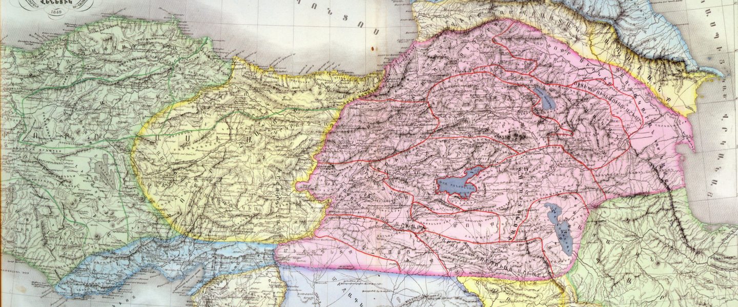
Армянское Нагорье (арм.-Հայկական Լեռնաշխարհ[Haykakan leṙnašxarh] (Айкакакан Лернашхар) или Հայկական Բարձրավանդակ (Айкакан Бардзравандак) или Հայկական Բնաշխարհ (Айкакакан Бнашхар), Միջնաշխարհ Հայոց (Миджнашхар айоц (арм. Средний мир армян)), рус.-Армянское Нагорье , Гор Араратских, Гор Армянских, Армянских Гор, анг.- The Armenian Highland, фр.-Plateau Armenien или Armenian Plateau, нем. Das Armenische Hochland или Das Armenische Bergland).Армянское нагорье-На других языках العربية- المرتفعات الأرمنية— арабский , Беларуская – Армянскае нагор'е, Беларуская (тарашкевіца) – Армянскае нагор’е — беларуская (тарашкевіца),Български – Арменско плато — болгарский, Català – Altiplà d'Armènia, Эрмалойн акъари — чеченский,Čeština-Arménská_vysočina,Armenisches Hochland — немецкий,Αρμενικά υψίπεδα — греческий,English Armenian Highlands — английский, Esperanto -Armena Altebenaĵo, Español – Altiplano Armenio, Eesti-Armeenia mägismaa — эстонский, Euskara-Armeniar goi-ordokia — баскский, فارسی سرزمین کوهستانی ارمنستان — персидский, Français – Haut-plateau arménien — французский,עברית רמת ארמניה — иврит, हिन्दी आर्मीनिया का पठार — хинди, Hrvatski Armenska visoravan — хорватский, Magyar Örmény-felföld — венгерский, Italiano – Altopiano armeno,日本語 -アルメニア高原 — японский, ქართული – სომხეთის მთიანეთი, Қазақша Армения таулы үстірті — казахский, 한국어 아르메니아 고원 — корейский, Lietuvių Armėnijos kalnynas — литовский, Македонски – Ерменска Висорамнина, Nederlands Armeens Hoogland — нидерландский, Norsk nynorsk Det armenske høglandet — нюнорск, Norsk bokmål Det armenske høylandet — норвежский, Polski Wyżyna Armeńska — польский, Português Planalto Armênio — португальский, Srpskohrvatski / српскохрватски Armenska visoravan — сербскохорватский,Simple English Armenian Highland — Simple English, Slovenčina Arménska vysočina — словацкий, Slovenščina Armensko višavje — словенский, Српски / srpski Јерменска висораван — сербский, தமிழ தமிழ ஆர்மேனிய மேட்டுநிலங்கள் — тамильский,Татарча/tatarça Әрмән таулыгы — татарский, Українська Вірменське нагір'я — украинский, Oʻzbekcha/ўзбекча Armaniston togʻligi — узбекский, Tiếng Việt Sơn nguyên Armenia — вьетнамский,中文 亚美尼亚高原 — китайский.
Armenian Highland the central of three Southwest Asiatic highlands; located mainly in Turkey, partly in the USSR and Iran. The part of the Armenian Highland that isin the USSR (the so-called Transcaucasian Highland) occupies all of the Armenian SSR, the southern Georgian SSR, and the western AzerbaijanSSR. In the broad sense of the word the Armenian Highland also embraces the Lesser Caucasus, the Armenian Taurus, and the KurdishMountains, taking in an area of approximately 400,000 sq km. In terms of structural geology, the Armenian Highland is a segment of theMediterranean alpide volcanic zone of folding with an extensive distribution of thick sedimentary layers from the Mesozoic and Cenozoic eras andintrusions of granitoid and ultrabasite rock mainly from the Upper Cretaceous, Paleocene, and Neocene periods. In the highland there arenumerous, often large deposits of chromite—for example, in Guleman (Turkey); copper pyrite ore, such as in Murgul (Turkey) and Kvartskhanra(USSR); arsenic, in Kagizman (Turkey); iron, gold, semimetallic ores, manganese, and rock salt in Kulp (Turkey); coal in Oltu (Turkey); andmanifestations of petroleum and natural gas. The topography consists of Neocene and Anthropocene lava plateaus topped with volcanic cones,which were uplifted by the most recent vaulting movements, and tectonic basins which remain from a general upheaval of the basin structure andwhich are divided by folding fault-block mountain ranges. Many mountain ranges (Dzhavakhet, Arsiianskii, Ağri Dağ) were formed by chains ofvolcanoes which sprang up along large fractures. The highest volcanoes are Great Ararat(5, 165 m), Sabalan (4,821 m), Süphan (4,434 m), andAragats (4,090 m). In historical times (1441) only the Nemrut volcano has been active. The largest nonvolcanic mountain ranges of the highlandare, in the Soviet part, the Zangezur and, outside the USSR, the Palandoken, Bingöl, Ala Dag, Qotur, Kara Dag, Mishab, Karabakh, Gegam, andBozqush. Characteristic of the highland are tectonic basins, parts of which are occupied by lakes (Van, Sevan, Urmia) with bottoms at altitudesfrom 700 to 2,000 m. Major hollows include Ararat, Erzurum, Mu, and Tabriz. The most extensive plateaus are the Kars, Ardahan, and Dzhavakhet.The climate of the Armenian Highland is subtropical continental. Annual precipitation averages 300–800 mm in the mountains and 150–300 mm inthe basins. Minimum precipitation occurs in the winter and maximum in the spring. Winters are long; there is frost in the mountains and snow in thenorth and west. Average temperature in January ranges from-3° to -15° C; in July the average is 15° to 20° C and up to 25° C in the basins. Theupper courses of the Kura, Aras (in Russian, Araks) Euphrates, and Great Zab (left tributary of the Tigris) rivers, as well as the large lakes Van,Urmia (saltwater), and Sevan, are all located in the Armenian Highland. There are many mineral springs, including thermal springs. The basins havearid steppes and mountainous semideserts. Soils are light chestnut and brown, ranging to sierozems. There are zones of river meadows andbrushwood along the watercourses and densely populated oases in the irrigated areas. From 800 to 1,400 meters the humid slopes havemountainous steppes with dark chestnut soils and chernozems; forests (oak, pine), brushwood overgrowth of the shibliak type, and stands ofjuniper are encountered in the lightly podzolized brown forest soils between 1,000 and 2,300 meters. Thickets of low-growing pillowlike thornybrushwood are widely distributed in the rocky soils on the less humid slopes. Regions of alpine meadows occur at elevations of 2,000 to 3,000 m,and above this zone craggy landscapes predominate. The summits of Great Ararat, Süphan, and Kaputdzhukh are covered with permanent snowand glaciers. There are many rodents and reptiles in the Armenian Highland; the roe deer, bezoar goat, mouflon, bear, leopard, and striped hyenaare also encountered.
Հայկական Լեռնաշխարհ The Armenian Highlands Армянское нагорье العربية- المرتفعات الأرمنية , Армянскае нагор’е, Армянскае нагор’е , Арменско плато , Altiplà d’Armènia, Эрмалойн акъари ,Čeština-Arménská_vysočina,Armenisches Hochlandй,Αρμενικά υψίπεδα ,English Armenian Highlands , Esperanto -Armena Altebenaĵo, Español – Altiplano Armenio, Eesti-Armeenia mägismaa — , Euskara-Armeniar goi-ordokia , فارسی سرزمین کوهستانی ارمنستان , Français – Haut-plateau arménien ,עברית רמת ארמניה , हिन्दी आर्मीनिया का पठार , Hrvatski Armenska visoravan , Magyar Örmény-felföld — , Italiano – Altopiano armeno,日本語 -アルメニア高原 , ქართული – სომხეთის მთიანეთი, Қазақша Армения таулы үстірті, 한국어 아르메니아 고원, Lietuvių Armėnijos kalnynas , – Ерменска Висорамнина, Nederlands Armeens Hoogland , Norsk nynorsk Det armenske høglandet , Norsk bokmål Det armenske høylandet , Polski Wyżyna Armeńska , Português Planalto Armênio , Srpskohrvatski / Armenska visoravan ,Simple English Armenian Highland — Simple English, Slovenčina Arménska vysočina, Slovenščina Armensko višavje , srpski, Јерменска висораван й, தமிழ தமிழ ஆர்மேனிய மேட்டுநிலங்கள் ,Татарча/tatarça Әрмән таулыгы , Українська Вірменське нагір’я, Oʻzbekcha/ўзбекча Armaniston togʻligi , Tiếng Việt Sơn nguyên Armenia ,中文 亚美尼亚高原 .


You must be logged in to post a comment.