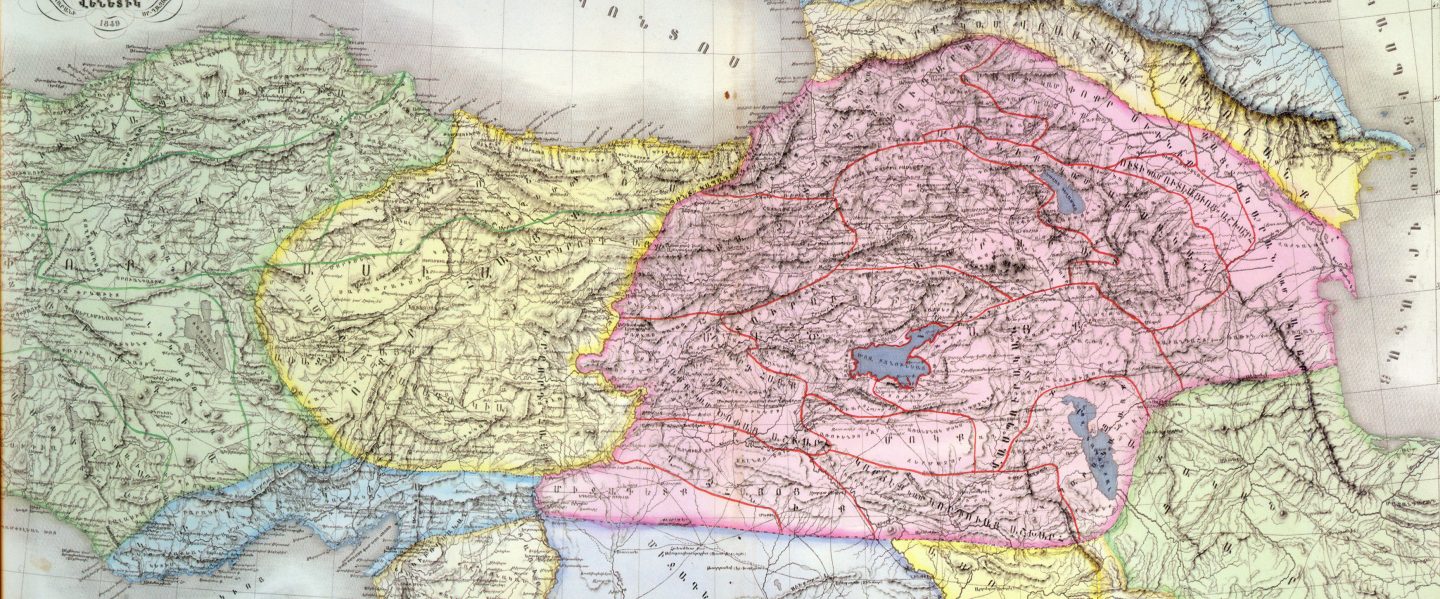


⚜️1691 թ․ Կոստանդնուպոլսում ստեղծված հայոց վանքերի և սրբավայրերի միջնադարյան խոշոր քարտեզը (մոտ 120 × 358 սմ) ոչ միայն աշխարհագրական, այլև պատմամշակութային արժեքավոր վկայագիր է։ Այն արտացոլում է հայկական աշխարհի տարածքները, սրբավայրերը և ժամանակի հոգևոր կյանքը։
Քարտեզը ստեղծվել է հայ մտավորական Երեմիա Չելեպի Քյոմուրճյանի և իտալացի քարտեզագիր Լուիջի Ֆերդինանդո Մարսիլիի համագործակցությամբ, որոնց հանդիպումը տեղի է ունեցել 1691-ին Կոստանդնուպոլսում՝ Օսմանյան և Հաբսբուրգյան կայսրությունների պատերազմի ժամանակ։
Քարտեզի վրա պատկերված են շուրջ 800 տեղանք՝ ներառյալ Էջմիածնի, Գանձասարի, Աղթամարի և Կիլիկիայի կաթողիկոսությունները, ինչպես նաև Երուսաղեմի և Կոստանդնուպոլսի պատրիարքությունները։ Մանրամասն ներկայացված է Վանա լիճը իր չորս կղզիներով, նշված են դրանց գլխավոր եկեղեցիներն ու պահվող սրբությունները։ Պատկերված են նաև Արարատն ու Արագածը, Սաղմոսավանքն ու շրջակա վանական համալիրները։
Քարտեզը ընդգրկում է պատմական Հայաստանի ողջ տարածքը՝ Արցախից մինչև Կոստանդնուպոլիս, ներառյալ Ղրիմի հայկական եկեղեցիներն ու վանքերը։
Մարսիլիի՝ Բոլոնիա վերադարձից հետո քարտեզի հետքերը երկար ժամանակ կորում են։ Միայն 1991 թ․ Բոլոնիայի համալսարանի հայագիտության պրոֆեսոր Գաբրիելլա Ուլոհոջյանը այն հայտնաբերում է համալսարանի հավաքածուում և հրատարակում։
Այդ ժամանակից ի վեր քարտեզը վերարտադրվել է և դարձել պատմական ու գիտական կարևոր աղբյուր:
⚜️This large medieval map of Armenian monasteries and sacred sites was created in 1691 in Constantinople. Measuring approximately 120 × 358 cm, it is not only a geographical work but also a rich historical and cultural testimony of the Armenian world.
The map was the result of a collaboration between the Armenian intellectual, poet, and political figure Eremia Chelebi Kömürjian and the Italian cartographer and diplomat Luigi Ferdinando Marsili, who met in Constantinople during the war between the Ottoman and Habsburg Empires.
It depicts nearly 800 locations, including major Armenian ecclesiastical centers such as Etchmiadzin, Gandzasar, Aghtamar, and the Catholicosate of Cilicia, as well as the Patriarchates of Jerusalem and Constantinople. Lake Van and its four islands are shown in detail, along with key monasteries, sacred relics, Mount Ararat, Mount Aragats, and numerous churches and monastic complexes.
The map covers the full extent of historical Armenia—from Artsakh to Constantinople—and also includes Armenian churches and monasteries in Crimea.
After Marsili returned to Bologna, the map disappeared from historical records for centuries. In 1991, it was rediscovered in the University of Bologna collection by Armenologist Gabriella Uluhogian, who subsequently published it.
Since its rediscovery, the map has been widely studied and reproduced, becoming an essential source for scholars of Armenian history and culture.
For more information:


You must be logged in to post a comment.